How to resolve AdBlock issue?
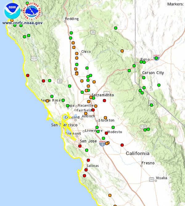
LAKE COUNTY, Calif. — State officials on Saturday evening gave an update on the powerful storm conditions moving across California, which in some areas have led to flooding.
California Department of Water Resources staff said a series of big storms will be hitting California this week, bringing not just more water but high winds.
State Climatologist Dr. Michael Anderson said a string of storms are underway. The first began on Dec. 27, and they are expected to continue until Jan. 19.
“We want to stay on this,” he said of the state’s effort to monitor the situation.
The next storm in the series was expected to come on shore on Saturday night, Anderson said.
That is to be followed by a second storm early in the week that’s a bigger concern and will have more impact, followed by storms three, four and five.
Precipitation maps developed by forecasters showed large amounts of rainfall statewide.
“We see some pretty astounding numbers here,” from the North Coast to San Diego, Anderson said.
He said the coming six days could see the state getting just as much rain as its already been through due to the unrelenting storms.
Anderson said a partnership of state and federal agencies, the Atmospheric River Recon, has several planes flying the storms, with that data being placed into National Weather Service forecast models.
The result, said Anderson, is an improved precipitation model that is helping with forecasting the coming storms.
Jeremy Arrich, manager of DWR’s Division of Flood Management, said the state’s Flood Operations Center has been activated since Jan. 3.
He said the center serves as a hub to gather and share information that’s used to support locally led flood emergency response efforts across the state.
The center can also supply direct materials, enlist crews and let out construction contracts for placing rock where needed or using other flood fighting methods to mitigate the impacts to levees or other areas.
As of Saturday night, he said there were 15 water systems in the state forecasted to exceed flood stage and 30 forecasted to exceed monitor stage.
According to the California Nevada River Forecast Center, the areas approaching flood stage that are closest to Lake County are the Russian River in Hopland and the Russian River in Guerneville.
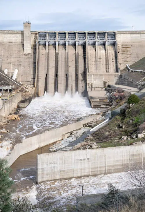
Arrich said that California’s two largest reservoirs connected to the Sacramento River system, Oroville and Shasta, both have a lot of room in them still, even after the heavy rains of the past few weeks.
“That’s going to be a big relief valve for us in terms of that available storage,” Arrich said.
“DWR expects widespread impacts in small streams and creeks across the state, localized street flooding, low lying areas, areas with poor drainage, and other areas that are prone to flooding like coastal areas, recent wildfire burn scar areas and areas prone to rock or mudslides,” he said.
Californians should pay attention to safety messages from local authorities, heed all signs posted on roadways, and absolutely never attempt to drive through a flooded roadway, Arrich said.
Arrich also urged people to have an evacuation plan and to leave immediately if local authorities direct it.
Over the past week, the Flood Operations Center has been very busy and has coordinated efforts to help deliver materials and equipment to 12 counties, including more than 150,000 sandbags, six flood fight containers, more than 3,000 linear feet of reinforcing muscle wall and deployment of flood fight specialists to various locations, Arrich said.
Materials and equipment also have been positioned at 49 locations statewide and are ready when needed, and specialists have been deployed to support counties and agencies in flood fighting efforts, Arrich said.
Arrich said incident command teams are prepared to be deployed statewide as needed, and they’ve also been reaching out to levee managers and counties and cities to keep them informed of high water conditions, and to coordinate increased levee and flood system patrols.
The Flood Operations Center also is coordinating with the state Office of Emergency Services and emergency officials on the local level, he said.
Late Saturday, Clear Lake’s level was at -0.24 feet Rumsey, the special measure for Clear Lake.
With the rainfall, it’s anticipated the lake will soon cross into the plus side.
Email Elizabeth Larson at This email address is being protected from spambots. You need JavaScript enabled to view it.. Follow her on Twitter, @ERLarson, or Lake County News, @LakeCoNews.