How to resolve AdBlock issue?
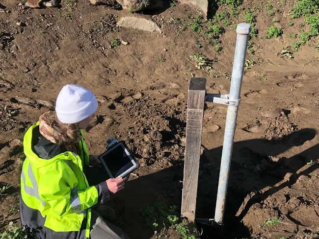
U.S. Geological Survey field crews measured high streamflows this past week throughout California, thirteen of which were record high-flow measurements.
These measurements provide information that protect life, property, and the environment including uses for water supply and management, monitoring floods and droughts, bridge and road design, determination of flood risk and many recreational activities
“Heavy rains and hazardous weather conditions continue in northern California this week,” said Mark Dickman, associate director of data for the USGS California Water Science Center. “Streamflows have been very high, and we expect more over parts of the region the next several days.”
USGS crews made 77 streamflow measurements at 58 streamgages between December 31, 2022 and January 2, 2023, and recorded 13 preliminary record-high streamflow measurements in northern California. To the east of Sacramento, crews captured the highest direct measurement ever recorded at streamgage 11335000 on the Cosumnes River near Michigan Bar, CA — 63,700 cubic feet per second — in over 100 years of record. Additional historic peaks are expected throughout the state this week, as another atmospheric river is likely to occur.
These data are used by the National Weather Service to develop flood forecasts, the U.S. Army Corps of Engineers to manage flood control and local agencies in their flood response activities.
“The SFPUC relies on accurate and real-time hydrology information for our water supply system and watershed land operations, particularly during storm events,” said Tim Ramirez with the San Francisco Public Utilities Commission. “Information regarding reservoir levels, and streams flowing into and from the reservoirs are critical data we use to make operational decisions, and we are grateful for the USGS staff out in the field during these storm events who are an important part of our team.”
There are 458 USGS-operated streamgages in California that measure water levels, streamflow, and rainfall automatically and send data wirelessly, which are accessible from the National Water Dashboard. When flooding occurs, USGS crews make numerous streamflow measurements to verify the data that the USGS provides to federal, state, and local agencies, as well as to the public.
For more than 125 years, the USGS has monitored flow in selected streams and rivers across the United States.
Access current flood and high flow conditions across the country by visiting the USGS National Water Dashboard. Receive instant, customized updates about water conditions in your area via text message or email by signing up for USGS WaterAlert.