- Wayne Diggs
A view from the top: Hiking Mt. Konocti

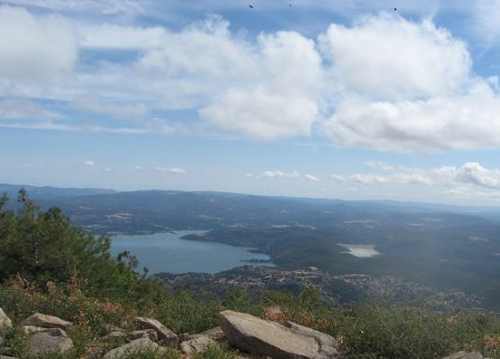
KELSEYVILLE, Calif. – How many of us have sat and looked at the majestic Mt. Konocti and wondered just what the view would be like if you could only get to the top?
Well, until just a few months ago, this was most likely not going to happen. Now it can.
Mt. Konocti is a dormant volcano thought to have last erupted perhaps 10,000 years ago. There is archaeological evidence of the Pomo and Wappo Indian occupation of the Clear Lake area over 11,000 years ago. Although they never inhabited Mt. Konocti, they were – as we are – awed by its beauty.
The park was acquired in 2009 by the county of Lake. The county-owned portion of the park is more than 1,500 acres, with nearly 800 adjoining acres owned by the Bureau of Land Management.
So, let’s get started. Pick up the county brochure as there are some interesting facts here as well as a good map of the hike. These are available at the county parks office and sometimes at the gate. Information about the park also can be found here: http://www.konoctitrails.com/trails-information/mt-konocti-regional-park.
First off, at least initially, the county has placed several restrictions on the use of the park. Basically you can only bring your kids and your lunch. No dogs, motorized vehicles, bikes or horses.
Start out in downtown Kelseyville and take Konocti Road at the south end of town. You will drive up about four miles and come to the main gate, another mile or so to the main parking lot.
The road will be dusty or perhaps a bit muddy now that the rains have started, but it is a good solid surface gravel road, suitable for just about anything with four wheels.
Once you leave the parking lot, follow the road up to another gate and pedestrian turn-stile. This stretch is going to fool you though. It seems so easy at first. Let's not quibble about it, this isn’t an easy hike, but not really too difficult either. You will gain 1,650 feet in elevation, and it is truly a six mile round trip, to the top of Wright Peak and the fire tower.
Very quickly you start up hill. As you skirt off the fire road to avoid private property, it gets really steep for about one-quarter mile. This is the test, make this and you can do the rest.
I am going to describe this in terms of time, not miles as most of us have no idea of how long a mile is when you are walking it. I am well into my 60ss and not a professional hiker. It took me two hours and 15 minutes total, about one and three-quarters hours of actual hiking to reach the top.

So, the first hour is a mostly a steady uphill climb with glimpses of lake views towards the north and west; some very nice views of Lakeport and Kelseyville.
You will come to the first fork in the road; going left takes you to Buckingham Peak (elevation 3,952 feet) which is a five-mile round trip, better left for another day. Continue for another 15 minutes into a stand of towering canyon oaks, some believed to be more than 500 years old. You are now at 3,500 feet in elevation, well on your way to the top at 4,299 feet in elevation.
As you pass through the deep forest, just past the second walnut orchard you will come to a road off to your right. This is a lesser used road which will take you to Mary Downen’s cabin built in 1903. She lived here and tended her walnut orchard, by herself, signaling her daughter in Lakeport with a mirror every day at 2 p.m. that all was well.
I spent about 20 minutes looking at the cabin and surrounding area; it was a nice placed to take a break. I saw several deer and evidence of other wild life in the little orchard. From here it took me half an hour of steady hiking, up some 10 percent to 12 percent grades and I was at the top.
Continuing on back to the main road, you really start to gain elevation from here to the top. About 15 minutes from the top you will see a road off to the left which will take you to Howard Peak at 4,286 feet elevation, about a half-mile diversion. Again, I left this for another day.
Soon, you have arrived at the top and will be greeted by the fire tower, which in my case I had looked at through my telescope many times and wondered just what it would look like close up. It is a bit taller and larger than I expected, and kind of shaky looking. But, it was built 1964 and has withstood the test of time.
I was a bit disappointed that the county had not cleared the brush blocking your view toward the north. Unless you hit it on a day when the docent is on duty, you can not climb the tower for the best 360-degree unobstructed views. However, looking to the south I was able to clearly see the top of Mount St. Helena at 4,330 feet elevation, just a few feet higher than my location. Looking a bit east I could see the Sutter Buttes and to the west the Mayacamas and the steam from the Geysers.
It took me a total of two hours 15 minutes to reach the top of Wright Peak and the tower, which included a 20- to 30-minute break at Mary’s cabin. This is a 1,650 foot gain in elevation from the parking lot.
If you are younger or a more experienced hiker you could make it in less time, but I think that anyone in reasonable shape who does some hiking can do this trip. Back to the car took one hour and 30 minutes and it was all downhill. There are three porta-potties along the way, but no source for water.
This is a hike that is best done on a cool day, when the top of the mountain is clear of fog or mist. It is well worth the effort if only to be able to say, “I hiked to the top.”
Follow Lake County News on Twitter at http://twitter.com/LakeCoNews, on Tumblr at www.lakeconews.tumblr.com, on Facebook at http://www.facebook.com/pages/Lake-County-News/143156775604?ref=mf and on YouTube at http://www.youtube.com/user/LakeCoNews .


 How to resolve AdBlock issue?


