LAKE COUNTY, Calif. – Cal Fire and the county of Lake will host a virtual community meeting to provide information on the LNU Lightning Complex on Monday, Aug. 24.
The meeting will begin at 6 p.m.
It will be broadcast live on Facebook and PEG TV Channel 8.
Those who wish to ask questions can participate via Zoom; meeting ID is 913 3863 4529, passcode is 094776. They also can call in with one tap mobile at +16699006833,,91338634529#,,,,,,0#,,094776#US.
Participants in the event are expected to include representatives from Cal Fire and the Lake County Sheriff’s Office, and also partnering agencies that have been crucial to Lake County’s response to this wildfire event, including representatives of the Red Cross, county health and social services agencies, Lake County Behavioral Health Services and more. They will be available to answer constituent questions. Local elected representatives will also be invited.
“This will be a virtual meeting, so we can have the very best people participate while allowing them to primarily focus on the firefighting and life-saving activities that matter most right now,” said Lake County Sheriff Brian Martin. “Our goal is to get you information you need to respond to this disaster, whether you are currently under evacuation, or concerned about how the fires may evolve in days to come.”
“We are grateful to Cal Fire and our other partners for understanding the importance of sharing information during an event like this,” said Martin. “People are facing the loss or potential loss of homes, loved ones and ways of life. That places a strain on entire communities. Our hope is this event will reach a lot of people that are connected to Lake County, and help them evaluate their next steps.”
LAKE COUNTY, Calif. – The National Weather Service has issued a red flag warning for Lake County and much of the rest of Northern California as forecasters predict a combination of thunderstorms and high winds will result from the remains of a tropical storm passing through the region.
The red flag warning is in effect until 11 p.m. Monday.
A red flag warning means that critical fire weather conditions are either occurring now or will shortly.
The forecast warns of the potential fire starts due to “abundant lightning” that’s possible from Sunday night through early Tuesday morning.
The National Weather Service said a moist and unstable midlevel airmass is expected to spread north across the region on Sunday, with isolated thunderstorms possibly developing over Mendocino and Lake counties during the day.
“Additional thunderstorm development will be more likely Sunday night into Monday morning across much of Northwest California as the remnants of a tropical system move north across the area,” according to the forecast.
Forecasters warn of another round of storms that will be possible on Tuesday morning as a second upper disturbance moves eastward across the region.
“Lightning combined with dry fuels will increase the threat for fire starts during each episode of storm development,” the forecast said.
Other concerns cited in the National Weather Service’s long-term forecast include high temperatures close to the century mark through Monday before conditions cool slightly, dropping into the low to mid 90s through the weekend.
Smoke from the LNU Lightning Complex and other regional fires also is expected to continue to impact Lake County through at least Tuesday, the forecast said.
Email Elizabeth Larson at This email address is being protected from spambots. You need JavaScript enabled to view it.. Follow her on Twitter, @ERLarson, or Lake County News, @LakeCoNews.
This illustration shows asteroid 2020 QG's trajectory bending during its close approach to Earth. The asteroid is the closest known nonimpacting asteroid ever detected. Credits: NASA/JPL-Caltech. An SUV-size space rock flew past our planet last weekend and was detected by a NASA-funded asteroid survey as it departed.
Near Earth asteroids, or NEAs, pass by our home planet all the time. But an SUV-size asteroid set the record this past weekend for coming closer to Earth than any other known NEA: It passed 1,830 miles (2,950 kilometers) above the southern Indian Ocean on Sunday, Aug. 16 at 12:08 a.m. EDT (Saturday, Aug. 15 at 9:08 p.m. PDT).
At roughly 10 to 20 feet (3 to 6 meters) across, asteroid 2020 QG is very small by asteroid standards: If it had actually been on an impact trajectory, it would likely have become a fireball as it broke up in Earth's atmosphere, which happens several times a year.
By some estimates, there are hundreds of millions of small asteroids the size of 2020 QG, but they are extremely hard to discover until they get very close to Earth. The vast majority of NEAs pass by safely at much greater distances – usually much farther away than the Moon.
"It's really cool to see a small asteroid come by this close, because we can see the Earth's gravity dramatically bend its trajectory," said Paul Chodas, director of the Center for Near-Earth Object Studies (CNEOS) at NASA's Jet Propulsion Laboratory in Southern California. "Our calculations show that this asteroid got turned by 45 degrees or so as it swung by our planet."
Zipping along at almost 8 miles per second (12.3 kilometers per second) – a little slower than average, Chodas noted – 2020 QG was first recorded as just a long streak in a wide-field camera image taken by the Zwicky Transient Facility.
The image was taken six hours after the closest point of approach as the asteroid was heading away from Earth. A sky-scanning survey telescope funded by the National Science Foundation and NASA, the Zwicky Transient Facility is based at Caltech's Palomar Observatory in San Diego County. NASA's Near-Earth Object Observations Program funds data processing for NEO detections.
Asteroid 2020 QG enters the record books as the closest known nonimpacting asteroid; many very small asteroids impact our planet every year, but only a few have actually been detected in space a few hours before impacting Earth. On average, an asteroid the size of 2020 QG passes this closely only a few times a year.
In 2005, Congress assigned NASA the goal of finding 90% of the near-Earth asteroids that are about 460 feet (140 meters) or larger in size. These larger asteroids pose a much greater threat if they were to impact, and they can be detected much farther away from Earth, because their rate of motion across the sky is typically much smaller at that distance.
"It's quite an accomplishment to find these tiny close-in asteroids in the first place, because they pass by so fast," Chodas said. "There's typically only a short window of a couple of days before or after close approach when this small of an asteroid is close enough to Earth to be bright enough but not so close that it moves too fast in the sky to be detected by a telescope."
A division of Caltech in Pasadena, JPL hosts CNEOS for NASA's Near-Earth Object Observations Program in NASA's Planetary Defense Coordination Office.
More information about CNEOS, asteroids and near-Earth objects can be found at https://cneos.jpl.nasa.gov.
The circled streak in the center of this image is asteroid 2020 QG, which came closer to Earth than any other nonimpacting asteroid on record. It was detected by the Zwicky Transient Facility on Sunday, Aug. 16 at 12:08 a.m. EDT (Saturday, Aug. 15 at 9:08 p.m. PDT). Credits: ZTF/Caltech Optical Observatories.
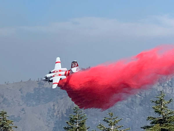
Air tanker support on the Hull fire on the Mendocino National Forest’s Upper Lake Ranger District in Lake County, California. Credit: US Forest Service. LAKE COUNTY, Calif. – A lightning-caused fire in the Mendocino National Forest has led to an evacuation warning for residents near Lake Pillsbury.
The Hull fire, located five miles north of Lake Pillsbury on the Upper Lake District of the Mendocino National Forest, is 2,500 acres and zero-percent contained, forest officials said Sunday.
The fire was detected on Wednesday after several rounds of thunderstorms occurred across the forest last week.
The Lake County Sheriff’s Office on Sunday issued an evacuation warning for Pillsbury Ranch due to the Hull fire.
The evacuation warning includes areas north of M-1, south of the Lake County line, west of Bloody Rock and east of the Lake County Line.
There are 49 personnel committed to the incident including seven engine crews, one hand crew and operations managers, the Forest Service said.
Officials said crews are challenged by steep, rugged terrain where the fire is rolling out and making uphill runs. On Saturday, air tankers assisted crews in containing a slopover on Road 38.
The fire is burning in timber on the north and east aspects of Hull Mountain and is active in Hull Creek, backing down into Rattlesnake Creek and spreading north along Panther Ridge, according to the Forest Service’s Sunday report.
The Forest Service said the fire is threatening cabins to the south and other private property may become threatened as the fire progresses northward.
Officials said smoke in the community of Potter Valley and the Pillsbury Subdivision has degraded air quality. A known sensitive air quality area is located east of the fire in the Snow Mountain Wilderness.
A red flag warning is in effect from 11 p.m. Sunday to 11 p.m. Monday in the fire area, where winds could gust as high as 40 miles per hour.
There is a road closure in effect on Forest Road M1 to Forest Road M6 on Road 18N016. In addition, the forest has an area closure in place due to the August Complex.
NORTHERN CALIFORNIA – Officials reported that a complex of lightning-caused fires is continuing to burn up acreage in the Mendocino National Forest.
The August Complex on the Mendocino National Forest’s Grindstone Ranger District burned 160,005 acres by Saturday night, with containment at 11 percent, the US Forest Service reported.
The complex, located 30 miles northeast of Willows, began burning last Sunday, in the wake of thunderstorms that passed over the region.
The Forest Service said it’s made up of 20 fires.
In a Saturday report, forest officials said the complex had so far destroyed 10 structures.
The largest of the fires include the Doe, 136,430 acres; the Glade, 13,088 acres; the Tatham, 7,667 acres; the Hopkins, 2,153 acres; and the Willow Basin, 601 acres.
The Forest Service said firefighters are working with Cal Fire to construct dozer lines along County Road 306 in Glenn County to provide protection to private homes and properties against the Tatham fire, which is four miles west of Paskenta.
Officials said fire crews are going direct on the west flank of the Glade fire and making good progress while continuing to protect property at risk on the east and southeast side of the fire.
The Hopkins fire is burning in an old fire scar in the Yolla Bolly wilderness and is staffed with smokejumpers, officials said.
The Forest Service said 397 firefighting personnel and 124 overhead personnel, 28 engines, three helicopters, seven bulldozers, four water tenders and seven crews are assigned to the complex.
Also in the Mendocino National Forest, the 2,000-acre Hull fire is burning five miles north of Lake Pillsbury on the Upper Lake Ranger District.
Officials said Saturday that the fire, caused by lightning, was discovered on Wednesday.
Email Elizabeth Larson at This email address is being protected from spambots. You need JavaScript enabled to view it.. Follow her on Twitter, @ERLarson, or Lake County News, @LakeCoNews.
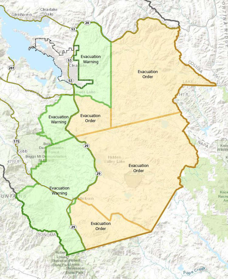
A map of the areas under evacuation orders and warnings in Lake County, California, due to the LNU Lightning Complex as of Saturday, August 22, 2020. Photo courtesy of the county of Lake.
LAKE COUNTY, Calif. – Firefighters held the LNU Lightning Complex to a smaller amount of daytime growth on Saturday as more resources arrived to assist the effort.
The complex was up to 325,128 acres on Saturday night, a growth of just under 11,000 acres during the course of the day, with containment remaining at 15 percent.
On Thursday and Friday, the complex had grown 84,000 and 83,000 acres, respectively, as Lake County News has reported.
The Hennessey fire, the portion of the complex burning in Lake, Napa, Solano and Yolo counties, has so far burned 271,714 acres and is 17-percent contained, Cal Fire said.
On the Sonoma County side of the fire, the Walbridge fire west of Healdsburg is up to 51,069 acres and the Meyers fire north of Jenner is at 2,345 acres. Cal Fire said there is no containment on either of those fires.
On Saturday evening, Cal Fire said the number of structures destroyed increased to 845, with damaged structures numbering 231. Another 30,500 remain threatened.
Cal Fire Sonoma Lake Napa Unit Chief Shana Jones said in a Saturday morning briefing that the LNU Lightning Complex remains the No. 1 priority in the state for resources that become available.
“Within an incident this size and complexity, and with all the fire activity throughout the state, all of our resources remain stretched to a capacity that we have not seen in recent history,” Jones said.
More resources are coming in from out of state to help fight the fires around California, but Jones said, “We are not out of the woods.”
A few hundred more firefighters and dozens of additional engines joined the fight on Saturday. Cal Fire said assigned resources included 1,704 personnel, 233 engines, 33 water tenders, 11 helicopters, 15 hand crews and 37 dozers.
The fire’s continued growth led to the Lake County Sheriff’s Office issuing a new evacuation order for areas near Lower Lake and an evacuation warning for areas north of Lower Lake to Highway 20, excluding the city of Clearlake.
An evacuation order for the Hidden Valley Lake and Jerusalem Valley areas remains in effect, as does an evacuation warning for the greater Middletown area, including Middletown proper.
As predicted on Saturday, the wind shifted and caused Lake County’s air basin to fill with smoke, making visibility challenging for firefighting forces, according to radio reports.
Email Elizabeth Larson at This email address is being protected from spambots. You need JavaScript enabled to view it.. Follow her on Twitter, @ERLarson, or Lake County News, @LakeCoNews.
The LNU Lightning Complex in Northern California, as mapped by Cal Fire on Sunday, August 23, 2020. LAKE COUNTY, Calif. – Firefighters are being challenged by heat and smoky conditions as they battle the growing LNU Lightning Complex.
The fire added another 16,000 acres overnight, growing to 341,243 acres by Sunday morning. Containment edged up a few percentage points to 17 percent, Cal Fire reported.
The main fires in the incident are the Hennessey fire, burning in Lake, Napa, Solano and Yolo counties, and the Walbridge and Meyers fires in Sonoma County.
The Hennessey fire was up to 287,811 acres and 17-percent containment on Sunday morning, Cal Fire said.
Cal Fire’s Sunday mapping showed black containment line on the eastern side of the fire and the southern end that had burned into Solano County. All portions of the fire in Solano County now have containment lines around them.
The Walbridge, west of Healdsburg, has grown to 51,072 acres and the Meyers, north of Jenner, is at 2,360 acres. Cal Fires said firefighters have so far not been able to get containment on either of those fires.
The assessment of structures destroyed remained at 845 on Sunday morning, with another 231 damaged and 30,500 threatened, Cal Fire reported.
The evacuation orders and warnings for southern Lake County remain in effect because of the fire’s growing footprint to the southwest of Lower Lake and east of Hidden Valley Lake.
Shortly after 1 p.m. Sunday, radio reports on the incident indicated that heavy smoke was once again an issue, and that air operations were being suspended temporarily due to airports in the region being closed because of lack of visibility.
That’s challenging firefighters who are asking for air support in areas where there are flareups – including Berryessa Estates – and where the fire is threatening containment lines.
Resources assigned appear to have remained unchanged since Saturday evening, with 1,704 firefighters, 233 engines, 33 water tenders, 11 helicopters, 15 hand crews and 37 dozers working the incidents.
Cal Fire and local officials will hold a virtual community meeting for Lake County residents at 6 p.m. Monday, Aug. 24. The meeting will be available on Facebook, PEG TV Channel 8 and via Zoom. The meeting ID is 913 3863 4529, passcode is 094776.
Email Elizabeth Larson at This email address is being protected from spambots. You need JavaScript enabled to view it.. Follow her on Twitter, @ERLarson, or Lake County News, @LakeCoNews.
LAKE COUNTY, Calif. – Lake County Animal Care and Control has a selection of larger dog breeds available to new homes this week.
Dogs available for adoption this week include mixes of American Staffordshire Terrier, chow chow, German Shepherd, Great Pyrenees, husky, Labrador Retriever and pit bull.
Dogs that are adopted from Lake County Animal Care and Control are either neutered or spayed, microchipped and, if old enough, given a rabies shot and county license before being released to their new owner. License fees do not apply to residents of the cities of Lakeport or Clearlake.
The following dogs at the Lake County Animal Care and Control shelter have been cleared for adoption (additional dogs on the animal control Web site not listed are still “on hold”).
“Pina” is a young female pit bull terrier in kennel No. 26, ID No. 13842. Photo courtesy of Lake County Animal Care and Control. ‘Pina’
“Pina” is a young female pit bull terrier with a short tan and brindle coat.
She is in kennel No. 26, ID No. 13842.
This male German Shepherd-pit bull mix is in kennel No. 27, ID No. 13841. Photo courtesy of Lake County Animal Care and Control. German Shepherd-pit bull mix
This male German Shepherd-pit bull mix has a black and brindle coat.
He is in kennel No. 27, ID No. 13841.
“Turbo” is a young male German Shepherd-husky mix in kennel No. 28, ID No. 13903. Photo courtesy of Lake County Animal Care and Control. ‘Turbo’
“Turbo” is a young male German Shepherd-husky mix.
He has a medium-length gray and black coat.
He is in kennel No. 28, ID No. 13903.
“Raven” is a female black Labrador Retriever in kennel No. 29, ID No. 13902. Photo courtesy of Lake County Animal Care and Control. ‘Raven’
“Raven” is a female black Labrador Retriever.
She has been spayed.
She is in kennel No. 29, ID No. 13902.
This male Great Pyrenees is in kennel No. 31, ID No. 13900. Photo courtesy of Lake County Animal Care and Control. Great Pyrenees
This male Great Pyrenees has a long cream-colored coat.
He is in kennel No. 31, ID No. 13900.
This male chow chow is in kennel No. 33, ID No. 13795. Photo courtesy of Lake County Animal Care and Control. Male chow chow
This male chow chow has a medium-length black coat.
He is in kennel No. 33, ID No. 13795.
“Chopper” is a male American Staffordshire Terrier in kennel No. 34, ID No. 13886. Photo courtesy of Lake County Animal Care and Control. ‘Chopper’
“Chopper” is a male American Staffordshire Terrier with a tan and white coat.
He has been neutered.
He’s in kennel No. 34, ID No. 13886.
Email Elizabeth Larson at This email address is being protected from spambots. You need JavaScript enabled to view it.. Follow her on Twitter, @ERLarson, or Lake County News, @LakeCoNews.
LAKE COUNTY, Calif. – The Lake County Sheriff’s Office is asking residents north of Lower Lake – not including the city of Clearlake – to be prepared to evacuate should the LNU Lightning Complex advance further into Lake County.
Shortly before 4:30 p.m. Saturday, the sheriff’s office issued an evacuation warning for all residences and areas east of Highway 29, north of Morgan Valley Road, south of Highway 20 and west of the previous warning/evacuation line at Sky High Ridge Road, from Morgan Valley Road extending north to Highway 20, not to include any residents within the city limits of Clearlake.
“We are asking everyone to take preparations in the event that a mandatory evacuation order is issued. Preparations should include gathering all medications, important documents, making plans for pets, and notifying family members where you may be going. Those requiring additional time to evacuate or those with pets or livestock should leave the area as soon as possible,” the sheriff’s office said.
The sheriff’s office urged people to evacuate early in order to avoid hectic traffic conditions and keep themselves, their neighbors and first responders safe.
Should an evacuation order be issued and shelter is needed, evacuees will be directed to a temporary evacuation point.
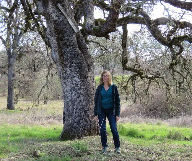
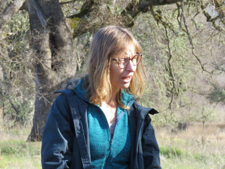
Cathy Koehler at the Rodman Preserve near Upper Lake, California. Photo by Kathleen Scavone.
LAKE COUNTY, Calif. – Cathy Koehler doesn't allow any moss to grow under her feet, although she may have studied those plants.
She has worn many hats during her scientific endeavors: director of the McLaughlin Natural Reserve outside of Lower Lake, conducting research in both North American and International field stations, teacher of zoology and ecology, hosting public outreach events at McLaughlin Reserve, participating in K-12 science education programs and more.
According to the preface by Alexander N. Glazer in the book, “The Environmental Legacy of the UC Natural Reserve System,” University of California Press, “Because of the stewardship, dedication, and effectiveness of its staff, the reserve system has for close to half a century made it possible for students and faculty to advance public understanding of natural environments and their complex functioning."
He further states, “During the past 150 years, widespread disregard for the integrity of the natural world has resulted in a level of disruption with frightening implications for the future. In this situation, the value of the research and teaching that the Natural Reserve System (NRS) enables has become widely evident.”
The 41 reserves that are part of the UC Natural Reserve System, or NRS, system in California function as outdoor laboratories. By providing locations for research and teaching, they contribute to humanity's understanding of how the natural world works, which informs us about the needs of our species and how we humans are impacting our world.
The reserves provide the people living in nearby local communities with opportunities to engage with researchers and land stewards working to understand ecological and evolutionary principles as well as California's human histories.
Some of the nearby Northern California reserves include the Bodega Marine Reserve in Sonoma County, Hans Jenny Pygmy Forest Reserve in Mendocino County, Chickering American River Reserve in the Sierra Nevada mountains, Jepson Prairie Reserve near Davis, and the Donald and Sylvia McLaughlin Natural Reserve which straddles Lake, Napa and Yolo counties.
The McLaughlin Reserve, established in 1992 as 80 wildland acres on which scientists could conduct research within the land holdings of Homestake Mining Co.'s McLaughlin Project, expanded in 2002 to more than 7,000 acres when the mining effort ended.
The reserve is operated by the University of California, Davis, and is unique in many respects from the other reserves of the NRS in that its origins were in the vision of management team of Homestake Mining Co.'s McLaughlin Project, which operated a gold mine that employed around 200 people at the site from the 1980s to the 2000s.
Today it is producing world-class science because this is where scientists of all ilk come to study geology, ecology, archaeology and more.
Following is an interview with Cathy, via email.
Q. With all of the science that goes on at the Reserve, are there more plans for “citizen scientist” projects such as your Reserve hikes, collaborations with the community through the Middletown Art Center and the public lectures you have held out there? (Mary Ellen Hannibal's book, “Citizen Scientist – Searching for Heroes and Hope in an Age of Extinction” should have mentioned your work!)
A. I see a difference between outreach activities (to bring the science conducted at, and knowledge about, McLaughlin to the interested public) and citizen science activities. The outreach opportunities we offer continue in the form of some educational hikes and seasonal "wildflower walks," possibly lectures depending on researchers and their interest in presenting, and on occasion collaboration with other organizations like MAC.
However, citizen science opportunities would be different. Anyone interested in being a citizen scientist could attend our outreach events, but the events themselves are not offering the "science" opportunities.
Science is a process, it's "a way of knowing" (in the words of Dr. John Moore), a way of looking at and understanding the natural world." It's basically an action, which means that citizen scientists need to be engaged in activities that help us understand the natural world.
To that end, there are ways that interested folk can contribute to collecting and sorting the information that helps us understand our world, and they can participate in the activities that we engage in at the reserve to support science. So, if there are individuals out there who would like to commit to some simple or more involved activities, and become a part of advancing the scientific pursuits at the reserve, they are welcome to contact us and we'll help them identify how to become contributors in ways that are meaningful to them.
Of course, there are also ways of contributing to the reserve without committing to science … volunteers who are interested in becoming part of the function and fibre of the place in other ways are also welcome to work with us to craft a way that they can have a meaningful experience and contribution.
I have all sorts of ideas on how people can become involved with the feserve, and have meaningful input and contributions to science and conservation. It would be great to have a dedicated "volunteer" base of people who are willing to become trained contributors to the McLaughlin team and regularly come out here to do their citizen science task.
Alas, it's hard to find people who would like to be regular contributors instead of just lending a hand at one-time education or volunteer events. I'd be happy to create a real citizen science program, though, if there are individuals who are willing to invest the time and enthusiasm to be citizen scientists!
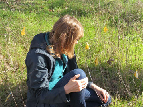
Cathy Koehler at a native grass planting event at the Rodman Preserve near Upper Lake, California. Photo by Kathleen Scavone. Q. Can you talk a bit about your experiences on becoming a scientist and what led to your career? For example, in the book "Lab Girl" by acclaimed scientist, Hope Jahren she discussed the mostly male scientists and the sometimes intolerant and dismissive attitudes she faced when starting her career.
A. It was fun reading "Lab Girl,” lots of things resonated with me and my experiences. But there were also differences.
For myself, coming out of high school I knew I wanted to pursue either art or biology. I chose biology, but that huge and encompassing word does not really provide much of a career framework other than outlining that you want to work with living things! I tended to want to work with animals, but not in a lab setting, so initially envisioned that vet school would be a way to have a career working with animals.
But in my third year of university, I had the good fortune to personally meet some bats which led to a fascination with them, and the opportunity to interact with them by working with a professor who studied bat ecology, and so I found myself with the opportunity to get involved in research in animal ecology.
I worked in bat research for my undergraduate thesis and my masters in science (at the University of Calgary), and thereafter started working in wildlife ecology. After a number of years working field jobs, I started a Ph.D. program. This was the first time I had a chance to formally teach science to undergraduate students as well as k-12 students and teachers.
I quickly realized that being an ambassador for science and helping people understand the ways that science allows us to understand our world was much more exciting to me than was being the person who is doing the extremely detailed experimental design and data collection that is the bedrock of science, and which is necessary in order for us to be confident in our understanding of the results of our inquiries.
So I aborted the Ph.D. pursuit and, in addition to continuing to work with other scientists on various projects, got involved in teaching science-content workshops for k-12 teachers and managing a public outreach program for a botanic garden while my husband finished his Ph.D.
We both wanted to continue working in wildlands, and having worked at research stations every year since I was 21, I could see that working in support of research at such a station would be a good use of my skills. When the opportunity to operate a research station arose, my husband and I co-applied and got the job at the McLaughlin Reserve.
You ask about a female scientist working amidst colleagues who are mostly male. Interestingly, I never felt marginalized or otherwise judged in my wanderings through the world of scientific inquiry. I was often the solo female, or one of only two or three females, in a group of mostly male colleagues (professors and graduate students), but did not reflect upon the gender distribution of these groups until it started to be pointed out to me.
I was invited to the nascent "Women in Science" outreach efforts that started to arise in the mid 1980s, but was never motivated to become involved in meetings or discussions, in part because I am not a person who gravitates toward clubs, support groups, or other gatherings based on a characteristic/distinction, and in part because I personally never felt disadvantaged or treated differently because of my gender.
I was also generally not aware of any academic inequality for females. However, I did encounter instances of male professors making sexual advances on female students, although apparently not in a quid-pro-quo way.
Alas, no sector of our modern societies seems to be immune to that, and maybe human civilization will see a slow shift away from patriarchal dominance in cultures in the next few centuries!
Q. Along with NASA scientists who have been out to the reserve studying our unique-to-this-part-of-the -world serpentinite, can you tell us about a couple of other unique studies that have taken place out there?
A. Well, I wouldn't say that serpentinite is unique to this part of the world. It is globally rare, and limited to continental edges where oceanic plates have subducted. Maine and Vermont, in fact, have serpentinites evidencing an ancient and long-defunct subduction zone on the east coast.
As for the work with the NASA scientists, Dawn Cardace moved on to a faculty position after her postdoc at NASA, and through collaborations driven by her and her NASA colleagues the work at McLaughlin has grown into a collaborative with investigators from numerous universities across the country.
What was unique about the location, here at McLaughlin, is that you had not only extensive and accessible serpentinites, but they were located within a research station.
The value of research stations to scientific inquiry is huge: it is very risky setting up experiments in areas that could be disturbed (incidentally or intentionally) by recreation or development, so what could be better than the availability of a location that is designated for research and teaching and has the attributes that are needed for your research?
All sorts of interesting studies have taken place here. Because the landscape in our region is very complex, with the jumble of geologic substrates supporting a jumble of different plant communities (and therefore our region comprises a globally notable area of high biodiversity), it lends itself well to scientific investigations that seek to understand about how plants adapt to challenging soil and climate conditions.
In the last decade there have also been several studies investigating how different plant communities might respond to climate change.
Because the reserve is also a location where land stewardship is maintaining native grassland and wildflower prairies, the year-round flowering of native plants (exemplified in the spring by tremendous wildflower blooms) support healthy populations of native pollinators, along with quite a few research projects that study those pollinators.
Q. What are you and other scientists studying at the reserve in relation to the effects climate change is having on our county and California?
A. Not a huge talking point for McLaughlin. McLaughlin is not a site that lends itself well to nailing down the effects of climate change. It is not on the coast, and it is not alpine (two ecosystems that are more likely to exhibit blatant manifestations of ecological responses to directional shifts in climate).
And the Mediterranean region of California is notable for how variable the climate is from year to year; it is normal for the Mediterranean region of California to have years of abundant rainfall, and years of very little rain, and everything in between.
Ecological studies on the effects of climate change produce clear results more-so in locations that are less variable because then the researcher can introduce variability (in temperature and precipitation) that exposes plants and animals to more unique conditions.
That's why we mostly hear about climate change research that is being conducted in coastal areas, in the Colorado mountains, in arctic regions.
That being said, the reserve has been host to research that sheds some light on ecological responses to climate change. A long-term data set, from research that initially intended to record shifts in plant species abundance and diversity in association with the normal year by year climatic variability, has revealed unanticipated shifts in plant community composition over a couple of decades in association with directional shifts in weather patterns associated with global warming.
Long-term data sets are rare .... so many research projects only last a few years which makes it hard to study the effects of variation in a highly variable environment! So it's great when a good long-term data set exists, and allows people to look back in time to pick out patterns that were not initially intended to be studied.
That data set has allowed for the development of meaningful experiments that can manipulate the plant community and the weather patterns to further investigate the plant community shifts that have been observed in the past couple of decades.
Q. As a former educator, what would you recommend that children, girls, in particular, study or get involved in to further their budding science interests?
A. We know children are naturally curious. I think most of them have budding science interests, which start by just watching the world around them. Let’s spend more time getting kids outdoors and interacting with nature.
Patient observation generates questions (why are those ants all on the branches of that shrub species, but not the other one? Why does this one kind of plant have small leaves here, but big leaves over there? Look at how hard it is for that bug to walk along a leaf that is hairy compared to a smooth leaf! Does that mean the smooth leaf is easier for bugs to eat? Why do I find mammal poop on top of rocks, and whose poop is it?).
And those questions become the building blocks of investigation and critical thinking. So, let's spend more time in the best classroom of all .... nature. And let's encourage kids who are energized by poking around and looking at nature to try to answer some of their questions.
And, if scientists are nearby, kids should be encouraged to hang out with them (and the scientists should be receptive to having kids hanging out!).
Cathy Koehler. Photo by Kathleen Scavone.
Q. Is the reserve still promoting and involved in science for our local schools? I am thinking in particular of the Science and History Day at Ely, the Lake County Geology tour, etc.
A. Not as much as when Paul and I first got here, but yes we still are. I have teachers contact me to craft a field trip for their classes, or to have me come to their classroom. Also, there is an annual program being implemented by UC Davis graduate students that brings locally-relevant ecology to students in Lower Lake Elementary school and culminates with a field trip to McLaughlin.
If you want to mention opportunities for k-12 education at McLaughlin, the best way to phrase it would probably be to tell teachers to reach out to me if they are interested in a field trip or having me come into their classroom.
Q. Since McLaughlin ended their mining operations and began restoring the lands, how is that going?
A. Homestake Mining Co. continues working on reclamation and remediation on the lands that were impacted by their mining operation (which is only about 10 percent of the lands of the McLaughlin Reserve).
It's a long-term job for them, and although I am aware of the challenges and their work, I'm not really the one to properly represent them. But the partnership of the reserve being operated in the natural lands alongside the continued reclamation work of Homestake in the mine-impacted areas is coming along fine.
Q. Does Paul Aigner, stewardship director, have similar duties to yours on the reserve?
A. Paul oversees land management and all the associated record-keeping and paperwork. I do a lot of the physical work of the land management alongside him, but I also oversee and coordinate all other aspects of the reserve (facilities maintenance, research and teaching use, finances, etc). So, no, he does not really have similar duties to myself.
We used to be co-directors, but a few years ago we worked with campus administrators to better delineate the needs of the reserve, and defined the Stewardship Director position to institutionalize the importance of land management work to supporting the research and teaching potential of the reserve.
Thank you very much, Cathy.
Kathleen Scavone, M.A., is a retired educator, potter, freelance writer and author of “Anderson Marsh State Historic Park: A Walking History, Prehistory, Flora, and Fauna Tour of a California State Park” and “Native Americans of Lake County.”
The number of deaths in the United States through July 2020 is 8% to 12% higher than it would have been if the coronavirus pandemic had never happened. That’s at least 164,937 deaths above the number expected for the first seven months of the year – 16,183 more than the number attributed to COVID-19 thus far for that period – and it could be as high as 204,691.
Tracking deaths
When someone dies, the death certificate records an immediate cause of death, along with up to three underlying conditions that “initiated the events resulting in death.” The certificate is filed with the local health department, and the details are reported to the National Center for Health Statistics.
To calculate excess deaths requires a comparison to what would have occurred if COVID-19 had not existed. Obviously, it’s not possible to observe what didn’t happen, but it is possible to estimate it using historical data. The Centers for Disease Control and Prevention does this using a statistical model, based on the previous three years of mortality data, incorporating seasonal trends as well as adjustments for data-reporting delays.
So, looking at what happened over the past three years, the CDC projects what might have been. By using a statistical model, they are also able to calculate the uncertainty in their estimates. That allows statisticians like me to assess whether the observed data look unusual compared to projections.
The number of excess deaths is the difference between the model’s projections and the actual observations. The Centers for Disease Control and Prevention also calculates an upper threshold for the estimated number of deaths – that helps determine when the observed number of deaths is unusually high compared to historical trends.
Clearly visible in a graph of this data is the spike in deaths beginning in mid-March 2020 and continuing to the present. You can also see another period of excess deaths from December 2017 to January 2018, attributable to an unusually virulent flu strain that year. The magnitude of the excess deaths in 2020 makes clear that COVID-19 is much worse than influenza, even when compared to a bad flu year like 2017-18, when an estimated 61,000 people in the U.S. died of the illness.
The large spike in deaths in April 2020 corresponds to the coronavirus outbreak in New York and the Northeast, after which the number of excess deaths decreased regularly and substantially until July, when it started to increase again. This current uptick in excess deaths is attributable to the outbreaks in the South and West that have occurred since June.
The data tell the story
It doesn’t take a sophisticated statistical model to see that the coronavirus pandemic is causing substantially more deaths than would have otherwise occurred.
The number of deaths the CDC officially attributed to COVID-19 in the United States exceeded 148,754 by Aug. 1. Some people who are skeptical about aspects of the coronavirus suggest these are deaths that would have occurred anyway, perhaps because COVID-19 is particularly deadly for the elderly. Others believe that, because the pandemic has changed life so drastically, the increase in COVID-19-related deaths is probably offset by decreases from other causes. But neither of these possibilities is true.
In fact, the number of excess deaths currently exceeds the number attributable to COVID-19 by more than 16,000 people in the U.S. What’s behind that discrepancy is not yet clear. COVID-19 deaths could be being undercounted, or the pandemic could also be causing increases in other types of death. It’s probably some of both.
Regardless of the reason, the COVID-19 pandemic has resulted in substantially more deaths than would have otherwise occurred … and it is not over yet.
LAKE COUNTY, Calif. – The Lake County Sheriff’s Office on Saturday afternoon issued a new mandatory evacuation order for south county residents in the path of the growing LNU Lightning Complex.
The sheriff’s office ordered residents to immediately leave areas south of Morgan Valley Road, west of the mandatory evacuation borderline at Sky High Ridge Road to Highway 29 and Highway 53 in Lower Lake, and east of Highway 29 at Hofacker Lane to the mandatory evacuation borderline.
This area was previously under an evacuation warning, which on Saturday afternoon was upgraded to an evacuation order.
Residents are advised that there is an immediate threat to life and property from a wildfire and are urged to evacuate.
Those who are in need of shelter should proceed to a temporary evacuation point, or TEP, that has been set up at the Kelseyville High School parking lot, located at 5480 Main St. Evacuees are asked to stay in their vehicles and wear masks when they arrive at the TEP. A shelter is being established and evacuees will be directed to the shelter by staff at the TEP.
Evacuees are urged to take the following protective actions and leave immediately:
– Gather all family members. – Gather all pets. – Gather only essential items. – Be sure to bring essential medications with you. – Turn off all appliances and lights in your home. – Lock your home.

 How to resolve AdBlock issue?