LAKEPORT, Calif. – The Lakeport Planning Commission is set to continue its discussion of a proposed street renaming for the man who helped found Westside Community Park.
The commission will meet via webinar beginning at 5:30 p.m. Wednesday, Oct. 14.
To speak on an agenda item, access the meeting remotely here or join by phone by calling 213-929-4231 or toll-free, 866-901-6455. The access code is 567-145-696; the audio pin will be shown after joining the webinar. Those phoning in without using the web link will be in “listen mode” only and will not be able to participate or comment.
Comments can be submitted by email to This email address is being protected from spambots. You need JavaScript enabled to view it.. To give the City Clerk adequate time to print out comments for consideration at the meeting, please submit written comments prior to 4:30 p.m. on Wednesday, Oct. 14.
Please indicate in the email subject line "for public comment" and list the item number of the agenda item that is the topic of the comment. Comments that read to the council will be subject to the three minute time limitation (approximately 350 words). Written comments that are only to be provided to the council and not read at the meeting will be distributed to the council prior to the meeting.
The main item on the agenda is the proposed renaming of Westside Park Road to honor Charlie Jolin.
The Lakeport City Council in July approved beginning the street’s renaming process to honor Jolin, who died at age 96 in June and had begun the effort to develop the park in 1997.
The commission discussed the matter initially at its Sept. 8 meeting, with the majority at that point favoring “Charlie Jolin Way” as the new name for the street.
However, the commission voted to put off making a decision at that time in order to hear from the Westside Community Park Committee, which made the original proposal.
Also on Wednesday, the commission will review a pending projects list.
Email Elizabeth Larson at This email address is being protected from spambots. You need JavaScript enabled to view it.. Follow her on Twitter, @ERLarson, or Lake County News, @LakeCoNews.
LAKEPORT, Calif. – Firefighters and law enforcement officers are at the scene of a fast-moving wildland fire in north Lakeport where evacuations are underway.
The Lyons fire was first dispatched in the area of the Nice-Lucerne Cutoff just before 2:50 p.m. Tuesday.
Units from Lakeport Fire, Northshore Fire and Cal Fire arrived at the scene within five minutes, reporting that the fire was heading toward the Lakeside Heights Subdivision, located in the area of Hill Road East across from Sutter Lakeside Hospital.
Shortly before 3 p.m., incident command directed firefighters to go to Lancaster Road to protect structures.
At the same time, law enforcement was dispatched to respond to begin evacuating the subdivision, based on radio reports.
Incident command reported that the fire is spotting and has a strong west wind on it, which is pushing it toward numerous structures.
Cal Fire air attack arrived at the incident at around 3 p.m., reporting that the fire was five acres with a moderate rate of spread and multiple structures threatened, with four tankers requested.
Engines were directed to stage across the road at the hospital in case the fire spotted over the road, according to radio reports.
At 3:15 p.m., reports from the scene reported that the fire was impacting structures at Lancaster Road and Downing Drive, located off Hill Road East at the entrance of the subdivision.
Due to the fire’s close proximity to Highway 29, the California Highway Patrol reported that Caltrans has closed the highway’s No. 2 northbound lane.
Just after 3:15 p.m., the Lake County Sheriff’s Office issued an evacuation order over Nixle for north Lakeport in the area of Lakeside Heights, Hill Road East and Penelope Court. Residents are urged to leave immediately.
Firefighters reported from the scene just before 3:20 p.m. that spot fires were beginning on the hospital side of Hill Road East.
County roads staff are reported to be closing Lakeshore Boulevard at Hill Road in the fire area.
At 4 p.m., radio reports stated the fire was 24 acres.
Minutes later, the Lake County Sheriff’s Office said forward progress had been stopped and fire crews are working in the area to make it safe for people to return home.
The sheriff’s office lifted the evacuation order shortly after 5 p.m., clearing the way for residents to return to their homes. Fire personnel are still working in the area, so residents are asked to use caution.
Additional information will be published as it becomes available.
Email Elizabeth Larson at This email address is being protected from spambots. You need JavaScript enabled to view it. . Follow her on Twitter, @ERLarson, or Lake County News, @LakeCoNews.
As the U.S. Department of Transportation establishes October as the first-ever National Pedestrian Safety Month, Caltrans is refining its data-driven programs to enhance pedestrian safety and reduce injury and death on California roadways.
Pedestrian deaths have increased nationwide over the last decade.
In California, pedestrians are 37 times more likely to be injured in a collision than any other roadway user.
Between 2008 and 2017, pedestrian-related incidents accounted for 19 percent of all collisions resulting in death or serious injury.
“At least two pedestrians or cyclists lose their lives on California’s transportation system each day – a number we refuse to accept or normalize,” said Caltrans Director Toks Omishakin. “Safety remains our top priority and the department will work diligently until the trend is reversed. Data-driven augmentations to safety features and a recent $100 million investment dedicated to pedestrian-focused infrastructure improvements will help enhance safety for those who walk and bike on California roadways.”
Caltrans is enhancing pedestrian safety measures at high-risk locations based on traffic collision data. The department uses a first-of-its-kind pedestrian safety toolbox that includes 47 countermeasures to enhance pedestrian safety on the state highway system.
Caltrans investigates high-risk locations to determine the best safety improvement in the toolkit. Specific toolbox improvements include:
– Signal timing enhancement and extended pedestrian crossing times. – Intersection and roadway design changes, such as sidewalks, curb extensions, and roundabouts or raised intersections that provide enhanced pedestrian safety in high traffic locations. – New pedestrian signs and markings, including high-visibility crosswalks, advanced stop and yield markings, or “yield to pedestrian” signs.
Caltrans is already implementing these safety measures (click here to view locations) and expects to identify further safety improvements by September 2021.
In addition, the California Transportation Commission recently approved $100 million for projects that promote active transportation options, such as:
– 310 miles of new and repaired bike lanes; – Installation and repair of nearly 50 miles of sidewalk; – Nearly 3,000 new crosswalks; and – 178 transit stop improvements, such as bus shelters.
The California Office of Traffic Safety, or OTS, is also providing more than $8 million in funding for programs dedicated to the safe and equal access of roads for pedestrians, including:
– Complete Streets Safety Assessments to assist local agencies statewide in identifying and implementing infrastructure improvements to pedestrian safety and accessibility. –Community Pedestrian and Bicycle Safety Training programs that encourage local residents in underserved communities to develop a community action plan to improve walking and biking safety. –Coordinate Walking Tours and education outreach with health care providers and senior centers. Focus on high-collision areas for older adult pedestrians and measures to improve safe travel for older adults. –Develop “walking school busses” with groups that walk with students to school and educate students on traffic rules and best safety practices.
National Pedestrian Safety Month is an important reminder that we are all pedestrians at one time or another and that we all play a role in protecting those who walk on California’s transportation system.
“Behavior change goes hand in hand with infrastructure improvements,” OTS Director Barbara Rooney said. “Safe habits by drivers and pedestrians complement a transportation system that is designed with pedestrian travel in mind.”
Motorists and pedestrians can follow these tips to alter their habits for the sake of pedestrian safety.
Tips for drivers:
– Slow down on busy streets and intersections. –Avoid distractions like cell phones, eating, using in-dash touch screens, or deep conversations with passengers. –Be extra careful when approaching crosswalks. –Be prepared to stop for pedestrians. – Avoid blocking crosswalks when making a right-hand turn. – Turn headlights on and slow down at night when pedestrians are more difficult to see.
Tips for pedestrians:
– Stay off the phone, especially when crossing the street. – Always try to use marked crosswalks, preferably at stop signs or signals. – Make eye contact and nod or wave at drivers. A quick nod or wave is an easy way to let a driver know you see them, and they see you. – Be careful crossing streets or entering crosswalks at night when you’re more difficult to see. – Walk with a flashlight and wear a reflective vest at night to make it easier for drivers to see you. – Remember to look both ways for cars if you need to briefly walk into the street to maintain social distancing on sidewalks.
For more information about Caltrans pedestrian programs click here and visit the Office of Traffic Safety website to access pedestrian safety tips by clicking here.
The Glass fire. Map courtesy of Cal Fire. NORTHERN CALIFORNIA – Work is winding down on the Glass fire, which officials said is on track to be fully contained next week.
The Glass fire has remained at 67,484 acres since last week. In its final update on the fire, issued on Tuesday night, Cal Fire said containment was up to 97 percent.
Cal Fire said the fire, burning in Napa and Sonoma counties, is expected to be fully contained on Oct. 20.
The fire has destroyed 1,555 structures and damaged 282 others, with 1,217 structures continuing to be threatened by it, Cal Fire said.
On Tuesday night, Cal Fire said the remaining personnel on the incident numbered 185, along with 10 engines, seven water tenders, two hand crews and 10 dozers.
Email Elizabeth Larson at This email address is being protected from spambots. You need JavaScript enabled to view it.. Follow her on Twitter, @ERLarson, or Lake County News, @LakeCoNews.
LAKE COUNTY, Calif. – Pacific Gas and Electric said Monday night that it’s begun notifying customers in portions of 21 counties of the potential for a midweek public safety power shutoff due to a forecast of high winds and hot, dry conditions.
The company said the shutoff, which could take place on Wednesday, would impact about 50,000 customers, including about 30 – two of them medical baseline customers – in Lake County.
Based on an outage map, the customers in Lake County would be in the south county, near Cobb and Middletown, and power would be shut off on Wednesday evening between 6 and 8 p.m.
In addition to Lake, other counties were power could be shutoff are portions of Alameda, Amador, Butte, Calaveras, Contra Costa, El Dorado, Monterey, Napa, Nevada, Placer, Plumas, San Mateo, Santa Clara, Santa Cruz, Shasta, Sierra, Solano, Sonoma, Tehama and Yuba.
PG&E said 9,230 customers in Napa County and 1,781 customers in Sonoma County are estimated to be impacted.
Based on the forecast, high fire-risk conditions are expected to arrive Wednesday evening, with high winds continuing to through Thursday morning in some locations and Friday morning in other locations. PG&E said it would then inspect the lines for damage and work to have power restored to customers within 12 daylight hours.
PG&E said the highest probability areas for this public safety power shutoff, or PSPS, are the Northern Sierra Nevada foothills; the mid and higher elevations in the Sierra generally north of Yosemite; the North Bay mountains near Mt. St. Helena; small pockets in the East Bay near Mt. Diablo; the Oakland Hills east of Piedmont; the elevated terrain east of Milpitas around the Calaveras Reservoir; and portions of the Santa Cruz and Big Sur mountains.
PG&E's in-house meteorologists, as well as staff in its Wildfire Safety Operation Center and Emergency Operation Center, will continue to monitor conditions closely, and additional customer notifications will be issued as they move closer to the potential event.
The company said it began to send out notifications to customers via text, email and automated phone calls late Monday afternoon about the potential for a shutoff.
PG&E has launched a new tool at its online Safety Action Center to help customers prepare for PSPS events.
Last month, PG&E conducted two PSPS events that both impacted small numbers of customers.
A year ago, when PG&E first rolled out the PSPS events, most of Lake County’s residents were out of power for a week due to two overlapping planned outages.
Due to better weather technology and mitigation efforts such as sectionalizing devices and temporary generation, PG&E said the PSPS event that occurred from Sept. 7 to 10 affected 54 percent fewer customers than a comparable event would have in 2019.
Email Elizabeth Larson at This email address is being protected from spambots. You need JavaScript enabled to view it.. Follow her on Twitter, @ERLarson, or Lake County News, @LakeCoNews.
CLEARLAKE, Calif. – The Clearlake City Council at its last meeting offered honors to its retiring planning commission chair and chose a local businesswoman to succeed him.
The council honored Richard Bean, who stepped down effective Sept. 30, at its meeting on Oct. 1.
Bean joined the commission in March 2017. He’s the retired pastor of Clearlake Church of the Nazarene and a longtime Lake County resident.
Mayor Russ Cremer commended Bean for his efforts. “You’ve always given your all.”
Bean thanked the council for recognizing him, noting he was very humbled by it as all as by the confidence they placed in him.
He said he tried his best to make the city a better place in which to live and commended the council for its efforts to do the same.
While he said he hated to leave the commission, it was necessary for him to do.
Vice Mayor Dirk Slooten, who along with Cremer served with Bean on the planning commission before his election to the city council, said it was always a pleasure working with Bean.
The rest of the council also offered their thanks, as did City Manager Alan Flora, who said Bean was great to work with and that, even when he disagreed on a topic, he shared his opinions honestly and tactfully.
Bean said he loves the city of Clearlake and raised his family there. He’s lived there going back to the time the city was incorporated in 1980.
“My heart is here,” he said, adding that he is so thankful to see the progress that’s been made over the last five to six years.
Later in the meeting, the council interviewed via Zoom two candidates to succeed Bean on the council, Michael McKeown and Fawn Williams.
After interviewing both at length, with each sharing their ideas and backgrounds, the council voted to select Williams as the city’s next planning commissioner.
Williams, a 31-year Clearlake resident, previously worked in the finance and mortgage industry, and since January 2003 has owned and operated Show Dressed Up, making custom women’s and girl’s clothing for wearing in competitions for Western pleasure, horsemanship and showmanship.
She’s also a member of Soroptimist International of Clear Lake and is a volunteer and past board member of SPCA of Lake County.
After the vote, McKeown offered Williams his congratulations. “You did fantastic.”
Cremer congratulated Williams, who had applied for the commission once previously.
“The work is going to start now,” said Cremer. “We’ve got a lot of things ahead of us, a lot of important projects coming up, so you are going to be busy.”
“I’m just really excited to get started and to be a part of some of the decisions that are going to help make Clearlake a better place,” Williams said.
Email Elizabeth Larson at This email address is being protected from spambots. You need JavaScript enabled to view it.. Follow her on Twitter, @ERLarson, or Lake County News, @LakeCoNews.
NORTHERN CALIFORNIA – Firefighters held the August Complex to a small amount of growth on Tuesday as they prepare for fire weather this week that could cause activity on the incident to increase.
The August Complex was up to 1,029,110 acres on Tuesday evening, a difference of only 81 acres since Monday night, with containment remaining at 76 percent, according to the US Forest Services.
Officials said there are 4,437 personnel assigned across all four management zones.
On the complex’s South Zone, the Forest Service said the Southwest Area Incident Management Team 1 continues to coordinate with Cal Fire Team 5 on control measures in the Middle Fork of the Eel River area, northeast of Covelo. Firefighters are constructing dozer line and handline in this area of the Mendocino National Forest to help protect local communities.
As temperatures warm up over the next few days, smoke may be visible in areas where vegetation within the fire’s perimeter continues to burn, the Forest Service said.
Firefighters are patrolling the west and south side of the fire for heat. Officials said firefighters are mopping up any areas of heat near the fireline to help ensure the fire perimeter remains secure. Firefighters are using remote sensing data that detects heat and periodic reconnaissance flights to monitor the east side of the South Zone.
On the southwest side of the South Zone, firefighters are clearing roads of fallen trees and debris, to allow for access of equipment that will be used for suppression repair. The Forest Service said firefighters also have also been repairing handline in the area.
On Monday, firefighters also conducted chipping operations as part of efforts to repair firelines in the Pillsbury Lake area, the Forest Service said.
Critical fire weather is expected Wednesday through Friday, with above-normal temperatures and very dry, windy conditions.
The August Complex as mapped on Tuesday, October 13, 2020. Map courtesy of the US Forest Service.
This article was originally published by the Center for Public Integrity, a nonprofit newsroom based in Washington, DC.” Reprinted by permission of The Center for Public Integrity. https://publicintegrity.org/ .
Twenty-four states are in the “red zone” for new coronavirus cases, according to documents the White House Coronavirus Task Force distributes to governors every week but does not publish. States in the middle of the country — North Dakota, South Dakota, Wisconsin, Montana and Utah — topped the list.
The Center for Public Integrity obtained the weekly reports, the existence of which it first revealed in July. The Trump administration has been withholding them from the public. In July, 18 states were in the red zone, with more than 100 new cases per 100,000 residents.
The task force in its most recent reports emphasized the need for masks and testing. “Masks must be worn indoors in all public settings and group gathering sizes should be limited,” the task force told red-zone Kansas, where most counties have opted out of a statewide mask mandate.
The Oct. 4 report to Idaho appears to be the first time the task force has explicitly recommended closing schools: "Recommend change to online K-12 classes in counties and metro areas with elevated test positivity and incidence among schoolage children and increasing hospital utilization," the White House advised, noting that outbreaks in 10 Idaho counties may be related to school openings. The Trump administration championed opening schools this summer, and the task force reports previously generally avoided the topic of K-12 education.
But the task force didn’t recommend the steps it advised for red zone states earlier in the pandemic, such as closing bars and limiting gatherings to 10 people or fewer. The Democrat-led House Select Subcommittee on the Coronavirus Crisis last month criticized the task force for watering down its recommendations over time.
Only one state, Vermont, was in the green zone for cases in the most recent report, with just six new cases per 100,000 residents in the last week.
The White House earlier told Public Integrity that it was not releasing the reports because the pandemic response should be state-led and federally supported. “The United States will not be shut down again,” White House spokesman Judd Deere said in August.
Since then, Public Integrity has contacted officials in all 50 states weekly to obtain the reports. Governors and health officials in 13 states — Alabama, Alaska, Arizona, Florida, Indiana, Massachusetts, Mississippi, New Hampshire, New York, South Dakota, Tennessee, Texas and West Virginia — have refused to share any so far or have not responded to repeated inquiries to multiple officials. The White House has said that states are free to share the reports if they want to do so.
The 24 states in the red zone are: 1. North Dakota 2. South Dakota 3. Wisconsin 4. Montana 5. Utah 6. Iowa 7. Nebraska 8. Idaho 9. Arkansas 10. Oklahoma 11. Missouri 12. Kansas 13. Wyoming 14. Tennessee 15. Minnesota 16. Kentucky 17. Alabama 18. Mississippi 19. Alaska 20. Nevada 21. Illinois 22. Indiana 23. Texas 24. South Carolina
Note: This story has been updated to reflect information contained in the Oct. 4 Idaho report.
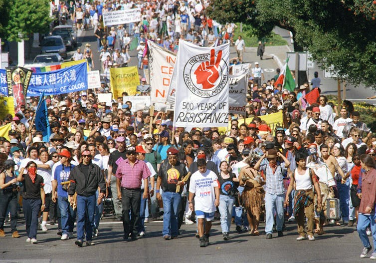
More and more towns and cities across the country are electing to celebrate Indigenous Peoples Day as an alternative to – or in addition to – the day intended to honor Columbus’ voyages.
Critics of the change see it as just another example of political correctness run amok – another flash point of the culture wars.
The growing recognition and celebration of Indigenous Peoples Day actually represents the fruits of a concerted, decades-long effort to recognize the role of indigenous people in the nation’s history.
Why Columbus?
Columbus Day is a relatively new federal holiday.
In 1892, a joint congressional resolution prompted President Benjamin Harrison to mark the “discovery of America by Columbus,” in part because of “the devout faith of the discoverer and for the divine care and guidance which has directed our history and so abundantly blessed our people.”
Europeans invoked God’s will to impose their will on indigenous people. So it seemed logical to call on God when establishing a holiday celebrating that conquest, too.
Of course, not all Americans considered themselves blessed in 1892. That same year, a lynching forced black journalist Ida B. Wells to flee her home town of Memphis. And while Ellis Island had opened in January of that year, welcoming European immigrants, Congress had already banned Chinese immigration a decade prior, subjecting Chinese people living in the U.S. to widespread persecution.
And then there was the government’s philosophy towards the country’s Native Americans, which Army Colonel Richard Henry Pratt so unforgettably articulated in 1892: “All the Indian there is in the race should be dead. Kill the Indian in him, and save the man.”
It took another 42 years for Columbus Day to formally become a federal holiday, thanks to a 1934 decree by President Franklin D. Roosevelt.
He was responding, in part, to a campaign by the Knights of Columbus, a national Catholic charity founded to provide services to Catholic immigrants. Over time, its agenda expanded to include advocacy for Catholic social values and education.
When Italians first arrived in the United States, they were targets of marginalization and discrimination. Officially celebrating Christopher Columbus – an Italian Catholic – became one way to affirm the new racial order that would emerge in the U.S. in the 20th century, one in which the descendants of diverse ethnic European immigrants became “white” Americans.
To some, recognition of Columbus was a way to welcome Italian Americans into the fold of mainstream American culture.AP Photo/Jeff Chiu
Indigenous people power
But some Americans started to question why Indigenous people – who’d been in the country all along – didn’t have their own holiday.
In the 1980s, Colorado’s American Indian Movement chapter began protesting the celebration of Columbus Day. In 1989, activists in South Dakota persuaded the state to replace Columbus Day with Native American Day. Both states have large Native populations that played active roles in the Red Power Movement in the 1960s and 1970s, which sought to make American Indian people more politically visible.
Then, in 1992, at the 500th anniversary of Columbus’ first voyage, American Indians in Berkeley, California, organized the first “Indigenous Peoples’ Day,” a holiday the city council soon formally adopted. Berkeley has since replaced its commemoration of Columbus with a celebration of indigenous people.
The holiday can also trace its origins to the United Nations. In 1977, indigenous leaders from around the world organized a United Nations conference in Geneva to promote indigenous sovereignty and self-determination. Their first recommendation was “to observe October 12, the day of so-called ‘discovery’ of America, as an International Day of Solidarity with the Indigenous Peoples of the Americas.” It took another 30 years for their work to be formally recognized in the United Nations Declaration on the Rights of Indigenous Peoples, which was adopted in September 2007.
Unexpected allies
Today, cities with significant native populations, like Seattle, Portland and Los Angeles, now celebrate either Native American Day or Indigenous Peoples Day. And states like Hawaii, Nevada, Minnesota, Alaska and Maine have also formally recognized their Native populations with similar holidays. Many Native governments, like the Cherokee and Osage in Oklahoma, either don’t observe Columbus Day or have replaced it with their own holiday.
Maine Gov. Janet Mills speaks at the signing ceremony to officially replace Columbus Day with Indigenous Peoples’ Day.AP Photo/Robert F. Bukaty
But you’ll also find commemorations in less likely places. Alabama celebrates Native American Day alongside Columbus Day, as does North Carolina, which, with a population of over 120,000 Native Americans, has the largest number of Native Americans of any state east of the Mississippi River.
In 2018, the town of Carrboro, North Carolina, issued a resolution to celebrate Indigenous Peoples Day. The resolution noted the fact that the town of 21,000 had been built on indigenous land and that it was committed to “protect, respect and fulfill the full range of inherent human rights,” including those of indigenous people.
While Columbus Day affirms the story of a nation created by Europeans for Europeans, Indigenous Peoples Day emphasizes Native histories and Native people – an important addition to the country’s ever-evolving understanding of what it means to be American.
Rodney Lydell Hutchinson, 38, of Crestview, Florida, was arrested on Monday, October 12, 2020, in connection to an armed robbery at a home in Kelseyville, California. Lake County Jail photo. LAKE COUNTY, Calif. – Authorities have arrested a Florida man and are looking for other subjects who they said took part in an early Monday morning armed robbery in Kelseyville.
Rodney Lydell Hutchinson, 38, of Crestview, Florida was arrested later on Monday morning, according to Lt. Corey Paulich.
At 3 a.m. Monday, Lake County Sheriff’s Dispatch received a call from a female living in 10600 block of Bottle Rock Road in Kelseyville reporting that four male adults broke into her house, fired several shots and took marijuana from the residence, Paulich said.
The woman told authorities that after the robbery the subjects left the area in a white Sprinter-type van and a U-Haul truck. The victim reported that all four males were armed with handguns, Paulich said.
Responding deputies saw a U-Haul truck traveling north on Highway 29 near Highland Springs Road. Paulich said the deputies attempted to stop the U-Haul, but it continued on Highway 29 at 80 miles per hour. The deputies observed items being thrown from the truck in the area of Highland Springs Road.
The pursuit continued across the Nice-Lucerne Cutoff to Highway 20. Paulich said the U-Haul continued east on Highway 20 where officers from the California Highway Patrol joined the pursuit.
The pursuit continued on Highway 20 until it reached the area of the WorldMark Resort in Nice. Paulich said the U-Haul made a U-turn and as it did one of the vehicle’s occupants jumped out and fled towards the lake.
The U-Haul then drove west on Highway 20 turning into the resort. Paulich said the U-Haul slowed in the WorldMark parking lot and two more individuals jumped out, fleeing on foot while the U-Haul was still rolling.
He said the U-Haul eventually stopped after jumping a curb and crashing into a sign for the resort.
Officers pursued the subjects but lost sight of them in the resort. Paulich said officers were able to locate a male subject matching the subject’s description who was hiding under a staircase. The subject ran from the officers, going up to the second story and jumping off the second-story balcony.
Paulich said the male subject – later identified as Hutchinson – continued to run a short distance before surrendering to officers.
When questioned, Hutchinson told officers he was homeless and only ran because he had a warrant for his arrest out of Florida. Paulich said Hutchinson denied being one of the males that ran from the U-Haul.
Officers searched the U-Haul, locating several plastic containers and trash bags containing marijuana, Paulich said.
An officer from the Lakeport Police Department had also responded to assist, locating items that had been thrown out of the U-Haul during the pursuit. Paulich said officers were able to locate handguns, cell phones and gloves.
Hutchinson was arrested and booked at the Lake County Jail on charges of robbery, assault with a firearm, evading, felon in possession of a firearm, carrying a loaded firearm and conspiracy. Paulich said Hutchinson remained in custody on Tuesday with bail set at $150,000.
The Sheriff’s Major Crimes Unit responded and continued the investigation, Paulich said.
The Sheriff’s Office is asking anyone with information regarding this investigation and the identity of the outstanding subjects involved in the robbery to contact Det. Jeff Mora at 707-262-4224.
The Glass fire, shown here at 67,484 acres. Map courtesy of Cal Fire. LAKE COUNTY, Calif. – Fire crews are within striking distance of having the Glass fire fully contained, while thousands of firefighters continue their work to control the August Complex.
On Monday night, the Glass fire remained at 67,484 acres, with containment at 96 percent, Cal Fire reported.
The incident, expected to be fully contained on Oct. 20, has been burning in Napa and Sonoma counties since Sept. 27, coming less than a mile from Lake County’s southern border.
Total structures that continued to be threatened by the incident were reduced again on Monday to 1,217, Cal Fire said.
Cal Fire’s final damage assessment, released late last week, said the Glass fire has destroyed 1555 structures and damaged 282 others.
On Monday night, resources that Cal Fire said remained assigned to the incident included 219 firefighters, 10 engines, seven water tenders, one helicopter, two hand crews and 10 dozers.
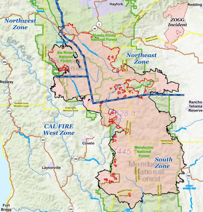
The August Complex as mapped on Monday, October 12, 2020. Map courtesy of the US Forest Service. Changes in weather could bring more fire activity in August Complex area
On California’s largest fire, the August Complex, by Monday night it had burned 1,029,029 acres on the Mendocino, Shasta-Trinity and Six Rivers National Forests, with containment up to 76 percent, the US Forest Service reported.
Officials said 4,610 personnel are assigned on all four zones of the complex, which has been burning since Aug. 17.
The Forest Service said firefighters continue to coordinate with Cal Fire on control measures in the Hellhole Canyon area, northeast of Covelo.
On the west and south sides of the South Zone, which includes portions of the Mendocino National Forest in northern Lake County, fire crews are felling hazard trees along roadways as needed for firefighters and public safety. Crews continue to patrol firelines by ground and air, officials said.
The Forest Service said smoke may be visible in areas where pockets of vegetation within the fire’s perimeter continue to burn and temperatures warm up over the next few days.
On the west side of the South Zone, the Forest Service said firefighters are repairing handline constructed on the southwestern portion of the fire during suppression operations. Firefighters continue to scout for additional opportunities for suppression repair.
Changes in the weather this week could lead to challenges for firefighters.
The Forest Service said relative humidity is expected to drop after the moist weekend with an increase in afternoon winds that have the potential to dry out fuels and increase fire activity along ridges and slopes. The dry weather is expected to continue through the week, with generally northerly breezes.
Email Elizabeth Larson at This email address is being protected from spambots. You need JavaScript enabled to view it.. Follow her on Twitter, @ERLarson, or Lake County News, @LakeCoNews.
The August Complex-South area soil burn severity map, courtesy of the US Forest Service. NORTHERN CALIFORNIA – Burned Area Emergency Response, or BAER, specialists recently completed their data gathering and verification fieldwork of the August Complex-South burn area.
Across all of its zones, the August Complex was up to 1,028,601 acres burned and 75 percent contained as of Sunday night, according to the US Forest Service.
Officials said the soil burn severity map has been finalized. Soil burn severity levels are unburned/very low, low, moderate and high.
The map shows that in the August Complex-South fire area, approximately 52 percent of the 521,256 acres analyzed by the BAER team is either unburned/very low (9%) or low (43%) soil burn severity, while 44 percent sustained a moderate soil burn severity, and only 4 percent burned at high soil burn severity.
Of the land assessed, 416,301 acres, or 79.9 percent, is owned by the Forest Service, 90,288 acres or 17.3 percent is held by other owners, 14,660 acres or 2.8 percent is owned by the Bureau of Land Management and 7 acres, less than 1 percent, covers other federal lands.
The BAER post-fire assessment team uses soil burn severity data to identify if there are areas of concern where increased soil erosion, accelerated surface water run-off, and debris flows have the potential to impact human life/safety, property, and critical natural and cultural resources from storm events.
The team consists of Forest Service scientists and specialists who are considering emergency stabilization options for those critical resources on National Forest System lands.
The BAER team shares it analysis and findings with interagency cooperators who work with private land and business owners to help them prepare for upcoming rain events.
BAER Team Leaders Luke Rutten and Kendal Young said, “The BAER team expects erosion and run-off within the August Complex-South fire area to moderately increase as a result of the fire because 48 percent of the burned area experienced moderate or high soil burn severity.”
In specific areas that experienced moderate to high soil burn severity, there is concern for increased post-fire run-off from steep hillslopes and resultant increases in post-fire soil erosion and debris flows.
The August Complex-South soil burn severity BAER map, shown above, can be downloaded at the interagency August Complex Post-Fire BAER InciWeb site as a JPEG or PDF version under the “maps” tab.

 How to resolve AdBlock issue?