LAKE COUNTY, Calif. — The Lakeport City Council is set to consider raising water and sewer rates for city residents, as well as approval of a lease for a portion of the Carnegie Library.
The council will meet at 6 p.m. Tuesday, Oct. 19, in the council chambers at Lakeport City Hall, 225 Park St.
The council chambers will be open to the public for the meeting. In accordance with updated guidelines from the state of California and revised Cal OSHA Emergency Temporary Standards, persons who are not fully vaccinated for COVID-19 are required to wear a face covering at this meeting.
If you cannot attend in person, and would like to speak on an agenda item, you can access the Zoom meeting remotely at this link or join by phone by calling toll-free 669-900-9128 or 346-248-7799.
The webinar ID is 973 6820 1787, access code is 477973; the audio pin will be shown after joining the webinar. Those phoning in without using the web link will be in “listen mode” only and will not be able to participate or comment.
Comments can be submitted by email to This email address is being protected from spambots. You need JavaScript enabled to view it.. To give the City Clerk adequate time to print out comments for consideration at the meeting, please submit written comments before 3:30 p.m. on Tuesday, Oct. 19.
Indicate in the email subject line "for public comment" and list the item number of the agenda item that is the topic of the comment. Comments that are read to the council will be subject to the three minute time limitation (approximately 350 words). Written comments that are only to be provided to the council and not read at the meeting will be distributed to the council before the meeting.
The council will meet new Lakeport Police Officer Katie Hutchins and present a proclamation designating October 2021 Domestic Violence Awareness Month.
On the agenda is a public hearing during which the council will receive written protests of the proposed rates, to be followed by adoption of resolutions to establish new water and wastewater rates to go into effect on Nov. 1.
Based on the proposed increases, over five years, an average single-family residential water customer with a monthly flow of 800 cubic feet has an existing bill of $53.09 would see their costs increase to $71.49 by the fifth year for water, and would go from $74.25 to $86.05 over that time period for water.
In other business, City Manager Kevin Ingram will take to the council a proposed one-year lease with the Clear Lake Environmental Research Center, or CLERC, for the reuse of the Carnegie Library building for the development of an environmental research center and associated labs and offices.
The proposed lease calls for the nonprofit to pay $850 a month for the use of the building. The city will cover the costs of electricity, water, sewer and trash.
“As the building has not been utilized in several years it is not clear what the true costs for utilities at this site are at this time. Both the City and CLERC have agreed to revisit the allocation of costs prior to the expiration of the lease term once the parties have data on the actual costs associated with CLERC’s use of the building,” Ingram said in his report.
Also on Tuesday, Police Chief Brad Rasmussen will ask the council to approve a Crisis Intervention Responder Program and authorize him and the city manager to finalize details and sign a memorandum of understanding with Lake Family Resource Center.
On the consent agenda — items usually accepted as a slate on one vote — are ordinances; minutes of the regular council meeting on Oct. 5; and approval of the side letter agreement with the Unrepresented Employees Compensation and Benefits Program adopted Sept. 7, 2021.
Email Elizabeth Larson at This email address is being protected from spambots. You need JavaScript enabled to view it.. Follow her on Twitter, @ERLarson, or Lake County News, @LakeCoNews.
LAKE COUNTY, Calif. — The Westside Community Park Committee is asking community members to participate in a survey to select their favorite plan for a new horse park.
The committee is pursuing a $3 million grant from the state’s Proposition 68 Regional Parks Program.
As part of that process, the committee held four community planning meetings, resulting in three proposed plans for the horse park they plan to build on Highway 175, just west of Lakeport.
Descriptions of the plans and pictures of each are published below.
Click on this link to participate in the survey and give input on the preferred plan.
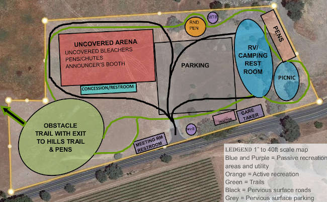
Horse Park — Map A
Map A includes two arenas, one covered, one uncovered.
The covered arena, 130 by 200 feet, with a tilled dirt floor, open bleachers on the west end, and horse pens on the north side, is designed to be used by riders and drivers year-round. The roof would have solar to offset utility expenses.
An uncovered arena, 130 by 200 feet, with a tilled dirt floor, can accommodate riders, drivers, and a junior rodeo with three bucking chutes and stock pens, an announcer’s booth overhead, roping chutes, and fencing to move animals.
Bleachers would be on the south side of each arena, with restrooms and a concession stand in between.
There are two round pens and a large obstacle course for horse and horsemanship training. A meeting room for educational and social activities is located adjacent to the parking area.
Overnight camping is under the trees along with covered picnic tables and barbecues. The caretaker home is nearby and handy to the entrance.
There is a perimeter riding/driving/hiking trail, and a gate on the west boundary that leads to a 4-plus mile loop trail in the nearby hills.
The tractor shed is convenient to both arenas and the obstacle area. The well is at the bottom of the hill and the water tank is at the highest point on the property.
There is an emergency exit on the northeast edge of the property (if permitted) to provide a second access to Highway 175.
Horse Park — Map B
Map B includes an uncovered arena, 150 by 328 feet, that can be used by riders and drivers and can offer a PRCA rodeo.
It has stock pens on the west end, bucking and roping chutes on the north side, and fencing to move animals. Uncovered bleachers run along the south side, with restrooms and concession stands behind or under them.
A road circles the arena to deliver rough stock for rodeo events and accommodate emergency vehicles.
There is an obstacle course and a round pen for horse and horsemanship training, and a meeting room (with restroom) for educational and social activities.
Overnight camping under the trees includes restrooms with showers, and a picnic ground with covered tables and barbecues. The camping area would be used exclusively for competitor parking during rodeo events.
There is a perimeter riding/driving/hiking trail, and a gate to the west that leads to a 4-plus mile loop trail in the nearby hills.
The caretaker house, tractor shed, and well are located between the entrance and the camping area.
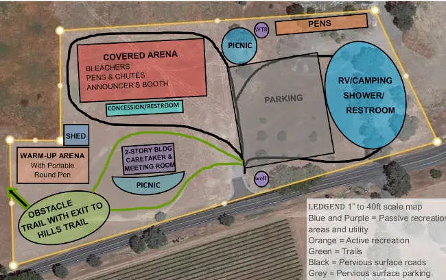
Horse Park — Map C
Map C includes a 150 by 328 foot Covered Arena, with tilled earth footing, designed for riding, driving, and PRCA rodeos.
It has covered bleachers on both the north and south sides, an announcer’s booth above the six bucking chutes and six stock pens on the west side, roping chutes on the east side, and fencing along the south side for moving stock to the east chutes.
A road circles the arena to deliver rough stock for rodeo events and accommodate emergency vehicles.
There is a 30-foot by 45-foot warmup arena with a portable round pen, and an obstacle course for horse and horsemanship training. The tractor shed is located nearby for convenience.
One level of a two-story building provides a two bedroom, two bath caretaker home, the other level provides a meeting room for educational and social activities.
Separate covered (circle) and uncovered (moon) picnic grounds have tables and barbecues. Overnight camping is located under mature trees, with restrooms and showers. The camping area would be used exclusively for competitor parking during rodeo events.
There is a perimeter riding/driving/hiking trail, and a gate on the west boundary that leads to a 4-plus mile loop trail in the hills to the west.
The well is located at the lowest point on the property and the water tank is located higher, at the north edge of the property.
LAKE COUNTY, Calif. — The Lake County Registrar of Voters Office has completed the official canvass for last month’s special gubernatorial recall election and will present the final results to the Board of Supervisors on Tuesday.
The special election seeking Gov. Gavin Newsom’s recall took place on Sept. 14. It was the 54th unsuccessful recall attempt against a governor since 1913.
The official canvass must be completed within a month, and Registrar of Voters Maria Valadez completed her work on Thursday, as planned.
The results will be certified by Oct. 22, the Secretary of State’s Office reported.
Valadez will ask the supervisors to adopt a resolution accepting the official canvass and accept her certification of the election results, which will be taken up as part of the consent agenda.
The final results for Lake County showed that there was a 59.59% percent voter participation rate, with 22,388 ballots cast over 70 precincts. There are 37,571 registered voters in the county.
The ballots cast in favor of recalling Gov. Newsom totaled 10,923, or 49%, while the no votes totaled 11,367, or 51%.
That’s compared with the initial count given on the night of Sept. 14, when the early returns looked far more lopsided.
The preliminary results on that night showed a 62.48% “no” vote compared to a 37.52% “yes” vote, as Lake County News has reported. At that point 9,333 of the 22,388 ballots had been counted, accounting for 41% of the total vote.
In a breakdown of vote-by-mail or absentee ballots, the yes vote was 47.06%, or 9,647 ballots, to 10,851 no votes, or 52.94%.
Of those ballots cast on Election Day, 71.21%, or 1,276 ballots, supported the recall, while 516 ballots, or 28.79%, voted against the recall.
The top five candidates who received votes to succeed Newsom had he been recalled were led in Lake County by Larry Elder, with 6,306 votes; John Cox, 1,060 votes; Kevin Kiley, 801 votes; Kevin Paffrath, 642 votes; and Patrick Kilpatrick, 548 votes.
While Lake County’s final results were markedly different from the preliminary count, on a statewide basis, the statewide results changed slightly.
Early on Sept. 15, the California Secretary of State’s Office reported that the preliminary statewide count was 63.9% against the recall and 36.1% in support of it.
On Friday, the Secretary of State’s Office said the statewide results were 61.9% against the recall and 38.1 percent for it.
Statewide, in the top five Elder also led alternate candidates, followed by Paffrath, Kevin L. Faulconer, Brandon M. Ross and Cox.
Email Elizabeth Larson at This email address is being protected from spambots. You need JavaScript enabled to view it.. Follow her on Twitter, @ERLarson, or Lake County News, @LakeCoNews.
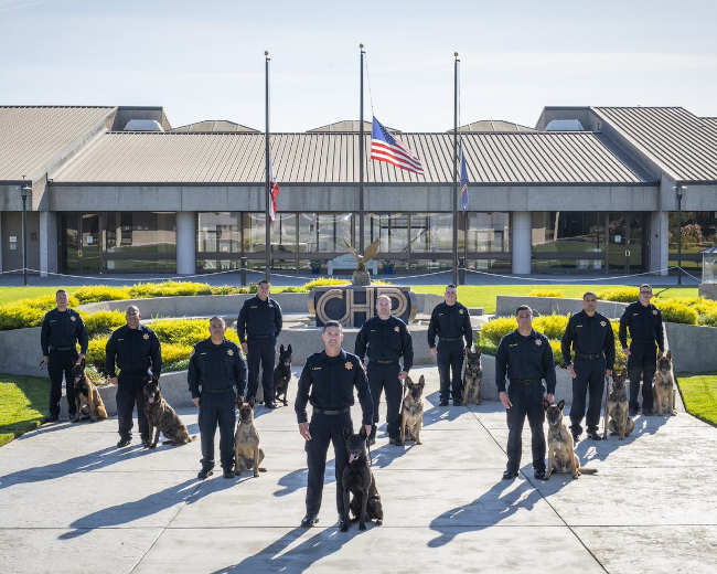
Ten new K-9 teams that graduated from the California Highway Patrol’s Academy on Friday, October 15, 2021. Photo Credit: CHP Senior Photographer Michael Wong. The California Highway Patrol announced the graduation and deployment of its 10 newest K-9 teams on Friday.
The ceremony at the CHP Academy in West Sacramento is the culmination of 400 to 600 hours of intense training for each officer and their canine partner.
“After weeks of rigorous training, these new teams are ready to assist in the CHP’s mission of protecting and serving the State of California,” said CHP Commissioner Amanda Ray. “Our canines are a tremendous asset to the department, and the addition of these 10 teams to our existing resources will supplement the already highly effective canine program.”
The CHP uses its canines to perform a variety of functions, including detecting human scent, contraband, and explosives.
A canine team can improve the safety and effectiveness of officers as well as saving time and money.
The CHP canines are also used to assist allied agencies in apprehending criminals, detecting explosives or drugs, and in locating “at-risk” missing persons.
This is the only graduation in 2021 for CHP canine teams trained in handler protection and narcotics detection or handler protection and explosive detection.
The canine teams completed between 11 and 15 weeks of intensive training at the CHP Academy, depending on their specialty.
All handlers are CHP officers with departmental experience ranging from four to 15 years.
The graduating canine teams represent the following CHP Divisions: Valley, Golden Gate, Central, Southern, Border and Inland.
Following this graduation, the CHP now has 48 canine teams deployed throughout the state.
K-9 Tyson, a Dutch shepherd assigned to Southern Division, wearing a protective vest. Photo Credit: CHP Senior Photographer Michael Wong.
Susan Kocher, University of California, Division of Agriculture and Natural Resources and Ryan E. Tompkins, University of California, Division of Agriculture and Natural Resources
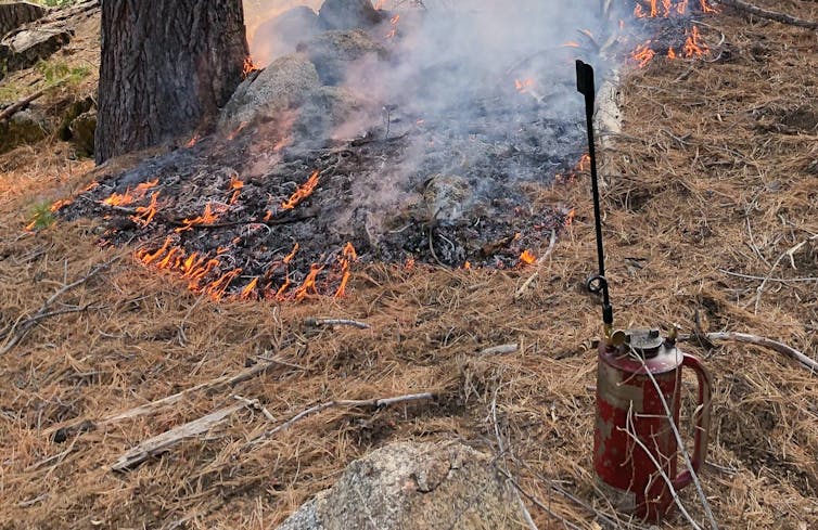
Tools for a prescribed burn conducted in the Sierra Nevada in November 2019. Susan Kocher, CC BY-ND
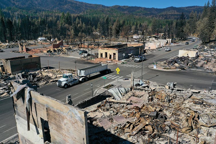
Californians have been concerned about wildfires for a long time, but the past two years have left many of them fearful and questioning whether any solutions to the fire crisis truly exist.
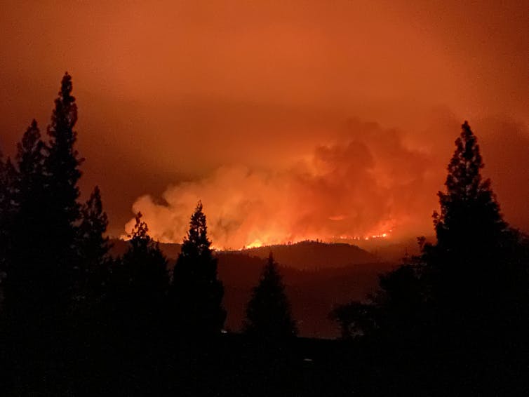
The Dixie Fire in the Sierra Nevada burned nearly 1 million acres in 2021, including almost the entire community of Greenville. Then strong winds near Lake Tahoe sent the Caldor Fire racing through the community of Grizzly Flats and to the edges of urban neighborhoods, forcing the evacuation of tens of thousands of people – including one of us. Those were only the biggest of the 2021 fires, and the risk isn’t over. A wind-blown fire that started Oct. 11 was spreading quickly near Santa Barbara on the Southern California coast.
As foresters who have been working on wildfire and forest restoration issues in the Sierra Nevada for over a quarter of a century, we have found it painful to watch communities destroyed and forests continuing to burn to a crisp.
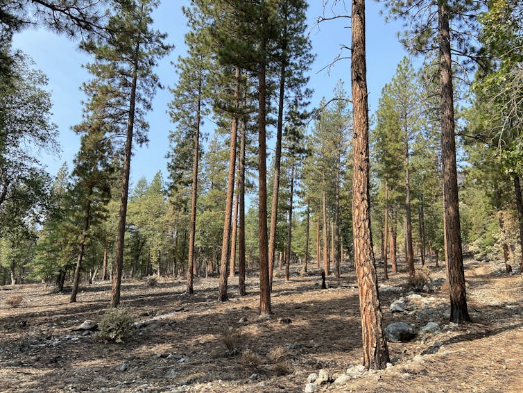
The main lesson we gather from how these fires have burned is that forest fuels reduction projects are our best tools for mitigating wildfire impacts under a changing climate, and not nearly enough of them are being done.
Thinned areas like this one in California’s Genessee Valley were more resistant to 2021’s Dixie Fire.Ryan Tompkins, CC BY-ND
Two historic policies, in our view, led the western U.S. to the point where its forests have become so overgrown they’re fueling megafires that burn down whole communities.
Fire suppression
The first policy problem is fire suppression and exclusion.
Fire is an essential ecological process, and many of the ecosystems in the West are adapted to frequent fire, meaning plant and wildlife species have evolved to survive or even thrive after wildfires. But most people arriving in California during colonization, both before and after the Gold Rush of 1849, fundamentally misunderstood the nature of frequent fire forests.
As state and federal agencies evolved policies on forest management, they considered all fire to be an existential problem and declared war. The U.S. Forest Service kicked off a century of fire suppression in the West after the devastating fires of 1910, known as the “Big Blowup” or “Big Burn,” by implementing the 10 a.m. policy. It aimed for full suppression of all fires by 10 a.m. the day after they broke out.
The second policy issue is the regulatory approach that grew out of past logging practices.
Foresters and early California communities were interested in forests for lumber and fuel wood. They sent the largest – and most fire-tolerant – trees to mills to be turned into lumber, which was used to build California’s cities and towns.
Poorly executed logging in some areas led to concerns from residents that forest cover and habitat was shrinking. As a result, state and federal regulations were developed in the 1970s that require managers proposing forest projects to consider a “no action alternative.” In other words, maintaining dense forest habitat in the long term was considered a viable management choice.
On private land, few owners today thin the forest to levels that would mimic the more fire-resilient forests found in the Sierra at colonization. The California Forest Practices Act until recently required replanting after timber harvest to levels much more dense than were found at colonization. In other words, our current regulatory framework promotes maintaining high levels of forest density, when much more drastic removal of vegetation is needed.
Taken together, these policies have promoted 21st-century forests that are younger, denser and more homogenous – making them vulnerable to increasingly severe disturbances such as drought, insect outbreaks and fire. This new reality is exacerbated by a changing climate, which turns the regulatory assumption that active and widespread forest management is riskier than no management on its head.
Agency priorities change as the crisis grows
Just as forests have changed, so too have the agencies that manage and regulate them. The U.S. Forest Service has seen its budgets for fighting fires balloon while its capacity to proactively manage forests has been shrinking. The California Department of Forestry and Fire Protection, known as CAL FIRE, has also seen large increases in firefighting budgets, though the state legislature has recently moved to increase fire prevention funds, too.
Living in communities threatened by wildfires this summer, we are very grateful to firefighters who have saved our homes. Yet we also are concerned that more large, high-severity wildfires burning across the landscape mean less funding and staff will be available for proactive fuels reduction projects like forest thinning and prescribed fires.
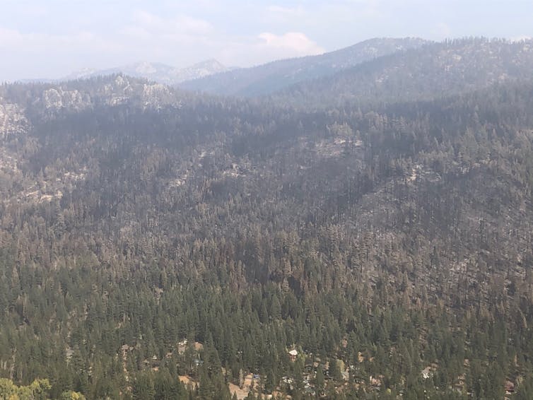
The Caldor Fire burned on both sides of Christmas Valley, but was stopped from burning into the community by firefighters using areas where fuels were reduced before the blaze.Susie Kocher, CC BY-ND
Both fires burned less severely in areas with proactive forest restoration and fuels management projects, including near South Lake Tahoe and near Quincy.
Fuels reduction projects include thinning out trees, burning off woody debris and reducing “ladder fuels” like small trees and brush that can allow fire to reach the tree canopy. They create more open forests that are less likely to fuel severe megafires. They also create strategic areas where firefighters can more easily fight future blazes. And, because fires burn less intensely in thinned forests, they leave more intact forest after a fire for regenerating new trees and sequestering carbon. Prescribed fires and managed ignitions paid huge dividends for containing the Dixie and Caldor fires.
During the Dixie Fire, firefighters used an area that had been strategically thinned in the past to set backfires to prevent the wildfire from spreading into the community of Quincy.Ryan Tompkins, CC BY-ND
To manage fires in an era of climate change, where drier, hotter weather creates ideal conditions for burning, experts estimate that the area treated for fuels reduction needs to increase by at least an order of magnitude. We believe government needs to accomplish these four things to succeed:
1) Drastically increase funding and staff for agencies’ fuels reduction projects, as well as outreach, cost-sharing and technical assistance for private forestland owners. Although the Biden administration’s proposal for a Civilian Climate Corps proposes funding to bring in more young and unskilled workers, funding more federal and state agency positions would recruit more natural resource professionals, provide career-track opportunities and better add forest restoration capacity for the long term.
2) Reduce regulations on forest and fuels management efforts for both public and private land. While California and the federal government have made recent strides to streamline regulations, land management agencies need to acknowledge the biggest risk in frequent fire forests is doing nothing, and time is running out. Agencies need to drastically cut the time needed to plan and implement fuels reduction projects.
3) Invest in communities’ capacity to carry out local forest restoration work by providing long-term support to local organizations that provide outreach, technical assistance and project coordination services. Funding restoration through competitive grants makes development of long-term community capacity challenging at best.
4) Provide funds and financial incentives for at risk communities to retrofit homes to withstand wildfires and reduce fuels around homes, communities and infrastructure.
Under a changing climate, we will have to learn to coexist with wildfires in the U.S. West, but this will require concerted action and a cultural shift in how we view and manage our forests and communities to be resilient.
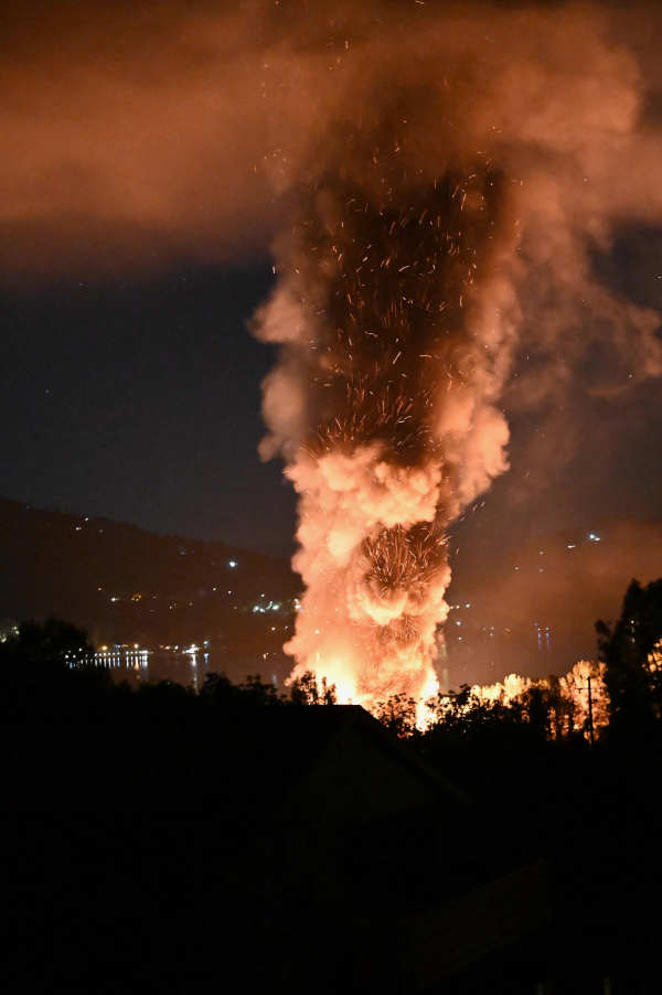
A multiple structure fire in Kelseyville, California, on Saturday, October 16, 2021. Photo by C. Spangler. LAKE COUNTY, Calif. — Firefighters worked early Saturday to contain a fire involving several structures in the Kelseyville area.
Shortly after 2:45 a.m., several structures were reported to be on fire at 9495 Konocti Bay Road, near Richmond Park Bar & Grill.
Firefighters arriving on scene reported that there were two motor homes fully involved, with a third trailer becoming involved a short time later, according to radio traffic.
The fire also was reported to have moved into nearby vegetation.
The Northshore Fire Support Team was requested to respond to the scene.
Incident command asked for Pacific Gas and Electric to respond, as well as asking for a hand crew.
Just before 4:15 a.m., the fire was reported to be confined to the structures, with firefighters working on the vegetation fire.
Firefighters were expected to be on scene until later in the morning for mop up.
Additional information will be published as it becomes available.
Email Elizabeth Larson at This email address is being protected from spambots. You need JavaScript enabled to view it.. Follow her on Twitter, @ERLarson, or Lake County News, @LakeCoNews.
As the fight against COVID-19 continues, the California Department of Public Health is urging Californians to get vaccinated against the flu now to protect themselves and their loved ones.
“In the midst of a COVID-19 pandemic, a severe flu season could be devastating for California,” said Dr. Tomás J. Aragón, director of the California Department of Public Health and State Public Health Officer. “Getting a flu shot is a safe and simple thing we can all do to keep people out of the hospital and reduce the strain on our health care system.”
In California, flu season is October through May and flu activity usually begins to increase in late November or December. It takes a couple of weeks after vaccination for the body to build immunity.
Getting vaccinated now before the flu season ramps up is the best time to protect yourself, your family and your community, officials said.
CDPH recommends the annual flu vaccination for everyone six months of age and older. Getting vaccinated against the flu is particularly important for people at high-risk of severe disease and hospitalization, including:
— People 65 years and older. — People who smoke or have underlying medical conditions like diabetes, heart disease, asthma, lung disease, neurologic disorders and weakened immune systems. — Pregnant women and children under five years of age. — Caregivers and residents in long-term care facilities. — Essential workers who encounter others outside their homes or at higher risk because of their occupation.
CDPH encourages Californians to contact their health care provider, physician's office, or clinic about getting the flu vaccine. Adults may also get immunized at the pharmacy where they generally pick up their prescriptions. Pharmacies accept most insurance, including Medi-Cal.
Some local health departments may offer low- or no-cost flu immunizations. If you still haven’t had the COVID-19 vaccine or are due for a booster, the flu vaccine and COVID-19 vaccine can be given on the same day.
Besides getting immunized, you can also take everyday preventive actions to stop the spread of germs:
— Continue to wear a mask. — Stay away from people who are sick and stay home when you or other family members are sick for at least 24 hours after symptoms go away before you are around others. — Cough or sneeze into your elbow, arm, or disposable tissue. If you use disposable tissue, use hand sanitizer, or wash your hands afterwards. — Wash hands frequently and thoroughly with soap and warm water or use an alcohol-based hand sanitizer. — Avoid touching your eyes, nose, and mouth.
For more information about the flu, visit CDPH's website.
LAKE COUNTY, Calif. — Lake County Animal Care and Control has more new dogs waiting to go home with new families.
Dogs available for adoption this week include mixes of American bulldog, American Staffordshire terrier, Belgian malinois, Doberman, German shepherd, husky, Labrador Retriever, pit bull, Rottweiler, shepherd and terrier.
Dogs that are adopted from Lake County Animal Care and Control are either neutered or spayed, microchipped and, if old enough, given a rabies shot and county license before being released to their new owner. License fees do not apply to residents of the cities of Lakeport or Clearlake.
The following dogs at the Lake County Animal Care and Control shelter have been cleared for adoption (additional dogs on the animal control website not listed are still “on hold”).
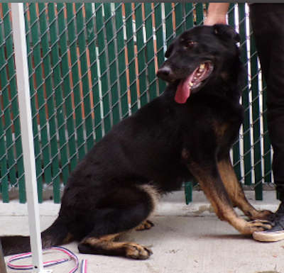
This 1-year-old female German shepherd is in kennel No. 4, ID No. LCAC-A-1767. Photo courtesy of Lake County Animal Care and Control. Female German shepherd
This 1-year-old female German shepherd has a short tan and black coat.
She is in kennel No. 4, ID No. LCAC-A-1767.
This 5-year-old female chocolate Labrador retriever-pit bull mix is in kennel No. 5, ID No. LCAC-A-1769. Photo courtesy of Lake County Animal Care and Control. Labrador-pit bull mix
This 5-year-old female chocolate Labrador retriever-pit bull mix has a short chocolate-colored coat.
She is in kennel No. 5, ID No. LCAC-A-1769.
“Ace” is a 1-year-old male shepherd and Doberman mix in kennel No. 6, ID No. LCAC-A-1731. Photo courtesy of Lake County Animal Care and Control. ‘Ace’
“Ace” is a 1-year-old male shepherd and Doberman mix with a short black and tan coat.
He is in kennel No. 6, ID No. LCAC-A-1731.
This 1-year-old male terrier is in kennel No. 7, ID No. LCAC-A-1782. Photo courtesy of Lake County Animal Care and Control. Male terrier
This 1-year-old male terrier has a long red coat.
He is in kennel No. 7, ID No. LCAC-A-1782.
“Duke” is a 1-year-old male pit bull mix in kennel No. 8, ID No. LCAC-A-1750. Photo courtesy of Lake County Animal Care and Control. ‘Duke’
“Duke” is a 1-year-old male pit bull mix with a short black and white coat.
He is in kennel No. 8, ID No. LCAC-A-1750.
This female shepherd-husky is in kennel No. 9, ID No. LCAC-A-1745. Photo courtesy of Lake County Animal Care and Control. Female shepherd-husky
This female shepherd-husky has a short tan coat with black markings and blue eyes.
She is in kennel No. 9, ID No. LCAC-A-1745.
This 1-year-old female shepherd-husky mix is in kennel No. 10, ID No. LCAC-A-1746. Photo courtesy of Lake County Animal Care and Control. Female shepherd-husky
This 1-year-old female shepherd-husky mix has a short tricolor coat and blue eyes.
She’s in kennel No. 10, ID No. LCAC-A-1746.
This 6-month-old male Belgian malinois puppy is in kennel No. 16, ID No. LCAC-A-1711. Photo courtesy of Lake County Animal Care and Control. Belgian malinois puppy
This 6-month-old male Belgian malinois puppy has a short tan coat.
He is in kennel No. 16, ID No. LCAC-A-1711.
This 1-year-old female Rottweiler is in kennel No. 18, ID No. LCAC-A-1700. Photo courtesy of Lake County Animal Care and Control. Female Rottweiler
This 1-year-old female Rottweiler has a short black coat with white markings.
She is in kennel No. 18, ID No. LCAC-A-1700.
“Rocky” is a 1-year-old female German shepherd mix in kennel No. 19, ID No. LCAC-A-1719. Photo courtesy of Lake County Animal Care and Control. ‘Rocky’
“Rocky” is a 1-year-old female German shepherd mix with a short black coat and tan markings.
She is in kennel No. 19, ID No. LCAC-A-1719.
This 2-year-old female German shepherd is in kennel No. 22, ID No. LCAC-A-1733. Photo courtesy of Lake County Animal Care and Control. Female German shepherd
This 2-year-old female German shepherd has a short black coat with tan markings.
She is in kennel No. 22, ID No. LCAC-A-1733.
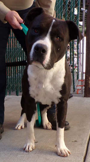
This 3-year-old female American Staffordshire mix is in kennel No. 23, ID No. LCAC-A-1727. Photo courtesy of Lake County Animal Care and Control. Female American Staffordshire mix
This 3-year-old female American Staffordshire mix has a short black coat with white markings.
She is in kennel No. 23, ID No. LCAC-A-1727.
This 1-year-old female husky-pit bull mix is in kennel No. 24, ID No. LCAC-A-1725. Photo courtesy of Lake County Animal Care and Control. Female husky-pit bull
This 1-year-old female husky-pit bull mix has a short brown coat with white markings.
She is in kennel No. 24, ID No. LCAC-A-1725.
This 1-year-old male husky-pit bull mix is in kennel No. 25, ID No. LCAC-A-1726. Photo courtesy of Lake County Animal Care and Control. Male husky-pit bull
This 1-year-old male husky-pit bull mix has a short coat.
He is in kennel No. 25, ID No. LCAC-A-1726.
“LuLu” is a 1-year-old female Rottweiler in kennel No. 27, ID No. LCAC-A-1658. Photo courtesy of Lake County Animal Care and Control. ‘LuLu’
“LuLu” is a 1-year-old female Rottweiler with a short black and tan coat.
She is in kennel No. 27, ID No. LCAC-A-1658.
This 2-year-old male shepherd mix is in kennel No. 28, ID No. LCAC-A-1743. Photo courtesy of Lake County Animal Care and Control. Male shepherd mix
This 2-year-old male shepherd mix has a short black and tan coat.
He is in kennel No. 28, ID No. LCAC-A-1743.
This young male pit bull is in kennel No. 29, ID No. LCAC-A-1699. Photo courtesy of Lake County Animal Care and Control. Male pit bull
This young male pit bull has a short black and white coat.
He is in kennel No. 29, ID No. LCAC-A-1699.
This 2-year-old female terrier mix is in kennel No. 30, ID No. LCAC-A-1739. Photo courtesy of Lake County Animal Care and Control. Female terrier mix
This 2-year-old female terrier mix has a short tan coat.
She is in kennel No. 30, ID No. LCAC-A-1739.
This 1-year-old female pit bull mix is in kennel No. 31, ID No. LCAC-A-1683. Photo courtesy of Lake County Animal Care and Control. Female pit bull
This 1-year-old female pit bull mix has a short gray coat with white markings.
She is in kennel No. 31, ID No. LCAC-A-1683.
“Dozer” is a 5-year-old American pit bull terrier mix in kennel No. 33, ID No. LCAC-A-1483. Photo courtesy of Lake County Animal Care and Control. ‘Dozer’
‘Dozer’ is a 5-year-old American pit bull terrier mix with a short brindle coat.
He is in kennel No. 33, ID No. LCAC-A-1483.
“Milo” is a 3-year-old male American bulldog-pit bull mix in kennel No. 34, ID No. LCAC-A-1657. Photo courtesy of Lake County Animal Care and Control. ‘Milo’
“Milo” is a 3-year-old male American bulldog-pit bull mix with a short white coat.
He is in kennel No. 34, ID No. LCAC-A-1657.
Email Elizabeth Larson at This email address is being protected from spambots. You need JavaScript enabled to view it.. Follow her on Twitter, @ERLarson, or Lake County News, @LakeCoNews.
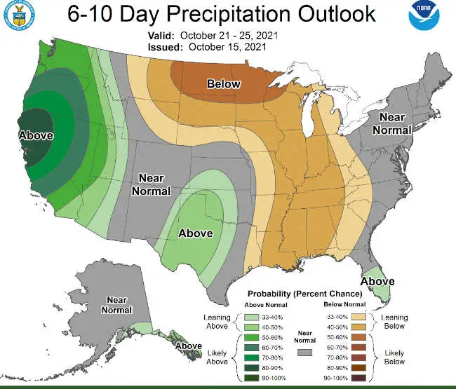
The Climate Prediction Center’s outlook for Oct. 21 to 25, 2021, shows above-normal precipitation for areas of Northern California including Lake County. LAKE COUNTY, Calif. — The National Weather Service is forecasting chances of rain over the weekend and into next week.
The Climate Prediction Center’s precipitation outlook for Oct. 21 to 25, which was issued on Friday, calls for above-normal precipitation for areas of Northern California that include Lake County.
The center’s forecast estimates next week’s rainfall could be 90 to 100% above normal.
The National Weather Service’s Eureka office said the below-normal precipitation for the first half of October could be made up for in the last two weeks of the month if the Climate Prediction Center’s predictions hold true.
The Lake County forecast calls for chances of rain Sunday and into Sunday night, totaling a fifth of an inch.
Conditions are expected to clear on Monday and Tuesday, with rain likely beginning on Wednesday and continuing through Friday, the forecast said.
On Saturday, temperatures are expected to range from the high 70s to low 80s before dropping into the 60s on Sunday, when rain is expected.
Through Friday, daytime temperatures are expected to range from the high 50s and 60s along the Northshore to the 70s in the south county. Nighttime conditions will be in the high 30s to the high 40s.
Email Elizabeth Larson at This email address is being protected from spambots. You need JavaScript enabled to view it.. Follow her on Twitter, @ERLarson, or Lake County News, @LakeCoNews.
How do I get information about the water level of the lake? Is the lake at the lowest that it has ever been? How low will the lake get this year and what is predicted for rain this winter?
Thanks!
From “Learning about Lake Levels!” Lorne
Lakeport’s Fifth Street Ramp is still operational and open even + lower water levels at or near -2.0 Rumsey. Photo by Angela De Palma-Dow. Dear Lorne,
This is a great set of questions Lorne! Also, you are not the only one who has asked about lake levels. Clear Lake’s water level is very low right now, exposing large areas of shoreline and sediment, some that have not been this dry and exposed for decades!
During the drought this year, the low lake level is a concern for many who live on the lake and see the declining edge of the water. Regardless if you are a fisherperson, a shoreline property owner or renter, or enjoy recreation like wake surfing or kayaking, less water in the lake is of extreme interest to many. Being aware of the lake level is fairly easy to do.
Measuring lake levels
Daily lake level data is measured from an in-lake gauge (#11450000) operated and maintained by the United States Geological Survey (USGS).
The gauge has historically been located on a pier at Lake County Vector Control District in Lakeport, but due to the recent drought conditions and lack of water depth at the gauge’s normal location, the gauge was temporarily moved to the Fifth Street ramp at Library Park in Lakeport.
The move caused a few swings of up and down lake level readings during the week around Oct. 7, but as of Oct. 15, the measurements have stabilized. However, the USGS maintains that all online data is provisional until verified and confirmed and usually that can take several months.
Note: The vernacular use of “gage” and “gauge” can be used interchangeably and both can be used as a verb or a noun. The USGS has a historical affinity for the use of “gauge” and according to Merriam-Webster Dictionary, considering global use, “gauge” is the preferred variant of this word and is used more commonly then “gage.” If you ask the Lady of the Lake, life is too short to gage your success by the amount and type of gauges being counted, but don’t mind me and pick the gauge/gage that is right for you!
Gauge relocation and replacement is not a new thing, in fact it has happened many times over the history of USGS monitoring Clear Lake water levels.
For example, prior to 1984, the gauge was located on the public pier on third street in Lakeport, then moved to a private pier a few blocks south. The gauge at that time was non-recording, meaning it didn’t log data, someone had to go out and write down the measurement in a log book. Now the gage measures, stores, and transmits data to USGS satellite and the data quickly makes its way to the gage website.
Then in 1984, the gage was moved to its current permanent home at Lake County Vector Control District on Esplanade in Lakeport. Throughout the years the gage has been adjusted, replaced, repaired and upgraded, and some years during extreme droughts or floods it’s temporarily relocated for better access or to ensure more accurate measurements.
It makes sense that Vector Control would be good partners for a lake gage as low and high water levels influence habitat availability for mosquitos. Also, believe it or not, before the internet, folks would call into the Vector Control District and ask for the current lake levels; now they are simply a few clicks away on your computer or smartphone!
Figure. Lake Level data for the period of Jan. 1 to Oct. 14, 2021 (blue) compared to historic median (middle value) for the last previous 101 years. Source: USGS. If you wanted to know stage height data from other gauges around the state, I suggest you explore the Sierra Nevada River Forecast Network Interactive Map. On this site, you can find different lakes or rivers with real-time gages measuring lake levels, stream height and stream flow.
Also, the Lake County Water Resources Department monitors the daily lake level and can provide that to you by phone 707-263-2344, if you do not have access to the website.
How lake level is determined
Clear Lake is different then every other lake, reservoir or water body out there when it comes to the lake level measurement method.
Clear Lake uses the “Rumsey Gage” unit of measurement. This measurement was established by Captain Rumsey in 1873. The measurement was derived from the natural levels of the lake as determined by the Grisby Riffle, with a range between zero and 7.56 feet Rumsey, which is the natural low and high levels of the lake.
For example, the low level at “zero rumsey” is the point at which water is too low to pass the Riffle and flow down Cache Creek; it’s the “natural low” level of the lake.
Grigsby Riffle, during normal flow years this formation regulates the amount of water that can leave Clear Lake through Cache Creek. Photo courtesy of Lake County Water Resources. Unlike reservoirs, Clear Lake’s water level is naturally controlled by the Grigsby Riffle. The Grigsby Riffle is a naturally formed rock gravel formation at the confluence of Cache Creek and Seigler Creek; this spot can be easily observed from the Lake Street Bridge in Lower Lake.
The combination of elevation, gravel accumulation and creek bed constriction physically limits the maximum amount of water that can pass through from the lakeside downstream to the rest of Cache Creek.
There is a court-ordered “Bemmerly Decree” (1940) that prohibits the excavation or alteration of the Riffle, meaning that no one is allowed to build up or tear down the riffle which maintains the water level in Clear Lake from leaving “too fast” down Cache Creek.
You may notice this phenomenon during flood years, where even though the Cache Creek dam (located 3 miles downstream Cache Creek) is fully open, the amount of water flowing through is the same. The gravel impoundment, stream shape and stream bottom elevation of the Grisby Riffle is literally controlling the amount of water that can leave and flow out of the lake. This is the bottleneck point.
Many think the Cache Creek dam, managed by Yolo County, is open all the time and allowing “all the water to flow from the lake”; but in fact most of this current drought year Cache Creek above and around the Grisby Riffle has been dry — for months water has not been flowing out of Clear Lake down through Cache Creek.
There is a base flow of water that does flow downstream from Cache Creek to Yolo County, but the amounts of Clear Lake water allowed to be actively “taken” from the lake to Yolo are regulated naturally and legally.
The other court-ordered decrees, the Gopcevic (1920) and the Solano (1978, revised in 1995), limit the amount and timing of water to be released by the Cache Creek Dam. This year, Yolo County was not able to use any of the water in Clear Lake as the lake level was too low to “share” as declared by these decrees. This is important to note because the water level we see today in Clear Lake would be the same regardless if there was a regulated dam downstream or not.
The history of the Decrees and story about how Yolo County gained water rights of Clear Lake is fascinating (albeit a bit frustrating) and I recommend anyone interested to grab a cup of tea, a quiet window seat, and dedicate some time to read the information provided online by the County of Lake Water Resources including “The History of Clear Lake” and “How Yolo Obtained Water Rights.”
What about next year's rain outlook and impacts on lake level?
As for the lake levels next year, we still don’t know how much rain we will get this next wet season or if that rain will be sufficient to saturate the ground within the watershed and accumulate into enough runoff to replenish Clear Lake.
Some climate predictions by NOAA’s National Weather Service and the International Research Institute for Climate and Society have indicated that we are going into La Niña oscillation with high probability (87%).
La Niña winters are known for cooler than normal ocean conditions, which usually mean southern areas of the country tend to stay drier and warmer than normal and northern parts of the country are cooler and wetter than average. Northern California is located somewhere in the middle of these patterns, but it’s a good guess that this year’s La Niña might prolong drought conditions one more year.
Climate expectations during the upcoming La Niña winter. The south is expected to be warmers and drier with the north expected to be wetter and colder. Northern California will be sandwiched between the two. Graphic modified from NOAA Ocean Service. While not directly related to lakes, the Lady of The Lake loves to learn about ocean patterns and impacts on inland waters. NOAA’s National Ocean Service makes connections between La Niña / El Niño climate patterns that have direct impacts on natural occurrences and disasters on the mainland, like floods and wildfires.
While probability is high that La Niña will characterize the type of winter and wet season that will occur across the Pacific states this coming winter, the most accurate predictions will come to fruition in November. And until then, we shall remain hopeful and gauge that daily lake level gage data.
Sincerely,
Lady of the Lake
The Lady of the Lake would like to acknowledge and thank Dr. Jamie Scott at Lake County Vector Control District and D. McGee at USGS for their help in contributing valuable information to this article.
Angela De Palma-Dow is a limnologist (limnology = study of fresh inland waters) who lives and works in Lake County. Born in Northern California, she has a Master of Science from Michigan State University. She is a Certified Lake Manager from the North American Lake Management Society, or NALMS, and she is the current president/chair of the California chapter of the Society for Freshwater Science. She can be reached at This email address is being protected from spambots. You need JavaScript enabled to view it..
Asteroids embody the story of our solar system’s beginning. Jupiter’s Trojan asteroids, which orbit the Sun on the same path as the gas giant, are no exception.
The Trojans are thought to be left over from the objects that eventually formed our planets, and studying them might offer clues about how the solar system came to be.
Over the next 12 years, NASA’s Lucy mission will visit eight asteroids — including seven Trojans — to help answer big questions about planet formation and the origins of our solar system. It will take the spacecraft about three and a half years to reach its first destination. What might Lucy find?
Like all the planets, asteroids exist in the heliosphere, the vast bubble of space defined by the reaches of our Sun’s wind. Directly and indirectly, the Sun affects many aspects of existence within this pocket of the universe. Here are a few of the ways the Sun influences asteroids like the Trojans in our solar system.
Place in space
Asteroids embody the story of our solar system’s beginning. Jupiter’s Trojan asteroids, which orbit the Sun on the same path as the gas giant, are no exception. The Sun makes up 99.8% of the solar system’s mass and exerts a strong gravitational force as a result. In the case of the Trojan asteroids that Lucy will visit, their very location in space is dictated in part by the Sun’s gravity.
They are clustered at two Lagrange points. These are locations where the gravitational forces of two massive objects — in this case the Sun and Jupiter — are balanced in such a way that smaller objects like asteroids or satellites stay put relative to the larger bodies. The Trojans lead and follow Jupiter in its orbit by 60° at Lagrange points L4 and L5.
Pushing asteroids around (with light!)
That’s right, sunlight can move asteroids! Like Earth and many other objects in space, asteroids rotate.
At any given moment, the Sun-facing side of an asteroid absorbs sunlight while the dark side sheds energy as heat. When the heat escapes, it creates an infinitesimal amount of thrust, pushing the asteroid ever so slightly off its course.
Over millions of years, this force, called the Yarkovsky effect, can noticeably alter the trajectory of smaller asteroids (those less than 25 miles, or about 40 kilometers, in diameter).
Similarly, sunlight can also alter the rotation rate of small asteroids. This effect, known as YORP (named for four scientists whose work contributed to the discovery), affects asteroids in different ways depending on their size, shape, and other characteristics.
Sometimes, YORP causes small bodies to spin faster until they break apart. Other times, it may cause their rotation rates to slow.
The Trojans are farther from the Sun than the near-Earth or Main Belt asteroids we’ve studied before, and it remains to be seen how the Yarkovsky effect and YORP affect them.
Shaping the surface
Just like rocks on Earth show signs of weathering, so too do rocks in space, including asteroids. When rocks warm up during the day, they expand. As they cool down, they contract. Over time, this fluctuation causes cracks to form. The process is called thermal fracturing.
The phenomenon is more intense on objects without atmospheres, such as asteroids, where temperatures vary wildly. Therefore, even though the Trojans are farther from the Sun than rocks on Earth, they’ll likely show more signs of thermal fracturing.
The lack of atmosphere has another implication for asteroid weathering: Asteroids are battered by the solar wind, a steady stream of particles, magnetic fields, and radiation that flows from the Sun.
For the most part, Earth’s magnetic field protects us from this bombardment. Particles that do get through can excite molecules in Earth’s atmosphere, resulting in auroras.
Without magnetic fields or atmospheres of their own, asteroids receive the brunt of the solar wind.
When incoming particles strike an asteroid, they can kick some material off into space, changing the fundamental chemistry of what’s left behind.
Anna Blaustein works for NASA’s Goddard Space Flight Center in Greenbelt, Maryland.
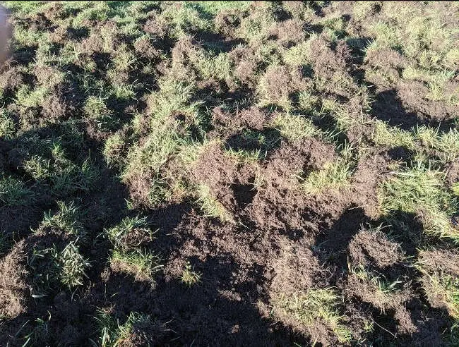
Damage at Westside Community Park in Lakeport, California, required a closure on Thursday, October 14, and Friday, October 15, 2021, for repairs. Photo courtesy of the city of Lakeport. LAKEPORT, Calif. — The city of Lakeport closed Westside Community Park on Thursday and Friday in order to address damage done by feral pigs and to work on a plan to deal with the animals.
Officials reported that over the past several weeks, large packs of feral pigs have seriously damaged the soccer fields at the park on multiple occasions.
Lakeport Public Works Department staff spent several hours on Thursday repairing the most recent damage.
City officials said the destruction of the soccer fields and other areas of Westside Community Park has resulted in significant repair costs.
In response, the city of Lakeport is working with local law enforcement and state and federal wildlife management agencies to develop and implement a plan to haze and trap the feral pigs to eliminate this ongoing problem.
The operation began on Thursday, necessitating a closure of the park.
The park also was closed on Friday evening, and slated to reopen at 6 a.m. Saturday, the city said.

 How to resolve AdBlock issue?