LAKE COUNTY, Calif. — Lake County Animal Care and Control has several cats that would be great additions to families beginning this holiday season.
Call Lake County Animal Care and Control at 707-263-0278 or visit the shelter online for information on visiting or adopting.
The following cats at the shelter have been cleared for adoption.
“Wendy” is a 6-month-old female domestic shorthair in cat room kennel No. 3, ID No. LCAC-A-4373. Photo courtesy of Lake County Animal Care and Control. ‘Wendy’
“Wendy” is a 6-month-old female domestic shorthair with a calico coat.
She is in cat room kennel No. 3, ID No. LCAC-A-4373.
This 5-month-old female domestic medium hair cat is in cat room kennel No. 36a, ID No. LCAC-A-4413. Photo courtesy of Lake County Animal Care and Control. Female domestic medium hair
This 5-month-old female domestic medium hair cat has a gray tabby coat.
She is in cat room kennel No. 36a, ID No. LCAC-A-4413.
This 5-month-old female domestic medium hair cat is in cat room kennel No. 36b, ID No. LCAC-A-4414. Photo courtesy of Lake County Animal Care and Control. Female domestic medium hair
This 5-month-old female domestic medium hair cat has a gray coat.
She is in cat room kennel No. 36b, ID No. LCAC-A-4414.
“Cris” is a 6-month-old orange tabby in cat room kennel No. 57, ID No. LCAC-A-4375. Photo courtesy of Lake County Animal Care and Control. ‘Cris’
“Cris” is a 6-month-old orange tabby with a short coat.
He is in cat room kennel No. 57, ID No. LCAC-A-4375.
This 5-month-old male domestic medium hair cat is in cat room kennel No. 77a, ID No. LCAC-A-4415. Photo courtesy of Lake County Animal Care and Control. Male domestic medium hair
This 5-month-old male domestic medium hair cat has a black coat.
He is in cat room kennel No. 77a, ID No. LCAC-A-4415.
This 5-month-old male domestic medium hair cat is in cat room kennel No. 77b, ID No. LCAC-A-4416. Photo courtesy of Lake County Animal Care and Control. Male domestic medium hair
This 5-month-old male domestic medium hair cat has a gray tabby coat.
He is in cat room kennel No. 77b, ID No. LCAC-A-4416.
“Sonny” is a 2-year-old male orange tabby in cat room kennel No. 84, ID No. LCAC-A-4372. Photo courtesy of Lake County Animal Care and Control. ‘Sonny’
“Sonny” is a 2-year-old male orange tabby with a short coat.
He is in cat room kennel No. 84, ID No. LCAC-A-4372.
Email Elizabeth Larson at This email address is being protected from spambots. You need JavaScript enabled to view it.. Follow her on Twitter, @ERLarson, or Lake County News, @LakeCoNews.
LAKE COUNTY, Calif. — Lake County Animal Care and Control has dogs waiting to go to their new homes for Christmas.
Dogs available for adoption this week include mixes of border collie, Chihuahua, German shepherd, hound, husky, Labrador retriever, pit bull, shepherd and terrier.
Dogs that are adopted from Lake County Animal Care and Control are either neutered or spayed, microchipped and, if old enough, given a rabies shot and county license before being released to their new owner. License fees do not apply to residents of the cities of Lakeport or Clearlake.
The following dogs at the Lake County Animal Care and Control shelter have been cleared for adoption.
Call Lake County Animal Care and Control at 707-263-0278 or visit the shelter online for information on visiting or adopting.
This 10-month-old female German shepherd is in kennel No. 28, ID No. LCAC-A-4297. Photo courtesy of Lake County Animal Care and Control. Female German shepherd
This 10-month-old female German shepherd has a short light-colored coat.
She is in kennel No. 28, ID No. LCAC-A-4297.
This 3-year-old male pit bull is in kennel No. 4, ID No. LCAC-A-4428. Photo courtesy of Lake County Animal Care and Control. Male pit bull
This 3-year-old male pit bull has a short brown coat.
He is in kennel No. 4, ID No. LCAC-A-4428.
“Daisy” is a 9-month-old female pit bull terrier in kennel No. 6, ID No. LCAC-A-4213. Photo courtesy of Lake County Animal Care and Control. ‘Daisy’
“Daisy” is a 9-month-old female pit bull terrier with a blue coat.
She is in kennel No. 6, ID No. LCAC-A-4213.
This 3-year-old male pit bull is in kennel No. 7, ID No. LCAC-A-4425. Photo courtesy of Lake County Animal Care and Control. Male pit bull
This 3-year-old male pit bull has a short white coat with gray markings.
He is in kennel No. 7, ID No. LCAC-A-4425.
“Tuesday” is a 2-year-old female German shepherd in kennel No. 9, ID No. LCAC-A-2855. Photo courtesy of Lake County Animal Care and Control. ‘Tuesday’
“Tuesday” is a 2-year-old female German shepherd with a short tricolor coat.
She is in kennel No. 9, ID No. LCAC-A-2855.
“Lil Man” is a 15-year-old terrier mix in kennel No. 15a, ID No. LCAC-A-4380. Photo courtesy of Lake County Animal Care and Control. ‘Lil Man’
“Lil Man” is a 15-year-old terrier mix with a short black coat.
He is in kennel No. 15a, ID No. LCAC-A-4380.
“Lil Rascal” is a 9-year-old male Chihuahua-dachshund mix in kennel No. 15b, ID No. LCAC-A-4379. Photo courtesy of Lake County Animal Care and Control. ‘Lil Rascal’
“Lil Rascal” is a 9-year-old male Chihuahua-dachshund mix with a black coat.
He is in kennel No. 15b, ID No. LCAC-A-4379.
This 3-year-old female pit bull is in kennel No. 16, ID No. LCAC-A-4378. Photo courtesy of Lake County Animal Care and Control. Female pit bull
This 3-year-old female pit bull has a short brown brindle coat.
She is in kennel No. 16, ID No. LCAC-A-4378.
This 8-month-old female hound is in kennel No. 17, ID No. LCAC-A-4386. Photo courtesy of Lake County Animal Care and Control. Female hound
This 8-month-old female hound has a fawn coat.
She is in kennel No. 17, ID No. LCAC-A-4386.
This 15-year-old female Chihuahua is in kennel No. 18, ID No. LCAC-A-4435. Photo courtesy of Lake County Animal Care and Control. Female Chihuahua
This 15-year-old female Chihuahua has a short tan coat.
She is in kennel No. 18, ID No. LCAC-A-4435.
This 7-month-old female terrier is in kennel No. 23, ID No. LCAC-A-4436. Photo courtesy of Lake County Animal Care and Control. Female terrier
This 7-month-old female terrier has a short brown coat.
She is in kennel No. 23, ID No. LCAC-A-4436.
This 4-year-old male German shepherd is in kennel No. 24, ID No. LCAC-A-4371. Photo courtesy of Lake County Animal Care and Control. Male German shepherd
This 4-year-old male German shepherd has a black and tan coat.
He is in kennel No. 24, ID No. LCAC-A-4371.
This 2-year-old female hound is in kennel No. 25, ID No. LCAC-A-4381. Photo courtesy of Lake County Animal Care and Control. Female hound
This 2-year-old female hound has a tricolor coat.
She is in kennel No. 25, ID No. LCAC-A-4381.
“Riley” is a 5-year-old female Siberian husky in kennel No. 30, ID No. LCAC-A-4382. Photo courtesy of Lake County Animal Care and Control. ‘Riley’
“Riley” is a 5-year-old female Siberian husky with a black and white coat.
She is in kennel No. 30, ID No. LCAC-A-4382.
This 3-year-old male shepherd is in kennel No. 31, ID No. LCAC-A-4312. Photo courtesy of Lake County Animal Care and Control. Male shepherd
This 3-year-old male shepherd has a short black and tan coat.
He is in kennel No. 31, ID No. LCAC-A-4312.
This 2-year-old male border collie-shepherd is in kennel No. 32, ID No. LCAC-A-4437. Photo courtesy of Lake County Animal Care and Control. Male border collie-shepherd
This 2-year-old male border collie-shepherd has a short black coat with white markings.
He is in kennel No. 32, ID No. LCAC-A-4437.
This one and a half year old female Labrador retriever is in kennel No. 33, ID No. LCAC-A-4383. Photo courtesy of Lake County Animal Care and Control. Female Labrador retriever
This one and a half year old female Labrador retriever has a short yellow coat.
She is in kennel No. 33, ID No. LCAC-A-4383.
This 3-year-old male American pit bull terrier is in kennel No. 34, ID No. LCAC-A-4402. Photo courtesy of Lake County Animal Care and Control. Male American pit bull terrier
This 3-year-old male American pit bull terrier has a short brindle coat.
He is in kennel No. 34, ID No. LCAC-A-4402.
Email Elizabeth Larson at This email address is being protected from spambots. You need JavaScript enabled to view it.. Follow her on Twitter, @ERLarson, or Lake County News, @LakeCoNews.
California Highway Patrol Commissioner Amanda Ray. Photo courtesy of the CHP. The California Highway Patrol’s first female and second Black commissioner is planning to retire.
Amanda L. Ray, commissioner of the California Highway Patrol, since her appointment in 2020, announced her retirement effective Dec. 30.
“I am humbled and proud to have served as the Commissioner of the California Highway Patrol for the last two years.” said Commissioner Ray. “I am confident the department will continue to thrive through the commitment and compassion of the incredible women and men of this great organization.”
On Nov. 17, 2020, Gov. Gavin Newsom appointed Amanda L. Ray as the 16th commissioner of the CHP; the first woman to lead the department of more than 11,000 members and the second Black commissioner.
“Commissioner Ray has been a steadfast partner in our work to protect public safety, build a CHP that is more representative of California’s communities and create a criminal justice system that better serves all Californians,” said Gov. Gavin Newsom in response to Ray’s announcement. “Working her way up the ranks to become the first woman to lead the CHP, Commissioner Ray is an inspiration to the next generation of women and men stepping up to serve our communities with compassion and understanding. I thank her for her committed leadership and service over more than 30 years at CHP and wish her all the best for the future.”
Prior to her appointment, Commissioner Ray served as the deputy commissioner and was responsible for the day-to-day operations of the CHP.
Commissioner Ray has held every rank within the CHP.
Commissioner Ray began her career in 1990 in South Los Angeles before being promoted to sergeant and lieutenant in Santa Fe Springs.
She has served as commander in the Riverside and Hayward Areas, and an assistant chief in Golden Gate Division and Inland Division, before promoting into the CHP Executive Management team.
Commissioner Ray played an integral role as the department’s first female to be assigned as the Special Response Team Tactical Commander during Super Bowl 50 held at Levi Stadium in Santa Clara.
Her vast field experience has allowed her to effectively serve as incident commander during a variety of other high-profile events including the Department’s response to COVID-19, civil unrest and wildfires.
Effective Dec. 31, Deputy Commissioner Sean Duryee will serve as the acting CHP commissioner.
“It is a great honor to have the opportunity to serve as the Acting Commissioner,” Deputy Commissioner Duryee said.
Annette Regan, University of San Francisco and Flor M. Munoz, Baylor College of Medicine
For many parents, respiratory syncytial virus – or RSV – which has been causing record numbers of hospitalizations of children during the fall of 2022, may sound like a relatively new and unheard-of threat. But in fact, RSV is a common respiratory virus that circulates every fall and winter and is a common cause of lung infections in young children.
RSV can be difficult to distinguish from other respiratory infections since the symptoms are common to other illnesses – runny nose, sneezing, congestion, coughing, fever, decreased appetite and wheezing. In most cases, RSV is mild and will improve at home. However, in certain cases, it can cause severe illness and require hospital treatment.
RSV can cause severe infections and pneumonia in anyone, including adults 65 years and older and those with chronic lung or heart conditions or weakened immune systems. But it is most commonly severe in young children.
Unfortunately, although RSV is a very common respiratory threat, treatments for it are relatively limited, and as yet, there is no vaccine against it. However, 2023 is likely to be a pivotal year for RSV prevention strategies and treatments.
How to keep your child safe from RSV.
Treating children for RSV
Current guidelines recommend supportive care, which essentially means managing symptoms and trying to make children as comfortable as possible until they are well again. This includes offering plenty of fluids to avoid dehydration and using over-the-counter medications such as acetaminophen to reduce any fever.
Antibiotics are not useful for treating RSV since they only target bacterial infections and RSV is caused by a virus. But sometimes, children with RSV can also develop secondary bacterial infections in the lungs, in which case antibiotics may be prescribed.
There are a range of medications that have been tried on children with RSV, but for the most part, they’ve shown little benefit. For example, many studies have trialed the use of inhalers and corticosteroid medications, but results have shown that neither significantly reduces the severity of RSV. These medications are therefore not routinely recommended for children to treat severe RSV.
The only drug approved by the Food and Drug Administration to treat RSV is ribavirin, an antiviral medication. It is aerosolized using a special nebulizing machine and needs to be given in the hospital for periods of eight to 24 hours over three to five days. The drug works by trying to stop the virus from replicating in the respiratory tract.
The trials evaluating ribavirin have been small, which means we can’t really be certain of its benefits. Because ribavirin is very expensive and its benefits uncertain, the American Academy of Pediatrics no longer routinely recommends it for treatment of RSV, except for specific cases in very high-risk patients.
Fortunately, most babies and young children with RSV do not require treatment and recover well with supportive care. But some can become very ill and need substantial care from their doctors, parents and family members.
While RSV can result in serious disease for any child, children in high-risk groups face more serious threats from RSV. These include babies less than 6 months old, premature infants, children under 2 years old with chronic lung disease or congenital heart disease, children with suppressed immune systems and children with neuromuscular disorders.
Children may require hospital care if they are having difficulty breathing, have a fever that does not go away after two days, or have lost energy and no longer eat, drink or urinate. This is primarily so they can be monitored and receive intravenous fluids to keep hydrated and ventilators to help with breathing. Approximately 1%-2% of babies less than 6 months old with RSV will be hospitalized.
It’s important to know that children infected with RSV might take a turn for the worse before they get better. This is because, in addition to severe nasal congestion that interferes with their feeding, the inflammation in their airways and lungs may prevent them from breathing properly and keeping a normal oxygen level in their blood. These are the children who end up in emergency rooms and hospitals during the respiratory virus season.
The future of RSV treatment is prevention
Since effective treatments for severe RSV in children are so limited, the primary goal is to prevent the disease from happening in the first place.
One prevention strategy is to treat infants and children who are at high risk of severe disease before they get sick. This includes very preterm infants and those with heart and lung conditions.
A monoclonal antibody called palivizumab can be given as a series of shots and is usually reserved for use during the RSV season. But since RSV has been so variable throughout the COVID-19 pandemic, and in response to the early increase in RSV hospitalizations in children this year, the American Academy of Pediatrics recently updated its guidelines to allow administration of palivizumab whenever RSV is in high circulation.
But to really get ahead of the RSV threat, we believe the health care field needs prevention strategies that can protect all children from the disease from birth.
RSV, flu and COVID-19 cases continue to fill U.S. hospitals.
The promise of vaccines
Despite more than five decades of research, there is still no RSV vaccine available for children. This is because developing a vaccine that really works has been tricky. RSV vaccines target the F protein, the part of the virus that it uses to infect cells, and this protein has different forms before and after infecting the cells. RSV vaccines are in development for three groups, including infants 4 to 6 months old, adults 65 years and older, and pregnant people.
RSV vaccination during pregnancy produces RSV-specific antibodies in the mother that can then cross the placenta to protect the baby. These maternal antibodies generally offer protection for the first six months of a baby’s life. A recent clinical trial showed that RSV vaccination during pregnancy reduced the risk of RSV hospitalization by 82% in infants less than 3 months old. These are very promising results.
Another viable option for the prevention of RSV for all young babies is the use of long-acting RSV-specific antibodies that can be given either at birth or prior to the RSV season. These could provide immunity to infants for several months while RSV is in circulation. A recent clinical trial showed that one of these products, nirsevimab, reduced the risk of RSV hospitalization by 62% in children less than 1 year old.
Looking ahead
One positive outcome of fall 2022’s record RSV season is that it has raised public awareness of RSV and created renewed urgency around the need to find more effective preventive strategies and RSV treatments.
The success of these tools and strategies will largely depend on their acceptance and utilization by well-informed parents and providers.
Usually, parents become aware of RSV only after having experienced it in their own family. But pediatric providers know all too well from caring for their patients what RSV can do to young bodies. When parents and providers share these stories, it becomes a powerful testament to the need for preventive strategies to fight RSV.
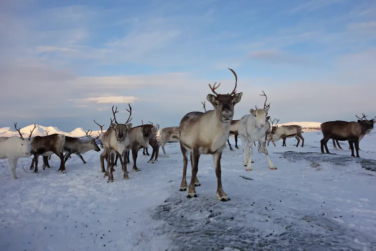
Rainier winters make life more difficult for Arctic wildlife and the humans who rely on them. Scott Wallace/Getty Image
In the Arctic, the freedom to travel, hunt and make day-to-day decisions is profoundly tied to cold and frozen conditions for much of the year. These conditions are rapidly changing as the Arctic warms.
The Arctic is now seeing more rainfall when historically it would be snowing. Sea ice that once protected coastlines from erosion during fall storms is forming later. And thinner river and lake ice is making travel by snowmobile increasingly life-threatening.
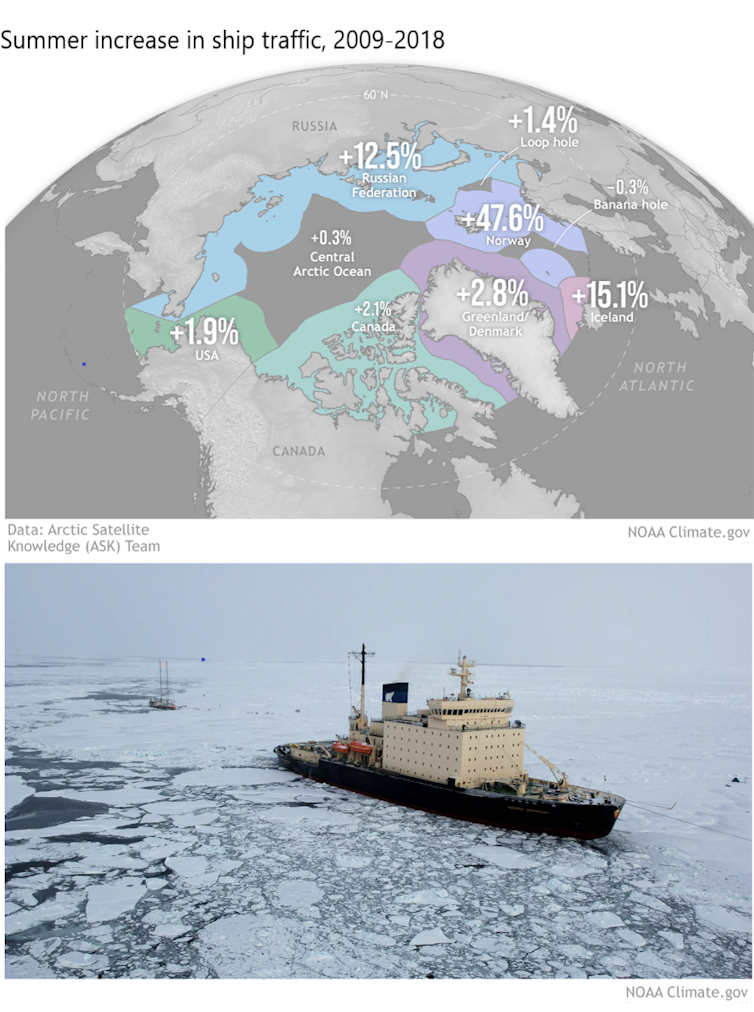
Ship traffic in the Arctic is also increasing, bringing new risks to fragile ecosystems, and the Greenland ice sheet is continuing to send freshwater and ice into the ocean, raising global sea level
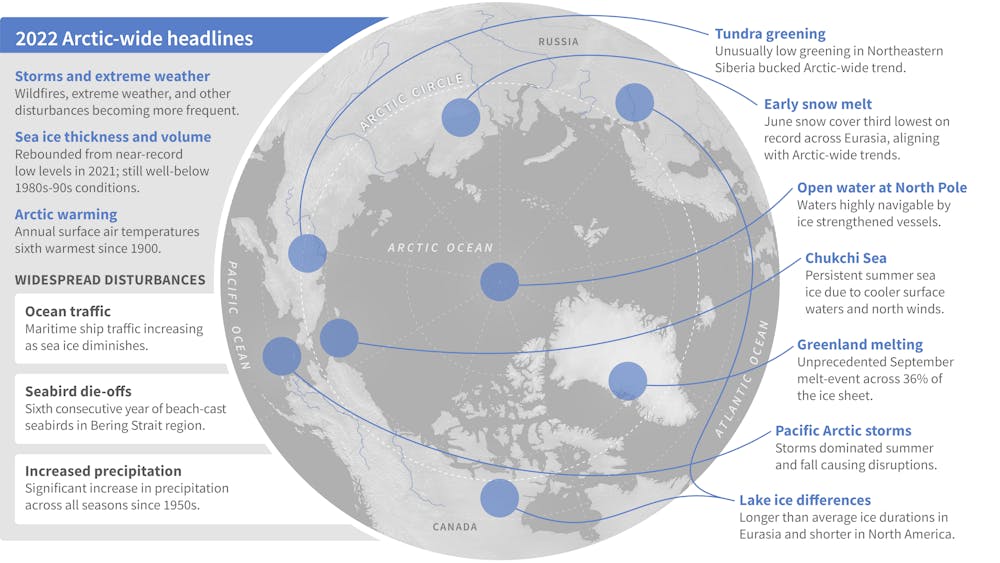
In the annual Arctic Report Card, released Dec. 13, 2022, we brought together 144 other Arctic scientists from 11 countries to examine the current state of the Arctic system.
Some of the Arctic headlines of 2022 discussed in the Arctic Report Card.NOAA Climate.gov
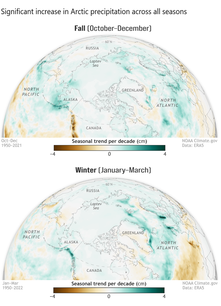
Much of this new precipitation is now falling as rain, sometimes during winter and traditionally frozen times of the year. This disrupts daily life for humans, wildlife and plants.
Roads become dangerously icy more often, and communities face greater risk of river flooding events. For Indigenous reindeer herding communities, winter rain can create an impenetrable ice layer that prevents their reindeer from accessing vegetation beneath the snow.
Arctic-wide, this shift toward wetter conditions can disrupt the lives of animals and plants that have evolved for dry and cold conditions, potentially altering Arctic peoples’ local foods.
When Fairbanks, Alaska, got 1.4 inches of freezing rain in December 2021, the moisture created an ice layer that persisted for months, bringing down trees and disrupting travel, infrastructure and the ability of some Arctic animals to forage for food. The resulting ice layer was largely responsible for the deaths of a third of a bison herd in interior Alaska.
There are multiple reasons for this increase in Arctic precipitation.
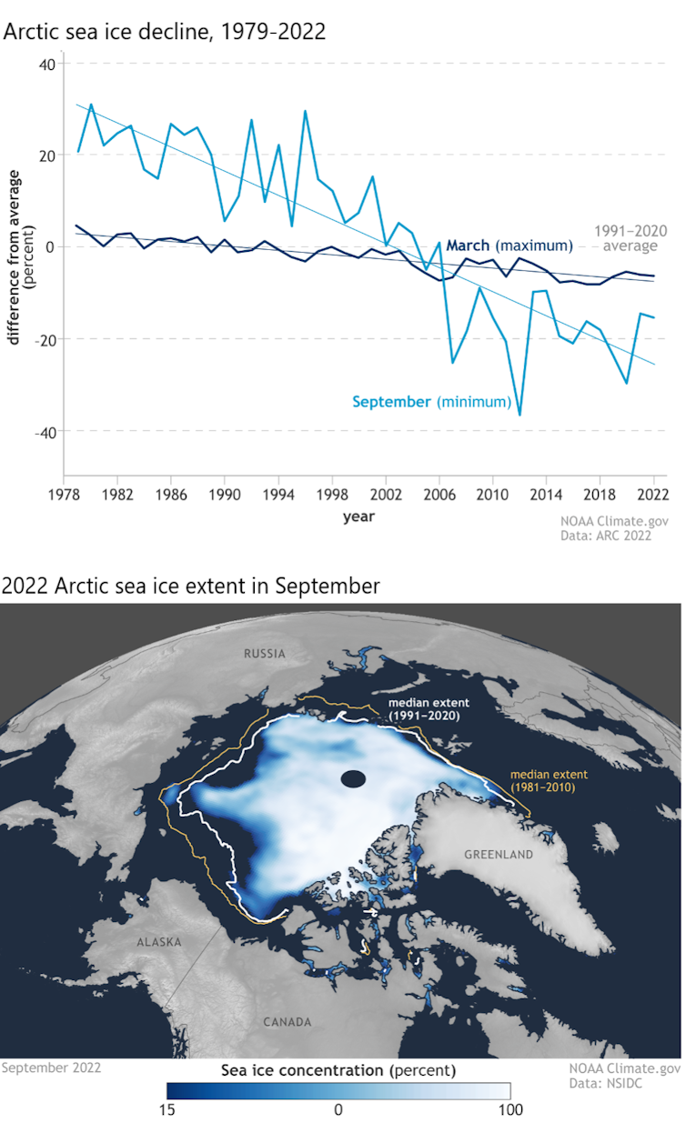
As sea ice rapidly declines, more open water is exposed, which feeds increased moisture into the atmosphere. The entire Arctic region has seen a more than 40% loss in summer sea ice extent over the 44-year satellite record.
Under the ground, the wetter, rainier Arctic is accelerating the thaw of permafrost, upon which most Arctic communities and infrastructure are built. The result is crumbling buildings, sagging and cracked roads, the emergence of sinkholes and the collapse of community coastlines along rivers and ocean.
Wetter weather also disrupts the building of a reliable winter snowpack and safe, reliable river ice, and often challenges Indigenous communities’ efforts to harvest and secure their food.
When Typhoon Merbok hit in September 2022, fueled by unusually warm Pacific water, its hurricane-force winds, 50-foot waves and far-reaching storm surge damaged homes and infrastructure over 1,000 miles of Bering Sea coastline, and disrupted hunting and harvesting at a crucial time.
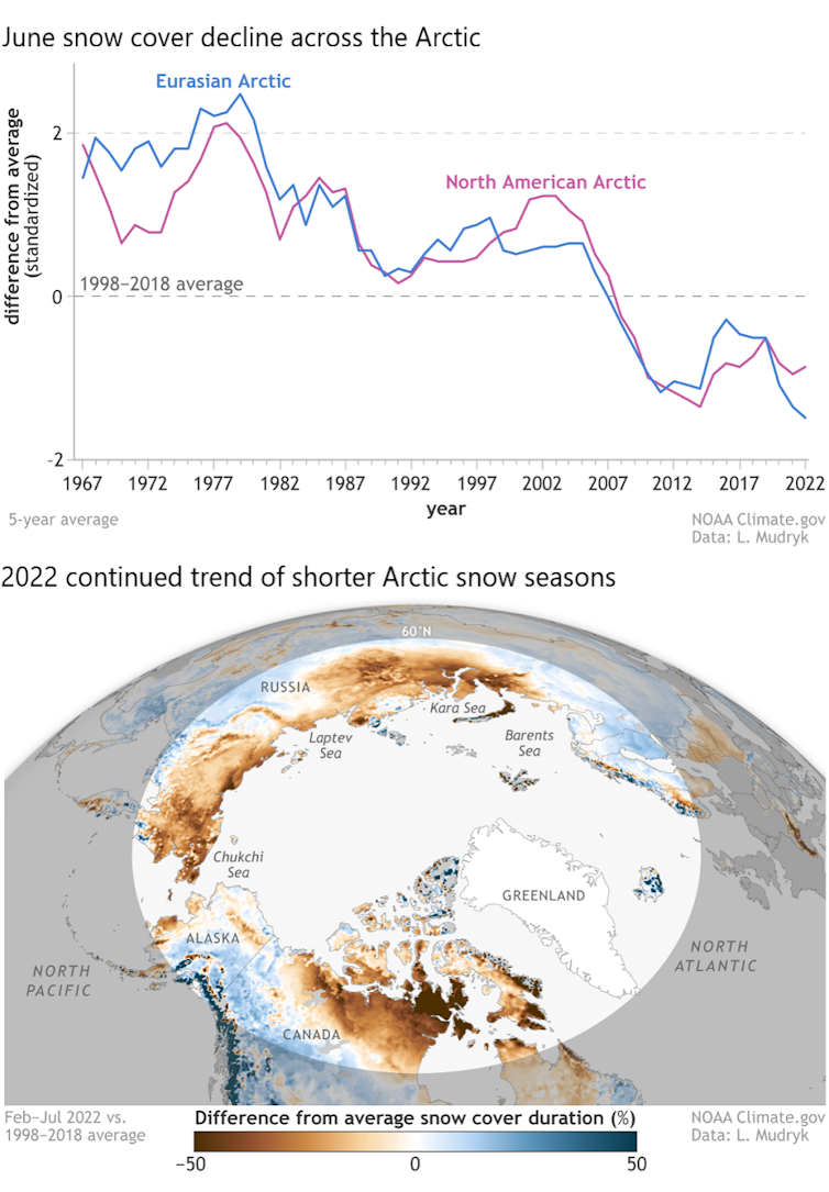
Snow plays critical roles in the Arctic, and the snow season is shrinking.
Snow helps to keep the Arctic cool by reflecting incoming solar radiation back to space, rather than allowing it to be absorbed by the darker snow-free ground. Its presence helps lake ice last longer into spring and helps the land to retain moisture longer into summer, preventing overly dry conditions that are ripe for devastating wildfires.
Snow is also a travel platform for hunters and a habitat for many animals that rely on it for nesting and protection from predators.
A shrinking snow season is disrupting these critical functions. For example, the June snow cover extent across the Arctic is declining at a rate of nearly 20% per decade, marking a dramatic shift in how the snow season is defined and experienced across the North.
Even in the depth of winter, warmer temperatures are breaking through. The far northern Alaska town of Utqiaġvik hit 40 degrees Fahrenheit (4.4 C) – 8 F above freezing – on Dec. 5, 2022, even though the sun does not breach the horizon from mid-November through mid-January.
Fatal falls through thin sea, lake and river ice are on the rise across Alaska, resulting in immediate tragedies as well as adding to the cumulative human cost of climate change that Arctic Indigenous peoples are now experiencing on a generational scale.
Greenland ice melt means global problems
The impacts of Arctic warming are not limited to the Arctic. In 2022, the Greenland ice sheet lost ice for the 25th consecutive year. This adds to rising seas, which escalates the danger coastal communities around the world must plan for to mitigate flooding and storm surge.
International teams of scientists are dedicated to assessing the scale to which the Greenland ice sheet’s ice formation and ice loss are out of balance. They are also increasingly learning about the transformative role that warming ocean waters play.
We are living in a new geological age — the Anthropocene — in which human activity is the dominant influence on our climate and environments.
In the warming Arctic, this requires decision-makers to better anticipate the interplay between a changing climate and human activity. For example, satellite-based ship data since 2009 clearly show that maritime ship traffic has increased within all Arctic high seas and national exclusive economic zones as the region has warmed.
For these ecologically sensitive waters, this added ship traffic raises urgent concerns ranging from the future of Arctic trade routes to the introduction of even more human-caused stresses on Arctic peoples, ecosystems and the climate. These concerns are especially pronounced given uncertainties regarding the current geopolitical tensions between Russia and the other Arctic states over its war in Ukraine.
Rapid Arctic warming requires new forms of partnership and information sharing, including between scientists and Indigenous knowledge-holders. Cooperation and building resilience can help to reduce some risks, but global action to rein in greenhouse gas pollution is essential for the entire planet.
CLEARLAKE, Calif. — Clearlake Animal Control shelter is full of pets wanting to go home with new families for the holidays.
The City of Clearlake Animal Association also is seeking fosters for the animals waiting to be adopted.
Call the Clearlake Animal Control shelter at 707-273-9440, or email This email address is being protected from spambots. You need JavaScript enabled to view it. to inquire about adoptions and schedule a visit to the shelter.
Visit Clearlake Animal Control on Facebook or on the city’s website.
The following dogs are available for adoption.
“Aoki.” Photo courtesy of Clearlake Animal Control. ‘Aoki’
“Aoki” is a male Siberian husky mix with a white coat.
He has been neutered.
He is dog No. 50905477.
“Athena.” Photo courtesy of Clearlake Animal Control. ‘Athena’
“Athena” is a female American pit bull mix terrier with a short brindle coat.
She has been spayed.
She is dog No. 49934476.
“Atlas.” Photo courtesy of Clearlake Animal Control. ‘Atlas’
“Atlas” is a male German shepherd with a black and tan coat.
He has been neutered.
He is dog No. 51331471.
“Babs.” Photo courtesy of Clearlake Animal Control. ‘Babs’
“Babs” is a female Labrador retriever mix with a short black coat.
She has been spayed.
She is dog No. 49505856.
“Bruce.” Photo courtesy of Clearlake Animal Control. ‘Bruce’
“Bruce” is a 2-year-old American pit bull mix with a short gray coat with white markings.
He has been neutered.
He is dog No. 50684304.
“Buster.” Photo courtesy of Clearlake Animal Control. ‘Buster’
“Buster” is a male pit bull mix with a short tan coat.
He has been neutered.
He is dog No. 50762164.
“Domino.” Photo courtesy of Clearlake Animal Control. ‘Domino’
“Domino” is a male terrier mix with a short white coat.
He has been neutered.
He is dog No. 50815541.
“Eros.” Photo courtesy of Clearlake Animal Control. ‘Eros’
“Eros” is a male Rottweiler mix with a short black and tan coat.
He has been neutered.
He is dog No. 50754504.
“Foxie.” Photo courtesy of Clearlake Animal Control. ‘Foxie’
“Foxie” is a female German shepherd with a red, black and white coat.
She has been spayed.
She is dog No. 49702845.
“Goliath.” Photo courtesy of Clearlake Animal Control. ‘Goliath’
“Goliath” is a male Rottweiler mix with a short black and tan coat.
He is dog No. 50754509.
“Hakuna.” Photo courtesy of Clearlake Animal Control. ‘Hakuna’
“Hakuna” is a male shepherd mix with a tan coat.
He has been neutered.
He is dog No. 50176912.
“Herman.” Photo courtesy of Clearlake Animal Control. ‘Herman’
“Herman” is a 7-year-old male American pit bull terrier mix with a brown coat.
He has been neutered.
He is dog No. 51236411.
“Hondo.” Photo courtesy of Clearlake Animal Control. ‘Hondo’
“Hondo” is a male Alaskan husky mix with a buff coat.
He has been neutered.
He’s dog No. 50227693.
“Jack.” Photo courtesy of Clearlake Animal Control. ‘Jack’
“Jack” is a 9-month-old male terrier mix with a short black and brindle coat.
He has been neutered.
He is dog No. 50992658.
“Kubota.” Photo courtesy of Clearlake Animal Control. ‘Kubota’
“Kubota” is a 4-year-old male German shepherd with a short brown coat.
He has been neutered.
He is dog No. 50184421.
“Little Boy.” Photo courtesy of Clearlake Animal Control. ‘Little Boy’
“Little Boy” is a male American pit bull terrier mix with a short tan coat.
He has been neutered.
He is dog No. 50075256.
“Luciano.” Photo courtesy of Clearlake Animal Control. ‘Luciano’
“Luciano” is a male Siberian husky mix with a short black and white coat.
He has been neutered.
He is dog No. 50596272.
“Mamba.” Photo courtesy of Clearlake Animal Control. ‘Mamba’
“Mamba” is a male Siberian husky mix with a gray and cream-colored coat.
He has been neutered.
He is dog No. 49520569.
“Matata.” Photo courtesy of Clearlake Animal Control. ‘Matata’
“Matata” is male shepherd mix with a tan coat.
He has been neutered.
He is dog No. 50176912.
“Maverick.” Photo courtesy of Clearlake Animal Control. ‘Maverick’
“Maverick” is a male pit bull-border collie mix with a short black and white coat.
He has been neutered.
He is dog No. 51027806.
“Maya.” Photo courtesy of Clearlake Animal Control. ‘Maya’
“Maya” is a female German shepherd with a black and tan coat.
She has been spayed.
She is dog No. 50428151.
“Mikey.” Photo courtesy of Clearlake Animal Control. ‘Mikey’
“Mikey” is a male German shepherd mix with a short brown and tan coat.
He has been neutered.
He is dog No. 51012855.
“Molly.” Photo courtesy of Clearlake Animal Control. ‘Molly’
“Molly” is a female Samoyed mix with a long white coat.
She has been spayed.
She is dog No. 50933031.
“Noah.” Photo courtesy of Clearlake Animal Control. ‘Noah’
“Noah” is a male pit bull terrier mix with a short white coat.
He has been neutered.
He is dog No. 51286102.
“Paige.” Photo courtesy of Clearlake Animal Control. ‘Paige’
“Paige” is a female American pit bull mix with a short brown coat.
She has been spayed.
She is dog No. 51194668.
“Poppa.” Photo courtesy of Clearlake Animal Control. ‘Poppa’
“Poppa” is a 3-year-old male American pit bull terrier mix with a short red and white coat.
He has been neutered.
He is dog No. 50773597.
“Rascal.” Photo courtesy of Clearlake Animal Control. ‘Rascal’
“Rascal” is a male shepherd mix with a black and brown coat.
He has been neutered.
He is dog No. 50806384.
“Reese.” Photo courtesy of Clearlake Animal Control. ‘Reese’
“Reese” is a female German shepherd with a black and an coat.
She has been spayed.
She is dog No. 50884542.
“Snowball.” Photo courtesy of Clearlake Animal Control. ‘Snowball’
“Snowball is a 1 and a half year old male American Staffordshire terrier mix with a short white coat.
He has been neutered.
He is dog No. 49159168.
“Terry.” Photo courtesy of Clearlake Animal Control. ‘Terry’
“Terry” is a handsome male shepherd mix with a short brindle coat.
He gets along with other dogs, including small ones, and enjoys toys. He also likes water, playing fetch and keep away.
Staff said he is now getting some training to help him build confidence.
He is dog No. 48443693.
“Trike.” Photo courtesy of Clearlake Animal Control. ‘Trike’
“Trike” is a male border collie-Australian shepherd mix with a black and white coat and blue eyes.
He has been neutered.
He is dog No. 51029972.
“Willie.” Photo courtesy of Clearlake Animal Control. ‘Willie’
“Willie” is a male German shepherd mix with a black and tan coat.
He has been neutered.
He is dog No. 50596003.
“Zeus.” Photo courtesy of Clearlake Animal Control. ‘Zeus’
“Zeus” is a male Samoyed mix with a long white coat.
He has been neutered.
He is dog No. 50933068.
Email Elizabeth Larson at This email address is being protected from spambots. You need JavaScript enabled to view it.. Follow her on Twitter, @ERLarson, or Lake County News, @LakeCoNews.
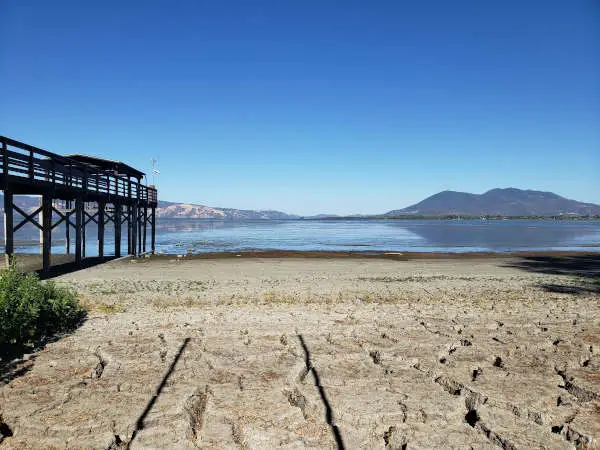
New research conducted through a partnership with the Lake County Water Resources staff, Michigan State University and the University of Vermont looks at the Clear Lake, wildfires and climate change. Photo courtesy of Lake County Water Resources.
Angela DePalma-Dow, Lake County Water Resources Department Invasive Species Program coordinator and “Lady of the Lake” columnist, served as lead author of ecosphere-published work
LAKE COUNTY, Calif. — Lake County Water Resources staff and researchers from Michigan State University and University of Vermont partnered to investigate current water quality trends in Clear Lake, and their relationship to wildfires and climate change.
The research team evaluated water quality monitoring data from the last three large wildfire years in the Clear Lake Basin, including 2018 (Mendocino Complex), in comparison to long-term water quality nutrient data.
“Right after the Mendocino Complex, our department received many calls from the public concerned about the fire’s impact on Clear Lake water quality,” said Angela De Palma-Dow, County Invasive Species Program coordinator and lead author and primary investigator for the research effort.
“And while there is a plethora of wildfire water quality research out there, none includes a lake as large and productive (i.e., biomass- and species-dense, nutrient-rich and eutrophic) as Clear Lake. This was a great opportunity for our team to closely review the data, and inform public discussion and planning efforts,” said De Palma-Dow, who also writes the “Lady of the Lake” column.
The research effort aimed to identify the influence of wildfires, water and air temperature, and precipitation on water quality in Clear Lake. Climate change data was collected from a variety of public, open sources. Water quality data was sourced from a long-term collaborative water monitoring program undertaken by the California Department of Water Resources, County Water Resources staff and local Tribal governments.
For about 60 years, members of this collaborative have collected monthly water quality data from Clear Lake’s three arms. Clear Lake has become much more nutrient-rich and productive over time, a process known as “eutrophication.” This trend is pronounced after the mid 1980’s and in times of drought.
Eutrophication is typically fueled by increased nutrient inputs, primarily phosphorus. Nutrients lead to growth of both algae (phytoplankton) and cyanobacteria, turning the water green.
When algae and cyanobacteria die and decompose, this can result in foul odors and release of toxins, disrupting recreation in affected areas of the lake. Thick green mats on the surface of the lake can be observable from shorelines.
These conditions increase in frequency and severity when water temperatures are very warm and especially when lake levels are low (e.g., drought).
Researchers analyzed what variables were most associated with increased phosphorus over time, especially during the heavy bloom season, from July through October.
Watershed areas burned by wildfire, seasonal air and water temperatures, and seasonal precipitation were assessed. Phosphorus increases in Clear Lake were primarily driven by lack of rain and warmer air and water temperatures.
“We found higher phosphorus concentrations, over the long term, were associated with hot and dry weather, not rain, alone, or rain following wildfires,” co-author Dr. Ian McCullough of Michigan State University added. Climate change may be a greater threat to Clear Lake water quality than wildfires.
Higher water temperatures, at the top and bottom of the water column, are also associated with observed increases in phosphorus. These findings are most pronounced in the data after 1985.
“What could be happening here is release of phosphorus from lake sediment,” said Dr. Jennie Brentrup, study co-author and aquatic scientist at the Cary Institute of Ecosystem Studies. “Part of the issue is warmer water holds less oxygen, and decomposing algae and cyanobacteria also consume oxygen at the lake bottom. As the lake heats up and less oxygen is available, more phosphorus can be released from the sediment and mix into surface waters, further fueling the cycle of eutrophication.”
Sedimentary phosphorus release must be considered in future management of Clear Lake. The Blue Ribbon Committee for the Rehabilitation of Clear Lake, or BRC, just approved $2.25 million for a hypolimnetic oxygenation pilot study to be conducted in the Oaks arm of the Lake.
This project will inject oxygen directly into the bottom of the lake to “trap” phosphorus in the sediments, preventing the food source for cyanobacteria; its aim is to stop severe blooms from occurring, in the first place.
More information on this project and the BRC is available through the California Natural Resources Agency’s website.
Clear Lake is a critical asset, supporting Lake County fisheries, water-based tourism and local economic activity.
Its waters are used for irrigation, recreation, and tribal cultural practices, and also drinking water for 40,000 people, or nearly 60% of the county’s population, the majority of whom are low income and/or members of local tribes — Big Valley Band of Pomo Indians, Habematolel Pomo of Upper Lake, Robinson Rancheria Pomo Indians of California, Scotts Valley Band of Pomo Indians and Elem Indian Colony.
County Water Resources staff value this research.
“As stewards of the Lake, we rely on long-term monthly monitoring data,” said Scott De Leon, Lake County’s Water Resources director. “Wildfires and droughts are expected to grow more frequent, and Angela and the research team’s findings valuably interpret the role multiple climate-informed factors play in the water quality outcomes we are seeing. Our team continually seeks to augment our understanding and plan future efforts in accordance with the best available data.”
If you have any questions or need more information, please contact the Water Resources Department at This email address is being protected from spambots. You need JavaScript enabled to view it., or by phone, at 707-263-2344.
Also visit the Water Resources Department’s website or the “Lake County Water Resources Department” Facebook page, @lakecountywater.
Please direct questions on, “Turning up the Heat: Long-term water quality responses to wildfires and climate change in a hypereutrophic lake,” specifically, to This email address is being protected from spambots. You need JavaScript enabled to view it..
This image is constructed from several images taken on Nov. 30, 2022 by astronomers at Magdalena Ridge Observatory in New Mexico, USA. It holds Didymos still in the frame, and thus the background stars are seen as linear trails of dots. Average images like this can provide additional details to astronomers studying faint structures in the ejecta tail. This image is roughly 32,000 kilometers across the field of view at the distance of Didymos. Credit: Magdalena Ridge Observatory/NM Tech. Since NASA’s Double Asteroid Redirection Test, or DART, spacecraft intentionally slammed into the asteroid moonlet Dimorphos on Sept. 26 — altering its orbit by 33 minutes — the investigation team has been digging into the implications of how this planetary defense technique could be used in the future, if such a need should ever arise.
This has included further analysis of the “ejecta” — the many tons of asteroidal rock displaced and launched into space by the impact — the recoil from which substantially enhanced DART’s push against Dimorphos.
Continued observations of that evolving ejecta have given the investigation team better understanding of what the DART spacecraft achieved at the impact site. DART team members provided a preliminary interpretation of their findings during the American Geophysical Union’s Fall Meeting on Thursday, Dec. 15, in Chicago.
“What we can learn from the DART mission is all part of a NASA’s overarching work to understand asteroids and other small bodies in our Solar System,” said Tom Statler, the program scientist for DART at NASA headquarters in Washington, and one of the presenters at the briefing. “Impacting the asteroid was just the start. Now we use the observations to study what these bodies are made of and how they were formed — as well as how to defend our planet should there ever be an asteroid headed our way.”
Central to this effort are detailed, post-impact science and engineering analyses of data from the world’s first planetary defense technology demonstration. In the weeks after impact, scientists turned their focus toward measuring the momentum transfer from DART’s roughly 14,000 mile per hour (22,530 kilometer per hour) collision with its target asteroid.
Scientists estimate DART’s impact displaced over two million pounds (one million kilograms) of the dusty rock into space — enough to fill six or seven rail cars. The team is using that data — as well as new information on the composition of the asteroid moonlet and the characteristics of the ejecta, gained from telescope observations and images from DART’s ride-along Light Italian CubeSat for Imaging of Asteroids (LICIACube) contributed by the Italian Space Agency (ASI) — to learn just how much DART’s initial hit moved the asteroid, and how much came from the recoil.
“We know the initial experiment worked. Now we can start to apply this knowledge,” said Andy Rivkin, DART investigation team colead at the Johns Hopkins Applied Physics Lab (APL). “Studying the ejecta made in the kinetic impact — all of it derived from Dimorphos — is a key way of gaining further insights into the nature of its surface.”
Observations before and after impact, reveal that Dimorphos and its larger parent asteroid, Didymos, have similar makeup and are composed of the same material — material that has been linked to ordinary chondrites, similar to the most common type of meteorite to impact the Earth. These measurements also took advantage of the ejecta from Dimorphos, which dominated the reflected light from the system in the days after impact. Even now, telescope images of the Didymos system show how solar radiation pressure has stretched the ejecta stream into a comet-like tail tens of thousands of miles in length.
Putting those pieces together, and assuming that Didymos and Dimorphos have the same densities, the team calculates that the momentum transferred when DART hit Dimorphos was roughly 3.6 times greater than if the asteroid had simply absorbed the spacecraft and produced no ejecta at all — indicating the ejecta contributed to moving the asteroid more than the spacecraft did.
Accurately predicting momentum transfer is central to planning a future kinetic impact mission if one is ever needed, including determining the size of the impactor spacecraft and estimating the amount of lead-time necessary to ensure that a small deflection would move a potentially dangerous asteroid off its path.
“Momentum transfer is one of the most important things we can measure, because it is information we would need to develop an impactor mission to divert a threatening asteroid,” said Andy Cheng, DART investigation team lead from Johns Hopkins APL. “Understanding how a spacecraft impact will change an asteroid’s momentum is key to designing a mitigation strategy for a planetary defense scenario.”
Neither Dimorphos nor Didymos poses any hazard to Earth before or after DART’s controlled collision with Dimorphos.
Johns Hopkins APL built and operated the DART spacecraft and manages the DART mission for NASA's Planetary Defense Coordination Office as a project of the agency's Planetary Missions Program Office.
The last complete image of asteroid moonlet Dimorphos, taken by the DRACO imager on NASA’s DART mission from ~7 miles (12 kilometers) from the asteroid and 2 seconds before impact. The image shows a patch of the asteroid that is 100 feet (31 meters) across. Ecliptic north is toward the bottom of the image. This image is shown as it appears on the DRACO detector and is mirror flipped across the x-axis from reality. Credits: NASA/Johns Hopkins APL.
LAKE COUNTY, Calif. — Recent rains and cooler temperatures across the region have lowered the threat of wildfires.
As a result, this week Cal Fire Sonoma-Lake-Napa Unit Chief Mike Marcucci announced the lifting of the requirement on Cal Fire permits needed for burning in the State Responsibility Areas, or SRA, of Colusa, Napa, Solano, Sonoma and Yolo counties.
The lifting of that requirement went into effect at 8 a.m. Monday, Dec. 12 at 8 a.m.
For information on burn permits for Lake County, please visit the South Lake County Fire Protection District website at https://www.southlakecountyfire.org./home/permits/.
Marcucci reminded residents that while we are enjoying the rain and cooler temperatures, we are living in a year-round fire season.
“Please take the time to ensure your property and homes are ready for the next time that fire strikes,” Marcucci said. “It is also a great time to ensure that your flues and chimneys are clean as well.”
Marcucci also reminded residents that safe residential pile burning of forest residue by landowners is a crucial tool in reducing fire hazards.
State, federal and local land management and fire agencies also utilize this same window of opportunity to conduct prescribed burns aimed at improving forest health and reducing fuels on private and public lands.
Extinction is part of life on Earth. Through much of our planet’s history, species have been forming, evolving and eventually disappearing. Today, however, human activities have dramatically sped up the process. The Earth is losing animals, birds, reptiles and other living things so fast that some scientists believe the planet is entering the sixth mass extinction in its history.
On Dec. 7, 2022, the United Nations will convene governments from around the world in Montreal for a 10-day conference that aims to establish new goals for protecting Earth’s ecosystems and their biodiversity – the variety of life at all levels, from genes to ecosystems. There’s broad agreement that there is a biodiversity crisis, but there are many different views about why protecting it is important.
Some people, cultures and nations believe biodiversity is worth conserving because ecosystems provide many services that support human prosperity, health and well-being. Others assert that all living things have a right to exist, regardless of their usefulness to humans. Today, there’s also growing understanding that nature enriches our lives by providing opportunities for us to connect with each other and the places we care about.
As a conservation biologist, I’ve been part of the effort to value biodiversity for years. Here’s how thinking in this field has evolved, and why I’ve come to believe that there are many equally valid reasons for protecting nature.
Biodiversity describes the amount of genetic diversity within species and the range of species that make up ecosystems.
In a 1985 essay, Michael Soulé, one of the field’s founders, described what he saw as the core principles of conservation biology. Soulé argued that biological diversity is inherently good and should be conserved because it has intrinsic value. He also proposed that conservation biologists should act to save biodiversity even if sound science isn’t available to inform decisions.
Soulé’s essay spurred many researchers to push for a more science-driven approach to conservation. They sought to directly quantify the value of ecosystems and the roles species played in them. Some scholars focused on calculating the value of ecosystems to humans.
They reached a preliminary conclusion that the total economic value of the world’s ecosystems was worth an average US$33 trillion per year in 1997 dollars. At the time, this was nearly twice the global value of the entire world’s financial markets.
This estimate included services such as predators controlling pests that would otherwise ruin crops; pollinators helping to produce fruits and vegetables; wetlands, mangroves and other natural systems buffering coasts against storms and flooding; oceans providing fish for food; and forests providing lumber and other building materials.
Researchers have refined their estimates of what these benefits are worth, but their central conclusion remains the same: Nature has shockingly high economic value that existing financial markets don’t account for.
Many experts say that conventional economic thinking fails to recognize the cost of damaging nature – but calculating values for biodiversity could change that.
This research found that spending time in nature tended to reduce blood pressure, lower hormones related to stress and anxiety, decrease the probability of depression and improve cognitive function and certain immune functions. People exposed to nature fared better than others who took part in similar activities in nonnatural settings, such as walking through a city.
Losing species weakens ecosystems
A third line of research asked a different question: When ecosystems lose species, can they still function and provide services? This work was driven mainly by experiments where researchers directly manipulated the diversity of different types of organisms in settings ranging from laboratory cultures to greenhouses, plots in fields, forests and coastal areas.
By 2010, scientists had published more than 600 experiments, manipulating over 500 groups of organisms in freshwater, marine and land ecosystems. In a 2012 review of these experiments, colleagues and I found unequivocal evidence that when ecosystems lose biodiversity, they become less efficient, less productive and less stable. And they are less able to deliver many of the services that underlie human well-being.
For example, we found strong evidence that loss of genetic diversity reduced crop yields, and loss of tree diversity reduced the amount of wood that forests produced. We also found evidence that oceans with fewer fish species produced less-reliable catches, and that ecosystems with lower plant diversity were more prone to invasive pests and diseases.
A standard lawn, at left, is a monoculture that supports very little life. A more mixed, diverse version, at right, offers food for pollinators.woodleywonderworks/Flickr, CC BY
We also showed that it was possible to develop robust mathematical models that could predict reasonably well how biodiversity loss would affect certain types of valuable services from ecosystems.
Many motives for protecting nature
For years, I believed that this work had established the value of ecosystems and quantified how biodiversity provided ecosystem services. But I’ve come to realize that other arguments for protecting nature are just as valid, and often more convincing for many people.
I have worked with many people who donate money or land to support conservation. But I’ve never heard anyone say they were doing it because of the economic value of biodiversity or its role in sustaining ecosystem services.
Instead, they’ve shared stories about how they grew up fishing with their father, held family gatherings at a cabin or canoed with someone who was important to them. They wanted to pass on those experiences to their children and grandchildren to preserve familial relationships. Researchers increasingly recognize that such relational values – connections to communities and to specific places – are one of the most common reasons why people choose to conserve nature.
I also know many people who hold deep religious beliefs and are rarely swayed by scientific arguments for conservation. But when Pope Francis published his 2015 encyclical Laudato si’: On Care for Our Common Home and said God’s followers had a moral responsibility to care for his creation, my religious relatives, friends and colleagues suddenly wanted to know about biodiversity loss and what they might do about it.
Surveys show that 85% of the world’s population identifies with a major religion. Leaders of every major religion have published declarations similar to Pope Francis’ encyclical, calling on their followers to be better stewards of Earth. Undoubtedly, a large portion of humanity assigns moral value to nature.
Research clearly shows that nature provides humanity with enormous value. But some people simply believe that other species have a right to exist, or that their religion tells them to be good stewards of Earth. As I see it, embracing these diverse perspectives is the best way to get global buy-in for conserving Earth’s ecosystems and living creatures for the good of all.
Cal Fire’s Office of the State Fire Marshal is beginning a public comment period for the regulatory adoption process to update the existing map that captures Fire Hazard Severity Zones, or FHSZ, which is a comprehensive map that ranks California’s State Responsibility Area — or rural, unincorporated areas — based on the likelihood different areas will experience wildfire.
After years of work to develop a sound scientific basis and methodology with a range of experts and stakeholders, updates to this map bring this valuable tool and statutory requirement current in a way that accurately reflects today’s reality for wildfire hazard throughout the state.
More specifically, this process includes a few details to know below:
• This current revision only updates areas in California’s unincorporated, rural areas where wildfires tend to be frequent — called the “SRA” or “State Responsibility Area.” This does not include cities or large urban areas.
• This process does not change rules or requirements for homes or properties in these areas related to wildfire prevention, preparedness, and mitigation. The same requirements will remain regardless of whether a particular area is reclassified or not.
• The last Wildfire Hazard Severity Zone map was updated in 2007 and required an update. A lot has happened since 2007. Using the best available science with academic researchers and others, this updated map reflects the impacts of a changing climate and includes a variety of other key factors.
• This is the beginning of a nearly two-month public process. These maps are being shared for your comments and questions during the regulatory process. A total of 57 public hearings will be held throughout the state with the goal of hearing from you.
• An online public toolkit and interactive map is available to help answer your questions. Take some time to explore your address, read the FAQs, learn about the process and where to turn. A hotline is also available to help answer your questions directly and to help increase access.
“Ensuring Californians know the wildfire hazard in their area is critical to ensuring we all take the appropriate steps to prepare for wildfires,” said Chief Daniel Berlant, CAL FIRE Deputy Director of Community Wildfire Preparedness and Mitigation. “The updated map is the product of years of discussions and incorporates the latest science to provide a long-term outlook of an area’s wildfire hazard.”
Cal Fire’s fire scientists and wildfire mitigation experts developed the map using a science-based and field-tested model that assigns a hazard score based on the factors that influence fire likelihood and fire behavior.
Many factors are considered, such as fire history, existing and potential fuel (natural vegetation), predicted flame length, blowing embers, terrain, and typical fire weather for an area. These zones fall into the following classifications – moderate, high, and very high.
Working closely with the Department of Insurance and other agencies, Cal Fire is creating a shared approach to further reduce wildfire risk that assists residents and businesses with accessing affordable insurance.
The department’s first-ever report on climate insurance recommended updated wildfire hazard mapping to improve public safety. Insurance companies and researchers, along with insurance agents and brokers, have been involved throughout this process to ensure cooperation between all sectors to better support Californians.
And while insurance companies use similar methodologies to calculate risk as they price their insurance offerings to consumers, insurance risk models also incorporate many factors beyond this process, and many of these factors can change more frequently than those that Cal Fire includes in its hazard mapping.
Cal Fire remains committed to answering all questions from the public and working with the Department of Insurance, the insurance industry, and consumer groups throughout this process.
“Making California safer from wildfires is our top priority, and my Department of Insurance will continue to work closely with the first responders at Cal Fire to better prepare our communities,” said Insurance Commissioner Ricardo Lara.
Earlier this year, Lara issued the Safer from Wildfires insurance framework with Cal Fire and other agencies and finalized his new regulation to increase access to wildfire safety discounts and to ensure consumers can learn more about wildfire risks being considered by their insurance company.
“Public education about where current wildfire hazards exist is essential to reducing the threat to local communities and maintaining access to affordable insurance. I encourage Californians to ask questions in this public process and to learn more about the tools that exist to help communities and governments reduce their local risks.”
Overall, the map shows increased fire hazard, reflecting California’s increase in wildfire occurrence and severity because of many factors, including a changing climate. The map has been updated to more accurately reflect the zones in California that are susceptible to wildfire, to help provide transparency for planning and preparedness efforts, and to provide communities a forecasting tool so that the public can take steps to prevent and prepare for wildfire.
The hazard mapping process incorporates local climate data and changes in burn probability based on recent trends in fire occurrence.
The model was reviewed and validated by members of the science community, as well as with outreach with various stakeholders including insurance, building, fire and local agencies.
“Counties acknowledge the importance of accurately mapping fire hazard severity zones,” said Doug Teeter, Butte County supervisor and incoming chair, Rural County Representatives of California. “RCRC member counties appreciate Cal Fire’s continued engagement of local governments in this important effort.”
The State Fire Marshal is mandated by California Public Resource Code 4202-4204 to classify lands within the SRA into FHSZs and the most recent SRA FHSZ map was last updated in 2007.
The FHSZ zones are used for several purposes, including to designate areas where California’s defensible space standards, wildland-urban interface building codes, and the State Minimum Fire Safe Regulations are required.
They can be a factor in real estate disclosure, and local governments may consider them in their general plan. However, officials stress it is important to note that within the SRA mitigation requirements already apply to all zones. A designation change for an area does not affect the legal requirements for mitigations since they are already required consistently across the SRA.
“As we continue to focus on addressing California’s housing crisis, we support the importance of building so that structures are safely designed and built to mitigate an area’s wildfire hazard,” said Dan Dunmoyer, president and CEO of the California Building Industry Association. “To build more fire safe communities in the future, it is critically important for Cal Fire to update these maps to ensure we all can take steps to build a more resilient California.”
Ways to stay informed and join the conversation
As part of the adoption process of the map, Cal Fire invites public comment on the proposed map between Dec. 16, 2022, and Feb. 3, 2023.
The public may submit written comment at the address below or through email at This email address is being protected from spambots. You need JavaScript enabled to view it..
In addition, Cal Fire will host a public comment hearing in all 56 counties that have SRA to receive public comment. Information on the hearings can be found on Cal Fire’s website.
Written comments may be submitted by U.S. mail to the following address: Office of the State Fire Marshal, C/O: FHSZ Comments, California Department of Forestry and Fire Protection P.O. Box 944246, Sacramento, CA 94244-2460.
To determine the FHSZ of a property, the public can easily search an address using a new FHSZ Viewer at osfm.fire.ca.gov/FHSZ.
In order to help California residents better understand the FHSZ map and answer questions, Cal Fire has created a public toolkit on its website to include new and easy to follow sections, including maps, frequently asked questions, and an automated “hotline” to contact for specific information.
The new website also includes dates, times, and locations of FHSZ public hearings that will be held in the 56 counties that have FHSZs within the SRA. For information about FHSZs, visit the program’s website at osfm.fire.ca.gov/FHSZ. The public can also call an automated hotline at (916) 633-7655.
Following the adoption of the SRA FHSZ Map, Cal Fire’s Office of the State Fire Marshal will begin providing local governments updated FHSZ maps for Local Responsibility Areas.
Under California Government Code 51178, the State Fire Marshal is required to provide local agencies with the areas within their jurisdiction that meet FHSZ criteria for their local adoption and implementation.
A SpaceX Falcon 9 rocket launches with the Surface Water and Ocean Topography (SWOT) spacecraft onboard, Friday, Dec. 16, 2022, from Space Launch Complex 4E at Vandenberg Space Force Base in California. Jointly developed by NASA and Centre National D'Etudes Spatiales (CNES), with contributions from the Canadian Space Agency (CSA) and United Kingdom Space Agency, SWOT is the first satellite mission that will observe nearly all water on Earth’s surface, measuring the height of water in the planet’s lakes, rivers, reservoirs, and the ocean. Credits: NASA/Keegan Barber. A satellite built for NASA and the French space agency Centre National d’Études Spatiales, or CNES, to observe nearly all the water on our planet’s surface lifted off on its way to low-Earth orbit at 3:46 a.m. PST on Friday.
The Surface Water and Ocean Topography, also called SWOT, spacecraft also has contributions from the Canadian Space Agency, or CSA, and the UK Space Agency.
The SWOT spacecraft launched atop a SpaceX rocket from Space Launch Complex 4E at Vandenberg Space Force Base in California with a prime mission of three years.
The satellite will measure the height of water in freshwater bodies and the ocean on more than 90% of Earth’s surface. This information will provide insights into how the ocean influences climate change; how a warming world affects lakes, rivers, and reservoirs; and how communities can better prepare for disasters, such as floods.
After SWOT separated from the second stage of a SpaceX Falcon 9 rocket, ground controllers successfully acquired the satellite’s signal. Initial telemetry reports showed the spacecraft in good health. SWOT will now undergo a series of checks and calibrations before it starts collecting science data in about six months.
“Warming seas, extreme weather, more severe wildfires – these are only some of the consequences humanity is facing due to climate change,” said NASA Administrator Bill Nelson. “The climate crisis requires an all-hands-on-deck approach, and SWOT is the realization of a long-standing international partnership that will ultimately better equip communities so that they can face these challenges.”
SWOT will cover the entire Earth’s surface between 78 degrees south and 78 degrees north latitude at least once every 21 days, sending back about one terabyte of unprocessed data per day.
The scientific heart of the spacecraft is an innovative instrument called the Ka-band radar interferometer, or KaRIn, which marks a major technological advance. KaRIn bounces radar pulses off the water’s surface and receives the return signal using two antennas on either side of the spacecraft.
This arrangement – one signal, two antennas – will enable engineers to precisely determine the height of the water’s surface across two swaths at a time, each of them 30 miles (50 kilometers) wide.
“We’re eager to see SWOT in action,” said Karen St. Germain, NASA Earth Science Division director. “This satellite embodies how we are improving life on Earth through science and technological innovations. The data that innovation will provide is essential to better understanding how Earth’s air, water, and ecosystems interact – and how people can thrive on our changing planet.”
Among the many benefits the SWOT mission will provide is a significantly clearer picture of Earth’s freshwater bodies. It will provide data on more than 95% of the world’s lakes larger than 15 acres (62,500 square meters) and rivers wider than 330 feet (100 meters) across. Currently, freshwater researchers have reliable measurements for only a few thousand lakes around the world. SWOT will push that number into the millions.
Along the coast, SWOT will provide information on sea level, filling in observational gaps in areas that don’t have tide gauges or other instruments that measure sea surface height. Over time, that data can help researchers better track sea level rise, which will directly impact communities and coastal ecosystems.
Such an ambitious mission is possible because of NASA’s long-standing commitment to working with agencies around the world to study Earth and its climate. NASA and CNES have built upon a decades-long relationship that started in the 1980s to monitor Earth’s oceans. This collaboration pioneered the use of a space-based instrument called an altimeter to study sea level with the launch of the TOPEX/Poseidon satellite in 1992.
“This mission marks the continuity of 30 years of collaboration between NASA and CNES in altimetry,” said Caroline Laurent, CNES Orbital Systems and Applications director. “It shows how international collaboration can be achieved through a breakthrough mission that will help us better understand climate change and its effects around the world.”
SWOT measurements will also help researchers, policymakers, and resource managers better assess and plan for things, including floods and droughts. By providing information on where the water is – where it’s coming from and where it’s going – researchers can improve flood projections for rivers and monitor drought effects on lakes and reservoirs.
“SWOT will provide vital information, given the urgent challenges posed by climate change and sea level rise,” said Laurie Leshin, NASA’s Jet Propulsion Laboratory, or JPL, director.
JPL developed the KaRIn instrument and manages the U.S. portion of the mission. “That SWOT will fill gaps in our knowledge and inform future action is the direct result of commitment, innovation, and collaboration going back many years. We’re excited to get SWOT science underway.”
More mission information
JPL, which is managed for NASA by Caltech in Pasadena, California, leads the U.S. component of the project.
For the flight system payload, NASA is providing the KaRIn instrument, a GPS science receiver, a laser retroreflector, a two-beam microwave radiometer, and NASA instrument operations.
CNES is providing the Doppler Orbitography and Radioposition Integrated by Satellite, or DORIS, system, the dual frequency Poseidon altimeter (developed by Thales Alenia Space), the KaRIn radio-frequency subsystem (together with Thales Alenia Space and with support from the UK Space Agency), the satellite platform, and ground control segment. CSA is providing the KaRIn high-power transmitter assembly.
NASA is providing the launch vehicle and the agency’s Launch Services Program, based at Kennedy Space Center, is managing the associated launch services.

 How to resolve AdBlock issue?