LAKE COUNTY, Calif. — A Clearlake woman died and three others were injured in a head-on crash early Sunday morning.
Lisa Katherine McCuan, 40, died in the wreck, according to a Tuesday report from the California Highway Patrol’s Clear Lake Area office.
The CHP said the crash occurred at 6:31 a.m. Sunday on Highway 29 north of Diener Drive near Lower Lake.
McCuan was driving a 2013 Toyota Highlander northbound on Highway 29 with two passengers, Marrisa Humphries, 16, and Cliff Cutrell, 51, both of Clearlake, the CHP said.
The CHP said Dan Fallis, 51, of Clearlake was driving a 2015 Dodge Ram 1500 southbound.
Fallis drove the Dodge over the solid double yellow lines into the northbound lane, colliding head-on with McCuan’s Toyota, the CHP report said.
The CHP said McCuan was pronounced deceased on scene.
Humphries suffered major injuries and Cutrell suffered moderate injuries. The CHP said Humphries was transported to Adventist Health Clear Lake Hospital and Cutrell was taken to Sutter Lakeside Hospital.
Fallis suffered major injuries and was transported to Adventist Health Clear Lake Hospital, the CHP said.
The report said Cutrell, Fallis and McCuan were all wearing seat belts at the time of the crash, but Humphries was not.
The CHP said driving under the influence is not believed to be a contributing factor in this collision.
Email Elizabeth Larson at This email address is being protected from spambots. You need JavaScript enabled to view it.. Follow her on Twitter, @ERLarson, or Lake County News, @LakeCoNews.
The Research Brief is a short take about interesting academic work.
The big idea
To reduce the harmful health effects of sitting, take a five-minute light walk every half-hour. That’s the key finding of a new study that my colleagues and I published in the journal Medicine & Science in Sports & Exercise.
We asked 11 healthy middle-aged and older adults to sit in our lab for eight hours – representing a standard workday – over the course of five separate days. On one of those days, participants sat for the entire eight hours with only short breaks to use the bathroom. On the other days, we tested a number of different strategies to break up a person’s sitting with light walking. For example, on one day, participants walked for one minute every half-hour. On another day, they walked for five minutes every hour.
Our goal was to find the least amount of walking one could do to offset the harmful health effects of sitting. In particular, we measured changes in blood sugar levels and blood pressure, two important risk factors for heart disease.
We found that a five-minute light walk every half-hour was the only strategy that reduced blood sugar levels substantially compared with sitting all day. In particular, five-minute walks every half-hour reduced the blood sugar spike after eating by almost 60%.
That strategy also reduced blood pressure by four to five points compared with sitting all day. But shorter and less frequent walks improved blood pressure too. Even just a one-minute light walk every hour reduced blood pressure by five points.
In addition to physical health benefits, there were also mental health benefits to the walking breaks. During the study, we asked participants to rate their mental state by using a questionnaire. We found that compared with sitting all day, a five-minute light walk every half-hour reduced feelings of fatigue, put participants in a better mood and helped them feel more energized. We also found that even walks just once every hour were enough to boost mood and reduce feelings of fatigue.
Along with short, frequent walks, a long daily walk could add years to your life.
Because of technological advances, the amount of time adults in industrialized countries like the U.S. spend sitting has been steadily increasing for decades. Many adults now spend the majority of their day sitting. This problem has only gotten worse since the start of the COVID-19 pandemic. With the migration to more remote work, people are less inclined to venture out of the house these days. So it’s clear that strategies are needed to combat a growing 21st century public health problem.
Current guidelines recommend that adults should “sit less, move more.” But these recommendations don’t provide any specific advice or strategies for how often and how long to move.
Our work provides a simple and affordable strategy: Take a five-minute light walk every half-hour. If you have a job or lifestyle where you have to sit for prolonged periods, this one behavior change could reduce your health risks from sitting.
Our study also offers clear guidance to employers on how to promote a healthier workplace. While it may seem counterintuitive, taking regular walking breaks can actually help workers be more productive than working without stopping.
What still isn’t known
Our study primarily focused on taking regular walking breaks at a light intensity. Some of the walking strategies – for example, one-minute light walks every hour – did not lower blood sugar levels. We don’t know if more rigorous walking would have provided health benefits at these doses.
What’s next
We are currently testing over 25 different strategies for offsetting the health harms of prolonged sitting. Many adults have jobs, such as driving trucks or taxis, where they simply cannot walk every half-hour. Finding alternative strategies that yield comparable results can provide the public with several different options and ultimately allow people to pick the strategy that works best for them and their lifestyle.
LAKE COUNTY, Calif. — Lake County Animal Care and Control has three male adult cats and a female waiting to be adopted.
Call Lake County Animal Care and Control at 707-263-0278 or visit the shelter online for information on visiting or adopting.
The following cats at the shelter have been cleared for adoption.
“Halo” is a 3-year-old male domestic shorthair cat in kennel No. 77a, ID No. LCAC-A-4466. Photo courtesy of Lake County Animal Care and Control. ‘Halo’
“Halo” is a 3-year-old male domestic shorthair cat with a gray tabby coat.
He is in kennel No. 77a, ID No. LCAC-A-4466.
“Wednesday” is a 3-year-old female domestic shorthair cat in kennel No. 77b, ID No. LCAC-A-4463. Photo courtesy of Lake County Animal Care and Control. ‘Wednesday’
“Wednesday” is a 3-year-old female domestic shorthair cat with a gray tabby coat.
She is in kennel No. 77b, ID No. LCAC-A-4463.
“Cris” is a 6-month-old male orange tabby in cat room kennel No. 57, ID No. LCAC-A-4375. Photo courtesy of Lake County Animal Care and Control. ‘Cris’
“Cris” is a 6-month-old orange tabby with a short coat.
He is in cat room kennel No. 57, ID No. LCAC-A-4375.
“Sonny” is a 2-year-old male orange tabby in cat room kennel No. 84, ID No. LCAC-A-4372. Photo courtesy of Lake County Animal Care and Control. ‘Sonny’
“Sonny” is a 2-year-old male orange tabby with a short coat.
He is in cat room kennel No. 84, ID No. LCAC-A-4372.
Email Elizabeth Larson at This email address is being protected from spambots. You need JavaScript enabled to view it.. Follow her on Twitter, @ERLarson, or Lake County News, @LakeCoNews.
LAKE COUNTY, Calif. — The last in a series of nine storms that began at Christmas is forecast to arrive midweek, and then California can expect some dry weather.
“We’re finally getting through the parade of storms,” State Climatologist Dr. Michael Anderson said in a Monday briefing.
Anderson said there is a change in atmosphere with high pressure building in the Pacific, which will lead to colder air coming into California.
The next storm is expected to arrive on Wednesday and continue to Thursday. It will be the ninth storm since Christmas, but the 10th atmospheric river, as Anderson explained that the eighth storm, which occurred from Friday through the weekend, included two atmospheric rivers.
After the ninth storm takes place, Anderson said the forecast calls for dry conditions through the end of January.
The forecast for this week shows the ninth storm will bring between a quarter of an inch to an inch and a half of rain across Lake County before conditions clear up.
Anderson said this next and last storm “just barely qualifies” as an atmospheric river, explaining that it will only be an atmospheric river for a six-hour window. It will move from the north to the south, and will be fairly limited in how much moisture it brings. There will be no rain south of Santa Maria, he added.
Anderson said there is now a transition from the storms to high pressure that’s building over the Pacific, changing the storm track for the ninth storm forecast for Wednesday and limiting the moisture it will transport.
With a break in the rain over the last few days and drier conditions in the forecast, Anderson said rivers are receding in most locations but will sustain high flows as water works its way through watersheds. At the same time, there are reservoir releases in parts of the state as part of flood control measures.
“Where's starting to see rivers working through their final crests,” he said.
The California Nevada River Forecast Center showed that on Monday night 19 river and water systems were above monitor stage and only one location, on the San Diego River in Southern California, was above flood stage.
As officials had predicted, areas on the Russian River in Hopland and Guerneville, which had been in flood stage last week and into the weekend, were back in normal conditions.
In Lake County, the U.S. Geological Survey’s gauge on Clear Lake shows that the lake’s level began to actively rise late on Dec. 26, at which point it was about -2.34 feet Rumsey, the special measure for Clear Lake.
Since then, Clear Lake has risen about 6 feet, hitting 3.63 feet Rumsey late Monday. However, the increase in lake height has started to slow and level out thanks to the break in rain. Clear Lake is considered full when it reaches 7.56 feet Rumsey.
In eastern Lake County, Indian Valley Reservoir also has shown substantial inflow since Christmas. The U.S. Geological Survey’s report on the reservoir showed that it had risen from 45,180 acre feet on Dec. 26 to 106,600 acre feet on Monday.
Yolo County Flood Control and Water Conservation District’s last report on Indian Valley Reservoir, issued on Jan. 12, showed that at that point it was at 91,452 acre feet, compared to 44,970 acre feet on the same day in 2022.
Anderson said that, climatologically, the state is hitting the second of its winter astrological peak tides, or “king tides,” which are expected this weekend.
In addition to the rain brought from one storm after another, the Sierras and other mountain regions of the state now have a large amount of snow.
Anderson said the state’s snowpack is at “epic levels.”
The California Data Exchange Center reported on Monday that the statewide snowpack in the Sierras was at 247% of normal, which breaks down to 209% in the north, 246% in the central region and 288% in the south.
Anderson said California’s current pace with snowpack puts it ahead of the 1982-83 snowpack, which holds the record since snowpack levels began to be recorded in 1950.
“Big difference is, we’re going to hit a two-week stretch of dry weather,” Anderson said.
He said the last really good snowpack was in 2019. That year, the snowpack was the fifth largest recorded.
Anderson said the abundance of snow sets the stage for potentially dealing with flood issues as snowmelt season arrives in some water basins. He said many areas have pivoted from drought to dealing with flood releases from reservoirs.
Peak snowmelt depends on how the spring plays out, how quickly things heat up and how many clear, sunny days there are. “It’s that direct solar radiation that really changes snow and makes it ready to melt,” Anderson said.
Peak melt in the Sierra typically runs from April to early July, he said.
At the start of winter, Anderson said a La Niña — which tends to bring drier conditions — was in place. By Christmas, the strength of the La Niña event had started breaking down.
What began then, Anderson said, was a transition into “neutral conditions.”
The National Oceanic and Atmospheric Administration explains that neutral conditions are when sea surface temperatures are generally close to average and between El Niño, which is a warming of the ocean surface, and La Niña, which is when the ocean surface is cooling.
Anderson said neutral conditions are expected in the coming months. “As you move into neutral conditions, you lose the reinforcement of that high pressure ridge which had been in place before Christmas,” he said.
That will lead to a fluctuation between that high pressure ridge and the jet stream, which will determine whether storms make it into California, Anderson said.
He said there is much less predictability when in a transition state rather than when it’s in one state or another — El Niño or La Niña.
On Monday, Molly White, State Water Project water operations manager, said the total statewide storage was at 91% of the historical average, an improvement of about 10% since last week.
Lake Shasta surpassed 2.3 million acre feet of water on Sunday, putting it at 51% of capacity and 81% of its historical average, White said.
White said Lake Oroville on Monday was just shy of 2 million acre feet, which also puts it at 51% capacity but at 101% of its historical average, and surpasses the lake’s 2021 and 2022 peak storage.
Lake Oroville has roughly 600,000 acre feet of storage available before a release of water will be necessary for flood control, White said.
In neighboring Mendocino County, Lake Mendocino’s level has risen to 148% of its historical average, according to the California Department of Water Resources. The lake has 122,400 acre feet of storage and was at 95,839 acre feet on Monday.
The United States Army Corps of Engineers San Francisco District reported that Lake Mendocino has increased almost 40 feet in depth over the past month.
As a result, the U.S. Army Corps began a series of high-flow releases from Coyote Valley Dam at Lake Mendocino starting midday on Monday in response to reservoir levels and improving downstream conditions on the Russian River.
The releases are meant to make room for additional rainfall this season.
“This approach will safely accommodate additional storm inflows, and sustain lake levels for boating and other recreation,” the agency said on the Facebook page it manages for Lake Mendocino.
The Army Corps said the release was timed “to allow downstream river levels to recede while still allowing for as much time as possible to evacuate water from the dam prior to the next storm.”
Email Elizabeth Larson at This email address is being protected from spambots. You need JavaScript enabled to view it.. Follow her on Twitter, @ERLarson, or Lake County News, @LakeCoNews.
The council chambers will be open to the public for the meeting. Masks are highly encouraged where 6-foot distancing cannot be maintained.
If you cannot attend in person, and would like to speak on an agenda item, you can access the Zoom meeting remotely at this link or join by phone by calling toll-free 669-900-9128 or 346-248-7799.
The webinar ID is 973 6820 1787, access code is 477973; the audio pin will be shown after joining the webinar. Those phoning in without using the web link will be in “listen mode” only and will not be able to participate or comment.
Comments can be submitted by email to This email address is being protected from spambots. You need JavaScript enabled to view it.. To give the city clerk adequate time to print out comments for consideration at the meeting, please submit written comments before 3:30 p.m. on Tuesday, Jan. 17.
On Tuesday, the council is expected to adopt a resolution confirming the existence of a local emergency.
On Jan. 10, City Manager Kevin Ingram, who also serves as the director of emergency services for the city of Lakeport declared a local state of emergency in connection with the recent atmospheric rivers and flooding which began impacting the city around Jan. 4.
In accordance with the Emergency Services Act Section 8630(b) and Lakeport Municipal Code section 2.28, the governing body must ratify the declared emergency within 7 days for it to remain in effect.
Also on the agenda for Tuesday, the council will present a proclamation designating January as Human Trafficking Awareness Month.
In other business, the council will consider adopting a resolution granting the City Council’s consent to the County of Lake to renew the Lake County Tourism Improvement District, or LCTID, and include the city of Lakeport in the LCTID; and receive and file the fiscal year 2022-23 first quarter financial update.
The council also will receive an update on the status of the Lake County Recreation Task Force and get the communications team activity update.
On the consent agenda — items usually accepted as a slate on one vote — are ordinances; minutes of the City Council’s regular meeting on Jan. 17, 2022; a resolution authorizing continued remote teleconference meetings of the Lakeport City Council and its legislative bodies pursuant to Government Code section 54953(e); approval of application 2023-001, with staff recommendations, for the 2023 Clear Lake Bass Tournament; approval of the Recognized Obligation Payment Schedule 23-24 for the period of July 1, 2023, through June 30, 2024, for presentation and adoption by the Lake County Redevelopment Oversight Board; receive and file the Community Development Quarterly Report for FY 2022-2023; and adopt a resolution amending and adopting an updated Conflict of Interest Code.
Email Elizabeth Larson at This email address is being protected from spambots. You need JavaScript enabled to view it.. Follow her on Twitter, @ERLarson, or Lake County News, @LakeCoNews.
We sure have been getting a lot of rain, we need it. My question is: How much rain will it take to fill Clear Lake to full, like a normal year? How do I find out where to see the lake levels and when do we have to worry if it will flood?
Thanks!
From Raining on Randy on Rocky Point
Dear Raining on Randy,
Thanks for this excellent question! I have received this question from several folks, so I thought it best to tackle it in today’s column.
First I will provide some important links and resources for learning about lake levels and stream heights and flows. Then I will provide you with some calculated outlooks for where the lake is going with the rain we received and what we can expect to see with any more rain. I will also provide you the estimated amount of rain needed to get a “full” lake, and the amount of rain that would lead to several different flood level lake stages.
Measuring Lake Levels
Clear Lake level is determined in a very unique way, using the Rumsey gauge to measure lake levels. I described this in my column, “Learning about Lake Levels” from Oct. 17, 2021.
Daily lake level data is measured from an in-lake gauge (#11450000) operated and maintained by the United States Geological Survey (USGS). The gauge has historically been located on a pier at Lake County Vector Control District in Lakeport, but sometimes during droughts, when there is a lack of water depth at the gauge’s normal location, the gauge will be temporarily moved to the 5th street ramp at Library Park in Lakeport. USGS maintains that all online data is provisional until verified and confirmed and usually that can take several months.
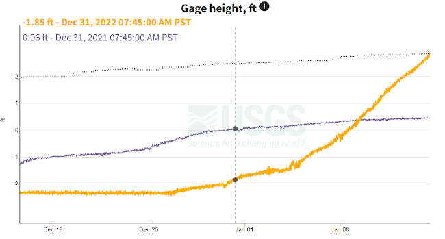
Figure. Lake Level data for the period of December 14, 2022 - January 14, 2023 (Orange) compared to historic median (dotted line on top) for the last previous 109 years (1913-2022) and to the Lake level during the same period last year (purple). Source: USGS.
The lake, when full, will be 7.56 on the Rumsey gauge. As I write this article, the lake is currently at 2.84 Rumsey, so about 40% full. But remember, that we were below zero Rumsey in December, at about -2.25 Rumsey, until we started getting these rain events, so we had to get to zero first, before rain could start to fill the Lake to full.
However, if you notice the historic median lake level on the graph (dotted, top line), you will notice that we have met the historic median, making the lake level today very similar to the previous 109 years, with 50% of the years being more than that value and 50% being less (definition of median).
If you want to know stage height data from other gauges around the state, I suggest you explore the Sierra Nevada River Forcast Network Interactive Map. On this site, you can find different lakes or rivers with real-time gauges measuring lake levels, stream height and stream flow.
This also has a great interactive map, where you can see what gauges are where and what type of information they are collecting such as precipitation, stage height, flow, and some gauges also provide forecast conditions.
Also, the Lake County Water Resources Department monitors the daily lake level and can provide that to you by phone at 707-263-2344, if you do not have access to the website.
Streaming real-time stream data
There are lots of resources available online for anyone to access real-time stream and river data. Please refer to my previous column, “Lady of the Lake: Streaming stream and river data in real-time” from October 31, 2021.
In that column, I reviewed two of my favorite websites for accessing stream data, including The California Nevada River Forecast Center, the CNRFC, and California Data Exchange Network, or CDEC.
The CNRFC, is a field office of the National Weather Service located in Sacramento, California. The CNRFC is co-located with the Sacramento NWS Forecast Office, CDWR, and United States Bureau of Reclamation. The NWS is an agency of the National Oceanic Atmospheric and Administration, or NOAA, under the United States Department of Commerce.
The CNRFC is great for monitoring flash flooding, river forecasting, managing water resources, or learning about hydrometeorology. Also the maps and graphs are very easy to use and interpret. This site can also provide temperature conditions and predictions which can be used for frost protection planning, for example. Additionally, this site has incorporated some post-fire debris flow warning layers. So if you live in an area that has a burn scar nearby, this website can help you to visualize those areas most at risk to post-fire flooding and debris flows.
The next resource is California Data Exchange Center, or CDEC. This website is managed by the California Department of Water Resources and while it does have some prediction power, the majority of gauge information here is real-time and archival. However, it’s pretty easy to use and has a large network of gauges and data that expands across all of California.
One thing about the CDEC is the data is focused on river information. The tabs at the top of the home page provide a lot of the type of data and tools available, and makes it easy to search for what you might need. Historic water data is also easily available on CDEC, making it easy to conduct a study on your local stream or river.
One thing to be aware of with CDEC is that the website can get pretty busy and bogged down during popular use times. If there is a heavy storm event and people and agencies are looking for river data and flood conditions, this website might get really slow and pages might not load as quickly, so be patient.
In my previous column on stream data, I provided a video tutorial on how to access CNRFC data from your own computer. This video is very useful for someone who has no prior experience getting stream data from online resources.
Stream and Lake gauges in our area
Here I provide some of the quick links for the local gauges for streams and lakes of interest.
Below is a list of some *NEW* stream gauges installed this year thanks to the Blue Ribbon Committee for the Rehabilitation of Clear Lake Funds with partnerships from USGS, UC Davis, County of Lake Water Resources, Habematolel Pomo of Upper Lake, and City of Clearlake. These gagues are temporary but when fully operational will report stage height, flow, water temperature, and turbidity (how cloudy the water is).
Now, to answer your last question Randy; how much rain does it take to raise Clear Lake levels and how much is too much rain, or will result in flooding conditions.
It’s kinda remarkable that a month ago we were worried about another year of severe drought and now we are talking about flooding, but that is the new climate paradigm we are living in.
If you read my previous column about streaming stream data, you will notice that I refer to myself as a “data snob” because I like data clean, organized, and I like to use data to answer interesting questions. Randy, your question is very interesting to me, and I researched what was out there when it came to how much rain corresponds to a rise in lake level.
I got several answers, in conversations with folks who have lived here on the lake a long time. The most common answer was that every 4-5 inches of rain, we see about a foot of lake level increase. So, if we got 10 inches of rain, we would expect to see about 2 feet of lake level increase.
Logistically, the lake is rising from the rain itself (collecting in the lake) and the collection of runoff from the landscape and tributaries flowing into the lake contributes to the lake level increase.
Me, being a data snob, needed to see the numbers. Unfortunately for me, I am not an engineer and don’t have an engineering brain, but I dusted off my old mental file of math and algebra and attempted to understand the relationship between the rain and lake level rise. Full acknowledgement to Mr. Blackwell, my high school Algebra teacher - you were right, sometimes we do use this stuff in real life, Mr. B!
First I downloaded daily rain data from CDEC for Lake County, CA. The closest station with daily accumulated rain was the Whispering Pines (WSP, CA Dept of Water Resources/DFM-Hydro-SMN). For these purposes I used accumulated rain, and I converted the data to start from zero in December, as opposed to 10 inches accumulated for the entire water year which runs from October to September. I chose December because that is when we first started getting rain for this series of rain “events” and started seeing significant lake level rise.
I didn’t want to include accumulated rain from earlier in the year, for example from mild showers in October, to interfere with my calculations today, as that rain is probably, most likely, not contributing to lake levels we are seeing now.
Then I downloaded daily lake level data, from the Lakeport gauge station housed at Vector Control, as described above in the beginning of this column. Then I plotted both of these data on a scatter plot, with rain on the X axis (independent variable) and lake level rise on the Y axis (dependent variable). Then I calculated the slope of the data and fit a line to the slope.
Heads up, algebra alert, to calculate the slope of a line, or the “rise over run” of a line, we have to use the formula m=(y2-y1)/(x2-x1), with m= slope, x1 and x2 being two numbers in a list of x (rain) and ya and y2 being two numbers in the list of y (lake level). This is also described as the change in the y values over the change in the x values. The slope will answer the question; how much change in lake level will we see when we have one inch of rain?
A key piece to remember is that up until Zero Rumsey water is only going into the system, there is no outflow from the lake until the lake level gets to Zero Rumsey and only after that can water start to flow over the Grigsby Riffle in Cache Creek.
So this added another variable into my calculations and plot, even though we are still getting quite a bit of rain, we also are seeing water leave the system. So, here we go algebra again, I calculated a separate slope for when the lake is over zero Rumsey, to account for the precipitation, inflow from tributaries, and outflow into and down Cache Creek.
To my surprise (but not really) the slopes are pretty different. The slope for the rain-lake level relationship before zero Rumsey is 0.14 and the slope for after the lake is above zero Rumsey is 0.26. This means that for every one inch of rain, the lake rises about 0.14 feet or 0.26 feet, depending on if there is outflow or not. So it does take roughly 4 inches of rain to raise the lake one foot - when the lake is at or above zero Rumsey.
It takes quite a bit more rain (about 7 inches) to raise the lake one foot when the lake is negative Rumsey. Mathematically this might not make sense and you might be asking yourself “if water is leaving the system down Cache Creek, how can it take less rain to raise the lake?” And I would answer by asking you to consider the system as a part of the watershed in a post-drought year (of which my data is based).
It takes a lot of rain to infiltrate and soak into the soils, and then it takes a lot more to accumulate into runoff that flows into the lake. Another thing to consider is that the outflow to Cache Creek is very limited, at about 2,500 cubic feet per second (CFS), compared to a single inflowing tributary such as Middle Creek, which can easily reach 3,000 - 5,000 CFS in any given large storm event.
Lasty, Randy, you asked when we should see a “full lake”. The lake is considered full when it reaches 7.56 on the Rumsey gauge, and I estimated that if it receives 45 inches of rain (based on the slope for positive Rumsey) we should be at full lake status. This is about 55 annual accumulation from October.
We have quite a bit to go as we have received about 25 inches in the last three weeks and we are only 40% full. You also asked about flood stage, and I have been receiving lots of inquiries about that too.
How much rain does it take to raise Clear Lake? It depends on if the lake is below or above zero Rumsey. Red data points and slope equation is based on rain and lake level data from Dec 23, 2022 to January 8, 2023. Black data points and slope equation derived from rain and lake level data from Jan. 9 to 13, 2023. Rain data sourced from DWR CDEC WSP Station and Clear Lake level data from USGS Lakeport station 11450000.
According to USGS, and based on 109 years of historic lake levels, when the lake gets to 9 ft Rumsey, it's considered minor flood stage, 11.4 ft is moderate flood stage and major flood stage is when the lake is at or exceeds 12 ft Rumsey. According to the Lake County Water Resources Department Historical Levels of Clear Lake High and Low, there is 10% chance of getting to minor flood stage, and 1% chance of the lake getting to major flood stage in any given year.
Using my rudimentary slope calculations, I have calculated how much rain (continuous, mind you) we would need to get to those stages. This is estimated and only applies with the continuation of the rain series we are seeing. If we see a dry month, the trend might be slightly off, but these are generally good guidelines as the ground is currently saturated and the lake is likely to stay above zero Rumsey.
It would take about 40 inches during this rain event to get to the minor flood stage of 9.0 feet Rumsey (50 annual accumulation from October) and about 52 inches (63 annual) to get to the major flood stage of 12.0 feet Rumsey. Notice that my calculated numbers are not based on annual accumulation (starting in October), but total for the rain events starting in December, as the annual year reset on January 1st.
That is quite a bit to go, but anything can happen in a third year of La Niña, as we have learned.
Sincerely,
Lady of the Lake
Angela De Palma-Dow is a limnologist (limnology = study of fresh inland waters) who lives and works in Lake County. Born in Northern California, she has a Master of Science from Michigan State University. She is a Certified Lake Manager from the North American Lake Management Society, or NALMS, and she is the current president/chair of the California chapter of the Society for Freshwater Science. She can be reached at This email address is being protected from spambots. You need JavaScript enabled to view it..
LAKE COUNTY, Calif. — The Clearlake City Council this week will honor volunteers, get an update from a recreation task force and consider supporting the renewal of the county’s tourism improvement district.
The council will meet at 6 p.m. Jan. 19, in the council chambers at Clearlake City Hall, 14050 Olympic Drive.
Comments and questions can be submitted in writing for City Council consideration by sending them to City Clerk Melissa Swanson at This email address is being protected from spambots. You need JavaScript enabled to view it..
To give the council adequate time to review your questions and comments, please submit your written comments before 4 p.m. Thursday, Jan. 19.
Each public comment emailed to the city clerk will be read aloud by the mayor or a member of staff for up to three minutes or will be displayed on a screen. Public comment emails and town hall public comment submissions that are received after the beginning of the meeting will not be included in the record.
On Thursday, city staff will present January’s adoptable dogs and also give out certificates of appreciation for Breakfast with Santa volunteers.
Under council business, there will be an update on the Lake County Recreation Task Force.
The council also will consider approving a resolution granting consent to the county of Lake to renew the Lake County Tourism Improvement District, or LCTID, and include the city of Clearlake in the LCTID.
Council members also will review and approve the submittal of the fiscal year 2023-24 recognized obligation payment schedule for the period of July 1, 2023, through June 30, 2024.
On the meeting's consent agenda — items that are considered routine in nature and usually adopted on a single vote — are warrants; authorization of an amendment of contract with REY Engineers for the Tree Streets Design Project in the amount of $158,175; award of the Contract for the Youth Center flooring to Bridges Construction; continuation of authorization to implement and utilize teleconference accessibility to conduct public meetings pursuant to Assembly Bill 361; minutes of the Dec. 14, 2022, Lake County Vector Control District Board meeting; and authorization of an agreement with Studio W for city hall remodel services for a not-to-exceed amount of $130,916.
The council also will hold a closed session following the public portion of the meeting to discuss a liability claim filed against the city by David and Kimberly Cavagna.
Email Elizabeth Larson at This email address is being protected from spambots. You need JavaScript enabled to view it.. Follow her on Twitter, @ERLarson, or Lake County News, @LakeCoNews.
LAKEPORT, Calif. — A Lakeport man was arrested Sunday for a hit-and-run crash that injured a pedestrian.
Al James, 63, was arrested at about 10 a.m. Sunday, the Lakeport Police Department said.
Police officers were dispatched to the scene of a crash involving a vehicle and a pedestrian at a location on N. Main Street just before 6 p.m. Saturday evening.
The driver had fled the scene prior to the arrival of officers, authorities said.
The elderly female pedestrian, who was conscious and alert at the scene, was transported to Sutter Lakeside Hospital.
Police later reported that she was transported by air ambulance to an out-of-county hospital where she is recovering.
The only witnesses at the scene pointed law enforcement to a silver-colored larger SUV vehicle which was seen driving northbound on N. Main Street near the crash scene at the time of the collision.
On Sunday, police said they had apprehended James, originally a Texas resident.
He was booked into the Lake County Jail for felony hit-and-run, with bail set at $10,000.
Jail records indicated he was no longer in custody on Sunday night.
CLEARLAKE, Calif. — Praises of Zion Church and the Clearlake United Methodist Church have united to present the ninth annual Martin Luther King Unity Day.
The event will be held from noon to 2 p.m. Monday, Jan. 16, at the Clearlake Methodist Church, 14521 Pearl Ave.
The program includes unity speeches from a diverse group of people from different cultures, ethnicities, colors, socioeconomic backgrounds and gender identifications.
Local political leaders, churches, law enforcement, social agencies and state representatives have been invited.
There will be music and performances by local musicians, Pomo dancers and the African drum group.
Everyone in Lake County is encouraged to come to be a part of this “Unity Day.”
Organizers said It is vitally important for the well-being of our community and our country in these times of division and hate speech to come together as one world and on one accord.
The event is open to the entire county.
Please contact organizer Lynette Kirkwood at 707-461-9409 if you want to participate or would like more information.
MIDDLETOWN, Calif. — The Middletown Area Town Hall’s first meeting of the new year will feature the “state of the county” report from the district supervisor and the annual board election.
MATH will meet at 7 p.m. Thursday, Jan. 19, in the Middletown Community Meeting Room/Library at 21256 Washington St., Middletown. The meeting is open to the public.
To join the meeting via Zoom click on this link; the meeting ID is 659 964 1209. Call in at 669-900-6833.
The meeting will feature District 1 Supervisor Moke Simon, who will give his “state of the county” report. There will be a question and answer session afterward.
There also will be the MATH Board elections. Those who attend in person as well as those on Zoom can participate.
Once elected, the board of directors will nominate and elect officers — chair, vice chair and secretary — and the MATH Assembly will nominate and elect alternates.
MATH also will have a Zoom discussion.
The MATH Board includes Chair Monica Rosenthal, Vice Chair Ken Gonzalez, Secretary Todd Fiora, Rosemary Córdova and Bill Waite.
MATH — established by resolution of the Lake County Board of Supervisors on Dec. 12, 2006 — is a municipal advisory council serving the residents of Anderson Springs, Cobb, Coyote Valley (including Hidden Valley Lake), Long Valley and Middletown.
For more information email This email address is being protected from spambots. You need JavaScript enabled to view it..
Email Elizabeth Larson at This email address is being protected from spambots. You need JavaScript enabled to view it.. Follow her on Twitter, @ERLarson, or Lake County News, @LakeCoNews.
LUCERNE, Calif. — A meeting for Lucerne community members to discuss issues of concern will be held this week.
The Lucerne community meeting will take place at 6 p.m. Thursday, Jan. 19, in the multipurpose room at Lucerne Elementary School, 3351 Country Club Drive.
The meeting ID is 857 2312 7967, the passcode is 13931.
Kurt McKelvey, who has served as chair of the Lucerne Area Town Hall, will moderate the meeting.
On the agenda is a discussion of the Scotts Valley Band of Pomo Indians’ proposal to use the Lucerne Hotel to house dozens of out-of-county homeless youth and young adults.
The Lucerne Area Town Hall passed a resolution at its December meeting condemning the proposal.
Also on the agenda, there will be discussion for the need for self-determination for the community of Lucerne.
There also will be a discussion of neglected county maintenance issues in Lucerne.
Gov. Gavin Newsom on Saturday night announced that the White House has approved California’s request for a Presidential Major Disaster Declaration to support the state’s emergency response to ongoing storm impacts including flooding, mudslides and landslides in communities across the state.
“California is grateful for President Biden’s swift approval of this critical support to communities reeling from these ongoing storms,” said Governor Newsom, who earlier on Saturday met with evacuated residents in Merced County and surveyed damage in the area. “We’ll continue to work in lockstep with local, state and federal partners to help keep Californians safe and make sure our communities have the resources and assistance they need to rebuild and recover.”
The Presidential Major Disaster Declaration will help Californians in impacted counties through eligibility for several programs and supports, and includes public assistance to help state, tribal and local governments with ongoing emergency response and recovery costs and hazard mitigation.
Saturday’s declaration makes federal funding available to affected individuals in the counties of Merced, Sacramento and Santa Cruz. Additional impacted counties may be included once storm conditions allow state, local and federal officials to safely assess the scope of damage.
Earlier this week, President Biden approved the governor’s request for a Presidential Emergency Declaration to bolster state, local and tribal government storm response efforts.
Gov. Newsom has activated the State Operations Center to its highest level and proclaimed a state of emergency statewide.
Amid ongoing storms and flooding, the state and its partners are working quickly to initiate recovery efforts and help Californians return home as soon as it is safe to do so.
Work is underway to remove hazardous waste and clear debris and there are teams on the ground conducting damage assessments documenting the extent of the losses so that the state can maximize its requests for federal aid.
Residents and business owners who sustained losses in the designated areas can begin applying for assistance by registering online at www.DisasterAssistance.gov or by calling 1-800-621-3362 or 1-800-462-7585 TTY

 How to resolve AdBlock issue?