NORTHERN CALIFORNIA — This week the Yuba Community College District Board of Trustees will consider extending the contract of the interim dean of the Lake County Campus of Woodland Community College while the recruitment for the permanent dean continues.
The board will meet at 3 p.m. Thursday, April 11, for a closed session before the open session begins at 5 p.m. at Yuba College’s Building 300, 2088 N. Beale Road, Marysville.
The meeting also will be available via Zoom. The call-in number is 1 669 900 6833, the Zoom meeting ID is 8.32 4748 3204
Staff is recommending board members approve the proposed employment extension of Patricia Barba, who has been acting as the Lake County Campus’ interim dean since the board approved her appointment in November, as Lake County News has reported.
Her annual salary is $113, 774 and the initial appointment was to continue through May 10.
The proposed extension will have Barba in the job until Nov. 8.
Meantime, the district is continuing its recruitment to find an individual to take the job on a permanent basis.
The closing date for the application is April 23.
In a March 28 email to area leaders, new Woodland Community College President Dr. Lizette Navarette reported that the job recruitment — dean of both the Lake County Campus and Colusa Center — was underway, with the job posted not just on the college website but on 10 different job sites.
Navarette also asked local leaders to share the position opening throughout their networks.
Email Elizabeth Larson at This email address is being protected from spambots. You need JavaScript enabled to view it.. Follow her on Twitter, @ERLarson, or Lake County News, @LakeCoNews.
LAKE COUNTY, Calif. — The Board of Supervisors will hold interviews for two department head positions this week.
The board will meet beginning at 9 a.m. Tuesday, April 9, in the board chambers on the first floor of the Lake County Courthouse, 255 N. Forbes St., Lakeport.
The meeting ID is 833 5785 4599, pass code 286739. The meeting also can be accessed via one tap mobile at +16699006833,,83357854599#,,,,*286739#. The meeting can also be accessed via phone at 669 900 6833.
At the start of Tuesday’s meeting, the board will meet the pet of the week and hear about what’s “New and Noteworthy” at the Lake County Library.
In untimed items, the board will consider the second amendment to an agreement between the county of Lake and Community Behavioral Health for specialty mental health services in the amount of $3,200,000 for fiscal years 2023-24, 2024-25 and 2025-26.
Appointments to the Child Care Planning and Development Council will be discussed as part of another untimed item.
During closed session, the board will hold interviews for two key department head positions — the directors of Social Services and Water Resources.
The full agenda follows.
CONSENT AGENDA
5.1: Approve second reading of ordinance amending Article XXVII of Chapter 2 of the Lake County Code to address membership of county of Lake Health Services in the existing Partnership HealthPlan of California Commission.
5.2: Approve closure of all Lake County Behavioral Health Services locations from noon to 5 p.m. on July 19 for a mandatory all staff training.
5.3: Approve Amendment No. 1 to the agreement between county of Lake and I.D.E.A. for consulting for professional consulting services in the amount of $31,000 for fiscal year 2023-2024 and authorize the chair to sign.
5.4: Approve waiver of the 900-hour extra help limitation for extra help office assistant, Kimberly Young for the fiscal year 2023-24.
5.5, Sitting as the Lake County Watershed Protection District, approve the cooperative agreement with Caltrans to provide Blue Lakes Safety Project Mitigation funds to support the Clover Creek Hitch Habitat Restoration Project in an amount not to exceed $246,492 and authorize the Water Resources director to sign the agreement, and (2) receive a presentation of the proposed project.
5.6: Approve agreement for the provision, installation, and maintenance of advanced network (data) services for an amount not to exceed $50,000 annually; and authorize the chair to sign.
5.7: Approve amendment to contract with Mendocino County for juvenile hall services in the amount of $100,000 annually and extend contract through June 2025; and authorize the chair to sign.
5.8: Adopt resolution accepting official canvass of the Presidential Primary Election held on March 5, 2024.
5.9: Approve contract between county of Lake and Prentice Long for public authority labor negotiation services, in the amount of $30,000 per year from Feb. 1, 2024, to Jan. 31, 2027, and authorize the chair to sign.
TIMED ITEMS
6.2, 9:03 a.m.: Pet of the Week.
6.3, 9:04 a.m.: New and Noteworthy at the Library.
UNTIMED ITEMS
7.2: Consideration of Amendment No. 2 to the agreement between the county of Lake and Community Behavioral Health for specialty mental health services in the amount of $3,200,000 for fiscal years 2023-24, 2024-25 and 2025-26.
7.3: Consideration of the following appointments to the Child Care Planning and Development Council and changes to membership assignments.
CLOSED SESSION
8.1: Public employee appointment pursuant to Gov. Code Section 54957(b) (1): Interviews for Social Services director; appointment of Social Services director.
8.2: Public employee appointment pursuant to Gov. Code Section 54957(b) (1): Interviews for Water Resources director; appointment of Water Resources director.
Email Elizabeth Larson at This email address is being protected from spambots. You need JavaScript enabled to view it.. Follow her on Twitter, @ERLarson, or Lake County News, @LakeCoNews.
Middle-aged Americans are lonelier than their European counterparts. That’s the key finding of my team’s recent study, published in American Psychologist.
Our study identified a trend that has been evolving for multiple generations, and affects both baby boomers and Gen Xers. Middle-aged adults in England and Mediterranean Europe are not that far behind the U.S. In contrast, middle-aged adults in continental and Nordic Europe reported the lowest levels of loneliness and stability over time.
We used survey data drawn from over 53,000 middle-aged adults from the U.S. and 13 European nations from 2002 to 2020. We tracked their reported changes in loneliness every two years across the midlife years of 45 to 65. This span provided us data from the so-called silent generation of people born between 1937 and 1945; baby boomers, born between 1946 and 1964; and members of Generation X, born between 1965 and 1974.
Our study makes clear that middle-aged Americans today are experiencing more loneliness than their peers in European nations. This coincides with existing evidence that mortality rates are rising for working-age adults in the U.S.
We focused on middle-aged adults for several reasons. Middle-aged adults form the backbone of society by constituting a majority of the workforce. But they also face increasing challenges today, notably greater demands for support from both their aging parents and their children.
Loneliness is considered a global public health issue. The U.S. surgeon general released an advisory report in 2023 documenting an epidemic of loneliness and a pressing need to increase social connection. Other nations, such as the U.K.and Japan, have appointed ministers of loneliness to ensure relationships and loneliness are considered in policymaking.
You can be lonely even when surrounded by people.
What still isn’t known
Why are middle-aged Americans exceptional when it comes to loneliness and poorer overall mental and physical health?
We did not directly test this in our study, but in the future we hope to zero in on the factors driving these trends. We think that the loneliness Americans are reporting compared to peer nations comes down to limited social safety nets and to cultural norms that prioritize individualism over community.
Individualization carries psychological costs, such as reductions in social connections and support structures, which are correlates of loneliness. Relative to the other nations in our study, Americans have a higher tendency to relocate, which is associated with weak social and community ties.
One of the reasons why we chose countries from across Europe is that they differ dramatically from the U.S. when it comes to social and economic opportunities and social safety nets. Social and economic inequalities likely increase one’s loneliness through undermining one’s ability to meet basic needs. Generous family and work policies likely lessen midlife loneliness through reducing financial pressures and work-family conflict, as well as addressing health and gender inequities.
Our findings on loneliness in conjunction with previous studies on life expectancy, health, well-being and cognition suggest that being middle-aged in America is a risk factor for poor mental and physical health outcomes.
The Research Brief is a short take on interesting academic work.
CalHFA Executive Director Tiena Johnson Hall. Courtesy photo. LAKE COUNTY, Calif. — The latest round of a state-funded housing program will help low- to moderate-income households in California achieve the dream of homeownership and create more generational wealth, while also providing ongoing funding for future homebuyers.
Round 2 of the California Dream For All Shared Appreciation Loan program, which offers first-generation homebuyers up to 20% of their home purchase price in down payment assistance, will be using a random selection process to facilitate the equitable distribution of $250 million in state funds.
CalHFA, which oversees other successful down payment and mortgage assistance programs, is accepting applications for Dream For All Vouchers through April 29.
In the weeks after the application window closes, applications will be drawn and audited, and voucher recipients will have 90 days to shop for a home.
“The California Dream For All program is all about opening doors for first-generation homebuyers and offering more opportunities for future generations,” said CalHFA Executive Director Tiena Johnson Hall. “Homeownership has many financial benefits, from building equity that can help fund a college education to providing stable housing costs without the worry of rent increases.”
Voucher applicants will need to work with one of CalHFA’s Approved Lenders to get a Pre-Approval letter.
Applicants will also need a few other documents for submission, including a government-issued ID, proof of residence and other items. The complete list is located on the Dream For All webpage — www.calhfa.ca.gov/dream — along with other valuable program information.
The California Dream For All program addresses the challenge of buying a home in California in several ways.
First-generation homebuyers can receive a large enough down payment to eliminate the need for mortgage insurance and benefit from smaller monthly payments.
The California Dream For All program’s shared appreciation loan will save the average homebuyer about $1,200 per month, according to California Forward, a nonprofit policy advocacy organization that prepared a report on shared appreciation for the California State Treasurer’s Office in 2022.
All borrowers must meet CalHFA’s Dream For All income limits — about $132,000 in Fresno County, $155,000 in Los Angeles County and $287,000 in Santa Clara County.
This second round of California Dream For All aims to help between 1,600 and 2,000 households, and as those homeowners sell their homes or refinance their mortgages, the state will recover the down payment plus the 20% of the appreciation and recycle those funds in order to assist more homebuyers.
Clayton Buck, George M. Hayward and Lydia R. Anderson
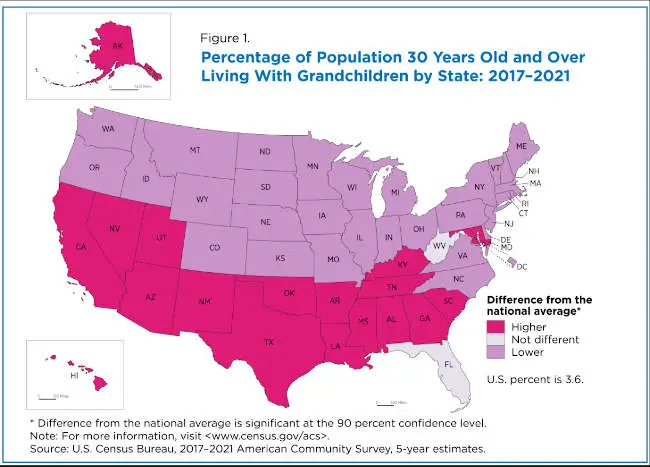
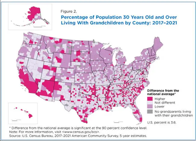
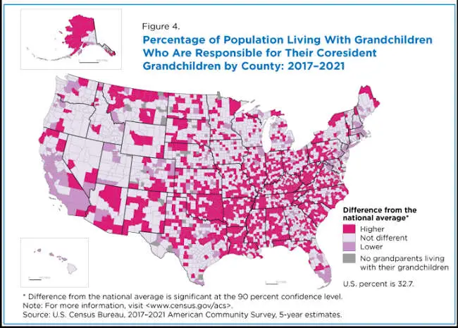
About 6.7 million people or 3.3% of adults age 30 and over lived with their grandchildren in 2021, according to a recently released U.S. Census Bureau report on the characteristics and geography of grandparents living with grandchildren under the age of 18 in the United States.
Alaska, Hawaii and states in the Southeast and Southwest had a higher share of grandparent-grandchildren households than the national average while states in the Northeast, Midwest and Pacific Northwest had lower shares.
Grandparents have long served critical roles in U.S. families that are shaped by changing demographic trends, such as increasing life expectancy, which allows grandparents more years to develop relationships with grandchildren.
Cultural expectations of the role of grandparents also contribute to differences in living arrangements.
States with highest share of grandparents living with grandchildren
Using 2017-2021 American Community Survey, 5-year estimates, Figure 1 shows the percentage of the population age 30 and over who lived with grandchildren under the age of 18 and whether the estimate for each state differed significantly from the national average.
The county-level map (Figure 2) offers an even more granular look at how these estimates vary. Some states, such as Connecticut, Iowa, Maine, Massachusetts, New Hampshire, Oregon, Rhode Island and Vermont had zero counties with percentages higher than the national average.
The geographic patterns reflect the demographics and cultural characteristics of people who live in those areas.
The South, for example, has a higher percentage of Black or African American populations in the region who have a relatively high rate of living with grandchildren.
Lower percentages in the Northeast and Midwest could reflect higher percentages of non-Hispanic White populations, who have among the lowest percentage of grandparents living with grandchildren.
The high percentages of grandparents living with grandchildren throughout Alaska and Hawaii reflect the higher percentages of American Indian and Alaska Native (AIAN) and Native Hawaiian and Other Pacific Islander (NHPI) populations, respectively. Both groups (AIAN and NHPI) have among the highest percentages living with grandchildren.
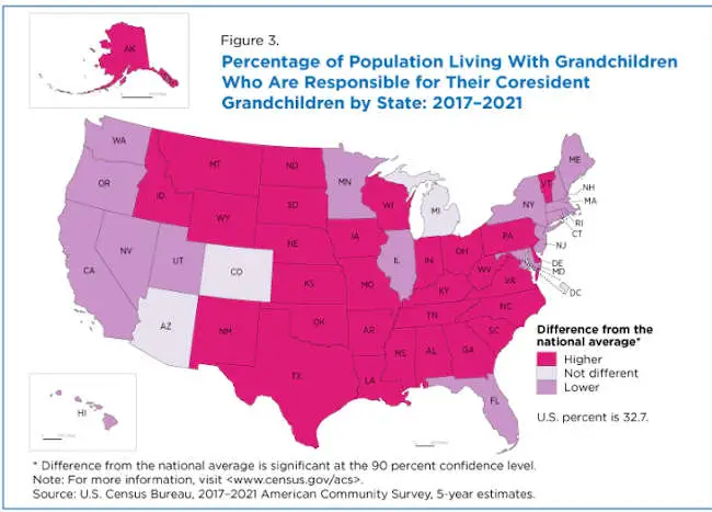
Grandparents caring for grandchildren
Nationally, roughly 32.7% of grandparents living with their grandchildren under the age of 18 were responsible for their care (Figure 3).
With the exception of the District of Columbia, Florida and Maryland, states in the South had higher percentages than the national average while states on the West Coast tended to have lower percentages. Alaska was higher and Hawaii was lower than the national average.
Arizona, Colorado, the District of Columbia and Michigan were the only states or state equivalents with estimates that were not significantly different from the national average.
Figure 4 shows county-level geographic variation. Some states, such as Hawaii, New Jersey, Rhode Island and Utah, had zero counties with percentages higher than the national average. On the other end of the spectrum, Arkansas, Delaware, Kentucky, Louisiana, New Mexico, Oklahoma, South Carolina and Wyoming did not have a single county lower than the national average.
Several states had a higher share of the population 30 years and over living with grandchildren (Figure 1) than the national average but a lower share of those living with grandchildren who were responsible for their grandchildren (Figure 3).
For example, the share of grandparents living with grandchildren exceeded the national average in California, Hawaii, Maryland, Nevada and Utah (Figure 1), but the share of those responsible for their grandchildren’s care was lower than the national average in those states (Figure 3).
The opposite was true in 16 states: Idaho, Indiana, Iowa, Kansas, Missouri, Montana, Nebraska, North Carolina, North Dakota, Ohio, Pennsylvania, South Dakota, Vermont, Virginia, Wisconsin and Wyoming. In those states, the percentage of grandparents living with grandchildren was lower than the nation as a whole but the share of those responsible for the care of their grandchildren was higher.
Clayton Buck and Lydia R. Anderson are family demographers in the U.S. Census Bureau’s Social, Economic, and Housing Statistics Division’s Fertility and Family Statistics Branch. George M. Hayward is a family demographer in the Census Bureau’s Population Division’s Population Estimates Branch.
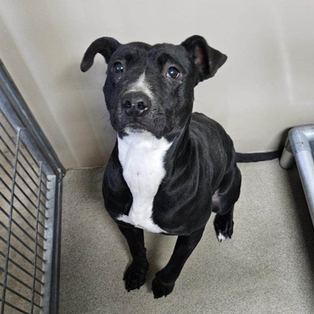
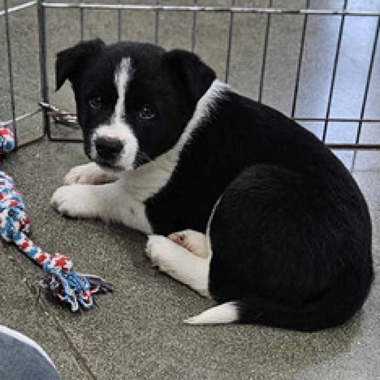
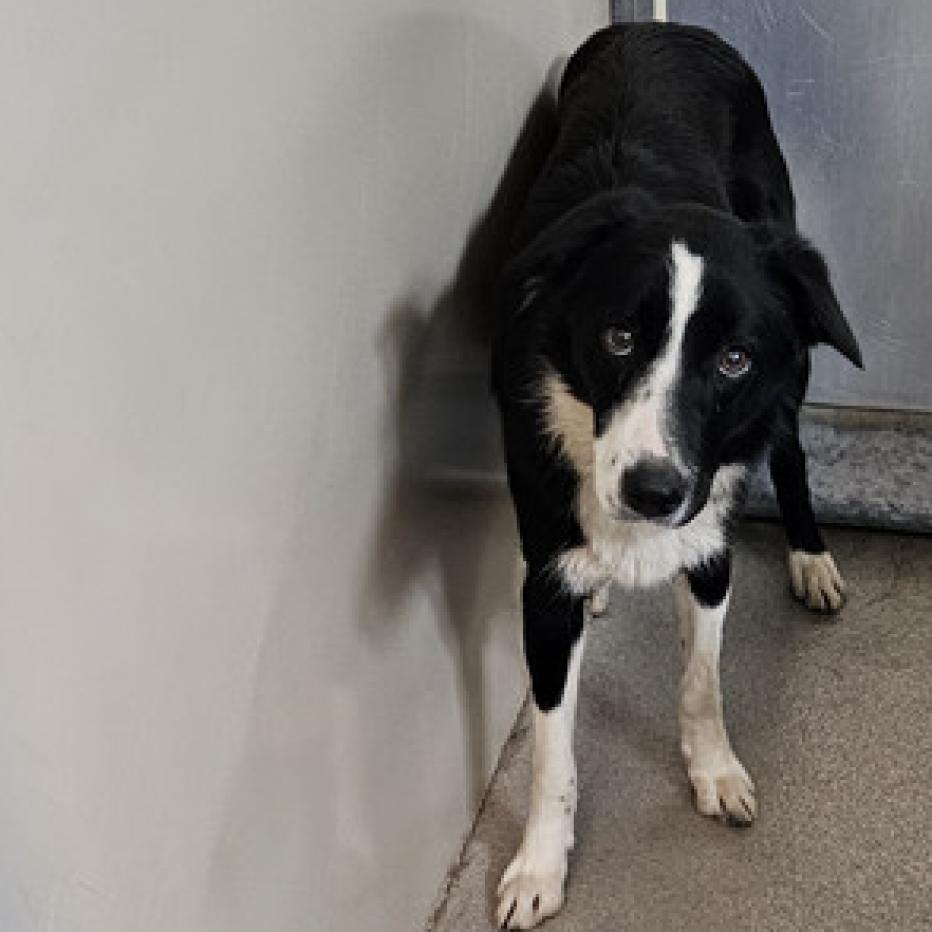
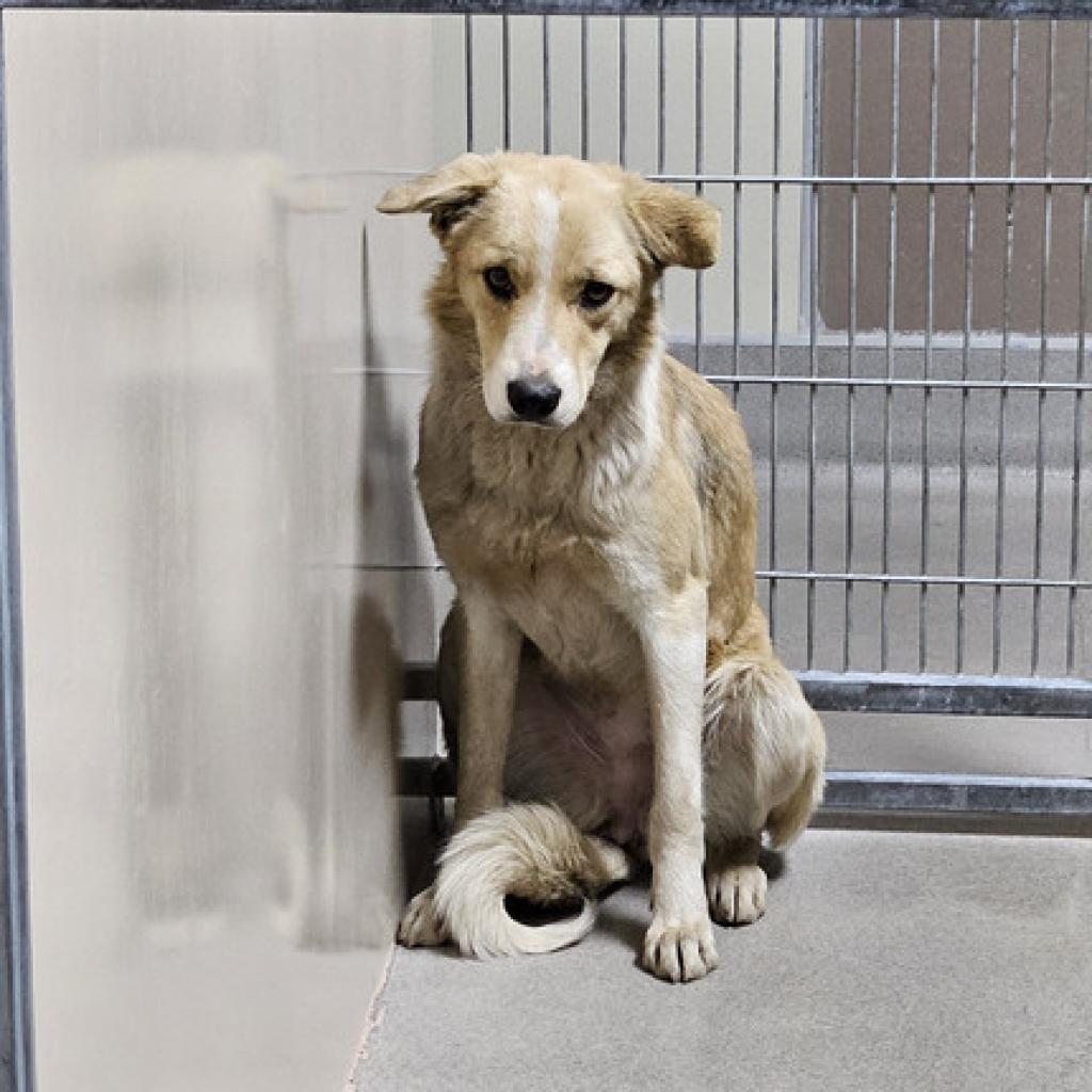
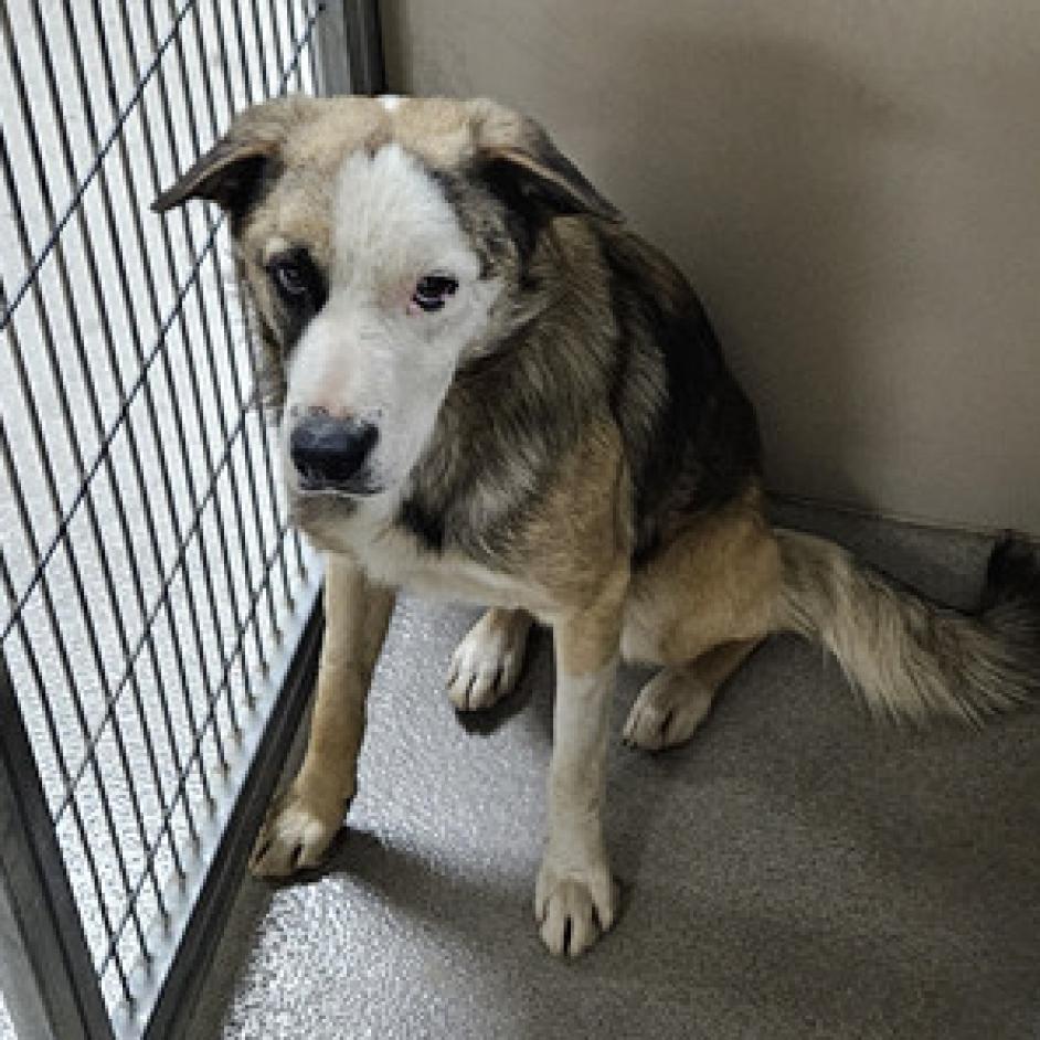
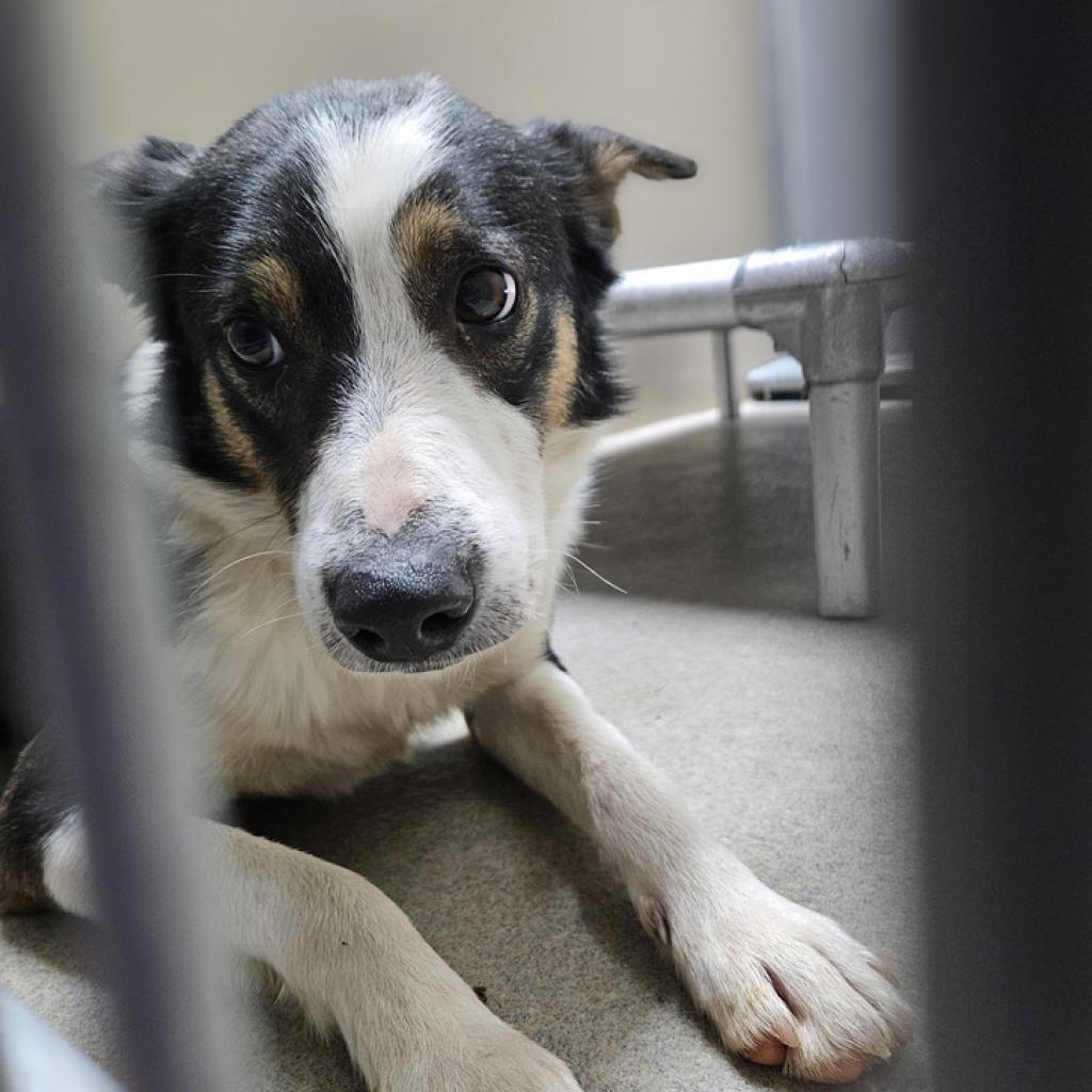
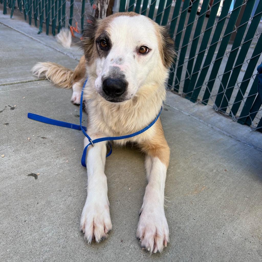
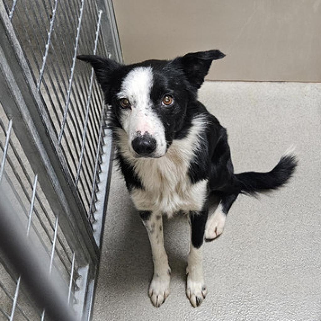
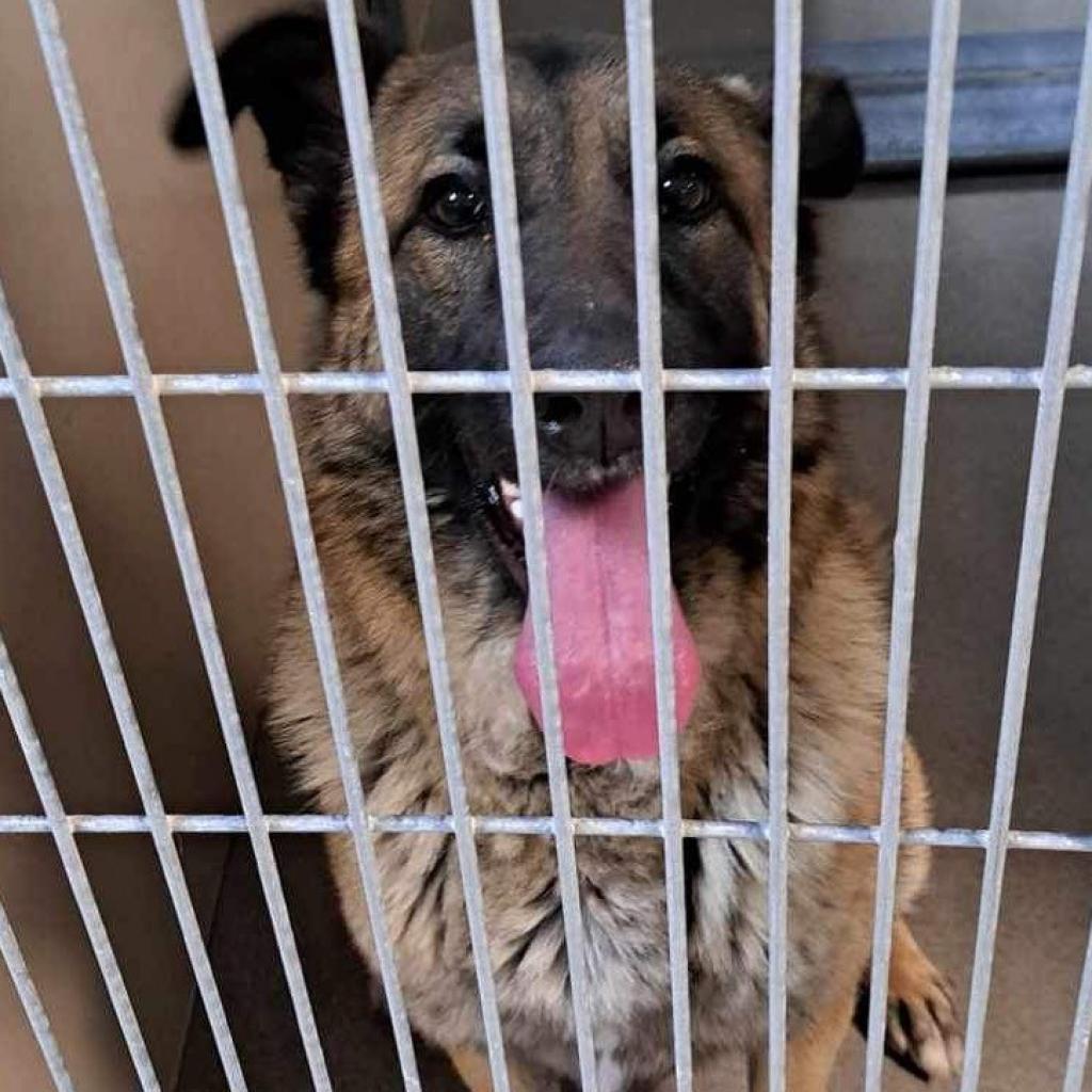
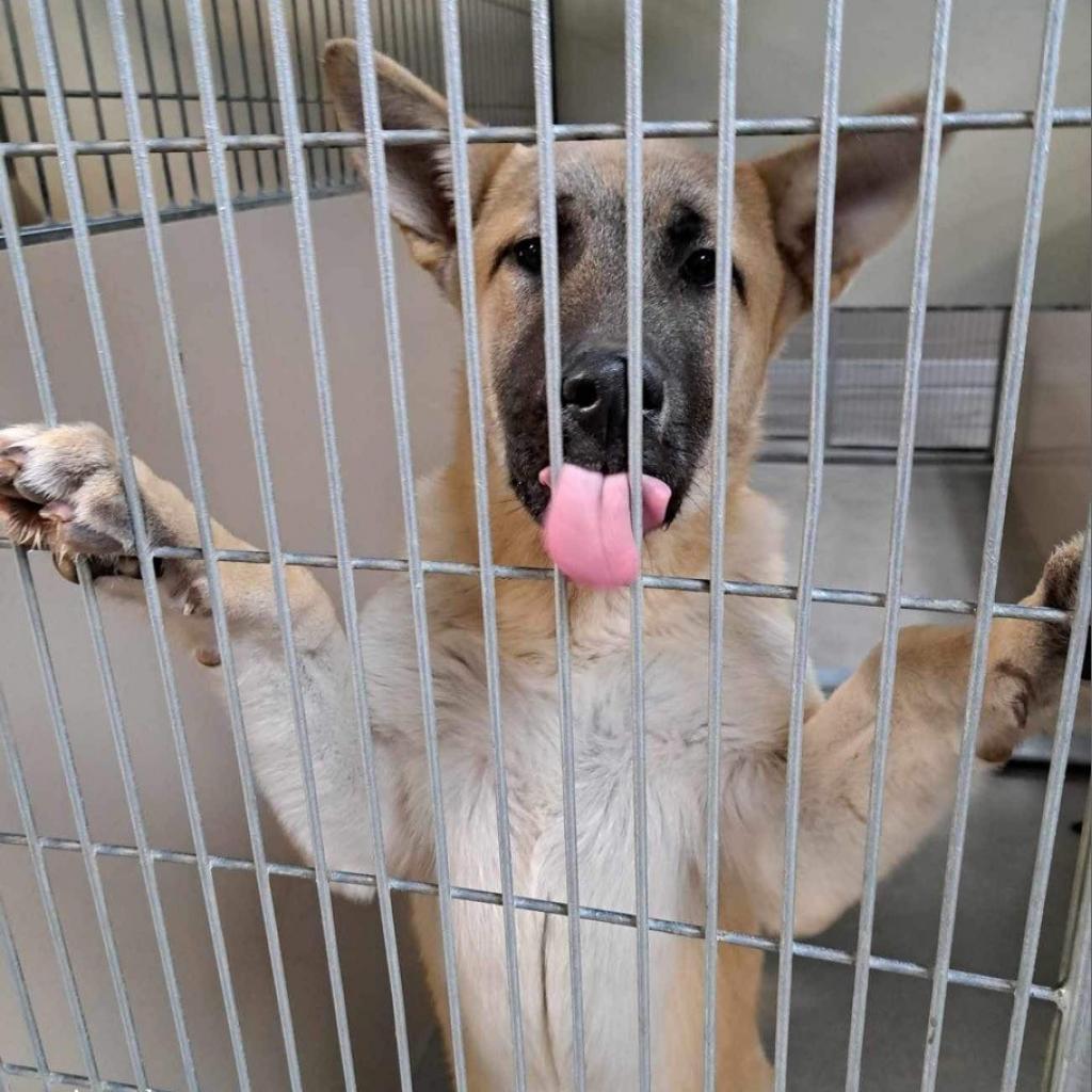
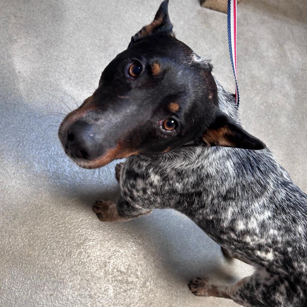
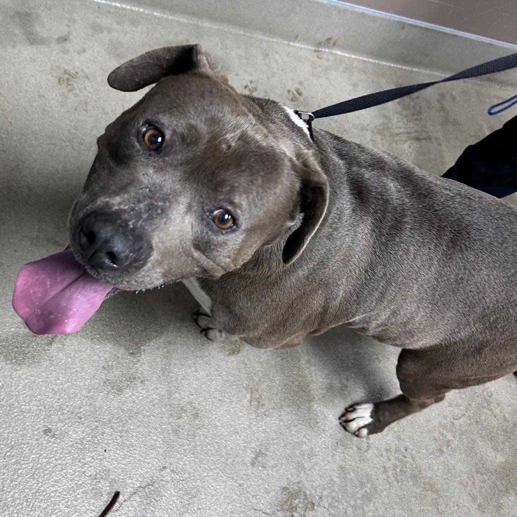
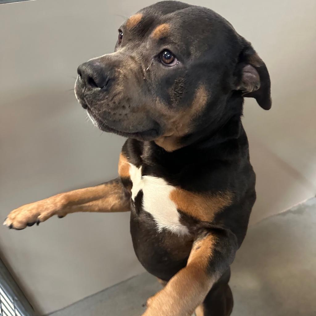
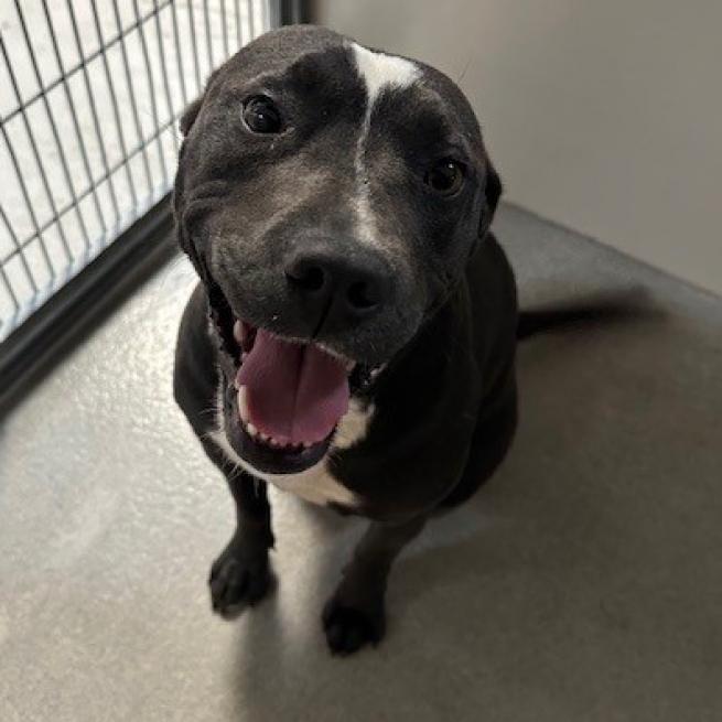
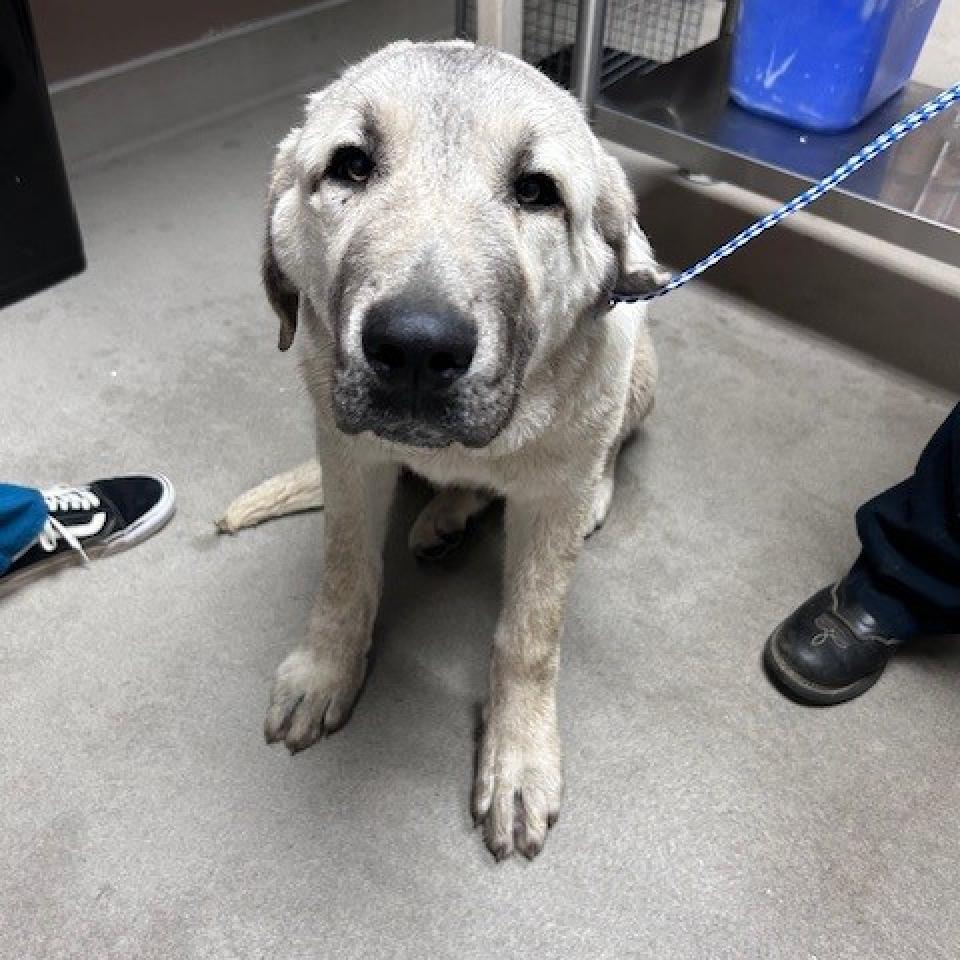
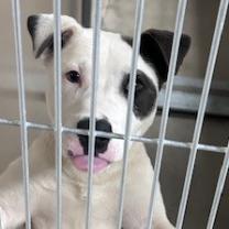
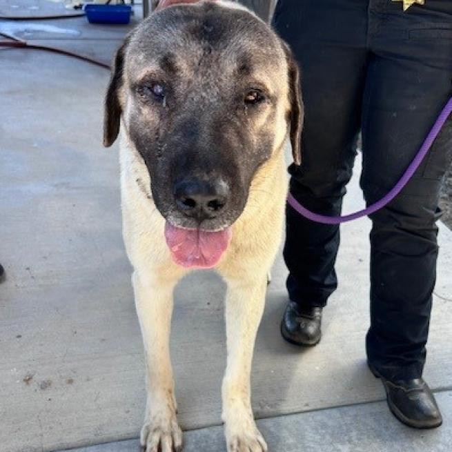
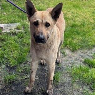
LAKE COUNTY, Calif. — Lake County Animal Care and Control has many new dogs needing homes this week.
Dogs available for adoption this week include mixes of Alaskan husky, American blue heeler, Anatolian shepherd, border collie, German shepherd, Great Pyrenees, Labrador Retriever, pit bull terrier, Rottweiler and Weimaraner.
Dogs that are adopted from Lake County Animal Care and Control are either neutered or spayed, microchipped and, if old enough, given a rabies shot and county license before being released to their new owner. License fees do not apply to residents of the cities of Lakeport or Clearlake.
Those dogs and the others shown on this page at the Lake County Animal Care and Control shelter have been cleared for adoption.
Call Lake County Animal Care and Control at 707-263-0278 or visit the shelter online for information on visiting or adopting.
The shelter is located at 4949 Helbush in Lakeport.
Email Elizabeth Larson at This email address is being protected from spambots. You need JavaScript enabled to view it.. Follow her on Twitter, @ERLarson, or Lake County News, @LakeCoNews.
NORTHERN CALIFORNIA — The FireScape Mendocino Core Team invites community members and landowners to join an in-person workshop “Taking Action: Celebrating 10 Years of Collaboration.”
The workshop will be held on Thursday, April 25, from 1:30 to 7:30 p.m.
Private landowners, land managers, user groups, tribes, elected officials, businesses and community members will explore ways to help shape experiences on the fire-prone landscape in and around Mendocino National Forest.
Speakers will discuss past and current FireScape Mendocino projects and collaborations that address fire resilience, recreation, and jobs on the landscape.
Participants are invited to assist with developing solutions for resource challenges.
FireScape Mendocino is a collaborative of private citizens and public organizations focused on creating more fire-resilient landscapes in and around the Mendocino National Forest.
This is the 15th workshop hosted by the organization.
The workshop will be held at Granzella’s Banquet Hall, 457 Seventh St., Williams. Light refreshments and a buffet dinner will be provided for all who register in advance.
The workshop is free and open to the public. Participants should register in advance no later than April 17 at https://forms.office.com/g/FWsWsyBUrj.
FireScape Mendocino is a voluntary, inclusive and collaborative effort to shape the future of our fire-prone landscape in and near the Mendocino National Forest.
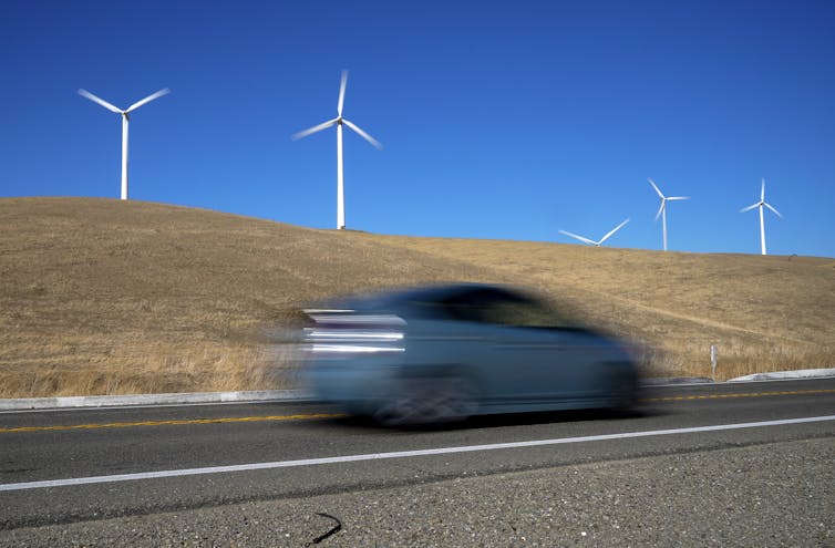
Panasonic’s new US$4 billion battery factory in De Soto, Kansas, is designed to be a model of sustainability – it’s an all-electric factory with no need for a smokestack. When finished, it will cover the size of 48 football fields, employ 4,000 people and produce enough advanced batteries to supply half a million electric cars per year.
But there’s a catch, and it’s a big one.
While the factory will run on wind and solar power much of the time, renewables supplied only 34% of the local utility Evergy’s electricity in 2023.
In much of the U.S., fossil fuels still play a key role in meeting power demand. In fact, Evergy has asked permission to extend the life of an old coal-fired power plant to meet growing demand, including from the battery factory.
The Kansas battery plant highlights the challenges ahead as the U.S. scales up production of clean energy technologies and weans itself off fossil fuels. It also illustrates the potential for this industry to accelerate the transition to renewable energy nationwide.
The clean tech manufacturing boom
Let’s start with some good news.
In the battery sector alone, companies have announced plans to build 44 major factories with the potential to produce enough battery cells to supply more than 10 million electric vehicles per year in 2030.
That is the scale of commitment needed if the U.S. is going to tackle climate change and meet its new auto emissions standards announced in March 2024.
The challenge: These battery factories, and the electric vehicles they equip, are going to require a lot of electricity.
Producing enough battery cells to store 1 kilowatt-hour (kWh) of electricity – enough for 2 to 4 miles of range in an EV – requires about 30 kWh of manufacturing energy, according to a recent study.
Combining that estimate and our tracking, we project that in 2030, battery manufacturing in the U.S. would require about 30 billion kWh of electricity per year, assuming the factories run on electricity, like the one in Kansas. That equates to about 2% of all U.S. industrial electricity used in 2022.
However, we have also been tracking which battery companies are committing to powering their manufacturing operations with renewable electricity, and the data points to a cleaner future.
By our count, half of the batteries will be manufactured at factories that have committed to sourcing at least 50% of their electricity demand from renewables by 2030. Even better, these commitments are concentrated in regions of the U.S. where investments have lagged.
Some companies are already taking action. Tesla is building the world’s largest solar array on the roof of its Texas factory. LG has committed to sourcing 100% renewable solar and hydroelectricity for its new cathode factory in Tennessee. And Panasonic is taking steps to reach net-zero emissions for all of its factories, including the new one in Kansas, by 2030.
More corporate commitments can help strengthen demand for the deployment of wind and solar across the emerging battery belt.
What that means for US electricity demand
Manufacturing all of these batteries and charging all of these electric vehicles is going to put a lot more demand on the power grid. But that isn’t an argument against EVs. Anything that plugs into the grid, whether it is an EV or the factory that manufacturers its batteries, gets cleaner as more renewable energy sources come online.
This transition is already happening. Although natural gas dominates electricity generation, in 2023 renewables supplied more electricity than coal for the first time in U.S. history. The government forecasts that in 2024, 96% of new electricity generating capacity added to the grid would be fossil fuel-free, including batteries. These trends are accelerating, thanks to the incentives for clean energy deployment included in the 2022 Inflation Reduction Act.
Looking ahead
The big lesson here is that the challenge in Kansas is not the battery factory – it is the increasingly antiquated electricity grid.
As investments in a clean energy future accelerate, America will need to reengineer much of its power grid to run on more and more renewables and, simultaneously, electrify everything from cars to factories to homes.
That means investing in modernizing, expanding and decarbonizing the electric grid is as important as building new factories or shifting to electric cars.
Investments in clean energy manufacturing will play a key role in enabling that transition: Some of the new advanced batteries will be used on the grid, providing backup energy storage for times when renewable energy generation slows or electricity demand is especially high.
In January, Hawaii replaced its last coal-fired power plant with an advanced battery system. It won’t be long before that starts to happen in Tennessee, Texas and Kansas, too.
Most birds that flit through dense, leafy forests have a strategy for maneuvering through tight windows in the vegetation — they bend their wings at the wrist or elbow and barrel through.
But hummingbirds can't bend their wing bones during flight, so how do they transit the gaps between leaves and tangled branches?
A study published today in the Journal of Experimental Biology shows that hummingbirds have evolved their own unique strategies — two of them, in fact. These strategies have not been reported before, likely because hummers maneuver too quickly for the human eye to see.
For slit-like gaps too narrow to accommodate their wingspan, they scooch sideways through the slit, flapping their wings continually so as not to lose height.
For smaller holes — or if the birds are already familiar with what awaits them on the other side — they tuck their wings and coast through, resuming flapping once clear.
“For us, going into the experiments, the tuck and glide would have been the default. How else could they get through?” said Robert Dudley, a professor of integrative biology at the University of California, Berkeley, and senior author of the paper. “This concept of sideways motion with a total mix-up of the wing kinematics is quite amazing — it's a novel and unexpected method of aperture transit. They're changing the amplitude of the wing beats so that they're not dropping vertically when they do the sideways scooch.”
Using the slower sideways scooch technique may allow birds to better assess upcoming obstacles and voids, thereby reducing the likelihood of collisions.
“Learning more about how animals negotiate obstacles and other 'building-blocks' of the environment, such as wind gusts or turbulent regions, can improve our overall understanding of animal locomotion in complex environments,” noted first author Marc Badger, who obtained his Ph.D from UC Berkeley in 2016. “We still don't know very much about how flight through clutter might be limited by geometric, aerodynamic, sensory, metabolic or structural processes. Even behavioral limitations could arise from longer-term effects, such as wear and tear on the body, as hinted at by the shift in aperture negotiation technique we observed in our study.”
Understanding the strategies that birds use to maneuver through a cluttered environment may eventually help engineers design drones that better navigate complex environments, he noted.
“Current remote control quadrotors can outperform most birds in open space across most metrics of performance. So is there any reason to continue learning from nature?” said Badger. “Yes. I think it's in how animals interact with complex environments. If we put a bird's brain inside a quadrotor, would the cyborg bird or a normal bird be better at flying through a dense forest in the wind? There may be many sensory and physical advantages to flapping wings in turbulent or cluttered environments.”
Obstacle course
To discover how hummingbirds — in this case, four local Anna’s hummingbirds (Calypte anna) — slip through tiny openings, despite being unable to fold their wings, Badger and Dudley teamed up with UC Berkeley students Kathryn McClain, Ashley Smiley and Jessica Ye.
“We set up a two-sided flight arena and wondered how to train birds to fly through a 16-square- centimeter gap in the partition separating the two sides,” Badger said, noting that the hummingbirds have a wingspan of about 12 centimeters (4 3/4 inches). “Then, Kathryn had the amazing idea to use alternating rewards.”
That is, the team placed flower-shaped feeders containing a sip of sugar solution on both sides of the partition, but only remotely refilled the feeders after the bird had visited the opposite feeder. This encouraged the birds to continually flit between the two feeders through the aperture.
The researchers then varied the shape of the aperture, from oval to circular, ranging in height, width and diameter, from 12 cm to 6 cm, and filmed the birds’ maneuvers with high-speed cameras. Badger wrote a computer program to track the position of each bird’s bill and wing tips as it approached and passed through the aperture.
They discovered that as the birds approached the aperture, they often hovered briefly to assess it before traveling through sideways, reaching forward with one wing while sweeping the second wing back, fluttering their wings to support their weight as they passed through the aperture. They then swiveled their wings forward to continue on their way.
“The thing is, they have to still maintain weight support, which is derived from both wings, and then control the horizontal thrust, which is pushing it forward. And they're doing this with the right and left wing doing very peculiar things,” Dudley said. “Once again, this is just one more example of how, when pushed in some experimental situation, we can elicit control features that we don't see in just a standard hovering hummingbird.”
Alternatively, the birds swept their wings back and pinned them to their bodies, shooting through — beak first, like a bullet — before sweeping the wings forward and resuming flapping once safely through.
“They seem to do the faster method, the ballistic buzz-through, when they get more acquainted with the system,” Dudley said.
Only when approaching the smallest apertures, which were half a wingspan wide, would the birds automatically resort to the tuck and glide, even though they were unfamiliar with the setup.
The team pointed out that only about 8% of the birds clipped their wings as they passed through the partition, although one experienced a major collision. Even then, the bird recovered quickly before successfully reattempting the maneuver and going on its way.
“The ability to pick among several obstacle negotiation strategies can allow animals to reliably squeeze through tight gaps and recover from mistakes,” Badger noted.
Dudley hopes to conduct further experiments, perhaps with a sequence of different apertures, to determine how birds navigate multiple obstacles.
The work was funded primarily by a CiBER-IGERT grant from the National Science Foundation (DGE-0903711).
Robert Sanders writes for the UC Berkeley News Center.
Pictured, from left to right, Marilyn Holdenried, Terry Dereniuk, Annette Hopkins and Sharron Zoller. Courtesy photo. LAKE COUNTY, Calif. — A Lake County resident who is a wine industry veteran has received a prestigious award that recognizes the contributions of women in agriculture.
Terry Dereniuk, a member of Lake County California Women for Agriculture, was awarded the Common Threads North Award at a ceremony in Chico on April 3.
Common Threads has annually honored the lives of outstanding Northern California women since 1997 through the combined efforts of a nonprofit committee made up of several strong agricultural organizations.
The women recognized, whose roots are deep in agriculture, have made a difference in their communities with bountiful giving of their time, talent and treasure. Agriculture is the common thread of all honorees.
Terry Dereniuk and her husband, Buz, farm an organic vineyard in Kelseyville.
In addition Terry Dereniuk has served as president of Kelseyville Rotary, is past executive director of the Lake County Winery Association and has written successful petitions to establish four new American Viticultural Areas, or AVAs, since 2011.
She sat on the Lake County Farm Bureau Board for 10 years and is the project manager for two grants in the Lake County wine industry.
She also serves on the Community Advisory Committee for Sutter Lakeside Hospital.
Past Lake County California Women for Agriculture chapter member recipients of the Common Threads North award are Toni Scully, Marilyn Holdenried and Sharron Zoller.
April is National Earthquake Preparedness Month, and this month state officials are sharing multilingual resources and calling on Californians to sign up for alerts through the state’s first-in-the-nation Earthquake Early Warning System to prepare for the next big one.
The MyShake App is now available in English, Spanish, Chinese (traditional), Vietnamese, Korean and Filipino.
Earthquake Warning California is the country’s first publicly available, statewide warning system giving California residents crucial seconds to Drop, Cover, and Hold On.
Sign up to get alerts to your phone as soon as shaking is detected by ground motion monitoring:
• MyShake App: Free smartphone app that provides iPhone and Android users with audio and visual warnings. • Local alerts. • Wireless Emergency Alerts (WEAs): No-cost text messages for emergency situations.
• Create a customized emergency plan for your specific needs • Build an emergency contact list • Build an emergency supply kit with copies of important documents
Know how to protect yourself during an earthquake: • DROP to the ground, COVER your head with your arms, and HOLD ON to your neck until shaking stops. • Remain vigilant for aftershocks.
Check in on family and friends after shaking stops:
• Reach out to your emergency contacts. • Check in with those in your community who may need additional assistance. • Listen to local authorities and official resources.
The Listos California campaign, which works to expand access to lifesaving emergency preparedness information, offers earthquake preparedness resources in several languages:
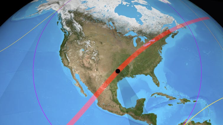
A total solar eclipse takes place on April 8 across North America. These events occur when the Moon passes between the Sun and Earth, completely blocking the Sun’s face. This plunges observers into a darkness similar to dawn or dusk.
During the upcoming eclipse, the path of totality, where observers experience the darkest part of the Moon’s shadow (the umbra), crosses Mexico, arcing north-east through Texas, the Midwest and briefly entering Canada before ending in Maine.
An international team of scientists, led by Aberystwyth University, will be conducting experiments from near Dallas, at a location in the path of totality. The team consists of PhD students and researchers from Aberystwyth University, Nasa Goddard Space Flight Center in Maryland, and Caltech (California Institute of Technology) in Pasadena.
There is valuable science to be done during eclipses that is comparable to or better than what we can achieve via space-based missions. Our experiments may also shed light on a longstanding puzzle about the outermost part of the Sun’s atmosphere – its corona.
The Sun’s intense light is blocked by the Moon during a total solar eclipse. This means that we can observe the Sun’s faint corona with incredible clarity, from distances very close to the Sun, out to several solar radii. One radius is the distance equivalent to half the Sun’s diameter, about 696,000km (432,000 miles).
Measuring the corona is extremely difficult without an eclipse. It requires a special telescope called a coronagraph that is designed to block out direct light from the Sun. This allows fainter light from the corona to be resolved. The clarity of eclipse measurements surpasses even coronagraphs based in space.
We can also observe the corona on a relatively small budget, compared to, for example, spacecraft missions. A persistent puzzle about the corona is the observation that it is much hotter than the photosphere (the visible surface of the Sun). As we move away from a hot object, the surrounding temperature should decrease, not increase. How the corona is heated to such high temperatures is one question we will investigate.
We have two main scientific instruments. The first of these is Cip (coronal imaging polarimeter). Cip is also the Welsh word for “glance”, or “quick look”. The instrument takes images of the Sun’s corona with a polariser.
The light we want to measure from the corona is highly polarised, which means it is made up of waves that vibrate in a single geometric plane. A polariser is a filter that lets light with a particular polarisation pass through it, while blocking light with other polarisations.
The Cip images will allow us to measure fundamental properties of the corona, such as its density. It will also shed light on phenomena such as the solar wind. This is a stream of sub-atomic particles in the form of plasma – superheated matter – flowing continuously outward from the Sun. Cip could help us identify sources in the Sun’s atmosphere for certain solar wind streams.
Direct measurements of the magnetic field in the Sun’s atmosphere are difficult. But the eclipse data should allow us to study its fine-scale structure and trace the field’s direction. We’ll be able to see how far magnetic structures called large “closed” magnetic loops extend from the Sun. This in turn will give us information about large-scale magnetic conditions in the corona.
The second instrument is Chils (coronal high-resolution line spectrometer). It collects high-resolution spectra, where light is separated into its component colours. Here, we are looking for a particular spectral signature of iron emitted from the corona.
It comprises three spectral lines, where light is emitted or absorbed in a narrow frequency range. These are each generated at a different range of temperatures (in the millions of degrees), so their relative brightness tells us about the coronal temperature in different regions.
Mapping the corona’s temperature informs advanced, computer-based models of its behaviour. These models must include mechanisms for how the coronal plasma is heated to such high temperatures. Such mechanisms might include the conversion of magnetic waves to thermal plasma energy, for example. If we show that some regions are hotter than others, this can be replicated in models.
This year’s eclipse also occurs during a time of heightened solar activity, so we could observe a coronal mass ejection (CME). These are huge clouds of magnetised plasma that are ejected from the Sun’s atmosphere into space. They can affect infrastructure near Earth, causing problems for vital satellites.
Many aspects of CMEs are poorly understood, including their early evolution near the Sun. Spectral information on CMEs will allow us to gain information on their thermodynamics, and their velocity and expansion near the Sun.
Our eclipse instruments have recently been proposed for a space mission called Moon-enabled solar occultation mission (Mesom). The plan is to orbit the Moon to gain more frequent and extended eclipse observations. It is being planned as a UK Space Agency mission involving several countries, but led by University College London, the University of Surrey and Aberystwyth University.
We will also have an advanced commercial 360-degree camera to collect video of the April 8 eclipse and the observing site. The video is valuable for public outreach events, where we highlight the work we do, and helps to generate public interest in our local star, the Sun.

 How to resolve AdBlock issue?


