LAKE COUNTY, Calif. — The Lakeport City Council this week will consider approval of a road safety plan and a contract for a project to make Hartley Street safer for pedestrians.
The council will meet at 6 p.m. Tuesday, March 1, in the council chambers at Lakeport City Hall, 225 Park St.
The council chambers will be open to the public for the meeting. In accordance with updated guidelines from the state of California, in-person attendees, regardless of vaccine status, are required to wear a face covering at this meeting.
If you cannot attend in person, and would like to speak on an agenda item, you can access the Zoom meeting remotely at this link or join by phone by calling toll-free 669-900-9128 or 346-248-7799.
The webinar ID is 973 6820 1787, access code is 477973; the audio pin will be shown after joining the webinar. Those phoning in without using the web link will be in “listen mode” only and will not be able to participate or comment.
Comments can be submitted by email to This email address is being protected from spambots. You need JavaScript enabled to view it.. To give the city clerk adequate time to print out comments for consideration at the meeting, please submit written comments before 3:30 p.m. on Tuesday, March 1.
Under council business, Public Works Superintendent Ron Ladd will ask the council to approve a local roadway safety plan and authorize the city manager, or designee, to implement the plan.
The council also will consider awarding a construction contract in the amount of $1,605,632 to Granite Construction Co. for the Hartley Street Pedestrian Improvement Project.
Ladd’s report to the council explains that the project will provide Americans with Disabilities Act-compliant access on Hartley Street from 20th Street to the east-side access of the school complex. It will result in 1,550 feet of new sidewalk, curb and gutter, new retaining walls, and flashing pedestrian warning signs near the school as part of this project.
In other business, City Manager Kevin Ingram will ask for the council’s approval of a memorandum of understanding to establish a cost sharing agreement with the county of Lake and city of Clearlake for community visioning forum facilitation.
The total agreement cost is $33,000, with the county of Lake to pay $22,500, the city of Clearlake $8,000 and the city of Lakeport $2,500.
On the consent agenda — items usually accepted as a slate on one vote — are ordinances; minutes of the council’s regular meeting on Feb. 1; adoption of a resolution authorizing continued remote teleconference meetings of the Lakeport City Council and its legislative bodies pursuant to Government Code section 54953(e); confirm the continuing existence of a local emergency for the COVID-19 Public Health Emergency; approval of event application 2022-009, with staff recommendations, for the 2022 Mental Health Matters Resource Fair; approval of event application 2022-010, with staff recommendations, for the 2022 Home Amateur Winemakers Winefest; and adoption of a resolution amending and adopting an updated Conflict of Interest Code.
Email Elizabeth Larson at This email address is being protected from spambots. You need JavaScript enabled to view it.. Follow her on Twitter, @ERLarson, or Lake County News, @LakeCoNews.
LAKE COUNTY, Calif. — Lake County Animal Care and Control has a number of new dogs arriving in its kennels this week.
Dogs available for adoption this week include mixes of Anatolian shepherd, Australian cattle dog, basset hound, German shepherd, Great Pyrenees, Rhodesian ridgeback, Shar-Pei, shepherd, pit bull and Weimaraner.
Dogs that are adopted from Lake County Animal Care and Control are either neutered or spayed, microchipped and, if old enough, given a rabies shot and county license before being released to their new owner. License fees do not apply to residents of the cities of Lakeport or Clearlake.
The following dogs at the Lake County Animal Care and Control shelter have been cleared for adoption (additional dogs on the animal control website not listed are still “on hold”).
Call Lake County Animal Care and Control at 707-263-0278 or visit the shelter online for information on visiting or adopting.
This 2-year-old male Weimaraner is in kennel No. 3, ID No. LCAC-A-2701. Photo courtesy of Lake County Animal Care and Control. Male Weimaraner
This 2-year-old male Weimaraner has a short gray coat.
He is in kennel No. 3, ID No. LCAC-A-2701.
This female German shepherd is in kennel No. 4, ID No. LCAC-A-2598. Photo courtesy of Lake County Animal Care and Control. Female German shepherd
This female German shepherd has a short black and tan coat.
She is in kennel No. 4, ID No. LCAC-A-2598.
This 5-year-old female shepherd mix is in kennel No. 9, ID No. LCAC-A-2793. Photo courtesy of Lake County Animal Care and Control. Female shepherd mix
This 5-year-old female shepherd mix has a tricolor coat.
She was in kennel No. 9, ID No. LCAC-A-2793.
This 7-year-old female shepherd mix is in kennel No. 10, ID No. LCAC-A-2792. Photo courtesy of Lake County Animal Care and Control. Female shepherd mix
This 7-year-old female shepherd mix has a tricolor coat.
She was in kennel No. 10, ID No. LCAC-A-2792.
“Ruby” is a 2-year-old female Shar-Pei-Rhodesian ridgeback mix in kennel No. 13, ID No. LCAC-A-2560. Photo courtesy of Lake County Animal Care and Control. ‘Ruby’
“Ruby” is a 2-year-old female Shar-Pei-Rhodesian ridgeback mix with a short tan coat.
She is in kennel No. 13, ID No. LCAC-A-2560.
This 2-year-old male pit bull in kennel No. 14, ID No. LCAC-A-2473. Photo courtesy of Lake County Animal Care and Control. Male pit bull
This 2-year-old male pit bull has a short black and white coat.
He is in kennel No. 14, ID No. LCAC-A-2473.
“Copper” is a young male basset hound in kennel No. 16, ID No. LCAC-A-2817. Photo courtesy of Lake County Animal Care and Control. ‘Copper’
“Copper” is a young male basset hound with a red and white coat.
He is in kennel No. 16, ID No. LCAC-A-2817.
This 2-year-old female Anatolian shepherd mix is in kennel No. 23, ID No. LCAC-A-2535. Photo courtesy of Lake County Animal Care and Control. Anatolian shepherd mix
This 2-year-old female Anatolian shepherd mix has a short tan coat with black markings.
She is in kennel No. 23, ID No. LCAC-A-2535.
This 2-year-old male Anatolian shepherd-Great Pyrenees is in kennel No. 26, ID No. LCAC-A-2536. Photo courtesy of Lake County Animal Care and Control. Anatolian shepherd-Great Pyrenees
This 2-year-old male Anatolian shepherd-Great Pyrenees has a short white coat.
He is in kennel No. 26, ID No. LCAC-A-2536.
This 1-year-old male Australian cattle dog is in kennel No. 28, ID No. LCAC-A-2754. Photo courtesy of Lake County Animal Care and Control. Australian cattle dog
This 1-year-old male Australian cattle dog has a short blue and black coat.
He is in kennel No. 28, ID No. LCAC-A-2754.
This 1-year-old female shepherd-Australian cattle dog mix is in kennel No. 33, ID No. LCAC-A-2534. Photo courtesy of Lake County Animal Care and Control. ‘Ginger’
“Ginger” is a 1-year-old female shepherd-Australian cattle dog mix with a cream and white coat.
She is in kennel No. 33, ID No. LCAC-A-2534.
Email Elizabeth Larson at This email address is being protected from spambots. You need JavaScript enabled to view it.. Follow her on Twitter, @ERLarson, or Lake County News, @LakeCoNews.
On Friday, Insurance Commissioner Ricardo Lara announced new regulations intended to improve wildfire safety and drive down the cost of insurance for homeowners and businesses.
Under the proposed regulations, which could be in effect by this summer, insurance companies would be required to factor consumers’ and businesses’ wildfire safety actions into their pricing of residential and commercial coverage.
The new regulations also will provide consumers with transparency about their “wildfire risk score” that insurance companies assign to properties.
These regulations address complaints Commissioner Lara heard from many consumers and businesses across the state that insurance companies are unwilling to account for steps taken to harden their properties and communities against wildfire, lowering their risk of loss and damage.
“With more Californians rolling up their sleeves and reaching into their own pockets to protect their homes and businesses, insurance pricing must reflect their efforts,” said Lara. “Holding insurance companies accountable for accurately rating wildfire risk in the premiums they charge Californians will help save lives and reduce losses. My new regulations will help encourage a competitive insurance market for all by putting safety first and driving down costs for consumers.”
The announced regulations incorporate the new “Safer from Wildfires” framework, a list of achievable, expert-endorsed actions that will help save lives and reduce risk for property owners.
Commissioner Lara unveiled the Safer from Wildfires framework with state emergency leaders on Feb. 14, marking the first time that state agencies have been brought together to identify a common insurance framework of mitigation actions for existing homes and businesses.
By requiring insurance companies to utilize the Safer from Wildfires framework in their pricing for insurance, Commissioner Lara said he is sending a strong signal to consumers about the need to better prepare for extreme wildfires — which will lead to a more competitive market for all California residents and businesses.
Specifically, the regulations will require insurance companies to comply with Proposition 103, passed by voters in 1988 to give the insurance commissioner authority to approve rates set by insurance companies, by incorporating the new framework in “wildfire risk scores” that insurance companies commonly use to rate individual and commercial properties.
In community meetings and town halls that Commissioner Lara held across California before the pandemic and in his virtual investigatory wildfire hearing in October 2020, consumers described taking action to protect their homes — often at the cost of thousands of dollars out of pocket — while many insurance companies simply declined to recognize the value of these actions.
Still other insurance companies assigned opaque wildfire risk scores to increase the price of insurance for a given property.
Consumers rarely know their property’s wildfire risk scores let alone how to improve them, even though these scores are a critical factor in many insurance companies’ decisions about how much to charge for insurance.
These regulations will help Commissioner Lara increase consumer discounts that insurance companies offer for safer homes and businesses, which has been a major focus of his comprehensive strategy to reduce the growing threat of wildfires.
Currently, 17 insurance companies representing 40% of the insurance marketplace have answered Commissioner Lara’s call to offer discounts, up from just 7% of the market when Commissioner Lara took office three years ago, demonstrating expanding options for consumers. View the list of insurance companies currently offering discounts at the Department of Insurance website.
These regulations also increase transparency by providing an opportunity for consumers and businesses to review their property’s risk score or other factors used in pricing for accuracy based on mitigation work they have undertaken. Consumers and businesses will be able to appeal scores or other factors insurance companies use to assess wildfire risk.
Fire chiefs and consumer advocates joined Commissioner Lara in calling for increased wildfire safety efforts.
"By rewarding homeowners and businesses for the wildfire safety actions they take, these regulations will be a huge assist to our efforts to prevent the severe loss of life and property from wildfires like we saw in the devastating Thomas Fire and debris flow that followed," said Montecito Fire Chief Kevin Taylor, who testified at the investigatory hearing the Department of Insurance held in October 2020. "I am glad to see the state supporting local communities like ours with wildfire safety programs like this."
“This is the most significant, concrete step forward on wildfire safety that brings all of the pieces together to help Californians maintain and obtain high quality insurance at a reasonable cost,” said Novato Fire District Chief Bill Tyler, who also testified at the investigatory hearing. “This helps people take back control over their risk by having insurance companies recognize their efforts.”
“Now that experts concur and the Safer from Wildfires framework has been established, we need regulations to ensure that consistent and clear rewards will be in place to incentivize and accomplish wildfire risk reduction at the parcel and community level,” said Amy Bach, United Policyholders’ executive director and architect of the Wildfire Risk Reduction and Asset Protection working group that contributed to the Safer from Wildfires framework. “United Policyholders commends Commissioner Lara for this important progress.”
"California's farmers, ranchers and agriculture communities are very appreciative of Commissioner Lara's work to create an insurance framework we can all use to make our businesses safer from wildfires," said Jamie Johansson, president of the California Farm Bureau Federation. "By pricing insurance to recognize farmers' wildfire safety efforts, these regulations will help drive insurance companies to better support our agriculture sector, which is not only critical to our state but to our entire country."
The Department of Insurance invites the public to testify on the new regulations at a hearing on April 13 or in writing.
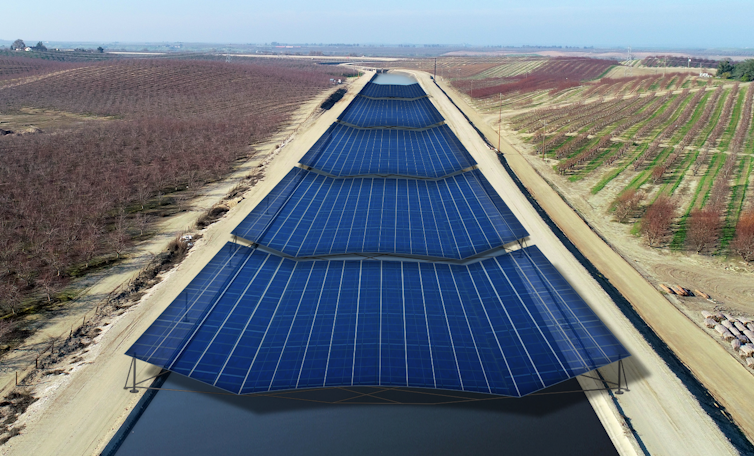
As an engineer, I have been working with colleagues on a way to both protect water supplies and boost renewable energy to protect the climate.
We call it the solar-canal solution, and it’s about to be tested in California.
About 4,000 miles of canals transport water to some 35 million Californians and 5.7 million acres of farmland across the state. As we explained in a 2021 study, covering these canals with solar panels would reduce evaporation of precious water – one of California’s most critical resources – and help meet the state’s renewable energy goals, while also saving money.
The first prototypes in the U.S. for both wide-span and narrow-span canals are now in development in California’s Central Valley. Researchers at the University of California, Merced, are involved in the project, and we will be trying to determine how this can become a large-scale solution.
Conserving water and land
California is prone to drought, and water is a constant concern. Now, the changing climate is bringing hotter, drier weather.
At the same time, California has ambitious conservation goals. The state has a mandate to reduce groundwater pumping while maintaining reliable supplies to farms, cities, wildlife and ecosystems. As part of a broad climate change initiative, in October 2020 Gov. Gavin Newsom directed the California Natural Resources Agency to spearhead efforts to conserve 30% of land and coastal waters by 2030.
Most of California’s rain and snow falls north of Sacramento during the winter, while 80% of its water use occurs in Southern California, mostly in summer. That’s why canals snake across the state – it’s the largest such system in the world. We estimate that about 1%-2% of the water they carry is lost to evaporation under the hot California sun.
In a 2021 study, we showed that covering all 4,000 miles of California’s canals with solar panels would save more than 65 billion gallons of water annually by reducing evaporation. That’s enough to irrigate 50,000 acres of farmland or meet the residential water needs of more than 2 million people. By concentrating solar installations on land that is already being used, instead of building them on undeveloped land, this approach would help California meet its sustainable management goals for both water and land resources.
Climate-friendly power
Shading California’s canals with solar panels would generate substantial amounts of electricity. Our estimates show that it could provide some 13 gigawatts of renewable energy capacity, which is about half of the new sources the state needs to add to meet its clean electricity goals: 60% from carbon-free sources by 2030 and 100% renewable by 2045.
Installing solar panels over the canals makes both systems more efficient. The solar panels would reduce evaporation from the canals, especially during hot California summers. And because water heats up more slowly than land, the canal water flowing beneath the panels could cool them by 10 F, boosting production of electricity by up to 3%.
These canopies could also generate electricity locally in many parts of California, lowering both transmission losses and costs for consumers. Combining solar power with battery storage can help build microgrids in rural areas and underserved communities, making the power system more efficient and resilient. This would mitigate the risk of power losses due to extreme weather, human error and wildfires.
We estimate that the cost to span canals with solar panels will be higher than building ground-mounted systems. But when we added in some of the co-benefits, such as avoided land costs, water savings, aquatic weed mitigation and enhanced PV efficiency, we found that solar canals were a better investment and provided electricity that cost less over the life of the solar installations. And this is before factoring in the human health benefits of improved air quality and reduced greenhouse gas emissions.
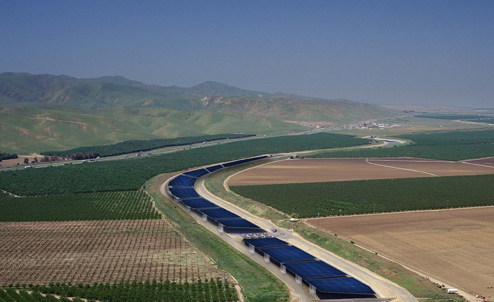
Solar panels installed over canals increase the efficiency of both systems.Brandi McKuin, CC BY-ND
Benefits to the land
To be clear, solar canals are about much more than just generating renewable energy and saving water. Building these long, thin solar arrays could prevent more than 80,000 acres of farmland or natural habitat from being converted for solar farms.
By generating clean electricity, solar canals can improve air quality.
Another benefit is curbing aquatic weeds that choke canals. In India, where developers have been building solar canals since 2014, shade from the panels limits growth of weeds that block drains and restrict water flow.
Fighting these weeds is expensive, and herbicides threaten human health and the environment. For large, 100-foot-wide canals in California, we estimate that shading canals would save about US$40,000 per mile. Statewide, savings could reach $69 million per year.
Artist rendering of a solar canal system for California.Solar Aquagrid LLC, CC BY-ND
Bringing solar canals to California
California’s aging power infrastructure has contributed to catastrophic wildfires and multiday outages. Building smart solar developments on canals and other disturbed land can make power and water infrastructure more resilient while saving water, reducing costs and helping to fight climate change.
[Over 150,000 readers rely on The Conversation’s newsletters to understand the world.Sign up today.]
Turlock Irrigation District, in California’s San Joaquin Valley, will build the first solar canal prototype in partnership with project developer Solar Aquagrid, researchers and others and supported by the state Department of Water Resources.
The prototypes in this mile-long demonstration project, along with future pilots, will help operators, developers and regulators refine designs, assess co-benefits and evaluate how these systems perform. With more data, we can map out strategies for extending solar canals statewide, and potentially across the West.
This is an update of an article originally published on May 3, 2021.
Vanilla flying over sea ice off Alaska’s North Slope in November 2021. Airborne campaigns to the polar regions often fly straight tracks, limited by the need to refuel in between flights. Drones like Vanilla have different needs, and can offer a niche in Earth observations that scientists have traditionally struggled to explore with boots on the ground or instruments already in the air and space. Credits: Platform Aerospace.
They’ve delivered groceries and performed light shows at the Olympics. But in the unforgiving Arctic climate, drones have struggled to fly for extended periods of time — the kind that would allow researchers to fly scientific instruments safely to keep tabs on the region.
Now, a team led by NASA scientists is showing how a fixed-winged drone named Vanilla could fly for several days over the Arctic ocean carrying an instrument that uses radar to measure the depth of snow accumulating on top of sea ice.
By testing the drone and snow radar instrument together, the team wants to provide key data to more accurately track and project how Earth’s polar regions are changing and influencing sea level.
Because snowfall puts an additional layer of snow over sea ice, even some of NASA’s most powerful altimeter systems in space struggle to measure the thickness of the ice. Data from drones flying at low altitudes can help scientists measure this changing thickness more accurately as Arctic sea ice waxes and wanes with the seasons.
“The same technique could eventually be used to assess how freshwater melting from Greenland and Antarctica contributes to sea level rise,” says Brooke Medley, a research scientist at NASA’s Goddard Space Flight Center in Greenbelt, Maryland, who leads the project.
In other words, Medley sees in drones, a path toward increasingly accurate projections of how sea level rise might reshape coastlines worldwide, and, for more temperate climates, a promising new tool to monitor wildfires, algal blooms, and other vital signals of change on Earth.
In November 2021, Vanilla flew for six hours over open ocean and sea ice more than 130 miles (222 km) from an airport in Deadhorse, Alaska, where a pilot controlled the aircraft and a scientist controlled the radar instrument.
By flying in more temperate weather for eight days straight in 2021, Vanilla earned the world record for continuous flight without refueling by a remotely piloted aircraft with internal combustion engine. In Alaska, unusual precipitation prevented multi-day flights, but early assessments show Vanilla could fly for nearly five days over Arctic sea ice.
To earn its “Arctic wings,” Vanilla flew with ice-detecting sensors, heating systems, and a special anti-icing coating to protect against fog and moisture that can quickly ice on its wings and propeller. The aircraft also runs on a diesel engine, which helps to regulate heat unlike battery-operated drones.
“Drones have come a long way, enough that they can start to be more than just quadcopters flying locally and looking at your neighborhood,” Medley says. “Flying drones is ultimately more green and safer than flying large planes, so this checks a lot of boxes.”
Medley, who leads the project, wants to survey sea ice in the Arctic and Southern Ocean with the drone. Ultimately, the idea is to fly over Greenland and Antarctica, Earth’s two ice sheets. Unlike expensive and labor-intensive airborne campaigns that rely on airplanes and crew, multiple drones could fly simultaneously, on a regular basis, and in multi-day surveys of an entire ice sheet, Medley says.
NASA satellites have played a key role in detecting how ice sheets have lost mass in recent decades. But they have struggled to measure fine details about how variations in snow depth on the surface of the ice affect the thickness of these continental glaciers.
Scientists typically determine the health of an ice sheet by measuring changes in surface height that help assess whether the ice is thinning or thickening. But snow blows constantly all around an ice sheet and piles on its surface over several years like a multilayer cake that satellites struggle to track.
“We have to make sure the thickness changes we're seeing aren't just a single snowfall event or the lack of a single snowfall event,” Medley says. “Then we can better interpret the changes that we're seeing from space if we know how much snow is falling.”
Because sea ice is already floating on the ocean, sea level does not rise significantly when that ice melts. But snowfall that settles on the ice sheets eventually melts and deposits freshwater into the ocean. Stored as frozen water on the surface of an ice sheet, this snow can also stall an ice sheet’s contribution to sea level rise, Medley said.
How exactly that accumulated snow influences sea levels is a poorly understood processes in studies of sea level rise.
“We need to monitor this snow accumulation,” Medley said, “because small changes can actually end up playing a very large role in sea level change.”
Roberto Molar Candanosa works for NASA’s Goddard Space Flight Center in Greenbelt, Maryland.
Plastic pollution is accumulating worldwide, on land and in the oceans. According to one widely cited estimate, by 2025, 100 million to 250 million metric tons of plastic waste could enter the ocean each year. Another study commissioned by the World Economic Forum projects that without changes to current practices, there may be more plastic by weight than fish in the ocean by 2050.
On Feb. 28, 2022, a meeting of the United Nations Environment Assembly will open in Nairobi, Kenya. At that meeting, representatives from 193 countries are expected to consider a resolution that would launch negotiations on a legally binding global treaty to reduce plastic pollution. “[N]o country can adequately address the various aspects of this challenge alone,” the draft resolution states.
I believe plastic pollution requires a local, national and global response. While acting together on a world scale will be challenging, lessons from some other environmental treaties suggest features that can improve an agreement’s chances of success.
A pervasive problem
Scientists have discovered plastic in some of the most remote parts of the globe, from polar ice to Texas-sized gyres in the middle of the ocean. Plastic can enter the environment from a myriad of sources, ranging from laundry wastewater to illegal dumping, waste incineration and accidental spills.
Plastic never completely degrades. Instead, it breaks down into tiny particles and fibers that are easily ingested by fish, birds and land animals. Larger plastic pieces can transport invasive species and accumulate in freshwater and coastal environments, altering ecosystem functions.
A 2021 report by the National Academies of Sciences, Engineering and Medicine on ocean plastic pollution concluded that “[w]ithout modifications to current practices … plastics will continue to accumulate in the environment, particularly the ocean, with adverse consequences for ecosystems and society.”
To address this problem, the U.S. has focused on waste management and recycling rather than regulating plastic producers and businesses that use plastic in their products. Failing to address the sources means that policies have limited impact. That’s especially true since the U.S. generates 37.5 million tons of plastic yearly, but only recycles about 9% of it.
In my view, however, these efforts too will fall short if countries producing and using the most plastic do not adopt policies across its life cycle.
Growing consensus
Plastic pollution crosses boundaries, so countries need to work together to curb it. But existing treaties such as the 1989 Basel Convention, which governs international shipment of hazardous wastes, and the 1982 U.N. Convention on the Law of the Sea offer little leverage, for several reasons.
First, these treaties were not designed specifically to address plastic. Second, the largest plastic polluters – notably, the U.S. – have not joined these agreements. Alternative international approaches such as the Ocean Plastics Charter, which encourages governments and global and regional businesses to design plastic products for reuse and recycling, are voluntary and nonbinding.
Fortunately, many world and business leaders now support a uniform, standardized and coordinated global approach to managing and eliminating plastic waste in the form of a treaty.
The American Chemistry Council, an industry trade group, supports an agreement that will accelerate a transition to a more circular economy that promotes waste reduction and reuse by focusing on waste collection, product design and recycling technology. America’s Plastic Makers and the International Council of Chemical Associations have also made public statements supporting a global agreement to establish “a targeted goal to ensure access to proper waste management and eliminate leakage of plastic into the ocean.”
However, these organizations maintain that plastic products can help reduce energy use and greenhouse gas emissions – for example, by enabling automakers to build lighter cars – and are likely to oppose an agreement that limits plastic production. As I see it, this makes leadership and action by governments critical.
The Biden administration also has stated its support for a treaty and is sending Secretary of State Antony Blinken to the Nairobi meeting. On Feb. 11, 2022, the White House released a joint statement with France that expressed support for negotiating “a global agreement to address the full life cycle of plastics and promote a circular economy.”
Early treaty drafts outline two competing approaches. One seeks to reduce plastic throughout its life cycle, from production to disposal, a strategy that would probably include methods such as banning or phasing out single-use plastic products.
A contrasting approach focuses on eliminating plastic waste through innovation and design – for example, by spending more on waste collection, recycling and development of environmentally benign plastics.
Some harmful impacts of plastic waste become more intense as the plastic breaks down into smaller and smaller fragments.
Elements of an effective treaty
Countries have come together to solve environmental problems before. The global community has successfully addressed acid rain, stratospheric ozone depletion and mercury contamination through international treaties. These agreements, which include the U.S., offer strategies for a plastics treaty.
The Montreal Protocol, for example, required countries to report their production and consumption of ozone-depleting substances so that countries could hold each other accountable. As part of the Convention on Long-range Air Pollution, countries agreed to reduce sulfur dioxide emissions, but were allowed to select the method that worked best for them. For the U.S., that involved a system of buying and selling emission allowances that became part of the Clean Air Act Amendments of 1990.
Based on these precedents, I see plastic as a good candidate for an international treaty. Like ozone, sulfur and mercury, plastic comes from specific, identifiable human activities that occur across the globe. Many countries contribute, so the problem is transboundary in nature.
In addition to providing a framework for keeping plastic out of the ocean, I believe a plastic pollution treaty should include reduction targets for both producing less plastic and generating less waste that are specific, measurable and achievable. The treaty should be binding but flexible, allowing countries to meet these targets as they choose.
In my view, negotiations should consider the interests of those who experience the disproportionate impacts of plastic, as well as those who make a living off recycling waste as part of the informal economy. Finally, an international treaty should promote collaboration and sharing of data, resources and best practices.
Since plastic pollution doesn’t stay in one place, all nations will benefit from finding ways to curb it.
[Over 140,000 readers rely on The Conversation’s newsletters to understand the world.Sign up today.]
Clear Lake when the water color is more blue than green. The water is relatively clear during spring allowing the red and yellow lights to be absorbed deep throughout the water column, reflecting and scattering back vibrant blues. Photo Credit: Angela De Palma-Dow. Dear Lady of the Lake,
The lake water over by Lucerne to Glenhaven looks brown, is this a spill or leak from something? What’s going on with the lake right now?
Thanks!
- Water that’s brown has got me down Walter
Hello Walter,
Thanks for the question! This is a common observation this time of year, and I am glad you provided the opportunity for me to discuss this in my column.
The first question to ask when trying to “diagnose” a lake situation, when it comes to water issues, is to identify the scope and size of the specific situation. In this case, the area you describe is pretty large - according to my trusty Google My Maps measuring feature, the open water area along the shoreline between Glenhaven and Lucerne is about seven (7) miles. That is really a long distance and includes a large expanse of water. The area around the Narrows is fast moving water, as the current from the Upper Arm into the Lower and Oaks Arm is quite significant, even on non-windy days.
Based on the size of the area and the type of water movement, I would immediately eliminate the possibility of there being a spill or leak in the area causing this brown coloration. The area impacted is just too vast for any type of spill or leak. I also checked with the California Governor’s office of Emergency Services (Cal OES) online HazMat Spill Release Reporting Database <https://w3.calema.ca.gov/operational/malhaz.nsf/$defaultview> , and there have not been any reports of spills or leaks in that area and of that magnitude.
In addition, spills in areas with rough water or water with current tend to dilute and break up quickly over time. So if you are observing continuous brown coloration between the Upper Arm and through the Narrows to Glenhaven, then this most definitely is not a spill, but something within the water column itself.
Back to the Beautiful Basics: Colors of Light and Lakes
There are several possibilities that influence the color of lake water. Before we dive into what causes the browning of water or the lake, we need to remember the basics about how we see colors and what physical processes in water determine the colors that we can see.
Think about a time in winter or spring, when you have looked at Clear Lake from a hill or mountain. When looking at the lake from afar, the water color we see is what is most of the time the color light wavelengths that are scattered back, or refracted, from penetrating the water column.
According to the WebExhibits interactive Museum of Science, Humanities, and Culture, Causes of Color Series: "Visible light is merely a small part of the full electromagnetic spectrum… humans can detect the range of light spectrum from about 400 nanometers (violet) to about 700 nanometers (red). Humans perceive this range of light wavelengths as a smoothly varying rainbow of colors, otherwise known as the visual spectrum.”
This means that blue and green wavelengths are shorter than red, yellow and orange wavelengths. The longer wavelengths (lower energy) are being absorbed in the water column, and the shorter wavelengths (higher energy) are scattering or refracting back. Hence, when we look at deep, clear water lakes, such as Lake Tahoe, we see those lakes as very vibrant blue, because all the other colors are being absorbed except for the blues.
When we look at a blue lake, if we went down to the shore, and scooped up a cup of that lake water, it would appear very clear, and not blue at all. That’s important to note, because the depth of a lake can influence the blue color we see too. Deeper lakes can appear a darker blue, more frequently, while shallower lakes, while still appearing blue, are more bright blue more often then darker blue or other colors. The deeper the lake, the longer the space available for red, yellow, and orange wavelengths to become absorbed and for the blues to reflect, refract, and scatter back to be visible by our eyes.
Some very shallow lakes, or portions of lakes, like the Upper Arm in Clear Lake, do appear blue on occasion, usually when the lake is in its most clear water state, such as winter and early spring. Some times during the year, materials in the water can cause the blue light to become absorbed and other colors to reflect.
Browning lakes
Materials in the water column can influence the color of a lake. There are several scenarios where this is the case, but for today we are going to focus on the scenarios that will cause a lake or lake water to look brown.
Note that this discussion will focus on Clear Lake specifically, and may not apply to other lakes. For example, lakes in the Northeastern US are going through a “browning” phase, which visually looks alarming, especially to those who grew up with blue, clear lakes in the Northeast, the browning is actually a sign of potential lake recovery since the reduction of acidic rain deposition between 1990 and the 2020s.
The passage of the 1990 Clean Air Act, which mandated reductions in nitrogen and sulfur containing compounds from industry, and increase of precipitation in a heavily forested region, is responsible for helping lakes in the Northeast regain their brownness. It’s a fascinating story, one which you can learn more here in this publicly accessible special Issue from the North American Lake Management Society Magazine, Lake Line “Lake Management in a Browning World: Beyond the Holy Grail of Nutrients” by C.E. Williamson (2020). Particles in the water column
Okay, well back to our neck of the woods: Clear Lake! Walter had mentioned that areas off shore of Lucerne down to the narrows, looked brown. This observation occurred recently, within the month of February. For this time of year, there can be several explanations.
First, the brown water could be literally just stirred up brown sediments or clay floating around in the water column. These materials can be either dissolved (less than 22 micrometers in size) or particulate particles (greater than 22 micrometers and easily able to be filtered out) in the water column.
The Upper Arm of Clear Lake is relatively shallow; when the lake is at the high water mark, or 7 ft Rumsey, the deepest point of the Upper Arm is roughly between 7-8 meters or 22-26 feet deep. But the majority of the Upper Arm is much shallower than this, meaning that a large wind event that last several days can easily stir up the mud, muck, and silt on the bottom of the lake and mix it into the water column, which when dissolved, can take several days to weeks to filter out and settle to the bottom.
We all know that January through April can bring some very windy conditions out on the lake, with white caps and waves dashing any relaxing ideas of paddle boarding, canoeing, or kayaking. Just imaging the impact of that wave energy on the loose sediment layer laying at the bottom of the lake, it’s easy to see how the brown water can just be remnants of sediment and water mixing from windy conditions.
Back to light wavelengths. Particles in the water column can both absorb and reflect different light wavelengths. Sometimes there is so much material in the water column that light is being absorbed immediately and can’t penetrate through the water column, meaning that none of the blue light can be reflected or scattered back, since it too, is being absorbed.
Carbon sources in lakes
Second, the brown water we see in parts of the Lake can be reflections of carbon materials in the water column. Carbon is the building block of everything living, our bodies are made of carbon through the food we eat, trees and plants take in CO2 from the atmosphere and convert the carbon gas into carbon structure, and organisms in the lake use carbon for similar purposes. Sources of carbon found in a lake can come from two sources, external or internal. External sources of carbon can be anything that is carbon-based that flows or falls into the lake from the terrestrial landscape.
Leaves falling off a tree into a river that flows down into the lake is a perfect example of an external source of carbon. The leaves are broken down into smaller carbon building blocks, first in the river then once they flow downstream, in the lake. The leaves also contain lots of other nutrients such as nitrogen.
Internal sources of carbon include those that are already located within the lake, such as algae, dead aquatic critters, and aquatic plants, to name a few. Submersed aquatic plants are ones that grow entirely under the water surface. They use carbon to create their growing, branching structure, then in the fall and winter when they die and decompose, the carbon is released back into the water column and sediments.
Like sediments and clays, carbon can be particulate and dissolved. Dissolved carbon can influence lake water color. For example, externally sourced carbon, from heavy non-deciduous forested areas, can be brown or red in color. You might have heard of this coloration called tannins. It’s similar to tea, with the tea leaves or tea bags being the external carbon source (like leaves or pine needles) that is leaching dissolved carbon into the water and changing the color to brown or reddish.
In lakes with high dissolved organic carbon matter, they can appear brown or almost reddish. This is because the dissolved particles in the water column are really good at absorbing the shorter blue and green wavelengths and not as good at absorbing the longer red wavelengths. So these high tannin and carbon lakes can look red, brown, or even sometimes black, since the colors being scattered back to our eyes are at the low energy red end of the light spectrum.
Generally, areas covered in coniferous trees (pines, redwoods, firs, cedars etc.) will have lakes or streams with more tannins and more dark brown/red waters. Areas surrounded by agriculture or deciduous trees (oaks and madrones) will tend to have less tannins and less brown waters.
Now in general, there is not enough forested area in the Clear Lake watershed to turn all of clear lake brown, and especially this year there was not enough precipitation to wash all the downed coniferous tree materials into the lake. In years when there is enough precipitation to have large runoff events, there is lots of precipitation from non-coniferous areas, so it balances out that in general, tannins are not a huge coloration factor on Clear Lake water color.
Diatoms are much smaller, and sometimes more brown in color, then green algaes. This microscopic photo shows free-floating or planktonic diatom genus Stephanodiscus with the filamentous green alga, Spirogyra near the top left of the photo (hair algae). Image Credit: Lauren Fuelling, Image Source: diatoms.org. Diatoms
Third, watercolor can be influenced by the very small phytoplankton (green algae) and cyanobacteria that grow in the lake and feed off the carbon and nutrients provided by the internal and external sources of nutrients like nitrogen and phosphorus. Some of these phytoplankton are more dominant and abundant at certain times of the year, and recognizing patterns in these seasonal dynamics can help us determine what we are seeing out in the water, particularly if it’s brown in color.
Winter and early spring, lakes usually see increases in populations of diatoms. Diatoms are probably some of the coolest and unique types of phytoplankton, or algae, found in freshwaters across the world.
According to the amazing reference online of Diatoms of North America (diatoms.org) diatoms “are algae that live in houses made of glass. They are the only organism on the planet with cell walls composed of transparent, opaline silica. Diatom cell walls are ornamented by intricate and striking patterns of silica.” Diatoms are very unique, but they have evolved to coincide in lakes with increased green algae and cyanobacteria bloom periods in the warmer periods of spring and summer.
Diatoms tend to be the most abundant in north american freshwater lakes in late fall through winter and into early spring, when the water is still relatively cold and there is limited sunshine. This time of year the growth of green algae and cyanobacteria is relatively low, and the lake water is relatively clear, leaving the diatoms the most ideal conditions to take advantage of the available sunlight and reproduce in abundance.
Diatoms, due to their glass structure, are prone to sinking and do well in times of water turbulence from wind events and lake mixing. As we discussed earlier, Clear Lake in the winter and spring is prone to mixing from wind events during the early parts of the year, so in addition to seeing brown sediments in the water in February, you might also be spying some diatom blooms.
The seasonal dynamics of diatoms, green algae and cyanobacteria is worth considering as climate change and a warming planet continue to disrupt “normal” temperature and storm cycles, in Clear Lake and other freshwaters across the globe. As the summer season expands, allowing longer periods of warm weather to dominate, the suitable range for diatoms will grow shorter, and it’s unclear if they can co-evolve fast enough to meet the challenge.
Boat side view of a very happy brown Gloeotrichia bloom in June 2019 in the Konocti Bay region of the Lower Arm. Billions of tiny brown gloeotrichia cells are rapidly reproducing and create large expanses of brown water within Clear Lake. If you scooped some of the brown water into a clear glass, you could see the individual spiked cells floating around. Photo credit: Angela De Palma-Dow. Some cyanobacteria can be brown too
Lastly, blooms of the cyanobacteria Gloeotrichia can cause brown looking water when blooming in the lake. However, Gloeotrichia can also be shades of green, but unlike some of the other cyanobacterias, more strains of Gloeotrichia have brownish hues. If you have been out on the lake over the last two summers (2020-2021) gloeotrichia has been responsible for making some large brown stripes throughout the center of the Upper Arm and Lower Arm in summer and fall.
The brown water observed this last February (2022) could very well have been a bloom of Gloeotrichia, especially since recently we have had some spring-like warm weather, but it’s more likely to see these brown bloom events in the warm and sunny summertime in Clear Lake.
Gloeotrichia, although a cyanobacteria, has so far in Clear Lake not been observed to produce toxins like Microcystis, the most common toxin-producing genus of cyanobacteria in Clear Lake. That doesn’t mean that it won’t sometimes in the future, but until now that has not been observed and it’s only offense has been the occasional brown bloom in the middle of the lake during prime water-skiing weather.
Both diatoms and gloeotrichia are still considered particles that float in the water, and they absorb blues and green light wavelengths and reflect red and orange wavelengths, that’s why when you see these particles floating around in the lake they appear brown and when they are very abundance, large areas of water can appear very brown and almost reddish at times.
Gloeotrichia sp. is a type of cyanobacteria collected and photographed under microscope by Big Valley Rancheria Cyanobacteria Monitoring Program. Oaks Arm 2020. Photo credit: Sarah Ryan. Image source: Clear Lake Water Quality Facebook Page (@ClearLakeWaterQuality) So why is the water brown now?
In summary Walter, based on the large expanse of brown water, given the time of year and the weather conditions we have been experiencing, my best guess as a lake biologist is that you are witnessing some sediment material turbidity from the recent wind events. To further substantiate my claim, I would argue that when we do get winds, they tend to normally (although, not always, I admit) come from the North or North West and blow east, towards the shores of Lucerne and the Narrows.
Further, this leads me to believe that during these westerly winds, the lake sediments and silts on the bottom of the shallow Upper Arm were stirred up, pushed towards that part of the lake, and the dissolved particles contained within that moved water, were floating around in the water column on the eastern shores of the lake.
I would also not be surprised that if we took some samples of water from those locations, and looked under the microscope at some slides, we might find the water rich and abundant with diatoms, which can greatly contribute some brown hues to the water. January and February are indeed diatoms' preferred time of year and they like being suspended in water that has been stirred up by wind and waves.
However, as the growing season marches along and the air and water temperature increases and the sunlight periods lengthen, if you are still seeing brown water, my diagnosis will of course, change. As many things in life, lakes are always variable and hardly consistent, but they are always consistently variable.
Sincerely,
Lady of the Lake
In addition to those linked within the article, some valuable resources used in this column include:
Angela De Palma-Dow is a limnologist (limnology = study of fresh inland waters) who lives and works in Lake County. Born in Northern California, she has a Master of Science from Michigan State University. She is a Certified Lake Manager from the North American Lake Management Society, or NALMS, and she is the current president/chair of the California chapter of the Society for Freshwater Science. She can be reached at This email address is being protected from spambots. You need JavaScript enabled to view it..
LAKE COUNTY, Calif. — The federal government has rejected a wind energy project that would have installed dozens of giant turbines in the Walker Ridge area.
On Friday, the Bureau of Land Management said it has denied the application for the Walker Ridge Wind Energy Project.
The agency said the denial was based on potential resource conflicts and the inadequacy of the information provided to the BLM to address these conflicts and to move forward with the environmental review.
“Given the application denial, the BLM will not be preparing an environmental impact statement or potential land use amendment for this project,” the agency said in the Friday announcement.
Bob Schneider, a member of the Protect Walker Ridge Alliance and an author who has written a book about the Berryessa Snow Mountain National Monument, has lobbied against the project for years.
“I am so pleased that the Bureau of Land Management has denied Colusa LLC and Algonquin a wind development permit,” he said in an email to Lake County News. “With passage of Congressman John Garamendi’s Berryessa Snow Mountain National Monument Expansion Act (H.R. 6366) this threat of industrial scale development on Condor Ridge will be gone. The wind is marginal and the environmental and social costs are large.”
Colusa Wind LLC proposed the Type III wind energy project in June 2018.
Colusa Wind, a company that state corporation records showed had a San Diego address, was reported to be managed by Liberty Power, which was owned by Canada-based Algonquin, a company on both the New York and Toronto stock exchanges.
The project would have included up to 42 wind turbines generating 144 megawatts on approximately 2,272 acres of BLM-managed public land along Walker Ridge, within the Indian Valley Management Area in Lake and Colusa counties.
The project raised many concerns for the safety of wildlife, the impact on the environment — including soil moving and traffic in an area known for serpentine soils — and the impact of dozens of windmills that would have measured up to 676 feet tall and been visible for miles across Lake County and into neighboring counties.
By the spring of 2020, the BLM told Lake County News that its process to review the project had stopped. At that time, it needed wind surveys and data before it could move forward with consideration, including releasing a public review of the draft project and listing a reasonable management alternative.
Then, in July, Congressman John Garamendi, who represents a portion of Lake County that includes the Walker Ridge area, released a discussion draft of the Berryessa Snow Mountain National Monument Expansion Act, which proposes to add the 4,000-acre Walker Ridge tract to the monument.
The act also changes the name of the entire ridgeline in Lake and Colusa counties from “Walker Ridge” to “Condor Ridge — which means “Molok Luyuk” in the Patwin language.
Then, the BLM announced its decision this week.
“Molok Luyuk or Condor Ridge, also known as Walker Ridge is a special and spiritual place that tells a story of plate tectonics, diversity of plants and animals, Native American habitation over thousands of years,” said Schneider.
Schneider said the area’s ridge road is accessible and from the ridge one can see from Mount Diablo to Mount Shasta and from the Sierra crest to Mount Konocti.
“I hope that we can plan and build a small accessible site with a boardwalk, platform, and interpretive kiosk in order that all might know and enjoy this place,” Schneider said.
This was not the first wind energy project in the Walker Ridge area, but it is expected to be the last if the expansion bill becomes law.
In 2010, AltaGas Income Trust, based in Calgary, Alberta, submitted a proposal to the BLM for a 60- to 70-megawatt clean energy wind generation project with 29 turbines to be located within a 8,157-acre area leased by the BLM to the company.
The review process for that project — which the BLM said was in a slightly different area that Colusa Wind’s project — came to an end in 2013.
Schneider said there is still a possibility that Colusa Wind could appeal the BLM’s decision, adding he hopes they won’t.
Email Elizabeth Larson at This email address is being protected from spambots. You need JavaScript enabled to view it.. Follow her on Twitter, @ERLarson, or Lake County News, @LakeCoNews.
A spectacular head-on collision between two galaxies fueled the unusual triangular-shaped star-birthing frenzy, as captured in a new image from NASA’s Hubble Space Telescope.
The interacting galaxy duo is collectively called Arp 143. The pair contains the glittery, distorted, star-forming spiral galaxy NGC 2445 at right, along with its less flashy companion, NGC 2444 at left.
Astronomers suggest that the galaxies passed through each other, igniting the uniquely shaped star-formation firestorm in NGC 2445, where thousands of stars are bursting to life on the right-hand side of the image.
This galaxy is awash in starbirth because it is rich in gas, the fuel that makes stars. However, it hasn’t yet escaped the gravitational clutches of its partner NGC 2444, shown on the left side of the image. The pair is waging a cosmic tug-of-war, which NGC 2444 appears to be winning. The galaxy has pulled gas from NGC 2445, forming the oddball triangle of newly minted stars.
“Simulations show that head-on collisions between two galaxies is one way of making rings of new stars,” said astronomer Julianne Dalcanton of the Flatiron Institute’s Center for Computational Astrophysics in New York and the University of Washington in Seattle.
“Therefore, rings of star formation are not uncommon. However, what’s weird about this system is that it’s a triangle of star formation. Part of the reason for that shape is that these galaxies are still so close to each other and NGC 2444 is still holding on to the other galaxy gravitationally. NGC 2444 may also have an invisible hot halo of gas that could help to pull NGC 2445’s gas away from its nucleus. So they’re not completely free of each other yet, and their unusual interaction is distorting the ring into this triangle,” said Dalcanton.
NGC 2444 is also responsible for yanking taffy-like strands of gas from its partner, stoking the streamers of young, blue stars that appear to form a bridge between the two galaxies.
These streamers are among the first in what appears to be a wave of star formation that started on NGC 2445’s outskirts and continued inward. Researchers estimate the streamer stars were born between about 50 million and 100 million years ago. But these infant stars are being left behind as NGC 2445 continues to pull slowly away from NGC 2444.
Stars no older than 1 million to 2 million years are forming closer to the center of NGC 2445. Hubble’s keen sharpness reveals some individual stars. They are the brightest and most massive in the galaxy. Most of the brilliant blue clumps are groupings of stars. The pink blobs are giant, young, star clusters still enshrouded in dust and gas.
Although most of the action is happening in NGC 2445, it doesn’t mean the other half of the interacting pair has escaped unscathed. The gravitational tussle has stretched NGC 2444 into an odd shape. The galaxy contains old stars and no new starbirth because it lost its gas long ago, well before this galactic encounter.
“This is a nearby example of the kinds of interactions that happened long ago. It’s a fantastic sandbox to understand star formation and interacting galaxies,” said Elena Sabbi of the Space Telescope Science Institute in Baltimore, Maryland.
The Hubble Space Telescope is a project of international cooperation between NASA and ESA (European Space Agency). NASA’s Goddard Space Flight Center in Greenbelt, Maryland, manages the telescope. The Space Telescope Science Institute (STScI) in Baltimore, Maryland, conducts Hubble science operations. STScI is operated for NASA by the Association of Universities for Research in Astronomy in Washington, D.C.
Donna Weaver works for the Space Telescope Science Institute.
California’s child care crisis dates back decades, but COVID-19 has taken a deep toll. A new UC Berkeley report says the system has chronically relied “on paying poverty and near-poverty-level wages.” Credit: Ana Fox-Hodess | UC Berkeley. BERKELEY — California’s child care providers and teachers are earning such low wages that many need government assistance to make ends meet, and conditions are so dire that “radical reform” is needed to support them and to stabilize the entire child care system, says a new UC Berkeley study.
Among nearly 8,000 child care staff surveyed in 2020, median wages are below or near federal poverty levels, says the report from Berkeley’s Center for the Study of Child Care Employment (CCSCE). About a third reported that they are enrolled in Medi-Cal or other forms of public assistance, and a like percentage reported basic food insecurity.
The new study found that early educators — mostly women of color and immigrant women — struggle in “a grim financial bind” because of California’s low public investment in the child care system.
This financial stress has been compounded by the COVID-19 pandemic, which has made the low wages educators depend on even more unreliable. The stress is reflected in a shortage of child care services for working families, and that creates risks for the California economy, said CSCCE Director Lea Austin. There are at least 1 million children on the waiting list for subsidized child care.
“We need long-term solutions to ensure early educators’ economic well-being,” Austin said in an interview. “Without that, parents are going to keep having trouble finding the quality child care they need.”
“The economy can’t work without child care,” Austin added. “And child care can’t work without teachers.”
One early childhood educator quoted in the report is an immigrant with a bachelor’s degree from her home country in Asia and extensive training in early childhood education. But even after five years working at a center in California, she still earns only $15 per hour — a little more than $30,000 a year, before taxes.
“This profession surely requires education to give better quality care, but it seems like it is not being respected enough, in terms of salary,” she told the Berkeley researchers. “Even if I work full time, 40 hours a week, my annual salary is still below poverty level.”
"‘The Forgotten Ones’ — The Economic Well-Being of Early Educators During COVID-19” is based on the largest study in 15 years of California child care business owners and teachers. It offers troubling insight into conditions that affect nearly 140,000 child care providers, teachers and administrators working at California’s child care centers and care programs based in family homes.
The new report was researched and written by Austin; CSCCE analysts Anna Powell, Elena Montoya, Yoonjeon Kim and Abby Copeman Petig; and consultant Raúl Chávez.
It underscores the dire conclusions that emerged nearly two years ago in a separate CSCCE report on how COVID-19 had forced hundreds of California child care centers to close and put countless others at risk.
Median wages are below or near federal poverty levels, says the new UC Berkeley report. About a third of surveyed child care professionals reported that they are enrolled in Medi-Cal or other public assistance. A similar percentage said they’re suffering from food insecurity. Credit: Ana Fox-Hodess/UC Berkeley. A child care system based on poverty-level wages
Today’s crisis dates back decades, but according to the new report, one condition has been constant: California’s child care system “relies on paying poverty and near-poverty-level wages.”
The impact on child care workers — and on child care homes and centers — is stark.
• The median wage for a California child care worker in 2019 was $13.43 per hour, while preschool teachers earned $16.83 per hour. By comparison, however, a kindergarten teacher earned $41.86 per hour — and even that was just above the California living wage for a single parent with one child.
• In the first year of the pandemic, more than 40% of family child care providers and nearly a third of center-based teachers were enrolled in public assistance programs, such as Medi-Cal or food support.
• Roughly one-third of early childhood teachers experienced food insecurity, with either not enough food to eat, or not enough quality or nutritional food. For women of color, the prevalence of food insecurity rose to 39%, and to 42% for immigrant educators.
• Almost one in three family child care providers in the early months of the pandemic were behind on rent or mortgage payments for the homes where they provide care.
The pandemic dramatically compounded the stresses on early care and education professionals in other ways, too, the report found. Some providers shut down their operations, temporarily or permanently. Workers were laid off and furloughed. Forty percent of family care providers and a third of center teachers in the state applied for unemployment after the pandemic hit in 2020.
As staffs were reduced, some educators had to put in longer hours. Meanwhile, 43% of those who operate child care centers from their homes said they were unable to pay themselves salaries for periods in 2020.
Black educators were far more likely to experience such negative business consequences, the report found.
“It's no wonder that programs are understaffed, and many have closed, which means families can't find the child care they need,” Austin said. “There was already a shortage before the pandemic, and the people who remain are under incredible financial, emotional and physical stress.”
The threat of COVID-19 forced numerous early child care centers to limit operations or close. That meant reduced hours for staff members who were already struggling financially and made care more scarce for families. Credit: Brittany Hosea-Small/UC Berkeley. The importance of long-term public funding for child care
According to the study, however, centers with federal Head Start or California State Preschool funding were more sheltered from COVID’s negative impact. Policymakers in Washington, D.C., and Sacramento implemented measures to shield the centers from dramatic income loss. And, the researchers found, 90% of administrators and staff at those centers had no problem paying the program’s rent or themselves and did not have to take on debt to cover costs.
That, the authors said, points to the “radical reforms” that could address economic disparities between different types of providers and between those who do and do not have public funding.
One priority for policymakers, they wrote, should be to establish contract-based models with state and federal funding for both centers and home-based providers. This is similar to how Head Start and state preschool funds are currently distributed.
They urged policymakers to set a minimum wage for California’s early educators, based on regional costs of living and by taking into account workers’ education and experience. An ideal target would be parity with kindergarten and elementary school teachers, they said. The CSCCE has found that among the state’s early childhood educators, the majority have college degrees.
Policymakers should also develop solutions to end inequality that harms women of color and immigrants in the early child care and education field.
Without such solutions, the Berkeley report warned, the pandemic’s damage to California’s child care system could be permanent. Some care facilities that closed during the pandemic may never reopen, and younger child care professionals may leave the field for work that pays a living wage.
“We can’t fault people for leaving for jobs with better pay and health insurance and not coming back to child care,” Austin said. “We can’t get to good, stable child care if we can’t stabilize and support the early care and education workforce. Until we intervene with public resources, the problem will not go away.”
With hopes cautiously rising that the pandemic will ease, “I just want to work and recover my life, little by little,” said one care provider who was interviewed for the report. “If there were support for us providers, even loans, so I could pay the mortgage and keep my house, that would be great.
“I don’t want to have to close and look for another job, because I really like working with children.”
Edward Lempinen writes for the UC Berkeley News Center.
Continuing the state’s phased rollback of executive orders implemented in response to the pandemic, Gov. Gavin Newsom on Friday took action to lift all but 5% of COVID-19 related executive order provisions, while maintaining critical measures that support the state’s ongoing response and recovery efforts.
The remaining provisions include maintaining California’s nation-leading testing and vaccination programs and protecting hospital and health facility capacity, key components of the state’s SMARTER Plan to guide California’s evolving pandemic response with a focus on continued readiness, awareness and flexibility.
“California’s early and decisive measures to combat COVID-19 have saved countless lives throughout the pandemic, and as the recent Omicron surge made clear, we must remain prepared to quickly and effectively respond to changing conditions in real time,” said Gov. Newsom. “As we move the state’s recovery forward, we’ll continue to focus on scaling back provisions while maintaining essential testing, vaccination and health care system supports that ensure California has the needed tools and flexibility to strategically adapt our response for what lies ahead.”
Before Friday’s action, only 15% of COVID executive actions remained in effect, in keeping with the process the governor established in June 2021 to scale back provisions as they cease to be necessary.
Under the order signed by the governor on Friday, 19 of the remaining provisions are terminated immediately, with an additional 18 to be lifted on March 31 and 15 to expire on June 30 to ensure that impacted individuals and entities have time to prepare for the changes.
As part of the state’s SMARTER Plan, the governor will continue this focus on lifting additional provisions as they are no longer needed for the ongoing pandemic response.
“California’s health care delivery system remains deeply strained because of the pandemic,” Carmela Coyle, president and CEO of the California Hospital Association, said Friday. “Hospital capacity is still stretched beyond normal as people who delayed needed care are now being seen and 20% of health care workers have left the field. Today's extension of certain key, temporary flexibilities means that hospitals can continue to use things like tents to receive and triage patients and retain out-of-state health care personnel to maximize care capacity throughout the state."
Seventeen of the executive actions still in effect remain critical to bolstering the state’s COVID-19 testing and vaccination programs and preventing potential strain on the health care delivery system, including:
• COVID testing: Four provisions provide flexibility critical to support the state’s testing program, which under the SMARTER Plan will need to continue being able to process at least 500,000 tests per day. For example, through executive action the governor has waived a provision that would require a health care professional to review each test result before it was released electronically to patients, and expanded scopes of practice for pharmacists and pharmacy technicians to conduct COVID tests.
• Vaccinations and boosters: Two provisions provide critical flexibility to support the state’s vaccination and booster programs, which under the SMARTER Plan will need to continue being able to distribute at least 200,000 doses per day. This includes waiving licensing requirements temporarily to enable pharmacists and pharmacy technicians to administer COVID vaccines and waiving requirements so that the state can offer mobile vaccine clinics.
• Protecting hospital capacity and vulnerable populations: There are 11 provisions that are necessary to protect both capacity in our health care delivery system and vulnerable populations, particularly during COVID surges. This includes provisions allowing health care workers from out of state to provide services in California and enabling the Department of Developmental Services to provide remote and expanded nonresidential services for more clients.
“Telehealth services have been an important component of care during the pandemic, enabling patient access to safe nonemergency medical appointments,” said California Medical Association President Robert E. Wailes, M.D. “Extending the executive order ensures patients can continue to access expedited health care services by aligning California and federal telehealth policy while we continue to navigate.”
The other 13 remaining provisions ensure COVID workplace safety standards remain aligned with the most current public health guidance and evidence, and provide important flexibility to state and local agencies to administer the emergency response while the state of emergency remains open.
“Skilled nursing facilities in California are in the midst of the worst workforce shortage in their history,” said California Association of Health Facilities President and CEO Craig Corbett. “The governor’s actions today to continue some flexibilities should help the sector continue to provide quality care to patients and residents.”
Newsom also signed a proclamation terminating 12 open states of emergency related to various fires, heat waves and other incidents dating back to 2015.
Last week Newsom unveiled the SMARTER Plan, which outlines the state’s strategic approach to managing the next phase of the pandemic with core pillars and preparedness metrics based on proven strategies used to successfully slow the spread of the virus and protect Californians.
Last year’s budget appropriated $1.7 billion to combat COVID-19 in fiscal year 2021-22. Now, Gov. Newsom’s $3.2 billion COVID-19 Emergency Response Package, including $1.9 billion in early action funding that has already been approved, will help bolster the state’s ongoing vaccination and testing efforts, support workers, strengthen the health care system and combat misinformation.
LAKE COUNTY, Calif. — On Thursday, the Lake County Planning Commission denied a permit application for a large cannabis operation that would have been located next to Hidden Valley Lake, a move taken at the recommendation of county staff.
Zarina Otchkova’s We Grow LLC’s project proposed a nine-acre grow, processing and distribution operation on a 309-acre property located at 16750 Herrington Road, 17610 Sandy Road and 19678 Stinson Road in Middletown.
The proposal included 34 greenhouses, four drying buildings, a shed, 20 water tanks and privacy fencing.
The previous version of the project was approved by the commission in April of last year but concerned neighbors appealed that decision within the prescribed seven-day appeal period.
In June 2021, the Board of Supervisors heard the appeal and upheld it, citing a faulty environmental document.
However, the board’s vote for the appeal was done without prejudice, allowing the project to be resubmitted, which it was later last year.
On Thursday, Community Development Department staff told the commission that they were recommending denying the project, which the applicant’s attorney and consultant indicated was an abrupt change that caught them off guard when they found out about it earlier this month.
Associate Planner Eric Porter said planning staff put the project through another evaluation under the California Environmental Quality Act, or CEQA.
Porter said CEQA is fairly specific in terms of when a project rises to the level of “significant”and requires an environmental impact report, or EIR. A “significant” finding is whenever there are impacts that cannot be adequately mitigated, he said.
In this case, one of the key issues was the proposed removal of 130 mature blue oak trees, which would have to be replaced at a three-to-one ratio, with the tree restoration to take place over a period of up to 40 years.
Porter questioned if those trees’ removal could be mitigated, concluding that it’s unknown but “highly unlikely,” and that the project’s tree removal and replacement plan was not sufficient.
Porter said the tree removal goes beyond the trees itself, and affects the earth, results in erosion and has water impacts which haven’t been evaluated for the difference in demand between mature trees and saplings. He added that the water issue is an unknown.
Commissioner John Hess said it would be years before replacement trees are mature and able to provide what the original trees do. Porter said that’s what concerned groups like the Redbud Audubon Society.
“You’re right. The impacts are pretty obvious and pretty significant,” Porter said to Hess.
He also referred to extensive public comment against the project, with the county receiving close to 150 such comments. Recurring themes in those comments included traffic, security, safety, conflicting land use, water, habitat and odor, among others.
Porter added that an appeal, no matter what decision the commission made, was likely.
Due to the unmitigated impacts, Porter said staff recommended denying the use permit application.
Deputy County Counsel Nicole Johnson read over the mitigated negative declaration and EIR requirements, noting that a mitigated negative declaration can’t go forward if impacts aren’t mitigated.
Otchkova’s attorney, Andrew Azarmi of the Dentons law firm in San Francisco, urged the commission to approve the permit, noting that Otchkova had jumped through each and every hoop asked for by Community Development.
He said the project hadn’t changed one bit in terms of scope and content and yet had taken nearly a year to get back on the agenda.
A few weeks ago, without any consultation or advanced warning, Community Development did “a stunning about face” by informing them that they were recommending the denial. Azarmi said a year ago the commission had unanimously approved the project.
“Respectfully, this is unfair treatment,” he said.
Azarmi said he was not aware of any similar project having to undergo an EIR. “That further indicates that the project is being treated arbitrarily, and that’s what the law prohibits.”
If the commission wanted further study, Azarmi asked for it to be added to the initial study rather than ordering an EIR, which would take a year or more and require hundreds of thousands of dollars in additional cost.
Sufyan Hamouda, We Grow’s consultant, said they were notified 17 days beforehand that an EIR would be required. He said they don’t know how the decision changed.
Hamouda said they had done a tree study but can do more study still if required. He added that he didn’t believe an EIR was necessary or fair after the review the project has undergone.
Addressing the fair argument standard for requiring an EIR, Johnson said it must be prepared when it can be fairly argued that a project may have a significant effect on the environment. “This is a low standard.”
She said impacts include direct, indirect and cumulative, and the evidence doesn’t need to be absolute or unequivocal. It’s not necessary to have information to contradict what the applicant has provided to find contrary to the applicant’s preferred outcome.
“Even if staff had presented you with the same recommendations that had come with any other project that included approval, you are not required to make those findings,” she said.
Johnson said the commission is required to consider all of the evidence and make a determination.
Community speaks against the project
During public comment, project neighbor Dan Levine asked the commission to deny it, noting there have been a lot of changes. He said in an earlier iteration, there had been no plan to cut down oak trees. Even with mitigations, it would have a huge impact on the community.
“I think we need to rethink this,” said Glenn Goodman, explaining that the citizens of the county didn’t sign on for how many cannabis projects the county has approved.
Goodman also said it was “optimistic” that the oak trees would grow back in his grandchildren’s lifetimes.
Bart Levenson said the project would impact roads used as evacuation routes and is likely to further degrade those roads with the traffic the project would generate. She said the project is completely inappropriate. “The community is not being considered.”
Newest Planning Commissioner Maile Field said the commission’s membership has changed since it approved Otchkova’s project last year.
Field went on to say she doesn’t think the oak removal is mitigatable.
Hess said he didn’t agree with Azarmi that nothing has changed in the project.
Commissioner Everardo Chavez said he also had concerns about the project, and said the concerns from community members are real.
Field moved to deny adopting the initial study, which the commission voted unanimously to approve.
Hess then moved to deny the resubmitted major use permit due to insufficient review of the project according to the California Environmental Quality Act as it relates to oak tree removal of 130 oak trees and as it relates to treatment of soil erosion and drainage.
The commission also voted unanimously to deny the use permit, with that final vote followed by applause.
There is a seven calendar day appeal for the decision.
In other business on Thursday, the commission approved cannabis projects proposed by North Coast Select Inc. at 1496 Bell Hill Road in Kelseyville; Cristhian Hernandez at 2000 Clover Valley Road in Upper Lake; and Linodhi Inc. at 6690 Wilkinson Road in Kelseyville.
Editor’s note: The wording of the motion Field made to deny the adoption of the initial study has been updated to make the action more clear.
Email Elizabeth Larson at This email address is being protected from spambots. You need JavaScript enabled to view it.. Follow her on Twitter, @ERLarson, or Lake County News, @LakeCoNews.

 How to resolve AdBlock issue?