Taste of Lake County will return to downtown Lakeport, California, on Saturday, Aug. 20, 2022. Photo courtesy of the Taste of Lake County. LAKE COUNTY, Calif. — The 24th annual food and wine event, Taste of Lake County, will once again pair premium Lake County wines with gourmet food from local purveyors.
Taking place in Library Park on the shores of Clear Lake in Lakeport on Saturday, Aug. 20, the food, wine and artisan event runs from 5 to 8 p.m., with dancing under the stars following until 10 p.m.
Event tickets are $50 in advance, $60 at the door, and includes tasting tickets, food tickets and a souvenir wine glass. A $25 ticket is available for food tasting only.
An expected 14 wineries will offer tastes from fine wines either produced in Lake County or made from grapes grown in the county.
Approximately 10 local restaurateurs and caterers will provide tasty bites. To keep the fun going, music will play throughout the tasting. A great selection of Lake County artisans will display their crafts as well.
After 8 p.m., the party turns into a dance under the stars with music by the Funky Dozen.
Tickets are now on sale at the Lake County Chamber of Commerce, 875 Lakeport Blvd., Lakeport, telephone 707-263-5092; and the Lakeport Main Street Association’s website, www.lakeportmainstreet.com.
Proceeds from The Taste of Lakeport benefit the Lakeport Main Street Association and its work toward the continuing support of Lakeport businesses and community.
Major event sponsors include Lake County Tribal Health, Savings Bank of Mendocino County, Guerrero Brothers Auto Body Repair and Management Connections.
For more information contact Lakeport Main Street Association at 707-263-8843, This email address is being protected from spambots. You need JavaScript enabled to view it..
Suzanne McLeod, Binghamton University, State University of New York
Family outings and journal-writing can help keep kids’ academic skills sharp during the summer. franckreporter / Getty Images
Worried your kids will forget what they learned in school over the summer? Scholars have been studying the problem for over a century.
When William White, a New York state mathematics professor, set out in the early 1900s to study how much math students remembered over summer vacation, he checked to see how well they would do at the start of school on a test like the one they had taken at the end of the previous school year.
Whereas second graders on average got nine out of 70 questions wrong in June, after the summer break on average they got 25 out of 70 wrong on the same test. But after two weeks of drills, the number of answers the students got wrong dropped to 15.
White’s study – titled “Reviews Before and After Vacation” and published in 1906 – concluded that “that which is least vital is first to be lost.”
White’s study is also one of the first to identify what educators today refer to as “summer learning loss” – which is the negative effect that a long summer break has on students’ ability to remember facts and skills they had learned the previous school year.
Effects on student achievement
Studies of summer loss increased in the 1990s as Congress began to place a bigger emphasis on holding schools accountable for the achievement of all students.
Over the summer, students typically lose the equivalent of about a month’s worth of learning, mostly in the areas of math facts and spelling. Research has also found that summer learning loss is more severe among students with disabilities, English language learners and students living in poverty.
But researchers’ understanding of summer loss is continually evolving. For instance, one study found that the students who experienced the biggest losses were the ones who had shown the biggest gains just before the test at the end of the school year. This raises questions about whether their gains were true gains or just the result of special preparation for the test.
A longer school year?
Some people have argued that summer loss wouldn’t occur if the U.S. had a longer school year or year-round school. For instance, they point to countries like China, where the school year is 245 days, as opposed to the traditional 180-day school year in the U.S. China is ranked first in the top 20 nations in terms of student scores in math, science and reading. The U.S. is ranked No. 25 out of 77 countries and is several points behind Australia, Switzerland, Norway and the Czech Republic, which are ranked 21 to 24, respectively.
But shorter school years don’t always result in lower test scores. For instance, students in Ireland outscore American students on math, science and reading by an average of 10 points, according to the Program for International Student Assessment, better known as PISA, yet attend school for only 167 days, or 13 days fewer than in the U.S.
How parents and caregivers can limit summer loss
Some parents take advantage of school-based programs that can help students keep up their academic skills during the summer. But there are still ways that parents and other caregivers can stave off summer loss that do not involve school. Here are six:
1. Model what you want to see: First and foremost, never forget that you are a role model. Children will do what they see the adults around them do. Summer is the perfect time for you to reduce screen time and increase time reading, writing, taking walks, playing games or having conversations.
2. Visit the library: Children love independence. One of the best ways to allow children to demonstrate independence is to have them browse the shelves of the local library and select books that they can read independently or for you to read aloud to them. Participate in story hours if your local library offers the activity. Establish a habit of visiting the library on a weekly basis or at least several times a month. These library visits will strengthen a child’s reading skills.
3. Play games during trips: When traveling by car, bus or train, there are games – both word and number – that you can engage in with your children. For instance, you can play “I Spy with My Little Eye,” estimate the number of fast-food restaurants you’ll pass or even look for all the words that begin with a certain letter. These activities not only keep children engaged but also incrementally sharpen their skills in a wide range of academic areas such as literacy, numeracy and communication.
4. Encourage your children to keep a summer journal: To get them started, suggest one journal entry of “10 Things I Want to Do Before Summer is Over.” The list can include activities like watching the sunrise, going an entire day without wearing shoes or seeing how far they can spit a watermelon seed. To make the journal more interesting, encourage children to fill it with both writing and drawing.
5. Visit landmarks: Plan visits to acquaint you and your children with local landmarks. Document the visit with a journal entry, drawings or photographs and some research on the history of the site. The excursions can become even more meaningful if you have children do a little research into the landmarks you visit.
6. Plan weekly family picnics:Vary the meals to include breakfast, lunch, dinner or even dessert. Let your children plan the menu and cook with you, as well as select the site for the picnics. Research has found that involving children in the preparation of meals by doing things such as making grocery lists can help improve their reading, writing and math skills.
On Friday, Gov. Gavin Newsom pushed California to move faster to reach its climate goals, setting ambitious new targets for renewable energy, clean buildings, carbon removal and clean fuels in the transportation sector.
The governor’s accelerated climate plan reinforces California’s leadership in addressing climate change, and will move the state faster toward carbon neutrality.
In a letter to the chair of the California Air Resources Board, or CARB, Gov. Newsom called for the state to ensure that the 2022 Climate Change Scoping Plan provides a path to achieve both the 2030 climate goal and state carbon neutrality no later than 2045, requesting that the final plan incorporate new efforts to advance offshore wind, clean fuels, climate-friendly homes, carbon removal and addressing methane leaks.
Last month, Gov. Newsom signed a state budget that will make it easier to bring clean energy projects online, speeding up the environmental review process of new clean energy projects, and helping the state move away from electricity generated from fossil fuels.
The governor also announced that he will work with the Legislature to enshrine carbon neutrality into state law, increase the state’s ambition towards our 2030 climate goals and accelerate our clean energy targets, while supporting carbon sequestration from our natural and working lands and advancing safe and equitable engineered carbon removal.
He will also work to finalize the state’s historic investments under the $53.9 billion climate commitment, with a focus on equity and community resilience, while expanding opportunities for climate innovation and manufacturing here in California.
“California communities experience the devastating impacts of climate change every day. We need to supercharge our efforts to significantly reduce harmful carbon pollution. The state’s draft carbon neutrality road map doesn’t go far enough or fast enough. That’s why I’m pushing state agencies to adopt more aggressive actions, from offshore wind to climate-friendly homes, and to make sure we never build another fossil fuel power plant in California again,” said Governor Newsom.
The new targets and requested actions outlined in the letter include:
• Offshore wind: Establishing a California Energy Commission planning goal of at least 20GW of offshore wind in 2045. • Clean and healthy buildings: Creating a goal of 3 million climate-ready and climate-friendly homes by 2030 and 7 million by 2035, supplemented by 6 million heat pumps by 2030, and directing 50 percent of investments to low-income and disadvantaged communities. • Moving away from fossil fuels: Directing state agencies to plan for an energy transition to meet our long-term energy goals that avoids the need for new natural gas plants, while ensuring reliability. Establishing a 20 percent clean fuels target for the aviation sector. The Governor also requested that CARB evaluate a more stringent Low Carbon Fuel Standard and accelerate refinery transitions to clean fuels production. • Methane: Forming a Task Force to identify and address methane leaks from oil infrastructure near communities, recognizing the threats these leaks can pose to community health and safety. • Carbon removal: Setting a 20 MMT carbon removal target for 2030 and 100 MMT carbon removal target for 2045, emphasizing the role of natural and working lands and the need for safe and equitable engineered carbon removal. • Increasing climate ambition: Partnering with the Legislature to make carbon neutrality state law and accelerate progress toward California’s 2030 target; bring new ambition to the state’s clean energy goals; develop policy to support sequestration from natural and working lands while incorporating industrial carbon capture in carbon neutrality efforts; and finalize investments under the state’s $53.9 billion Climate Commitment.
The California Air Resources Board will meet in the fall to consider adopting a final draft of the 2022 Climate Change Scoping Plan.
Gov. Newsom on Friday also announced the launch of a new climate dashboard highlighting state climate action and progress toward key targets.
CalEPA will continue to expand the dashboard to help Californians understand the actions the state is taking to adapt to a changing climate, and track progress in areas such as zero-emission vehicle sales, clean energy job creation and consumer savings from energy efficiency standards.
Christine Keiner, Rochester Institute of Technology
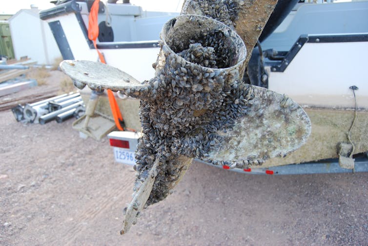
A boat propeller encrusted with zebra mussels. NPS/Flickr
The zebra mussel has been a poster child for invasive species ever since it unleashed economic and ecological havoc on the Great Lakes in the late 1980s. Yet despite intensive efforts to control it and its relative, the quagga mussel, these fingernail-sized mollusks are spreading through U.S. rivers, lakes and bays, clogging water supply pipes and altering food webs.
Now, the mussels threaten to reach the country’s last major uninfested freshwater zones to the west and north: the Columbia River Basin in Washington and Oregon, and the waterways of Alaska.
As an environmental historian, I study how people’s attitudes toward nonindigenousspecies have changed over time. Like many other aquatic aliens, zebra and quagga mussels spread to new bodies of water when people move them, either accidentally or deliberately. Human-built structures, such as canals, and debris can also help invaders bypass natural barriers.
In my view, reducing the damage from these outbreaks – and preventing them if possible – requires understanding that human activities are the root cause of costly biological invasions.
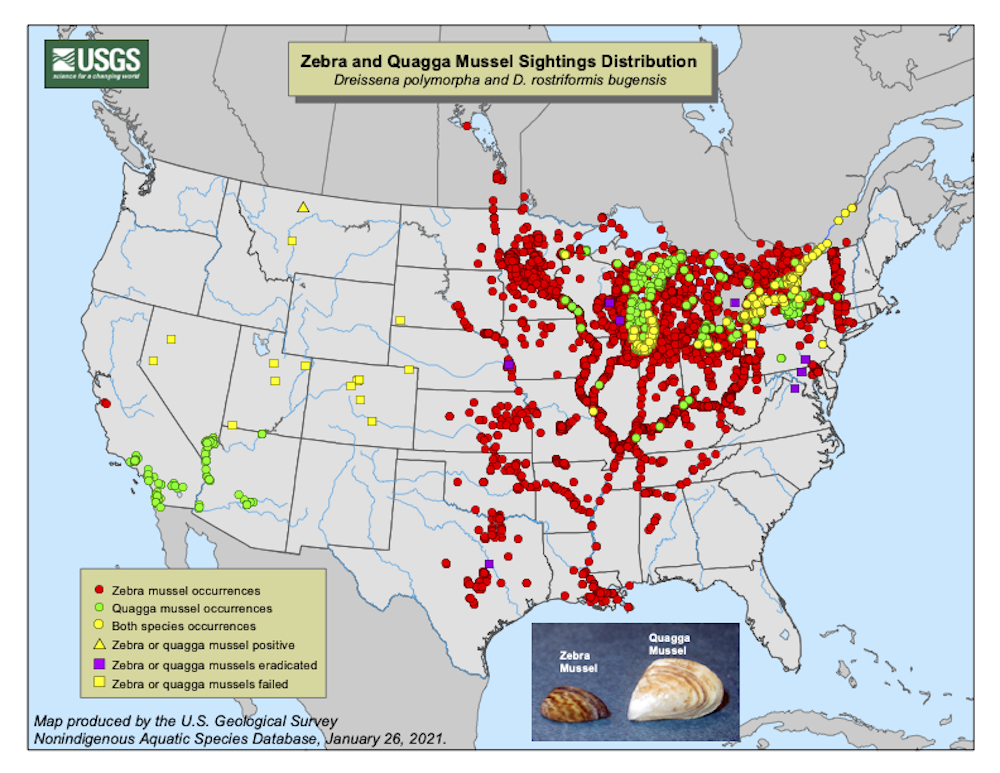
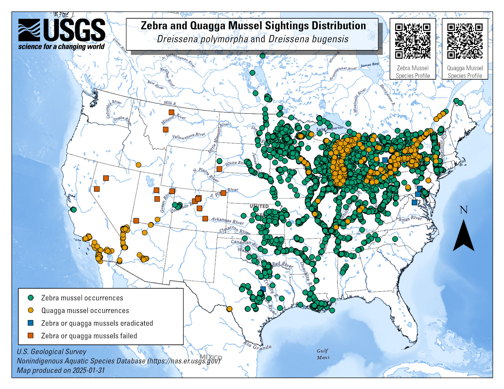
Zebra and quagga mussels have moved east, south and west from the Great Lakes into many other U.S. rivers and lakes.USGS
Past transoceanic invasions
European exploration of the Americas between the late 1400s and 1700s led to massive transfers of organisms, a process known as the Columbian exchange, named for Christopher Columbus. Many investors grew rich through shipping livestock and plantation crops across the oceans. Transatlantic travel also introduced microbes that caused infectious diseases, such as smallpox and measles, that killed millions of Native Americans who lacked immunity.
During the 19th century, European and North American colonizers established acclimatization societies to import desired species of foreign animals and plants to use for food, sport hunting or beautifying their environments. Many such efforts failed when the introduced species could not adapt to their new conditions and died off.
Others triggered legendary ecological disasters. For example, after the Victorian Acclimatisation Society released European rabbits in Australia in 1859, they multiplied rapidly. Feral rabbits and other introduced species like cats have destroyed millions of Australia’s native plants and animals.
Shipping has also accidentally spread alien species. Human-built canals made it easier to transport goods, but also provided new pathways for aquatic pests.
During the late 19th and early 20th centuries, for example, Canada expanded the Welland Canal between Lake Ontario and Lake Erie to allow large ships to bypass Niagara Falls. By 1921, these technological improvements enabled the sea lamprey, a parasitic fish, to move from Lake Ontario into the upper Great Lakes, where it is still a serious threat to commercial fisheries.
In 1959, the U.S. and Canada opened the St. Lawrence Seaway, a maritime network that connects the Atlantic with the Great Lakes. Ocean-going ships using the seaway brought along stowaway species in ballast water – tanks full of water, used to keep the ships stable at sea.
When ships reached their destinations and flushed out their ballast tanks, they released alien plants, crustaceans, worms, bacteria and other organisms into local waters. In a milestone 1985 study, Williams College biologist Jim Carlton described how ballast water discharges provided a powerful vehicle for biological invasions.
The Great Lakes mussel invasion
Zebra mussels are native to the Black and Caspian Seas. They are thought to have entered North America in the early 1980s and were formally identified in the Great Lakes in 1988, followed by quagga mussels in 1989.
Soon the striped bivalves were blanketing hard surfaces throughout the lakes and washing up on shorelines, cutting beachgoers’ feet. Zebra mussels clogged intake pipes at drinking water treatment plants, power stations, fire hydrants and nuclear reactors, dangerously reducing water pressure and requiring expensive remedies.
Mollusks are filter feeders that typically make water clearer. But zebra and quagga mussels filtered so much plankton from the water that they starved native mussels and fostered harmful algal blooms. The invaders also passed deadly type E botulism to fish-eating birds.
By the early 1990s, 139 alien species had become established in the Great Lakes, with almost one-third arriving after the St. Lawrence Seaway opened. Ship-related introductions, along with other pathways, such as aquaculture and aquarium and bait fish releases, transformed the Great Lakes into one of the world’s most invaded freshwater ecosystems.
Local officials grapple with a spreading infestation of zebra mussels in Lake Brownwood in central Texas.
Early policy responses
The U.S. began regulating ballast water management in 1990 but had trouble closing loopholes. For instance, vessels declaring that they had no pumpable ballast water on board did not have to empty and refill their ballast tanks in the middle of a voyage with clean ocean water. As a result, live freshwater organisms lurking in tank sediments could still be released in vulnerable ports.
Finally, after comprehensive studies, the U.S. and Canada in 2006 required ships to flush tanks containing residual sediment with seawater. A 2019 assessment found that only three new species became established in the Great Lakes from 2006-2018, none of them via ship ballast.
Now, however, other human activities are increasingly contributing to harmful freshwater introductions – and with shipping regulated, the main culprits are thousands of private boaters and anglers.
Stemming the westward spread
Zebra and quagga mussels are moving west and south from the Great Lakes, attached to private boats or carried in bilge water and bait buckets. They have been found in Nevada, Arizona, California, Utah, Colorado and Montana.
If the mussels reach the Columbia River ecosystem, they will threaten native wildlife and irrigation pipelines and dams that are vital for agriculture and hydropower. Government officials, wildlife managers and scientists are working hard to prevent that from happening.
Public outreach is critical. Travelers who transport their boats without decontaminating them can transfer zebra and quagga mussels to inland rivers and lakes. The mussels can survive out of water in hot places for weeks, so it’s important for boaters and anglers to clean, drain and dry boating equipment and fishing gear.
Aquarium keepers can help stem the tide by disinfecting tanks and accessories in order to prevent accidental releases of live organisms into public waterways, and by being vigilant about their purchases. In 2021, zebra mussels were detected in imported moss balls sold as aquarium plants across the U.S. and Canada.
The U.S. Geological Survey maintains a website where people can report sightings of nonindigenous aquatic species, potentially spotting new infestations during the critical early phase before they become established.
Maintaining public support
Some of these efforts have shown encouraging results. Since 2008, Colorado has operated a rigorous boat inspection program that has kept zebra and quagga mussels out of state waters.
But prevention isn’t always popular. Officials closed the San Justo Reservoir in central California to the public in 2008 after zebra mussels were found there; residents argue that the closure has harmed the community and are lobbying the federal government to eradicate the mussels in order to reopen it for fishing.
Mitigating the destructive effects of invasive species is a complex mission that may not have an obvious endpoint. It requires scientific, technological and historical knowledge, political will and skill to persuade the public that everyone is part of the solution.
LAKE COUNTY, Calif. — Lake County Animal Care and Control has more young dogs waiting for homes this week.
Dogs available for adoption this week include mixes of Belgian malinois, border collie, bull terrier, Great Pyrenees, Labrador retriever, pit bull, shar pei, shepherd, terrier and treeing walker coonhound.
Dogs that are adopted from Lake County Animal Care and Control are either neutered or spayed, microchipped and, if old enough, given a rabies shot and county license before being released to their new owner. License fees do not apply to residents of the cities of Lakeport or Clearlake.
The following dogs at the Lake County Animal Care and Control shelter have been cleared for adoption.
Call Lake County Animal Care and Control at 707-263-0278 or visit the shelter online for information on visiting or adopting.
“Hoss” is an 8-year-old male Chinese Shar-Pei in kenne lNo. 18, ID No. LCAC-A-3638. Photo courtesy of Lake County Animal Care and Control. ‘Hoss’
“Hoss” is an 8-year-old male Chinese Shar-Pei with a short tan coat.
He is in kenne lNo. 18, ID No. LCAC-A-3638.
This 9-year-old female shar pei-pit bull mix is in kennel No. 19, ID No. LCAC-A-3622. Photo courtesy of Lake County Animal Care and Control. Shar Pei-pit bull mix
This 9-year-old female shar pei-pit bull mix has a short black and white coat.
She is in kennel No. 19, ID No. LCAC-A-3622.
“Missy” is a 3-year-old female pit bull terrier in kennel No. 20, ID No. LCAC-A-3524. Photo courtesy of Lake County Animal Care and Control. ‘Missy’
“Missy” is a 3-year-old female pit bull terrier with a black and white coat.
She is in kennel No. 20, ID No. LCAC-A-3524.
This 1-year-old female shepherd mix is in kennel No. 22, ID No. LCAC-A-3705. Photo courtesy of Lake County Animal Care and Control. Female shepherd mix
This 1-year-old female shepherd mix has a short black and tan coat.
She is in kennel No. 22, ID No. LCAC-A-3705.
“Autumn” is a 6-year-old female treeing walker coonhound in kennel No. 24, ID No. LCAC-A-1776. Photo courtesy of Lake County Animal Care and Control. ‘Autumn’
“Autumn” is a 6-year-old female treeing walker coonhound with a tricolor coat.
She is in kennel No. 24, ID No. LCAC-A-1776.
This 1-year-old male Belgian malinois is in kennel No. 27, ID No. LCAC-A-3694. Photo courtesy of Lake County Animal Care and Control. Male Belgian malinois
This 1-year-old male Belgian malinois has a short black and tan coat.
He is in kennel No. 27, ID No. LCAC-A-3694.
This 1-year-old male pit bull-bull terrier is in kennel No. 28, ID No. LCAC-A-3644. Photo courtesy of Lake County Animal Care and Control. Pit bull-bull terrier mix
This 1-year-old male pit bull-bull terrier has a short white coat.
He is in kennel No. 28, ID No. LCAC-A-3644.
This 3-year-old female Great Pyrenees is in kennel No. 29, ID No. LCAC-A-3669. Photo courtesy of Lake County Animal Care and Control. Female Great Pyrenees
This 3-year-old female Great Pyrenees has a white coat.
She is in kennel No. 29, ID No. LCAC-A-3669.
This young male border collie-Labrador retriever mix is in kennel No. 30, ID No. LCAC-A-3646. Photo courtesy of Lake County Animal Care and Control. Border collie-Labrador retriever mix
This young male border collie-Labrador retriever mix has a short black and white coat.
He is in kennel No. 30, ID No. LCAC-A-3646.
This 1-year-old female German shepherd is in kennel No. 34, ID No. LCAC-A-3685. Photo courtesy of Lake County Animal Care and Control. Female German shepherd
This 1-year-old female German shepherd has a tan and black coat.
She is in kennel No. 34, ID No. LCAC-A-3685.
Email Elizabeth Larson at This email address is being protected from spambots. You need JavaScript enabled to view it.. Follow her on Twitter, @ERLarson, or Lake County News, @LakeCoNews.
Food deserts. Poor housing conditions. Lack of community investment.
These challenges may not always come to mind when people think about how to improve America’s public schools.
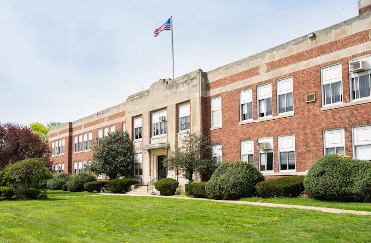
But when my colleagues and I studied the 21st Century School Buildings Program, a US$1.1 billion school building and renovation initiative in Baltimore, these were the kinds of issues that staff from community-based organizations, schools, philanthropic organizations and city agencies hoped to address through improved school facilities.
Schools are the “hubs and hearts” of neighborhoods, as one community member told us during our research in the Southeast, Southwest and Cherry Hill sections of Baltimore. If, as one community school coordinator shared, schools want to achieve their goals to educate students, they should strengthen the communities that surround them.
Making schools accessible to residents can strengthen the connection between schools and neighborhoods.
In Southeast, one school included space to host programs for newcomers to the United States. Those programs provided English language classes for students, as well as academic and social supports to help students and their families understand U.S. schools’ culture.
As a community school coordinator in Cherry Hill told us: “We can promote events and workshops and services to the entire community because they’re all happening here.”
However, although schools in our study were open in theory, they were not always easily accessible. Organizations sometimes encountered barriers, such as needing permits or having to pay fees to cover custodians or security, to host public events at schools. Our research suggests that collaboration between school districts and other city agencies can help make shared spaces more accessible by using a broader definition of community beyond just the school community, such as parents and teachers. They can also eliminate required permits and fees.
2. Meet community needs
Schools in our study partnered with community-based organizations and governmental agencies to provide services to meet their community’s needs.
In Southwest, a school partnered with local organizations to offer families a food pantry and adult education, including GED preparation.
In Cherry Hill, where access to full-service grocery stores is limited, a community school coordinator reached out to a local organization to host a morning produce market at the school once per week. A representative from the city housing authority also visited the school to make it easier for families to file complaints about poor housing conditions, such as mold.
3. Engage the community
Across all three communities, officials sought input from students, families and residents about the renovation plans or designs for new schools. They also provided updates about the construction process.
Other projects included creating a walking school bus – where adult volunteers walked with children to school – in Southwest to help students travel to and from school safely.
In Southeast, parents’ advocacy to improve school facilities – such as heating and cooling systems – helped them become more involved in their neighborhoods. Families from the schools have participated in neighborhood beautification projects, community cleanups and other activities.
Strong family and community engagement, however, is not a given. Successful partnerships also require trust among schools, families and community members. In Southwest, one school’s construction resulted in another school’s closure. The students from the old school would be sent to the new school. Families from the closed school saw their school as a safe haven and fought to prevent its closure. According to one community advocate, the process of closing the school led some families to lose faith in community organizations, the school district and city agencies.
4. Attract new residents and development
Many stakeholders that we talked to saw the new and renovated schools as a way to bring new residents, businesses and development to their communities.
In Southwest, one stakeholder told us that the new school building has led to greater interest among residents to invest in the neighborhood. “There’s a lot of residents who are organized and involved in these neighborhoods. They’re saying, ‘Hey, we got a new school. Let’s build up this neighborhood.’” Similarly, families in Southeast have become more excited about the renovated schools. A nonprofit representative said, “We see it on Facebook feeds. Because we put the [school] designs out there as much as we can, they’re starting to think, ‘Maybe I’ll put my child there.’”
However, as schools attract more residents, people in Cherry Hill and Southeast wanted to be sure existing residents weren’t pushed out. In both neighborhoods, school and community partners are creating pathways to help existing residents to purchase homes in their neighborhoods. This includes home ownership counseling and loan programs for qualifying residents.
Education will always be the primary function of America’s public schools. But as our research suggests, schools need not only concern themselves with what takes place in the classroom – they can also play an important part in improving the conditions in the surrounding community.
LAKE COUNTY, Calif. — A small wildland fire in Clearlake on Saturday afternoon temporarily displaced some nearby residents.
The Park fire was first dispatched just before 1:15 p.m. Saturday in the area of 18th Avenue and Old Highway 53, across from Adventist Health Clear Lake.
Firefighters from Lake County Fire Protection District and Cal Fire arrived on scene quickly and within about 20 minutes evacuations started in the Clear Lake Village area.
Cal Fire dispatched air attack and tankers which began to work in the area, where power lines also were reported to be down.
Air attack began to release the tankers from the scene at 2 p.m. and minutes later forward progress was reported to have been stopped. The estimated size was about five acres.
There were no reports of damaged structures.
Evacuations remained in place until just after 4 p.m., while a road closure on Old Highway 53 between Airport Road and Lakeview Way remained in effect, according to the Clearlake Police Department.
While residents were required to stay out of their homes, officials opened the city’s senior and community center on Bowers Avenue to provide them with services and a place to wait.
Information on a cause was not immediately available.
Email Elizabeth Larson at This email address is being protected from spambots. You need JavaScript enabled to view it.. Follow her on Twitter, @ERLarson, or Lake County News, @LakeCoNews.
Virginia T. Norwood, known as the person who could solve impossible problems, played a crucial role in the development of the first space-based multispectral scanner instrument that flew on Landsat 1 and made the mission a success. Working together with NASA, USGS, university researchers, and her team at Hughes, Norwood successfully yoked the pioneering technology that made regular digital imagery of Earth from space possible. Credits: NASA's Goddard Space Flight Center.
On a warm July day in 1972, NASA launched a new Earth-imaging satellite called the Earth Resources Technology Satellite.
“ERTS” was the first satellite of what later became NASA and the U.S. Geological Survey’s Landsat Program, an ambitious effort with a vision of documenting the entirety of Earth from space.
The first Landsat was so successful it led to a series of satellites that have created the longest contiguous record of Earth’s surface from a space-eye view – that continues growing to this day, 50 years later.
“The early Landsats revolutionized the way we observed the Earth from space,” said Jim Irons, director emeritus of the Earth Sciences Division at NASA’s Goddard Space Flight Center in Greenbelt, Maryland.
Since its debut, Landsat has amassed over 10 million images. These images, also called scenes, show current snapshots of land and coasts, but pair with images of years past and they also reveal changes through time — glaciers slowly disappearing, or urban spaces sprawling across the landscape.
These scenes and time series have myriad applications around the globe: Hydrologists use them to track how rivers change; ecologists use them to determine the extent of deforestation; farmers and agricultural organizations use them to analyze crop health.
During Landsat’s five decades, eight different Landsat satellites have circled the planet. Currently, three continue to collect global observations from space: Landsats 7, 8, and 9. (Landsat 6 was lost shortly after launch.) Landsat 9, the newest of the bunch, entered orbit in fall of 2021. While Landsat 9 shares similarities with its predecessors, the Landsat satellite design has evolved immensely since the program’s emergence.
Artist's conception of the Landsat 9 spacecraft, the ninth satellite launched in the long-running Landsat program, high above the U.S. Credit: NASA. Early days
The first two Landsats could see in four spectral bands, or wavelengths of light: visible light in red and green, and two near-infrared bands. The near-infrared allowed the satellites to distinguish vegetation from other land cover and assess plant health, while the visible wavelengths differentiated bright surfaces, like snow, deserts and clouds, from dark surfaces like water. Each scene encompassed a roughly square area of around 115 miles to a side.
The first Landsats’ data transmitted to Earth were recorded on magnetic tapes, the same basic tech as music cassettes – but much bigger: The bulky wideband video tape recorders that flew on the first three Landsats each had 1,800 feet of tape and weighed in at 76 pounds apiece.
From this data, scientists generated and printed out photographic images. These photos gave a general space-eye view of an area, but the real power of the data came after computer algorithms helped scientists and resource managers to more efficiently identify the categories of land cover they represented.
Printers spat out paper maps with letter, number, and symbol combinations, where each character represented a land cover category, such as cropland or forest.
“You’d get out colored pencils or magic markers and you’d color the different characters, each with its own color,” Irons said. “That would give you an early version of a color-coded land cover map.”
Goddard was NASA’s home for Landsat going back to the program’s inception. Irons served as the deputy project scientist on Landsat 7 and project scientist on Landsat 8, helping to further shape the program and playing a pivotal role in the satellites’ development. In his 43 years working with Landsat, he’s watched the satellites grow into what they are today.
Landsat data in the ’80s and ’90s were critical to many projects, such as understanding the extent of tree loss in rainforests, Irons said. Likewise, Chris Neigh, Landsat 9’s project scientist at Goddard, uses time series to watch the slow northward creep of boreal forests, as the trees progressively inch toward the pole in response to global warming.
The long pedigree of Landsat data is essential for this kind of research, Neigh added: there are few other records to reference, and none as comprehensive.
The Earth Resources Technology Satellite (ERTS, later renamed Landsat 1) launched aboard a Delta 900 from Vandenberg Air Force Base on July 23, 1972. Credits: NASA photography courtesy Landsat science team. 2000s: Free access to the Landsat archive
After a failed launch of Landsat 6, Landsat 7 embarked successfully in 1999, equipped with improved instruments and roughly double the resolution of its predecessors. NASA deliberated for seven years between the launches of Landsat 7 and Landsat 8, trying to decide how to move forward with the program before beginning another seven-year process of building and launching the next satellite.
In that time, image management returned from commercial providers to USGS, which made the entire Landsat archives freely available in 2008. Image requests skyrocketed. Landsat all-time downloads topped 100 million scenes in 2020, and the number continues to rise.
As Landsat continues to transform, the people and projects that use it grow too: The United States Department of Agriculture relies on Landsat to guide farmers in watering practices and land management; climate scientists watch glaciers retreat as temperatures rise; in the drought-stricken West, water managers monitor reservoir levels.
Landsat’s next adventure
With a data user community that keeps growing, scientists and engineers are already looking forward to the next mission. NASA and USGS are developing options for the next iteration of Landsat, currently called Landsat Next.
Landsat’s eyes in space have granted new opportunities for understanding our changing planet, but the simple awe of seeing Earth is sometimes forgotten, Irons said.
“We can’t all be astronauts,” Irons said. “But if we look at Landsat images, we can understand what the Earth would look like if we were orbiting the Earth in space.”
Jude Coleman works for NASA’s Goddard Space Flight Center in Greenbelt, Maryland.
The first fully operational Landsat image taken on July 25, 1972, of Dallas, Texas, inaugurating a 40-year run when the first satellite was known as the Earth Resources Technology Satellite, or ERTS. Credits: NASA’s Earth Observatory.
The PolyCam aboard NASA's OSIRIS-REx spacecraft provided high-resolution, microscope-like images of asteroid Bennu’s surface. This made it possible for researchers to map more than 1,500 rock fractures. Slide left on the example image to see the fractures highlighted in red. Credits: NASA/Goddard/University of Arizona. Scientists from NASA’s OSIRIS-REx mission recently learned that surface regeneration happens a lot quicker on asteroids than on Earth.
By analyzing rock fractures on asteroid Bennu from high-resolution images taken by the OSIRIS-REx spacecraft, the team discovered that the Sun’s heat fractures rocks on Bennu in just 10,000 to 100,000 years.
This information will help scientists estimate how long it takes boulders on asteroids like Bennu to break down into smaller particles, which may either eject into space or stay on the asteroid’s surface.
Tens of thousands of years might sound pretty slow, but “we thought surface regeneration on asteroids took a few millions of years,” said Marco Delbo, senior scientist at Université Côte d'Azur, CNRS, Observatoire de la Côte d'Azur, Laboratoire Lagrange, Nice, France, and lead author of a paper published June 2022 in Nature Geoscience. “We were surprised to learn that the aging and weathering process on asteroids happens so quickly, geologically speaking.”
Although landslides, volcanoes, and earthquakes can change the surface suddenly on Earth, usually changes are gradual. Water, wind, and temperature changes slowly break down rock layers, creating new surfaces over millions of years.
For example, if you were to hike into the Grand Canyon, you would see distinct rock layers; the top layers tend to be the youngest rocks, dating around 270 million years old, and the layers at the bottom of the canyon are the oldest, about 1.8 billion years old.
According to the U.S. National Park Service, the Colorado River has been carving down rocks in the Grand Canyon for 5 million to 6 million years.
Rapid temperature changes on Bennu create internal stress that fractures and breaks down rocks, similar to how a cold glass breaks under hot water. The Sun rises every 4.3 hours on Bennu. At the equator, daytime highs can reach almost 260 F (about 127 C), and nighttime lows plummet to nearly minus 10 F (about minus 23 C).
OSIRIS-REx scientists spotted cracks in the rocks in spacecraft images from the first surveys of the asteroid. The fractures seemed to point in the same direction, “a distinct signature that temperature shocks between the day and the night could be the cause,” said Delbo.
Delbo and his colleagues measured the length and angles of more than 1,500 fractures in OSIRIS-REx images by hand: some shorter than a tennis racket, others longer than a tennis court. They found the fractures predominantly align in the northwest-southeast direction, indicating they were caused by the Sun, which is shown here to be the primary force changing Bennu’s landscape.
“If landslides or impacts were moving boulders faster than the boulders were cracking, the fractures would point in random directions,” said Delbo.
The scientists used a computer model and their fracture measurements to calculate the 10,000 to 100,000-year timeframe for thermal fractures to propagate and split rocks.
“The thermal fractures on Bennu are quite similar to what we find on Earth and on Mars in terms of how they form,” said Christophe Matonti, a co-author of the paper at Université Côte d’Azur, CNRS, Observatoire de la Côte d’Azur, Géoazur, Sophia-Antipolis, Valbonne, France. “It is fascinating to see that they can exist and are similar in very ‘exotic’ physical conditions [low gravity, no atmosphere], even compared to Mars.”
“Keep in mind, the topography of Bennu is young, but the rocks on the asteroids are still billions of years old and hold valuable information about the beginning of the solar system,” said Jason Dworkin, OSIRIS-REx project scientist at NASA’s Goddard Space Flight Center in Greenbelt, Maryland.
OSIRIS-REx (Origins, Spectral Interpretation, Resource Identification, Security-Regolith Explorer) will return a sample from Bennu to Earth on Sept. 24, 2023. “We will be able to learn more details about the age of the surface when we are able to directly study the sample,” said Dworkin.
Goddard provides overall mission management, systems engineering, and the safety and mission assurance for OSIRIS-REx. Dante Lauretta of the University of Arizona, Tucson, is the principal investigator. The university leads the science team and the mission's science observation planning and data processing. Lockheed Martin Space in Littleton, Colorado, built the spacecraft and provides flight operations.
Goddard and KinetX Aerospace are responsible for navigating the OSIRIS-REx spacecraft. OSIRIS-REx is the third mission in NASA's New Frontiers Program, managed by NASA's Marshall Space Flight Center in Huntsville, Alabama, for the agency's Science Mission Directorate Washington.
Rani C. Gran works for NASA's Goddard Space Flight Center in Greenbelt, Maryland.
LAKE COUNTY, Calif. — After a four-day-long closure, the Sutter Lakeside Birth Center has reopened.
“As of 4:30 p.m. Saturday, the obstetric bypass period ended and Sutter Lakeside Hospital is again able to provide obstetric services,” Sutter Health spokeswoman Monique Binkley Smith told Lake County News.
The hospital closed the birth center on Tuesday afternoon and went on “diversion” due to lack of an obstetrician, as Lake County News has reported.
While on diversion, Sutter Lakeside referred patients to Adventist Health Clear Lake — the only other facility in Lake County where babies can be delivered — as well as hospitals in Mendocino, Napa and Sonoma counties.
Hospital officials originally expected to reopen on the morning of Wednesday, July 27, at the latest.
The California Nurses Association criticized Sutter Lakeside for having relied on just two obstetric providers.
The hospital has so far not responded to requests from Lake County News to elaborate on what led to the lack of providers last week.
The birth center reportedly delivers around 300 babies a year, about half of all the babies born in Lake County on an annual basis.
Email Elizabeth Larson at This email address is being protected from spambots. You need JavaScript enabled to view it.. Follow her on Twitter, @ERLarson, or Lake County News, @LakeCoNews.
LAKE COUNTY, Calif. — The Board of Supervisors this week gave its support to a plan for recruiting a new Community Development Department director.
The current director, Mary Darby, gave the board her resignation after a closed session evaluation on Tuesday, July 12. It’s effective Nov. 4.
Human Resources Director Pam Samac laid out the plan for the recruitment to find the seventh director for Community Development since 2016.
She said they opened the recruitment on July 14. If they don’t get a decent pool of qualified candidates, they want to put it out to 10 recruiters to find one to lead the process.
After reviewing the candidates, if it’s warranted, Samac wants to schedule interviews with the board.
Supervisor Bruno Sabatier said he wanted the county to use professional recruitment firms to find department director jobs.
Samac said it’s possible the county could get a number of good candidates as they did recently for the assistant county administrative officer without using a recruiter. She added that during the last six months ago the county has started getting better candidates for senior positions.
She advocated for the county starting the recruitment on its own and waiting three weeks before paying $25,000 to $30,000 for a recruiter.
At the same time, she said they could put out a bid request to recruiters so that it can be underway while the county is taking initial applications.
The county is now conducting another recruitment for a Public Health officer. Samac said the recruitment agencies her recruiter network uses are very busy, and have been saying they are too busy to even give quotes for services. However, that could have changed and she said they could ask for bids again.
Samac said she would have the first review of applications on Aug. 9. At that point, she said they already had one qualified applicant.
She said that they could make an assessment on Aug. 9 about what applicants they have. “I don’t believe that you have to have four or five to compare and contrast if you have one great candidate.”
At the suggestion of County Administrative Officer Susan Parker, the board agreed to have a standing item on its closed session agenda to discuss the recruitment.
Darby suggested to the board that they also advertise the job with the American Planning Association, as she said that’s where all the certified planners are and the county can get some great candidates there.
Email Elizabeth Larson at This email address is being protected from spambots. You need JavaScript enabled to view it.. Follow her on Twitter, @ERLarson, or Lake County News, @LakeCoNews.
LAKE COUNTY, Calif. — As Sutter Lakeside Hospital’s Birth Center remains closed due to lack of a dedicated physician, officials with the county, other hospitals and the nurses union have offered additional details on the situation.
Sutter Lakeside closed its birth center on Tuesday afternoon at 4 p.m. due to having no available obstetrician to deliver babies, as Lake County News has reported.
At that point, the hospital went on “diversion” and began directing expectant mothers to other hospitals around the region.
The hospital said it anticipates resolving the situation to be resolved by 7 a.m. Wednesday, July 27, and that it is “actively working with community resources to help patients access appropriate care and to facilitate transfers to other hospitals as necessary.”
The California Nurses Association — whose members are in ongoing negotiations with Sutter Health and conducted an informational picket earlier this year over issues including safety and staffing — weighed in on the situation, calling on Sutter “to immediately provide the community with a comprehensive plan to ensure safe, stable and consistent obstetric services.”
The union accused Sutter Health of putting profits over patients, noting, “Sutter management has relied on just two obstetric providers, throughout two years of pandemic instability, despite repeated warnings from Registered Nurses and providers.”
The closure of the Sutter Lakeside Birth Center left only one place to deliver in Lake County — Adventist Health Clear Lake.
“We are prepared and ready to accept birthing mothers who are being diverted,” Kim Lewis, spokesperson for Adventist Health Clear Lake, told Lake County News on Thursday.
Lewis said Sutter had reached out to Adventist regarding its action, “and we are working closely with them and have a plan in place.”
In addition to Adventist Health Clear Lake, Sutter Lakeside is reportedly directing patients to Kaiser Santa Rosa, Queen of the Valley in Napa and Santa Rosa Memorial Hospital.
On Thursday, Adventist Health Ukiah Valley contacted Lake County News to report that it also is welcoming birth center patients that are being diverted from Sutter Lakeside.
County officials reported on Thursday that they also are working with Sutter Lakeside to address the matter.
“County of Lake Health Services was made aware of this before its occurrence and has been supporting Sutter Lakeside where possible,” Dwight Coddington, spokesman for the Lake County Health Services Department, told Lake County News in a Thursday email.
Coddington said that if a patient does require an obstetrician they will be referred to Sutter in Santa Rosa, and that other providers — such as Adventist Hospital and the regional hospitals where patients are being referred — aren’t being impacted due to Sutter Lakeside’s obstetrics bypass.
The California Nurses Association told Lake County News that it is “deeply concerned for the patients and families of Lake County as well as adjacent Napa and Mendocino counties with the alarming news that Sutter Lakeside Hospital has failed to secure stable obstetric services resulting in temporary closure or ‘diversion’ of its perinatal services.”
Noting that the rural hospital provides vital health care services, including perinatal services to Lake, Napa and Mendocino County families, the union said, “This temporary closure or ‘diversion’ adds significant time and travel to a journey that can and often does cause significant risk to the well-being of the expectant mother and baby.”
Email Elizabeth Larson at This email address is being protected from spambots. You need JavaScript enabled to view it.. Follow her on Twitter, @ERLarson, or Lake County News, @LakeCoNews.

 How to resolve AdBlock issue?
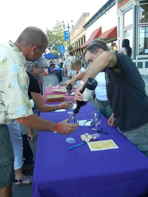


