This female domestic short hair kitten is in cat room kennel No. A1, LCAC-A-1173. Photo courtesy of Lake County Animal Care and Control. Domestic short hair kittens
This female domestic short hair kitten has an all black coat.
She is in cat room kennel No. A1, ID No. 1173.
This male domestic short hair kitten is in cat room kennel No. 11c, ID No. LCAC-A-1144. Photo courtesy of Lake County Animal Care and Control. Male domestic shorthair kitten
This male domestic short hair kitten has a gray tabby coat.
He is in cat room kennel No. 11c, ID No. LCAC-A-1144.
This female domestic short hair kitten is in cat room kennel No. 11d, ID No. LCAC-A-1145. Photo courtesy of Lake County Animal Care and Control. Female domestic shorthair kitten
This female domestic short hair kitten has a black coat.
She is in cat room kennel No. 11d, ID No. LCAC-A-1145.
This 3-year-old female domestic medium hair cat is in cat room kennel No. 58, ID No. LCAC-A-1029. Photo courtesy of Lake County Animal Care and Control. Domestic medium hair cat
This 3-year-old female domestic medium hair cat has a brown tabby coat.
She is in cat room kennel No. 58, ID No. LCAC-A-1029.
This male domestic shorthair is in cat room kennel No. 120, ID No. LCAC-A-874. Photo courtesy of Lake County Animal Care and Control. Male domestic shorthair
This male domestic shorthair has a gray and white coat.
He is 1-year-old and weighs nearly 6 pounds.
He is in cat room kennel No. 120, ID No. LCAC-A-874.
This 2-year-old female domestic shorthair cat is in cat room kennel No. C123, ID No. LCAC-A-1152. Photo courtesy of Lake County Animal Care and Control. Female domestic shorthair
This 2-year-old female domestic shorthair cat has a white coat and blue eyes.
She is in cat room kennel No. C123, ID No. LCAC-A-1152.
Email Elizabeth Larson at This email address is being protected from spambots. You need JavaScript enabled to view it.. Follow her on Twitter, @ERLarson, or Lake County News, @LakeCoNews.
LAKE COUNTY, Calif. — Lake County Animal Care and Control has several big dogs ready to be adopted this week.
Dogs available for adoption this week include mixes of basset, hound, husky, Labrador retriever, pit bull, Rhodesian Ridgeback, Rottweiler and shepherd.
Dogs that are adopted from Lake County Animal Care and Control are either neutered or spayed, microchipped and, if old enough, given a rabies shot and county license before being released to their new owner. License fees do not apply to residents of the cities of Lakeport or Clearlake.
The following dogs at the Lake County Animal Care and Control shelter have been cleared for adoption (additional dogs on the animal control website not listed are still “on hold”).
This 2-year-old male Labrador retriever is in kennel No. 19, ID No. LCAC-A-1349. Photo courtesy of Lake County Animal Care and Control. Male Labrador retriever
This 2-year-old male Labrador retriever has a short black coat with white markings.
He is in kennel No. 19, ID No. LCAC-A-1349.
This 2-year-old female basset-husky-hound is in kennel No. 21, ID No. LCAC-A-1331. Photo courtesy of Lake County Animal Care and Control. Basset-husky-hound mix
This 2-year-old female basset-husky-hound has a short black and tan coat.
She is in kennel No. 21, ID No. LCAC-A-1331.
“Dusty” is a 2-year-old female pit bull terrier mix in kennel No. 22, ID No. LCAC-A-611. Photo courtesy of Lake County Animal Care and Control. ‘Dusty’
“Dusty” is a 2-year-old female pit bull terrier mix with a short gray coat.
She is in kennel No. 22, ID No. LCAC-A-611.
“Jim” is a 2-year-old pit bull terrier mix in kennel No. 23, ID No. LCAC-A-810. Photo courtesy of Lake County Animal Care and Control. ‘Jim’
“Jim” is a 2-year-old pit bull terrier mix with a short black and white coat.
He is in kennel No. 23, ID No. LCAC-A-810.
“Rosco” is 3-year-old a male Rhodesian Ridgeback-Shepherd mix in kennel No. 25, ID No. LCAC-A-1205. Photo courtesy of Lake County Animal Care and Control. ‘Rosco’
“Rosco” is 3-year-old a male Rhodesian Ridgeback-Shepherd mix with a short tan coat.
He is in kennel No. 25, ID No. LCAC-A-1205.
This female Rottweiler-pit bull mix is in kennel No. 27, ID No. LCAC-A-731. Photo courtesy of Lake County Animal Care and Control. Rottweiler-pit bull mix
This 1-year-old female Rottweiler-pit bull mix has a short black coat.
She has been spayed.
She is in kennel No. 27, ID No. LCAC-A-731.
This 4-year-old female pit bull terrier mix is in kennel No. 29, ID No. LCAC-A-812. Photo courtesy of Lake County Animal Care and Control. Female pit bull terrier
This 4-year-old female pit bull terrier mix has a short white coat.
She is in kennel No. 29, ID No. LCAC-A-812.
“Bubba” is a male pit bull terrier mix in kennel No. 30, ID No. LCAC-A-1306. Photo courtesy of Lake County Animal Care and Control. ‘Bubba’
“Bubba” is a male pit bull terrier mix with a short black coat.
He is in kennel No. 30, ID No. LCAC-A-1306.
“Ghost” is a 2-year-old female husky in kennel No. 34, ID No. LCAC-A-1167. Photo courtesy of Lake County Animal Care and Control. ‘Ghost’
“Ghost” is a 2-year-old female husky with an all-white coat and blue eyes.
She is in kennel No. 34, ID No. LCAC-A-1167.
Email Elizabeth Larson at This email address is being protected from spambots. You need JavaScript enabled to view it.. Follow her on Twitter, @ERLarson, or Lake County News, @LakeCoNews.
LAKE COUNTY, Calif. — This week the Lakeport Police Department reported on work it did in collaboration with the Clearlake Police Department as part of an Alcoholic Beverage Control.
On June 9, 2020, the Lakeport Police Department and Clearlake Police Department were awarded a $24,975 grant from the California Alcoholic Beverage Control, or ABC, to enforce alcohol-related crime and educate their communities on alcohol-related laws.
On July 21, 2020, the Lakeport City Council approved a resolution to accept the grant funding and go into partnership with ABC.
During the course of the grant, because of the ongoing COVID-19 pandemic, grant funds awarded to the departments were cut in half to $12,478.
The grant funds remaining were used to conduct a total of four Informed Merchants Preventing Alcohol-Related Crime Tendencies, or IMPACT, operations as well as several other grant-related enforcement operations including alcohol-related crime and DUI saturation patrols.
In total, 34 IMPACT Inspections were completed over the course of the four operations. Of the 34 businesses inspected, 13 businesses were found to be out of compliance and were educated on how to come into compliance with California law.
During the other operations conducted with grant funds, a total of eight individuals were arrested or criminally cited for various crimes ranging from DUI, to purchasing alcohol for a minor to felony warrants.
During these operations, the agencies also found that theft of alcohol by both adults and minors is a major continuing problem leading to other criminal offenses.
In particular, one Lakeport location is a regular target of these thefts. Police said they will be following up on this problem with business locations in an effort to eliminate alcohol theft.
On June 26, during an alcohol-involved crime/DUI saturation operation, an officer assigned to the operation responded to and was first on the scene of a reported opioid overdose. Police said the officer was able to quickly provide the overdose victim with lifesaving Narcan. In that incident, the victim was resuscitated and recovered.
“The Lakeport Police Department and our partners at the Clearlake Police Department are committed to fighting alcohol-related criminal activity and working with our communities to prevent alcohol-related crimes from occurring,” the department said in a statement.
This project was part of the Department of Alcoholic Beverage Control’s Alcohol Policing Partnership Program.
A primary goal was community outreach and public education to reduce alcohol-related crime in our communities.
The Lakeport Police Department thanked the California Department of Alcoholic Beverage Control for awarding these grant funds, providing assistance in educating communities and enforcing alcohol-related laws.
Photo taken by Larry Christianson. Dear Lady of the Lake,
I live on the lake, I am a fisherman, and I have noticed that in previous years there have been fish kills in the lake, mostly during summer, sometimes after chemical plant treatments, and when the algae and cyanobacteria in the lake get really bad. Are we going to see fish kills again this year? What is going on?
— Need Help “Figuring out Fish Kills” Frank
Dear Frank,
Thank you so much for this question, it’s very important and very timely for this time of season.
Of course we are all crossing our fingers that we don’t see any mass fish die-offs this year, but if we understand the science of temperature and oxygen dynamics in lakes, it’s probably a futile exercise to pray for no fish die-offs this year, unfortunately.
Before we get into the “weeds” on this topic (pun intended), let’s get some definitions out of the way. Although these terms are confused quite a bit, by laymen and professionals alike, there actually is a difference between a “fish-kill” and a “fish die-off.”
Fish-die off vs fish-kill
A “fish die-off” is generally a natural phenomena and occurs in summer when low oxygen and warm temperatures causes large mortality in a localized population of fish. Fish die-offs can also happen in winter months when temperature stress can kill a fish population. We have seen winter die-off happen during extreme winters here in Clear Lake and her tributaries, especially to the fragile, small bait fish populations like the threadfin shad and silversides.
Fish die-offs also happen often in lakes that freeze over, especially in lakes that have been stocked by wildlife agencies with larger populations than they can accommodate. In these frozen lakes, snow and ice accumulate on the surface of the water which eliminates oxygen diffusion with the water surface at the same time as the light penetration reduces which terminates all photosynthetic processes. No photosynthesis means oxygen is not being produced in the amount to meet biological demand and fish, particularly in smaller or shallower lakes, can die-off in large amounts.
Alternatively, a “fish-kill” is an event that leads to small or large fish mortality from a human-caused specific incident such as an oil or sewer spill or a point source dumping of contaminants.
Lastly, a “fish mortality event” can be a good term that is inclusive of both of these occurrences. Just by observation, we might not know what is the cause of a fish-kill or fish die-off, and sometimes an investigation is warranted.
If you see one carp belly up in the middle of the lake, don’t panic, it’s probably not a big deal, fish do just die, from natural causes.
Additionally, some fish get stressed after being caught by a fisherman. Sometimes after a fish is stored in a warm live-well or bucket for a long time during the summer, they can stress and die, so this can also lead to some of the “belly-ups” sometimes observed around the lake.
Another thing that is investigated is the size and species of the fish involved in a mortality event. If the event only includes similarly sized fish of one species, that could indicate a specific type of die-off. A good example of this is when abnormal or wild weather fluctuations in spring cause spawning stress die-offs for species like sunfish, pumpkinseeds or crappie.
Now, an alarming fish mortality event would include many fish of various sizes and species. That type of event would indicate a potential fish-kill incident and an thorough investigation by California Department of Fisheries and Wildlife, or CDFW, would be extremely warranted.
If something in the aquatic environment is causing that level of broad mortality, then it might impact our nearby drinking water intakes and could be harmful to those recreating nearby.
Likewise, when there is a spill or leak incident, one of the most important monitoring requirements is any observations of fish-kills or other impacts to wildlife.
Reporting fish mortality events
While Lake County Water Resources does receive fish mortality complaints, the mortality reporting, tracking, and investigation of these mortality events belongs to the CDFW.
No one is just out boating around looking for fish mortality events, so it’s really important that if water users or boaters see something, they say something and submit a report to the right agency.
There is an online fish mortality reporting form here at this link, or you can call the CDFW mortality lab at the State Wildlife Health Lab, 916-358-2790.
If you can’t get to the online form, I would recommend you take photos, note the location, date, time, and you can send that info to Water Resources (This email address is being protected from spambots. You need JavaScript enabled to view it.) or call 707-263-2344 and they can pass along that information to CDFW.
Hot water and low oxygen can lead to summer die-offs
I hope you are still with me Frank, because now we are going to dive into the complex, yet exciting lake science that drives fish mortality and why you see these die-offs sometimes.
But first, there are a few basic water chemistry and limnological concepts we need to understand to be prepared to understand the interactions that have to happen to lead to a summer fish die-off event.
— Aquatic organisms, like fish, require oxygen, in what is called Biological Oxygen Demand, or BOD. — Warm water holds less oxygen than cold water. — During hot summer and early fall days, the top layer of the lake (called the epilimnion) becomes warmer and warmer, and this layer gets bigger as the season goes on. — Aquatic organisms, like fish, have oxygen and temperature thresholds. For example, largemouth bass have an optimum temperature range maximum of 80oF and Bluegill can tolerate temps up to 84oF. Some species, like common carp, are more warm-water tolerant, and can be found in water up to 96oF, but this temperature can be lethal even to carp for extended periods of time. — As the summer season ends, dying algae, cyanobacteria, and aquatic plants breakdown, stop producing oxygen and decompose (which consumes oxygen from the surrounding water). As the summer season goes on, abundant algae and cyanobacteria populations die and their tissues sink to the bottom layer of the lake (called the hypolimnion). The hypolimnion is normally cold, but not necessarily oxygen-rich as there is no photosynthesis occurring (it’s too dark) and there is always microbial decomposition occurring, which consumes oxygen and creates carbon dioxide. — As the summer goes on, the bottom hypolimnion becomes more and more deoxygenated and can get thicker in depth. Sometimes the bottom hypolimnion can get hypoxic, meaning very low oxygen < 5mg/L, or milligrams per liter) or anoxic, meaning no available oxygen (<2mg/L).
Ficke et al 2007 Thermal Squeeze Sandwich Figure, https://link.springer.com/article/10.1007/s11160-007-9059-5 Putting all these things together, we can see that in summer the lake creates what is called a “thermal squeeze sandwich” (See figure provided by Ficke et al. 2007). With the top layer being heated water that is too warm for most fish, and the bottom being a thick layer of deoxygenated water. The only “livable” area is the middle layer (called the thermocline or metalimnion), which is cool enough for the fish and still retains some oxygen so they can breathe.
The middle metalimnion section becomes thinner and smaller throughout the summer and into fall, and in a lake with a large fish population, like Clear Lake, there sometimes just isn’t enough space and oxygen for all the fish to survive.
The first thing to consider is that in warm weather, fish metabolisms are more active, and they need more oxygen than cooler parts of the year. This means that all the fish in this small, middle, “sandwich” layer are all competing for limited available oxygen. Usually, fish die-offs happen very early in the morning, because all throughout the night, when there is no sunshine, none of the in-lake photosynthesis is occurring.
No photosynthesis means no oxygen is being produced, even in the top layer of the lake where algae is abundant. Remember that algae and cyanobacteria are oxygen producers when there is light and they can photosynthesize. This nighttime decline in oxygen is like “the last straw” and already stressed fish can suffocate and die.
Secondly, if the water is very shallow (like in a bay, cove, or most of Clear Lake), and the air temperature is very warm, the top and bottom layers can basically squeeze out the middle layer, which would mean the entire water column is hot and deoxygenated.
Fish can suffocate from no oxygen and can become stressed in heated water and a massive fish die-off can result. If this event happens in a bay or cove, larger, mature fish usually swim into open, deeper, cooler waters, but small and juvenile fish, who would be prey in open waters, might not swim to safety.
That’s why we usually see first signs of fish die-offs of smaller, juvenile fish. It’s devastating to see these types of events, because that is next year's cohort, or generation of fish. We recently saw this in a small fish die-off by the Oaks ramp, where a bunch of small fish were dead along the edge of the ramp.
Lastly, the bottom hypolimnetic layer of deoxygenated water can sometimes spread into the rest of the water column if there is a large “turnover” event. The “turnover” basically blends all the layers (epilimnion and hypolimnion).
In a shallow lake, a turnover event can be caused by a big wind or a sudden,drastic change in temperature. Some private homeowners in human-made lakes have tried to “add oxygenation through aeration or bubbles” late in the summer season and have accidentally turned over their lake and caused a fish kill.
Aeration should only be installed by a professional and early in the season to act as a preventive to deoxygenation from occurring in the first place.
Very important: Aeration should not be turned off and on, but should be continuously running in the water column.
Plant treatments and fish-kills
You also asked a good question Frank about the chemical aquatic plant treatments and fish-kills. Clear Lake is a huge, shallow lake, with lots of aquatic vegetation.
The county does provide some public access (beaches, boat ramps) chemical aquatic treatments and so does the California Department of Food and Agriculture (CDFA) as part of the hydrilla management program.
Later in the year, I will write another column about hydrilla and plant treatments, but for now, know that only about 1% or less of the lake surface area is subjected to any sort of chemical treatment in any given year. That is a very, very small amount of space, and it’s all spread out into various squares and strips directly adjacent to the shoreline depending on what is needed and where.
Basically when specific aquatic plants are exposed to herbicide, they die, as the herbicides are formulated to do. When the plants die, they decompose and consume the oxygen in the nearby environment. Guess what? The next few days a lot of algae float in and reproduce in that now “free” and recently-vacated plant apartment space. Since algae is photosynthetic, it produces oxygen. So a treated herbicide area is not really depleted of oxygen for that long, especially during the spring when algae is actively growing all over the lake.
Additionally, for all chemical treatments occurring in the state of California under permits issued by the Department of Pesticide Regulation, aquatic herbicide cannot be applied if the water measures lower than 5 mg/L of oxygen (hypoxic conditions). This means that there is no chance for there not to be enough oxygen after a treatment.
Everyone licensed to do applications has to measure their oxygen first and there are times when the applicators cannot safely do their treatments because the oxygen concentration is too low.
Lake County has also instituted a temperature threshold of 85 F, just to be on the safe side for when water conditions are already particularly stressful for fish and other wildlife. Only some applications are selectively approved and only for certain areas and conditions (such as directly adjacent to a natural shoreline, high flow area, or well vegetated plot for example).
Treatments are usually in strips straight out 100 to 200 feet from a boat ramp or just around a dock here and there, there is lots of space around the treatment zone for fish to swim out and away, if they don’t have enough oxygen at any given time.
After talking to local fishing guides, that is generally what they tend to notice after a localized treatment has taken place near their favorite fishing spot.
Sincerely, Lady of the Lake
Next time you see one dead fish, look around and see if you see a bunch more. Note if they are the same size or the same species. Submit a report to the CDFW mortality lab here, or you can call the CDFW mortality lab at the State Wildlife Health Lab, 916-358-2790.
Recently, an iNaturalist “Clear Lake Fish Kill Monitoring Project” project has been established. By Big Valley EPA. The “Clear Lake Fish Kill Monitoring Project'' is a citizen science project to record fish kills wherever they occur on Clear Lake and nearby tributaries. This project contributes to ongoing data collection and environmental monitoring efforts by the Big Valley Band of Pomo Indians EPA Office in collaboration with local, state, regional, and national agencies.” If you have iNaturalist on your phone or tablet, add this project and record any fish kills or other lake wildlife issues you spot out on the lake. You can also take photos and notes on location, size and species of fish, and submit to the project once you are off the water. https://www.inaturalist.org/projects/clear-lake-fish-kill-monitoring-project.
Angela De Palma-Dow is a limnologist (limnology = study of fresh inland waters) who lives and works in Lake County. Born in Northern California, she has a Master of Science from Michigan State University. She is a Certified Lake Manager from the North American Lake Management Society, or NALMS, and she is the current president/chair of the California chapter of the Society for Freshwater Science. She can be reached at This email address is being protected from spambots. You need JavaScript enabled to view it..
The thorium concentration across the vast South Pole – Aitken Basin on the lunar farside reveals the distribution of mantle materials violently ejected during the basin-forming impact. Here, thorium abundance is represented by a rainbow color scale, with high-thorium areas shown in red, trending to purple and grey with lower abundances. Two craters in the northwestern region of the basin exhibit especially high thorium abundance (indicated in red on the map), suggesting the presence of abundant mantle materials currently exposed on the surface. Credits: NASA/LRO/Lunar Prospector/D. Moriarty. Shortly after it formed, the Moon was covered in a global ocean of molten rock (magma).
As the magma ocean cooled and solidified, dense minerals sank to form the mantle layer, while less-dense minerals floated to form the surface crust.
Later intense bombardment by massive asteroids and comets punched through the crust, blasting out pieces of mantle and scattering them across the lunar surface.
Recently, a pair of NASA studies identified the most likely locations to find pieces of mantle on the surface, providing a map for future lunar sample return missions such as those under NASA’s Artemis program.
If collected and analyzed, these fragments from deep within the Moon can provide a better understanding of how the Moon, the Earth, and many other solar system worlds evolved.
Map of mantle locations on Moon's surface
“This is the most up-to-date evaluation of the evolution of the lunar interior, synthesizing numerous recent developments to paint a new picture of the history of the mantle and how and where it may have been exposed on the lunar surface,” said Daniel Moriarty of NASA’s Goddard Space Flight Center, Greenbelt, Maryland and the University of Maryland, College Park.
Magma oceans evolve as they cool down and dense materials sink while light materials rise. The formation of magma oceans and their evolution are thought to be common processes among rocky planets and moons throughout our solar system and beyond. Earth’s Moon is the most accessible and well-preserved body to study these fundamental processes.
“Understanding these processes in more detail will have implications for important follow-up questions: How does this early heating affect the distribution of water and atmospheric gases of a planet? Does water stick around, or is it all boiled away? What are the implications for early habitability and the genesis of life?” adds Moriarty, lead author of the papers, published August 3 in Nature Communications and January 2021 in the Journal of Geophysical Research.
Large rocky objects such as planets, moons, and large asteroids can form magma oceans with the heat generated as they grow. Our solar system formed from a cloud of gas and dust that collapsed under its own gravity.
As this happened, dust grains smacked into each other and stuck together, and over time this process snowballed into larger and larger conglomerations, eventually forming asteroid and planet-sized bodies. These collisions generated a tremendous amount of heat.
Also, the building blocks of our solar system contained a variety of radioactive elements, which released heat as they decayed. In larger objects, both processes can release enough heat to form magma oceans.
However, the details of how magma oceans evolve as they cool and how the various minerals in them crystalize are uncertain, which affects what scientists think mantle rocks may look like and where they could be found on the surface.
“The bottom line is that the evolution of the lunar mantle is more complicated than originally thought,” said Moriarty. “Some minerals that crystallize and sink early are less dense than minerals that crystallize and sink later. This leads to an unstable situation with light material near the bottom of the mantle trying to rise while heavier material closer to the top descends. This process, called ‘gravitational overturn’, does not proceed in a neat and orderly fashion, but becomes messy, with lots of mixing and unexpected stragglers left behind.”
The team reviewed the most recent laboratory experiments, lunar sample analysis, and geophysical and geochemical models to develop their new understanding of how the lunar mantle evolved as it cooled and solidified.
They used this new understanding as a lens to interpret recent observations of the lunar surface from NASA’s Lunar Prospector and Lunar Reconnaissance Orbiter spacecraft, and NASA’s Moon Mineralogy Mapper instrument on board India’s Chandrayaan-I spacecraft.
The team generated a map of likely mantle locations using Moon Mineralogy Mapper data to assess mineral composition and abundance, integrated with Lunar Prospector observations of elemental abundances, including markers of the last remaining liquid at the end of lunar magma ocean crystallization, and imagery and topography data from Lunar Reconnaissance Orbiter.
At around 1,600 miles across, the South Pole – Aitken Basin is the largest confirmed impact structure on the Moon, and therefore is associated with the deepest depth of excavation of all lunar basins, so it’s the most likely place to find pieces of mantle, according to the team.
For years, scientists have been puzzled by a radioactive anomaly in the northwest quadrant of the South Pole – Aitken Basin on the lunar farside.
The team’s analysis demonstrates that the composition of this anomaly is consistent with the “sludge” that forms in the uppermost mantle at the very end of magma ocean crystallization.
Because this sludge is very dense, scientists have previously assumed that it should completely sink into the lower mantle early in lunar history.
“However, our more nuanced understanding from recent models and experiments indicates that some of this sludge gets trapped in the upper mantle, and later excavated by this vast impact basin,” said Moriarty. “Therefore, this northwest region of the South Pole – Aitken Basin is the best location to access excavated mantle materials currently on the lunar surface. Interestingly, some of these materials may also be present around the proposed Artemis and VIPER landing sites around the lunar South Pole.”
More about the missions and partners
The research was funded by NASA’s Center for Research and Exploration in Space Science and Technology II program under a cooperative agreement with the University of Maryland.
The Lunar Reconnaissance Orbiter, or LRO, is managed by NASA's Goddard Space Flight Center in Greenbelt, Maryland, for the Science Mission Directorate at NASA Headquarters in Washington.
Launched on June 18, 2009, LRO has collected a treasure trove of data with its seven powerful instruments, making an invaluable contribution to our knowledge about the Moon.
Launched Oct. 22, 2008, Chandrayaan-1, India’s first deep-space mission, played a crucial role in the discovery of water molecules on the Moon. Among its suite of instruments, it carried NASA's Moon Mineralogy Mapper, an imaging spectrometer that helped confirm the discovery of water locked in minerals on the Moon.
NASA's Jet Propulsion Laboratory, Pasadena, California, designed and built the Moon Mineralogy Mapper. Lunar Prospector, Launched Jan. 8, 1998, was designed to collect data to compile the first complete compositional and gravity maps of the Moon during its planned one-year mission in lunar polar orbit.
The mission was managed by NASA’s Ames Research Center at Moffett Federal Airfield in California's Silicon Valley.
Bill Steigerwald works for NASA Goddard Space Flight Center, Greenbelt, Maryland.
Creeks, rivers and lakes that are fed by melting snow across the U.S. West are already running low as of mid-July 2021, much to the worry of farmers, biologists and snow hydrologists like me. This is not surprising in California, where snow levels over the previous winter were well below normal. But it is also true across Colorado and the Rocky Mountains, which in general received a normal amount of snow. You’d think if there was normal amount of snow you’d have plenty of water downstream, right?
Of course, a dry winter will result in meager flows in spring and summer. But there are other reasons snow from the mountains won’t reach a river below. One growing area of research is exploring how droughts can lead to chronically dry soil that sucks up more water than normal. This water also refills the groundwater below.
But another less studied way moisture can be lost is by evaporating straight into the atmosphere. Just as the amount of snow varies each year, so too does the loss of water to the air. Under the right conditions, more snow can disappear into the air than melts into rivers. But how snowfall and loss of moisture into the air itself relate to water levels in rivers and lakes is an important and not well understood part of the water cycle, particularly in drought years.
Under most conditions, frozen carbon dioxide, otherwise known as dry ice, doesn’t melt, but jumps straight from a solid to a gas when it is warmed up.
Losing moisture to the air
There are two ways moisture can be lost to the atmosphere before it reaches a creek or river.
The first is through evaporation. When water absorbs enough energy from the Sun, the water molecules will change into a gas called water vapor. This floating water vapor is then stored in the air. Most of this evaporation happens from the surface of lakes, from water in the soil or as snow melts and the water flows over rocks or other surfaces.
Another way moisture can be lost to the atmosphere is one you might be less familiar with: sublimation. Sublimation is when a solid turns directly into a gas – think of dry ice. The same can happen to water when snow or ice turns directly into water vapor. When the air is colder than freezing, sublimation happens when molecules of ice and snow absorb so much energy that they skip the liquid form and jump straight to a gas.
A number of atmospheric conditions can lead to increased evaporation and sublimation and eventually, less water making it to creeks and streams. Dry air can absorb more moisture than moist air and pull more moisture from the ground into the atmosphere. High winds can also blow moisture into the air and away from the area where it initially fell. And finally, the warmer air is and more Sun that shines, the more energy is available for snow or water to change to vapor. When you get combinations of these factors – like warm, dry winds in the Rockies called Chinook winds – evaporation and sublimation can happen quite fast. On a dry, windy day, up to around two inches of snow can sublimate into the atmosphere. That translates to about one swimming pool of water for each football field-sized area of snow.
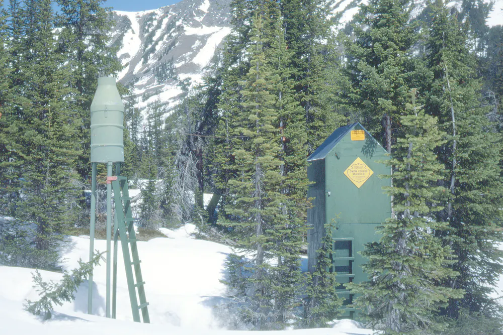
Snow survey sites, like the one seen here in Montana, can help scientists measure snowpack, but most sublimation happens above the treeline, a zone for which there is little data.USDA NRCS Montana/WikimediaCommons
Sublimation is mysterious
It is relatively easy to measure how much water is flowing through a river or in a lake. And using satellites and snow surveys, hydrologists can get decent estimates of how much snow is on a mountain range. Measuring evaporation, and especially sublimation, is much harder to do.
When scientists have been able to measure and estimate sublimation, they have measured moisture losses that range from a few percent to more than half of the total snowfall, depending on the climate and where you are. And even in one spot, sublimation can vary a lot year to year depending on snow and weather.
When moisture is lost into the atmosphere, it will fall to the surface as rain or snow eventually. But that could be on the other side of the Earth and is not helpful to drought-stricken areas.
Important knowledge
It is hard to say how important loss of moisture to the atmosphere is to the total water cycle in any given mountain range. Automated snow monitoring systems – especially at high elevations above the treeline – can help researchers better understand what is happening to the snow and the conditions that cause losses to the atmosphere.
The amount of water in rivers – and when that water appears – influences agriculture, ecosystems and how people live. When there is a water shortage, problems occur. With climate change leading to more droughts and variable weather, filling a knowledge gap of the water cycle like the one around sublimation is important.
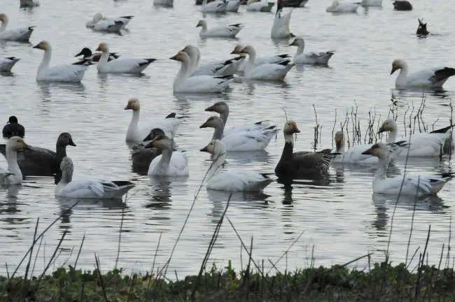
Geese at the Sacramento National Wildlife Refuge Complex. Photo courtesy of Tuleyome. NORTHERN CALIFORNIA — Located in California’s Central Valley, the Sacramento National Wildlife Refuge Complex is made up of six individual National Wildlife Refuges including Sacramento, Colusa, Delevan, Butte Sink, Sutter and a long stretch of the Sacramento River from Red Bluff south to Princeton.
The complex adds up to 10,819 acres and was originally established by Franklin D. Roosevelt on Feb. 27, 1937, as a Migratory Waterfowl Refuge.
Waterfowl using the Pacific Flyway to migrate currently and historically used the area as a winter refuge.
In the mid 1800s, when early settlers were trying to homestead in the Sacramento area, they were met with some inconveniences.
It was hot and dry in the summer months and during the winter months the land became a marsh. In order to build their communities and grow food, they developed the Glenn-Colusa Irrigation District to divert water from the overflowing Sacramento River and direct it where it could be used for farming.
As a result of this and other irrigation projects in California, the acreage of wetlands available to migrating waterfowl was decreased by 90%.
In the Sacramento region alone, wetland acreage dwindled from 5 million acres to less than 320,000 acres.
Although acres of natural wetlands were converted to agriculture, rice farming practices still provided food for the hungry and tired migrating birds.
In fact, the throngs of hungry birds could eat up a devastating 40 acres of rice crops in a single night. In response to the conversion of wetlands and the destruction of crops, the Sacramento National Wildlife Refuge Complex was created.
The establishment of the complex helped to: — manage wetlands specifically for wildlife and other plants and animals; — deter rice crop depredation; — create endangered species habitat; — provide recreational and environmental education/interpretation opportunities; — provide research opportunities.
As a result of rice crop devastation, a cooperative rice farming program was established but later failed. It was decided that all crops should be removed from the SNWR and replaced with managed wetlands.
As the water draws down in the spring, seed producing plants germinate and provide food for wintering waterfowl and other wildlife.
Today, the Sacramento National Wildlife Refuge is home to over 400 species of plants, 300 species of birds and 500 different species of mammals, reptiles and amphibians.
The Sacramento NWR has the greatest concentration of waterfowl per acre in the entire world and comprises over 7,500 acres of managed wetlands supporting peak populations of 850,000 migrating waterfowl.
Other species of interest observed in the complex include bald eagles, red-tailed hawks, great blue herons, snowy egrets, just to name a few. It is an amazing experience to see such an array of birds in such a small area.
The NWR headquarters are located at the Sacramento NWR. Here you can learn more about the plants, birds and animals around you.
When it is open to the public, they have educational classes for children, youth and adults of all ages.
The California Junior Duck Stamp competition is a favorite program allowing youth a chance to create and compete in state and national duck stamp competitions.
The SNWR is practically in our backyard. I recommend visiting it to anyone who would like to get out and explore nature; you don’t even have to get out of your car.
Kevin Deacon is a lifelong Davis resident, an outdoor enthusiast and a recent graduate of Tuleyome’s California Naturalist Certification course. If you would like more information about the course, please email This email address is being protected from spambots. You need JavaScript enabled to view it.. Kristie Ehrhardt is Tuleyome’s Land Conservation and Stewardship Program Manager; email her at This email address is being protected from spambots. You need JavaScript enabled to view it..
Geese at the Sacramento National Wildlife Refuge Complex. Photo courtesy of Tuleyome.
LAKE COUNTY, Calif. — His wife’s experience with the COVID-19 virus has prompted Clearlake’s mayor to make an impassioned plea to city staff to get vaccinated.
As the Clearlake City Council meeting was winding down on Thursday night, Clearlake Mayor Dirk Slooten used his report to make the request of staff.
Slooten’s wife, Karen, recently contracted COVID-19 despite the fact that they both had been vaccinated against the virus, he said.
He explained that his wife has immune deficiency issues. Her doctor told her that had she not been vaccinated, he believed she would have died.
That spurred Dirk Slooten to begin talking to city staff and encouraging those who weren’t vaccinated to get the vaccine.
“Please do. It’s very near to my heart,” he said.
Slooten said at Thursday night’s meeting that he had been talking to City Manager Alan Flora and City Clerk/Administrative Services Director Melissa Swanson about how to help get more city employees vaccinated.
He said they would be sending out a memo to staff and that he wants to offer every city employee who has not been vaccinated yet but gets vaccinated by Sept. 1 a $100 “just to emphasize the necessity for getting vaccinated.”
Slooten added, “It’s important, very important to end the spread of this pandemic.”
If the city doesn’t cover the cost, Slooten said he will.
“If we hadn’t done it, I’d be a widower,” Slooten said of he and his wife getting vaccinated.
In a Friday interview with Lake County News, Slooten said he was finishing up the memo to staff and wife Karen was helping him look it over before sending it to Swanson to distribute to staff.
He said his wife had tested positive with a breakthrough infection after July 4.
She was not hospitalized, but Dirk Slooten said she’s not yet fully recovered. “She’s slowly getting better.”
Karen Slooten had pain in her lungs and shortness of breath, and horrible headaches. Her husband said she didn’t experience one of the notable symptoms, loss of smell.
Her doctor made it clear that being vaccinated prevented her from having a much worse case of the virus. “It really started hitting home. You wouldn't be around if you weren’t vaccinated,” Dirk Slooten said.
Also on Friday, he said they received word that one of his wife’s cousins, a reasonably healthy individual who wasn’t vaccinated, contracted the virus, was in the hospital and then released, only to die.
Dirk Slooten said city administrative staff can decide to cover the vaccination bonus without council action.
However, he reiterated that if the city doesn’t fund his proposal, he’ll pay for the bonuses for employees who get the shots himself in an effort to protect more people and limit the virus’ spread.
Email Elizabeth Larson at This email address is being protected from spambots. You need JavaScript enabled to view it.. Follow her on Twitter, @ERLarson, or Lake County News, @LakeCoNews.
What's up for August? Prime time for the Perseids, Jupiter and Saturn at “opposition,” and why the third moon of the season is kind of special.
August brings the best-known meteor shower of the year, the Perseids. This annual meeting shower happens each year as Earth crosses the debris trail of comet Swift-Tuttle. Most of these meteors are grains of dust up to the size of a pea and they create fabulous "shooting stars" as they burn up an Earth's atmosphere.
Although Perseids can be seen from mid-July through late August, the most likely time to see any meteors is a couple of days on either side of the peak.
This year the peak falls on the night of Aug. 11 and into the predawn hours of Aug. 12. (Think of that as "prime time" for the Perseids.)
Under really dark skies, you could see almost one per minute near the time of maximum activity. This year's peak night for the Perseids benefits from a moon that sets early in the evening, so it won't interfere with the faint meteors, but before it sets that evening, be sure to check out that gorgeous crescent moon in the west after sunset with brilliant planet Venus.
To enjoy the Perseid meteor shower, just find a safe, dark location away from bright city lights, lie down or recline with your feet facing roughly toward the north, and look up.
The meteors appear to radiate from around the constellation Perseus, but they can streak across the sky anywhere above you.
NASA also has a way for you to catch some Perseids online. NASA's Meteor Watch team plans a livestream overnight on Aug. 11. Visit http://go.nasa.gov/2021perseids for more details.
August is perhaps the best time this year to enjoy viewing Jupiter and Saturn, as both planets reach opposition this month.
“Opposition” is the term for when a planet is on the same side of the solar system as Earth and directly opposite from the Sun. It happens each year, as Earth loops around in its orbit, passing by the much slower-moving gas giant planets. Opposition is also near the time when Earth is closest to the planet, so this is when the planet tends to look its biggest and brightest.
Now, opposition does technically have a precise moment when the sun, Earth, and the planet line up, but in practice it's better to think of it as a period of time, usually about a month.
For Saturn, opposition takes place this year on Aug. 2 and for Jupiter, it's Aug. 19. For the latest close-up views and discoveries from Jupiter, follow NASA's Juno mission with NASA's solar system exploration website and social media.
As you're enjoying Jupiter and Saturn during August, watch as the increasingly full moon slides beneath the pair of planets over several days, from the 19th to the 22nd.
Plus, the full moon on Aug. 22 is what's known as a seasonal blue moon, as it's the third full moon out of four this season, where normally each season there are only three. This happens every two-and-a-half to three years or, as they say, “once in a blue moon.”
You can catch up on all of NASA's missions to explore the solar system and beyond at www.nasa.gov.
Preston Dyches works for NASA's Jet Propulsion Laboratory.
Bart Johnson, University of Oregon and David Hulse, University of Florida
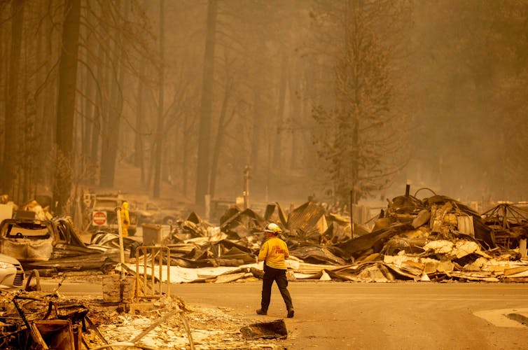
A wildfire burning in hot, dry mountain forest swept through the Gold Rush town of Greenville, California, on Aug. 4, reducing neighborhoods and the historic downtown to charred rubble. Hours earlier, the sheriff had warned Greenville’s remaining residents to get out immediately as strong, gusty winds drove the Dixie Fire toward town. At the same time, firefighters were also trying to protect two other communities – all not far from where the deadly Camp Fire destroyed the town of Paradise in 2018.
This kind of trauma is becoming familiar, from loss of homes to the obliteration of entire towns. Fear of what the future holds in a changing climate lends uncertainty to people’s daily lives. They want to know how to protect their homes, their families, their communities. But they also want to protect core values they cherish – good places to raise their children, freedom to choose their lifestyle, a sense of place in nature and belonging.
How can people prepare for a future that’s unlike anything their communities have ever experienced?
The emergence of extreme fires in recent years and the resulting devastation shows that communities need better means to anticipate mounting dangers, and underscores how settlement patterns, land management and lifestyles will have to change to prevent even larger catastrophes. Our research team of landscapearchitects, ecologists, social scientists and computer scientists has been exploring and testing strategies to help.
What might the future hold?
Because climate change is contributing to unprecedented extreme fire weather, we used simulation modeling to explore and test how forest management and rural development could reduce or amplify wildfire risks in coming decades.
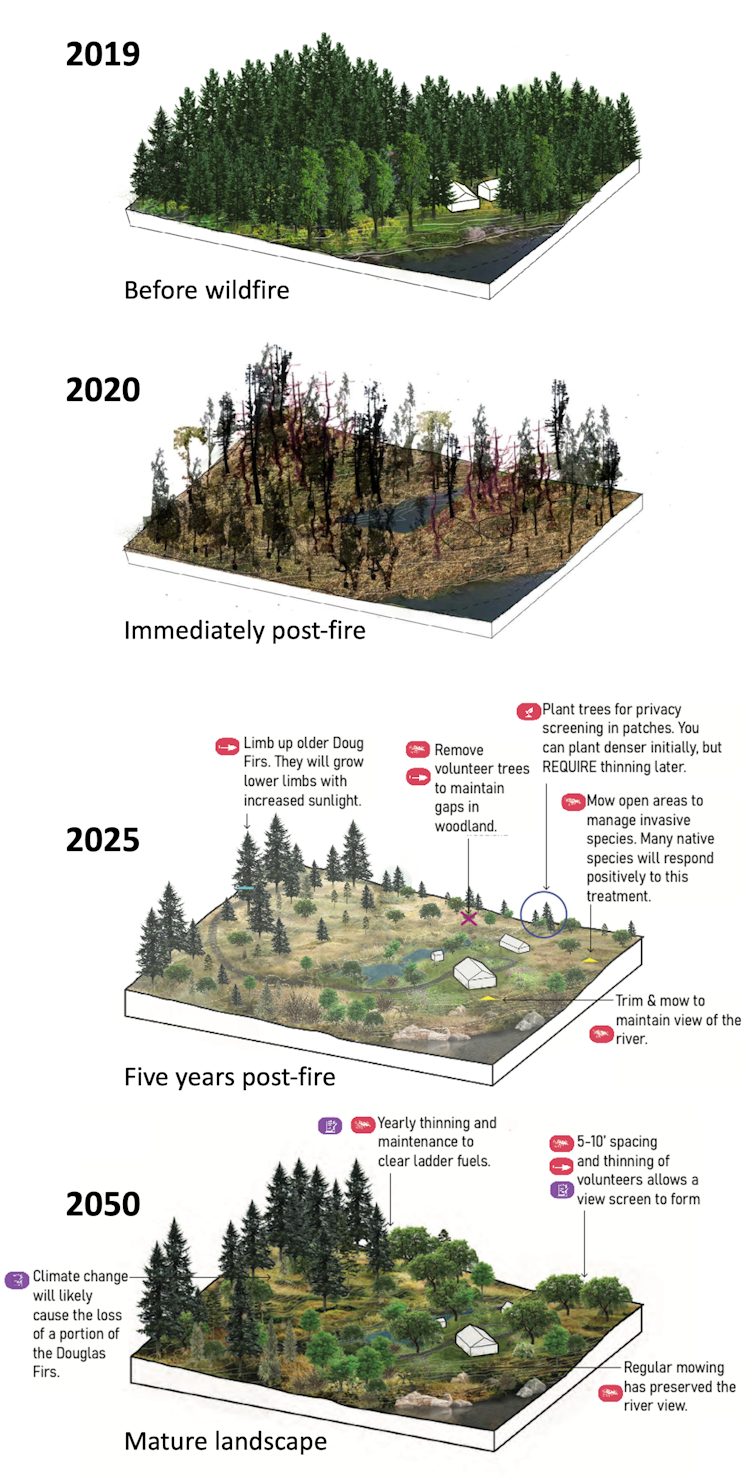
To do this, we created a computer version of the rural landscape around Eugene-Springfield, a midsize metropolitan area in Oregon’s Willamette Valley with a rapidly expanding population. Our simulations played out in carefully mapped representations of that landscape beginning in 2007, including its vegetation, property boundaries and the type of landowner managing each parcel, such as farmers, foresters or rural residents who moved to the countryside from the city.
For each of 50 simulated years, as climate models generated fire weather and altered the vegetation, each landowner chose actions such as removing hazardous fuels like small trees and underbrush, restoring fire-adapted ecosystems, growing crops, building homes or protecting homes with landscaping and building materials recommended by the National Fire Protection Association’s Firewise program.
Forest thinning (left) and grassland restoration can help reduce wildfire severity.Bart Johnson
Over time, the simulated landowners could respond to emerging threats while protecting valued crops, amenities, lifestyles and ecosystems.
We tested different strategies under two climate models in 600 simulated futures. Under one climate model, wildfire behavior remained much the same as in the recent past while the number of fires grew because of increased human ignitions as the population increased. Under the other, more extreme climate model, wildfires larger than any experienced in the Willamette Valley’s recent past could erupt without warning, threatening homes even as landowners’ vegetation management reduced the fires’ spread.
It turned out that those worst-case projections were dwarfed by the wildfires in 2020 just outside our study area.
Three lessons for surviving the future
Here are three key lessons we’re learning from our research on how people might reliably reduce their losses in a future that could bring more fires, unpredictable larger fires, or both.
1) Prepare for uncertainty: In a simulated world with extreme, unpredictable wildfires, 10 times more homes were threatened in our study area than in identical rural development and forest management scenarios under less extreme climate impacts. In our worst-case scenario – in which rural development expands without constraint and the forests aren’t thinned by people or allowed to burn naturally – over 30 times more homes were threatened than under conditions with less rural population growth and more management.
The good news was that when 30% of the burnable landscape was actively managed to reduce fire risk with forest-thinning techniques and grassland restoration, the threat to homes fell by nearly half in the world of extreme wildfires.
2) Choose treatments wisely: Reducing forest density by thinning out smaller trees and underbrush effectively reduced the spread and severity of fires in extreme fire weather. In fact, our results suggest these tactics become increasingly effective as fires grow larger and more intense.
In our study area, restoring imperiled native grasslands with scattered trees could do the best job of reducing risk to individual homes by creating “safe” places, where the fire can’t spread fast through the tree canopy and firefighters can battle it, under even extreme wildfire conditions. One such fire exploded out of nowhere under the less-extreme climate model, threatening over 900 homes. Two-thirds of homes in restored grasslands were protected by Firewise practices. Density thinning was only half as effective because of the difficulties of protecting homes in a forest. But the biggest challenge was that the high costs of thinning kept most forest landowners from maintaining treatments over time. As a result, high-severity fire consumed unmanaged forests, threatening 85% of homes there.
Grasslands pose a two-edged sword if not carefully managed – under extreme fire weather they could foster fast-spreading fire corridors that leave homes in nearby forests exposed to greater risk.
An animation shows how the same fire spreads in three potential future landscapes in three scenarios: with no management, thinning only and thinning accompanied by grassland restoration.
3) Manage rural development. Dealing with the often-divisive issue of where and how people build new homes is crucial when it comes to wildfire risk. Oregon is renowned for statewide policies that constrain urban sprawl.
When we tested scenarios with more relaxed rules, we found that adding many new rural homes increased the average risk per home. Under these relaxed policies, sites in less risky areas were quickly developed and housing shifted to steeper, forested terrain at greater risk of severe fires. That can compound risk by putting more homes in harm’s way and increasing the potential for vehicles and power lines to ignite fires.
An advantage of simulation modeling is that it allows scientists, policymakers and citizens to investigate things we can’t easily test in the real world. We can explore prospective solutions, identify new problems they create and address them and run the simulations again.
In the real world, there is only one chance to get it right. People need to be able to identify reliable, adaptive approaches that can be implemented in sufficient time and in the right places before catastrophes happen. As carpenters say, “Measure twice, cut once.”
So what should people in fire-prone areas do?
Western wildfires are getting more extreme, but in many cases landowners and communities may be able to dramatically reduce the damage.
Our worst-case scenario – high climate impacts, large numbers of new rural homes and no fuels management – led to an order of magnitude greater risk to homes in our study area over the next 50 years. But by consolidating new development in cities and clustered rural housing, the risk dropped by half. And combining compact development with management of burnable vegetation reduced it by nearly 75%.
University of Oregon landscape architecture students worked with landowners whose homes were destroyed in the 2020 Holiday Farm Fire to help them develop greater resilience to future wildfires.Cameron Dunstan and Eyrie Horton, CC BY-ND
LAKE COUNTY, Calif. — Public Health officials reported that Lake County’s COVID-19 case rate is continuing to climb and is nearly three times the state average, which is why they are urging people to get vaccinated, wear masks and practice social distancing.
For the period from June 12 to June 18, Lake County’s daily case rate was 0.7 per 100,000 and test positivity stood at 0.7%.
Universal masking in California ended June 15. Although unvaccinated individuals were still required to wear face coverings, many had a sense the pandemic was “over,” and relaxed their commitment to the precautions that had brought Lake County’s COVID-19 cases to low levels.
Then, in late June, Lake County documented its first cases of the Delta variant, a hyper-transmissible strain that has truly been game-changing.
Now, a month and a half post the June 12 to 18 low, the state is reporting Lake County’s Case Rate as 58 per 100,000, nearly three times the state average. Lake County’s test positivity is 17.4%, more than double the statewide rate.
Over the past month, Lake County has had the highest case rate statewide, however, on Friday, Del Norte topped Lake County with a case rate of 59 per 100,000, according to the California Department of Public Health.
Public Health said Friday that 15 Lake County residents are hospitalized due to COVID-19, with five of those individuals in the ICU. These numbers do not include those currently receiving hospital-based care outside of Lake County. No local ICU beds are available.
Public Health said the Delta variant is the type of strain they expected in winter, when vaccination efforts were in their infancy and people were questioning whether minor symptoms were COVID-19 or the common cold.
However, with 40% of those eligible (age 12+) and nearly half of all Lake County residents still unvaccinated, the virus has an opportunity to spread and mutate, Public Health reported.
As a result, Public Health said that during the month of July, unvaccinated individuals were six times more likely to become infected in Lake County.
Public Health said masking and maintaining physical distancing are key right now. If you visit high-foot-traffic areas where maintaining social distancing is difficult, or attend events with people from many households, the risk of COVID-19 is there.
With the Delta variant, aerosol spread is more common. Tiny, free-flowing virus particles that can linger in the air for minutes to hours are causing new infections.
The Lake County Board of Supervisors acted Tuesday to require universal masking in all county-operated facilities.
Public Health said California counties with case rates one-third as high as Lake County’s have imposed stronger mandates because face coverings work.
If you are concerned you may have been exposed, Public Health urges you to get tested.
Health officials also urge community members to get vaccinated, noting that COVID-19 vaccines have proved highly protective against severe illness and death.
Areas all around the country are reporting 90% of hospitalized patients are unvaccinated. Many people remain hesitant, some because of side effects that are less common than severe complications from COVID-19. If you have questions, please reach out to your treating doctor. If you want to get vaccinated, but are facing barriers, call 707-263-8174.
In its ongoing effort to understand COVID-19 transmission and improve outcomes in our communities, Lake County Public Health tracks demographic, geographic and clinical information about confirmed COVID-19 cases.
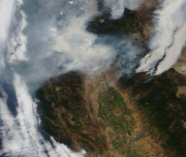
Wildland fire smoke in Northern California on Thursday, August 5, 2021. Clear Lake is the green object in the bottom third of the picture. Hours later, the skies over Lake County became smoky due to northwest winds, according to the National Weather Service. Photo courtesy of NASA. LAKE COUNTY, Calif. — The National Weather Service’s forecast says Lake County should expect more smoke and haze through part of the weekend.
Lake County’s blue summer skies began to turn a smoky hue on Thursday evening as smoke from fires to the north began making its way into the air basin.
The National Weather Service said northwest winds pushed smoke from the smoke from the fires more to the southeast on Thursday, bringing smoke to eastern Mendocino and Lake counties.
Widespread haze is forecast on Friday, with patchy smoke from Friday night through Saturday night, according to the forecast.
The skies are forecast to be clear from Sunday into next week.
Temperatures will hover in the high 90s during the day and the high 50s to low 60s at night through the coming week, the forecast said.
Email Elizabeth Larson at This email address is being protected from spambots. You need JavaScript enabled to view it.. Follow her on Twitter, @ERLarson, or Lake County News, @LakeCoNews.

 How to resolve AdBlock issue?


.jpg#/media/File:Matterhorn_(4448885336).jpg)
.jpg#/media/File:Snow_Survey72_(27281994099).jpg)