What's up for March? Venus climbs high while Jupiter dives sunward, and the little planet that shares its namesake with your breakfast cereal.
Venus and Jupiter began the month very close together in the evening sky, following their close conjunction on March 1.
They quickly went their separate ways, though.
Venus climbs higher in the sky each night for the next couple of months, while Jupiter dives after the Sun.
The giant planet appears lower in the sky each night through the month, making its exit as an evening object. It'll reappear in May, in the predawn sky, with Saturn.
On the 23rd and 24th, in the couple of hours after sunset, you'll find the Moon as a beautifully slim crescent hanging just below, and the next night above, blazing bright Venus. Then, on the 25th, the Moon continues upward in the sky, landing right next to the brilliant Pleiades star cluster that night.
With March bringing the arrival of spring in the Northern Hemisphere and fall in the Southern Hemisphere, it's a time for both planting or harvesting crops, depending on where you live. So it's perhaps a fitting time to try and spot the planet named for a mythical goddess of agriculture, grains, and fertile lands. (In addition to being the origin of the word "cereal.")
That's dwarf planet Ceres. This month it's at opposition, meaning it's directly on the opposite side of Earth from the Sun. This is when a planet is around its shortest distance from Earth, making this the best time to have a go at observing it when it's at its brightest.
Ceres is the largest object in the main asteroid belt between Mars and Jupiter. Still it's only about 600 miles wide — far smaller than our own Moon. Its dusty surface is peppered with impact craters, with bright salt deposits here and there, that hint at the possibility of slushy, briny ice beneath. In fact, NASA's Dawn spacecraft found that Ceres could be up to one-quarter water ice on the inside.
Now, Ceres is too faint to see with the unaided eye, so to locate it in the March sky, you'll need binoculars or a small telescope. Find the lion constellation Leo in the southeast after around 9 p.m.
The bright, bluish-white star Regulus (the lion's heart) should catch your eye first. Then look eastward about 25 degrees to find Denebola, which represents the lion's tail. From there Ceres should be 8 or 9 degrees farther east from Denebola. It appears as a faint, starlike point of light — which is why, when Ceres and objects like it were first discovered in the early 19th century, they were called "asteroids," which means "starlike."
Since 2006, Ceres has been classified as a dwarf planet — along with other diminutive worlds in our solar system including Pluto, Eris, Haumea, and Makemake. Wherever you land on the topic of "planet vs. dwarf planet" -status for worlds like Ceres and Pluto, what's really important to remember is that the way we think about different families of objects in our solar system has evolved over time, and likely will continue to evolve as we explore and learn more about them.
So here's hoping you try your hand at spotting Ceres as you explore the skies above your home planet this month.
Stay up to date with all of NASA's missions to explore the solar system and beyond at www.nasa.gov.
Preston Dyches works for NASA's Jet Propulsion Laboratory.
About one-third of Americans say they don’t look forward to these twice-yearly time changes. And nearly two-thirds would like to eliminate them completely, compared to 21% who aren’t sure and 16% who would like to keep moving their clocks back and forth.
But the effects go beyond simple inconvenience. Researchers are discovering that “springing ahead” each March is connected with serious negative health effects, including an uptick in heart attacks and teen sleep deprivation. In contrast, the fall transition back to standard time is not associated with these health effects, as my co-authors and I noted in a 2020 commentary.
I’ve studied the pros and cons of these twice-annual rituals for more than five years as a professor of neurology and pediatrics and the director of Vanderbilt University Medical Center’s sleep division. It’s become clear to me and many of my colleagues that the transition to daylight saving time each spring affects health immediately after the clock change and also for the nearly eight months that Americans remain on daylight saving time.
However, the two time shifts – jolting as they may be – are not equal. Standard time most closely approximates natural light, with the sun directly overhead at or near noon. In contrast, during daylight saving time from March until November, the clock change resulting from daylight saving time causes natural light to be present one hour later in the morning and one hour later in the evening according to clock time.
In 2023, clocks spring forward one hour at 2 a.m. on Sunday, March 12. They fall back at 2 a.m. on Sunday, Nov. 5.iam2mai/iStock via Getty Images Plus
The biggest advantage of daylight saving time is that it provides an extra hour of light in the late afternoon or evening, depending on time of year, for sports, shopping or eating outside. However, exposure to light later into the evening for almost eight months during daylight saving time comes at a price. This extended evening light delays the brain’s release of melatonin, the hormone that promotes drowsiness, which in turn interferes with sleep and causes us to sleep less overall.
Geography can also make a difference in how daylight saving time affects people. One study showed that people living on the western edge of a time zone, who get light later in the morning and later in the evening, got less sleep than their counterparts on the eastern edge of a time zone.
This study found that western-edge residents had higher rates of obesity, diabetes, heart disease and breast cancer, as well as lower per capita income and higher health care costs. Other research has found that rates of certain other cancers are higher on the western edge of a time zone.
Scientists believe that these health problems may result from a combination of chronic sleep deprivation and “circadian misalignment.” Circadian misalignment refers to a mismatch in timing between our biological rhythms and the outside world. In other words, the timing of daily work, school or sleep routines is based on the clock, rather than on the sun’s rise and set.
This video takes a deeper dive – all the way back to 1895 – into the history of daylight saving time.
The idea was that having extra light later into the afternoon would save energy by decreasing the need for electric lighting. This idea has since been proved largely inaccurate, as heating needs may increase in the morning in the winter, while air conditioning needs can also increase in the late afternoon in the summer.
After World War II, designating the start and end dates for daylight saving time fell to state governments. Because this created many railroad scheduling and safety problems, however, Congress passed the Uniform Time Act in 1966. This law set the nationwide dates of daylight saving time from the last Sunday in April until the last Sunday in October. In 2007, Congress amended the act to expand the period in which daylight saving time is in effect from the second Sunday in March to the first Sunday in November – dates that remain in effect today.
The Uniform Time Act allows states and territories to opt out of daylight saving time, however. Arizona and Hawaii are on permanent standard time, along with Puerto Rico, the U.S. Virgin Islands, Northern Mariana Islands, Guam and American Samoa.
Now, many other states are considering whether to stop falling back and springing ahead. Several U.S. states have legislation and resolutions under consideration to support permanent standard time, while many others have been or are considering permanent daylight saving time. Legislation and resolutions for permanent standard time have increased from 15% in 2021 to 31% in 2023.
The spike in activity among states seeking to break from these twice-yearly changes reflects how more people are recognizing the downsides of this practice. Now, it’s up to legislators to decide whether we end the time shift altogether, and to choose permanent standard or daylight saving time.
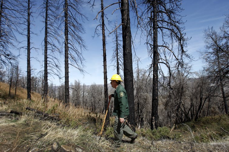
Wildfires and severe drought are killing trees at an alarming rate across the West, and forests are struggling to recover as the planet warms. However, new research shows there are ways to improve forests’ chances of recovery – by altering how wildfires burn.
In a new study, we teamed up with over 50 other fire ecologists to examine how forests have recovered – or haven’t – in over 10,000 locations after 334 wildfires.
Together, these sites offer an unprecedented look at how forests respond to wildfires and global warming.
Our results are sobering. We found that conifer tree seedlings, such as Douglas-fir and ponderosa pine, are increasingly stressed by high temperatures and dry conditions in sites recovering from wildfires. In some sites, our team didn’t find any seedlings at all. That’s worrying, because whether forests recover after a wildfire depends in large part on whether new seedlings can establish themselves and grow.
However, our team also found that if wildfires burn less intensely, forests will have a better shot at regrowing. Our study, published March 6, 2023, highlights how proactive efforts that modify how wildfires burn can help buffer seedlings from some of the biggest stressors of global warming.
Drag the map’s slider bar from the center to compare how forest recovery is likely to differ between low-severity fires and high-severity fires in the future. K. Davis et al, 2023.
Typically, forests have regrown after wildfires, thanks to an amazing set of traits that trees possess. Lodgepole pine, for example, stores thousands of seeds in closed cones sealed with resin, that only open in the presence of high heat from flames, triggering abundant regrowth. Other tree species, like ponderosa pine, have thick bark that helps them survive low-intensity wildfires.
Intense or very large “megafires” can overwhelm those traits, though. Most conifer tree species in the West depend on seeds from surviving trees to jump-start recovery following wildfire. So when intense wildfires kill most of the trees, entire expanses of forest can be lost.
Even if some trees do survive a wildfire and can provide seeds, seedlings require favorable climate conditions to establish and grow. Unlike adult trees with deep root systems, seedlings have short roots that only reach water in the top layer of soil. Seedlings are also more sensitive to summer temperatures because hot temperatures can actually kill their live cells.
Seedlings struggling to establish after wildfires
Hotter and drier conditions due to global warming are leading to more area burning. Global warming is also interacting with over a century of wildfire suppression and restrictions on Indigenous fire stewardship, which has left denser forests and more underbrush as fuel. And that is leading tomore severe wildfires.
It’s also becoming harder for seedlings to establish and grow after wildfires.
We found that from 1981 to 2000, 95% of our study region had climate conditions suitable for seedlings to establish and grow after wildfires. Fast forward to 2050 and this decreases to 74%, even under modest warming where global average temperatures increase by around 2 degrees Fahrenheit (1.1 Celsius).
How these changes unfold varies across the West. Today, seedlings are least likely to establish and grow after wildfires in the Southwest and California. However, the wetter and cooler regions of the northern Rocky Mountains and Pacific Northwest still support seedling establishment and growth.
Survivor trees are crucial for sheltering seedlings
By studying both how severely wildfires burn – for example, how many trees are killed – and how climate conditions after a wildfire affect new seedlings, our team found a surprising and hopeful result.
Even when summers are hotter and drier after a wildfire than in the past, just having trees around that survived a fire helps new seedlings establish and grow.
Besides providing seeds, surviving trees reduce temperatures on the ground, where it matters most to seedlings. In some cases, temperatures can be 4 to 5 degrees Fahrenheit cooler (2.2 to 2.8 C) around surviving trees, giving seedlings the edge needed to germinate and survive.
In our study, projections of future forests varied dramatically, depending on how many trees we assumed survived future wildfires.
Altering how wildfires burn can boost recovery
This means there is an opportunity to help offset some climate-driven declines in tree recovery – by reducing the number of trees killed in wildfires.
Reversing global warming is a long-term challenge for society, and some near-term impacts are already irreversible. But reducing the number of trees killed in wildfires can help maintain future forests. In regions where seedlings are already struggling after wildfire, such actions are needed sooner rather than later.
Science supports the use of a number of tools, or forest treatments, that can help decrease the number of trees killed by wildfires.
Controlled burning with forest thinning or cultural burning by local Indigenous groups removes small trees and brush. That leads to fewer trees killed in subsequent fires, especially in forests that historically burned frequently. In high-elevation forests that historically experienced less frequent but more severe wildfires, planting trees after wildfires can help jump-start forest recovery.
Expanding the use of wildfires and controlled burning as management tools is challenging, but the evidence suggests it may be one of the most effective and economical ways to reduce the number of trees killed by future wildfires.
There are clear ways to lessen the impacts of global warming and wildfires on seedlings and future forests. But in some areas, even as we work to reverse global warming, the window of opportunity is short. In these areas, forest treatments that modify wildfire or jump-start recovery will be most effective in the next few decades, setting up seedlings to better withstand near-term warming.
NORTH COAST, Calif. — Caltrans announced on Thursday that it is awarding more than $225 million for local projects designed to reduce traffic deaths and serious injuries on city and county roads, with several Lake County projects to be funded.
The funding is provided through the federal Highway Safety Improvement Program, or HSIP.
“Safety is always Caltrans’ top priority,” said Caltrans Director Tony Tavares. “These projects will enhance systemwide safety features, including enhancing safety for people who walk and bike, and move us closer to our vision of reaching zero fatalities and serious injuries on roadways throughout the state by 2050.”
In Lake County, three projects will be funded:
— Pedestrian crossing improvements including installing solar powered rectangular rapid flashing beacons and LED enhanced crosswalk signs, speed tables, lighting and pavement markings at 12 locations including, Upper Lake, North Lakeport, Lucerne, Lower Lake, Hidden Valley, Middletown and Kelseyville.
— Install solar powered dynamic speed warning signs at 22 locations including Soda Bay Road, Butts Canyon Road, Nice-Lucerne Cutoff Road, Lakeshore Boulevard, Morgan Valley Road, Sulphur Bank Drive, Bottle Rock Road, Scotts Valley Road, New Long Valley Road, Seigler Canyon Road and Spruce Grove Road.
— Robinson Rancheria street sign and guardrail replacement including new street signage with regulatory, warning and information. Upgrades to guardrails on Acorn Drive and crosswalk improvements on Pomo Way.
Other city and county road projects around the North Coast approved for funding in Caltrans District 1 include the following.
Eureka: Install LED stop signs, dynamic speed warning signs, curb extensions, rectangular rapid flashing beacons for pedestrians and sidewalks on Buhne Street between Fairfield and Dean streets.
Humboldt County: Guardrail repair and replacement at various locations on roadways and bridges.
Humboldt County: In Willow Creek, install a pedestrian activated flashing beacon crosswalk at the intersection of County Club Road and Terrance Road and a warning flashing sign on Country Club Road.
Humboldt County: Install fog lines on rural roads in Humboldt County that are utilized by the Hoopa Valley, Karuk and Yurok Tribes.
Crescent City: Pedestrian crossing improvement projects at various locations, including sidewalks with ADA curb ramps, rectangular rapid flashing beacons, road signs, and updated pavement markings.
Ukiah: Traffic signal improvements along with signal re-timing and provide protected left-turn phases at various intersections of State Street, Perkins Street at South Orchard Avenue, East Gobbi Street at South Orchard Avenue and Airport Park Boulevard at Talmage Road.
Willits: Install and upgrade regulatory warning signs, new dynamic speed warning signs and center and edge lines on nine roadway segments including portions of North Main Street, Sherwood Road, East Commercial Street, McKinley Street, East San Francisco Avenue and Hazel Street.
Willits: Pedestrian safety improvements including upgrades to signal hardware, install and upgrade signs and crosswalks and pavement markings, Accessible Pedestrian Signal buttons and upgrade controllers and ped signal head mounts along Main St at East San Francisco Street, West Valley Road and Commercial Street.
Mendocino County: Upgrades and replaces existing guardrails and end treatments along roadway segments on East Side Potter Valley Road, Point Cabrillo Drive, Babcock Lane, Primrose Drive and Comptche-Ukiah Road.
Mendocino County: Installation of advance curve warning signs, pedestrian sidewalks, pathways and crossing improvements at Branscomb Road, Kenny Creek Road, Eastside Calpella Road/Marina Drive-Route 20 on/off ramp, Comptche Ukiah Road/Route 1-Mendocino Headlands State Park, Mountain View Road between Manchester and Boonville, Crawford Road, Foothill Blvd, and South State Street, Laws Avenue and Beacon Lane.
Mendocino County: Installation and upgrade of regulatory and warning signs with fluorescent sheeting and the installation of curve signs on horizontal curves, delineators, reflectors, and object markers on roadway segments along Branscomb Road, Eastside Calpella Road, North and South State Street, Sherwood Road, Comptche Ukiah Road, Simpson Lane, Vichy Springs Road, Valley Road, Mountain View Road, Pudding Creek Road, Eel River Road and Henderson Lane.
Fort Bragg: Install and upgrade larger stop signs along with intersection warning and regulatory signs, and upgrade pedestrian crossings improvements with enhanced safety features including rectangular rapid flashing beacons at Route 20 at Boatyard Drive, Route 1 at Pine Street, Pudding Creek, at Noyo Point/Harbor and Harold at Oak.
Fort Bragg: Pedestrian safety improvements including high visibility crosswalks, bulb-outs, warning signs and ADA curb ramps at nine intersections and connecting segments on Harold Street between Fir Street and Maple Street.
"While Caltrans continues to prioritize safety and sustainability on state highways, the Department also recognizes the importance of the local roads connected to those highways," said Caltrans District 1 Director Matt Brady. "We're excited to serve a role in helping to fund these improvements for counties and incorporated areas in Del Norte, Humboldt, Mendocino and Lake counties."
A total of 282 projects from 155 local agencies will receive HSIP funds for safety enhancements that include pedestrian crossing enhancements, bike safety improvements and new traffic signals, roundabouts, turn lanes, rumble strips and guardrails. Caltrans awards these grants every other year to cities, counties and tribal governments.
Caltrans is using the Safe System approach — which emphasizes multiple layers of protection, including safer road designs — to achieve its goal of reducing to zero the number of fatalities and serious injuries on state roadways by 2050.
Caltrans’ adoption of the Safe System approach builds on its ongoing work to embed safety in the state’s transportation system, and for that reason all transportation projects the department funds or oversees now must include “complete street” features that provide safe and accessible options for people walking, biking and taking transit.
More information on the program is available at Caltrans’ HSIP page, including a full list of approved projects.
A site plan for the Lakeport Courthouse. Image courtesy of the city of Lakeport.
LAKE COUNTY, Calif. — With the construction of Lakeport’s new courthouse set to start early next year, the Lakeport City Council held a discussion on Tuesday about possible traffic improvements to facilitate the higher traffic volumes expected in the project area.
The 45,300 square foot courthouse will be built on a five-acre site at 675 Lakeport Blvd. The cost is $73.1 million.
The Judicial Council of California reported that the project is now in the design-build phase, with construction expected to begin in February 2024 and to be completed in October 2025.
City Manager Kevin Ingram updated the council on the courthouse project and asked for direction on which traffic improvement options to take in Lakeport Boulevard.
Those improvements will be focused mainly on the area around the intersection with Larrecou Lane, which also is an access street to the Lakeport Senior Center and the city’s corporation yard.
Ingram said the main access to the courthouse site is a private driveway from the top of the hill along the eastern boundary of the property to Lakeport Boulevard near the intersection with Larrecou Lane.
“That was not originally the city’s preference” for the site access, but Ingram said that’s the direction the state’s studies are taking them.
Initially, the city wanted the Judicial Council to consider changing the access to the west side of the property, which would go around the county-owned agriculture building. However, he said the state has not been open to that option.
Now, the state is picking up the pace on the courthouse project, and the state’s traffic studies are showing minimal impact on traffic. Over the years, Ingram said the city has expressed its dissatisfaction with those findings.
With the state telling the city that it only has a small amount of money for roadway improvements, Ingram said the city has looked at the Lakeport Boulevard corridor and developed four options.
The first option, which Ingram said city staff didn’t support, is a traffic signal at Lakeport Boulevard at Larrecou Lane.
Ingram said there are no stoplights in Lakeport now, explaining they require maintenance estimated at $150,000 to keep them calibrated.
In addition to that ongoing cost that the city would have to absorb, Ingram said a traffic signal would be obtrusive to the corridor and its businesses — which include two grocery stores — especially on the east side.
The second option, and a less obtrusive one, is a small roundabout at the Lakeport Boulevard and Larrecou Lane intersection, Ingram said.
Ingram said the main problem with the roundabout option is expense due to acquiring the right of way. As a result, it’s likely to exceed the $500,000 for intersection improvements the Judicial Council has tentatively offered.
The third option is a two-way stop, with controlled access. Ingram said a new stop sign would be placed at the bottom of the courthouse driveway, across from the existing stop sign on Larrecou.
Ingram said that option likely would require some geometric redesign of Lakeport Boulevard. It would need a deceleration lane and a dedicated turn lane to turn into the site. A challenge would be pedestrian access, with city staff having discussed a lighted crosswalk.
The fourth option is a four-way stop. “That would certainly meet the needs when the court is in session,” said Ingram, but it would stop traffic along that entire traffic corridor around the clock, seven days a week.
Ingram said the third and fourth options could fit into the state’s $500,000 proposed budget, while the city would have to fund the traffic signal and roundabout options.
Councilman Kenny Parlet raised an issue with why the city should pick up the entire tab for the road improvements, since it’s a county courthouse. Ingram said it was a valid point, and that the county hasn’t yet been asked to contribute.
Councilman Michael Froio said they don’t want to see the courthouse leave the city. He said the city needed to try to plan for the future and determine the best ingress and egress, as the state is determined to build the courthouse in that location.
Councilmember Kim Costa pointed out the potential traffic challenges with vehicles coming off the overpass a block away.
Mayor Stacey Mattina said the additional traffic would mean that left hand turns to get out of store parking lots would be very difficult, forcing vehicles to turn right toward Main Street.
Froio pointed to the “Lakeport Hub” project, consisting of a new hotel, stores, restaurants and a gas station, that’s proposed to be built at 1842 Todd Road.
With all of that new development going on in the area and impacting traffic, “This thing is looking like a mess,” Froio said.
Ingram said there are positive aspects for traffic flow by having a roundabout at the intersection with Lakeport Boulevard and Bevins Street
He said he believes the court is underestimating the amount of money that will be required to dig into the hill to do the deceleration lane for the courthouse driveway.
While he said the Bevins Street and Lakeport Boulevard intersection is a critical piece for developing the traffic corridor, the state has made it clear that it’s off the table in connection to the courthouse project.
Costa moved to direct city staff to work with a traffic engineering consultant to develop preliminary design and detailed cost estimates for the two options the council favored following discussion — a roundabout and a two-way stop.
Parlet seconded and the council voted 5-0.
Ingram said city staff would get to work on that process and return to the council with options to review in a few months.
On Tuesday the council also welcomed new Community Development Department Administrative Specialist Mel Olea.
An MIT graduate who grew up in Lake County and has worked in the Bay Area, Olea told the council, “I’m really happy to be back to where I have roots.”
He said his family and friends are here, “And now my work family's here.”
Mattina quipped that Parlet nearly fell out of his seat when he heard Olea had attended MIT.
In other business on Tuesday, the council approved setting a public hearing next month for the purpose of certifying a mitigated negative declaration with a mitigation monitoring and reporting program, adopting a general plan amendment and zone change to revise the zoning associated with the Martin Street Phase III Residential Project.
That 40-unit project will be built by AMG & Associates LLC at 519 S. Smith St., next to the Phase I and II of the Martin Street Apartments, also built by AMG.
Council members also approved authorizing Ingram to execute the professional services agreement with Community Development Services for federal grant business financial assistance program services, and conditionally awarded a construction contract to James Day Construction Inc. dba Coastal Mountain Electric for the Silveira Community Center Electrical and HVAC Project.
Email Elizabeth Larson at This email address is being protected from spambots. You need JavaScript enabled to view it.. Follow her on Twitter, @ERLarson, or Lake County News, @LakeCoNews.
Brad Rasmussen and his dog, Remi. Courtesy photo. LAKE COUNTY, Calif. — Lakeport’s police chief on Tuesday officially threw his hat into the ring to pursue another local job — that of county supervisor.
Chief Brad Rasmussen said he plans to run for the District 4 supervisor position in the 2024 election.
A longtime Lake County resident, Rasmussen, 53, said he’s excited about the prospect of pursuing the supervisor’s job, which — if he won — he would take over at the start of 2025, after retiring.
Because of the presidential primary, the election will come sooner than in most years. Super Tuesday primaries in California fall in March, not June.
That means the election is just a year away — March 5.
He’ll challenge Supervisor Michael Green, appointed in October by Gov. Gavin Newsom to replace Tina Scott, who stepped down in July to take a job with the Lakeport Unified School District.
“I was surprised but also pleased to hear of Brad Rasmussen’s decision to run for District 4 supervisor in 2024,” Green said in a statement released on Lake County News on Tuesday evening. “I was privileged to work with Brad while serving on the Lakeport City Council, and his decades-long commitment to public safety and community-oriented policing speaks for itself. Suffice to say he will be a strong supervisorial candidate in the March 5, 2024, primary election.”
Green’s statement continued, “Brad’s announcement naturally raises questions about my own plans, but I’m not going to answer such questions on short notice. To my knowledge, the candidate filing period will not open for six months or more, and it’s not only possible but probable that other highly qualified candidates may enter the race. In particular, I want to encourage women, LGBTQ, LatinX and people of color to consider running for county office. There is still plenty of time to nominate a slate of strong, diverse candidates so District 4 voters have a real choice when electing their next supervisor.“
One other candidate already has confirmed to Lake County News that he will also enter the race.
Scott Barnett, who serves on the Lakeport Planning Commission, said Tuesday he will run for the supervisorial seat.
Barnett also had applied to the Governor’s Office for the District 4 seat last year but said the state didn’t interview him for the office and didn’t even acknowledge his application. Other applicants reported the same issues with the governor’s appointment process.
He said he saw Rasmussen’s Facebook announcement “and I'm even more motivated to run.”
Rasmussen said he’s been considering a run for supervisor for “quite a few months.”
The first person he talked to about it was wife, Karyn, to get her support.
They have two grown daughters, both of whom grew up in Lakeport and went to Lakeport schools: Stephanie, who is a doctor who graduated with honors in June 2022 from the University of California, Davis, School of Medicine, and Savannah, who received her Master of Science in behavioral psychology from Pepperdine University in May 2022 and is a Board Certified Behavior Analyst.
Brad Rasmussen said he has so far not set a retirement date but that it won’t be before the March 2024 primary.
He said any campaigning will take place well outside of work hours.
“I’m 100% committed to my job,” said Rasmussen. “I’m going to do my job like I always have.”
He hasn’t given the city of Lakeport a letter announcing his retirement, although he has spoken to City Manager Kevin Ingram about his plans to run for supervisor.
The announcement was not mentioned during the Lakeport City Council’s Tuesday evening meeting.
When he does set a retirement date, Rasmussen said he will give the city plenty of time to find his successor.
By the time he expects to retire next year, he will have served for 34 years with the Lakeport Police Department. He’s been chief since May of 2011.
As for his reasons for running for supervisor, Rasmussen said, “I’ve had a great career in police work but I’ve been in here a long time.”
He said he wants to transition to something else but also wants to continue to serve the community in a different way.
Rasmussen said he can use his skills and knowledge to benefit District 4 and the rest of the county.
What’s been the reaction to his announcement?
“So far, everything I’ve gotten has been positive reaction and support,” he said.
Those congratulating him on his Facebook announcement included retired Sheriff Brian Martin, Chief Probation Officer Wendy Mondfrans and Greg Folsom, Clearlake’s former city manager who now is city manager of Suisun City.
By seeking to hold elected office, Rasmussen will follow in the footsteps of another Lakeport Police chief who also was his mentor — Tom Engstrom.
Engstrom, who retired in 2005 after 11 years at top cop in Lakeport, served one term on the Lakeport City Council from 2010 to 2014.
Rasmussen’s late father-in-law, Arlin Pischke, also held elected office, serving on the Lakeport City Council from 1982 to 1990, serving twice as Lakeport’s mayor.
In 1984 Pischke ran for the District 4 supervisorial seat amidst a large field but lost to Karan Mackey, who held the seat for 16 years.
Rasmussen’s Facebook post from Tuesday morning is published below in its entirety.
Dear Fellow Citizens of District 4 in Lake County, CA,
I am writing to announce my intent to run for the position of District 4 Supervisor in the 2024 election. I am excited about the opportunity to serve my community and represent the interests of the residents of District 4.
As a longtime resident of Lake County, I have a deep commitment to our community and its future. I believe that my experience, qualifications, and dedication make me the ideal candidate for this important role.
Over the years, I have worked tirelessly to improve our community and enhance the quality of life for all residents. In addition to over three decades in local government I have served on various local organizations and nonprofit groups including Kiwanis and Lions Clubs.
If elected as your District 4 Supervisor, I will bring this same level of commitment and dedication to the job. My top priorities will include promoting economic growth and development, protecting our natural resources, improving our schools, and ensuring that our local government is transparent and accountable to the people it serves.
I believe that by working together, we can achieve great things for our community. I am committed to listening to your concerns, representing your interests, and working hard to make District 4 an even better place to live, work, and raise a family.
I am honored to currently work as Lakeport’s Chief of Police. As I near retirement, this position provides the perfect opportunity to continue to serve our community.
I hope to earn your support in the upcoming election. Thank you to my family and community members who have encouraged me to run.
Sincerely, Brad Rasmussen
Email Elizabeth Larson at This email address is being protected from spambots. You need JavaScript enabled to view it.. Follow her on Twitter, @ERLarson, or Lake County News, @LakeCoNews.
LAKE COUNTY, Calif. — The National Weather Service has placed Lake County under a flood watch due to more rain in the forecast.
The flood watch will remain in effect until 10 p.m. Friday.
National Weather Service observation stations showed that more than 2 inches of rain fell in parts of Lake County on Thursday.
Heavy rain fell late Thursday night in areas including the Northshore.
Another inch and a half of rain could fall through Sunday night, the forecast said, and still more rain is predicted through next weekend.
Windy conditions also are in the forecast through Sunday, with gusts of up to 30 miles per hour.
Daytime conditions this week see temperatures topping out in the low 50s, with nighttime temperatures into the high 30s.
Email Elizabeth Larson at This email address is being protected from spambots. You need JavaScript enabled to view it.. Follow her on Twitter, @ERLarson, or Lake County News, @LakeCoNews.
With a series of storms forecasted to continue through mid-March, including an atmospheric river event later this week, Gov. Gavin Newsom on Wednesday proclaimed a state of emergency to support storm response and relief efforts in 21 additional counties.
Those counties are Butte, El Dorado, Fresno, Humboldt, Imperial, Inyo, Lake, Mendocino, Merced, Monterey, Napa, Placer, Plumas, Sacramento, San Francisco, San Mateo, Santa Clara, Santa Cruz, Stanislaus, Tuolumne and Yuba.
The governor last week proclaimed a state of emergency in 13 counties due to storms, and activated the California Guard and State Operations Center to bring state support to county-led emergency response efforts and coordinate mutual aid from neighboring jurisdictions.
“The state is working around the clock with local partners to deploy life-saving equipment and first responders to communities across California,” said Gov. Newsom. “With more dangerous storms on the horizon, we’ll continue to mobilize every available resource to protect Californians.”
The state has significant staffing and equipment resources from the Governor’s Office of Emergency Services, or Cal OES, along with Caltrans, the California Highway Patrol, Cal Fire and the California National Guard on the ground in impacted areas.
Cal Fire and partner agencies have 43 crews active statewide, 12 of which are committed to the San Bernardino storm incident, as well as two helicopters, two dozers and an Incident Management Team, among other resources.
The California Guard is pre-positioning high water vehicles in preparation for flood response operations.
Caltrans has mobilized more than 4,000 crew members to hundreds of incidents statewide, working 24/7 in shifts.
In San Bernardino County, more than 57 Caltrans employees operating 40 high-powered pieces of equipment, including snowplows, graders, loaders and dump trucks, have removed more than 12.6 million cubic yards of snow off state highways as of March 8, which equates to more than 3,800 Olympic-size swimming pools.
CHP is increasing resources in targeted areas to help address storm-related needs – including ensuring full staffing for air operation missions, ready to deploy as needed.
Cal OES has coordinated with the Department of Developmental Services to open six shelters in the counties of San Bernardino, Stanislaus, Madera, Butte and Nevada, and has facilitated food donations through the California Grocers Association to provide meal kits in San Bernardino County.
Visit CalAlerts.org to sign up for local wireless emergency alerts and QuickMap to check road conditions in your area.
MIDDLETOWN, Calif. — The Middletown Area Town Hall this week will meet to get updates from county staff, discuss a letter in response to a Cal Fire map and a support letter for a local group’s wildfire prevention grant application.
MATH will meet at 7 p.m. Thursday, March 9, in the Middletown Community Meeting Room/Library at 21256 Washington St., Middletown. The meeting is open to the public.
To join the meeting via Zoom click on this link; the meeting ID is 331 855 4843. Call in at 669-900-6833.
On the agenda is a presentation by county Chief Climate Resiliency Officer Terre Logsdon, who will give a brief presentation about the Office of Climate Resiliency and get feedback on a survey.
The group also will host Andrew Amelung, Cannabis Task Force Committee Program manager for the Lake County Community Development Department. Amelung will provide a brief update on the progress of the Cannabis Task Force meetings.
Also on Thursday, MATH will consider a proposed letter to Cal Fire in response to the proposed “State Responsibility Area Fire Hazard Severity Zones.”
MATH also has been asked to consider a support letter for Heart Consciousness Church, also known as Harbin Hot Springs, in its time sensitive application for a wildfire prevention grant.
In other business, MATH will have a Brown Act training.
The MATH Board includes Chair Monica Rosenthal, Vice Chair Todd Fiora, Secretary Ken Gonzalez, and alternates Julia Bono and Tom Darms.
MATH — established by resolution of the Lake County Board of Supervisors on Dec. 12, 2006 — is a municipal advisory council serving the residents of Anderson Springs, Cobb, Coyote Valley (including Hidden Valley Lake), Long Valley and Middletown.
For more information email This email address is being protected from spambots. You need JavaScript enabled to view it..
Email Elizabeth Larson at This email address is being protected from spambots. You need JavaScript enabled to view it.. Follow her on Twitter, @ERLarson, or Lake County News, @LakeCoNews.
As another atmospheric river descends on California, Gov. Gavin Newsom on Thursday requested a presidential emergency declaration to authorize federal assistance supporting the state and local response to the severe storms impacting much of the state.
With storms forecasted to continue through mid-March, the governor on Wednesday proclaimed a state of emergency in 21 counties — including Lake — to support disaster response and relief efforts, following the state of emergency he proclaimed in an initial 13 counties earlier this month.
“California is deploying every tool we have to protect communities from the relentless and deadly storms battering our state,” said Gov. Newsom. “In these dangerous and challenging conditions, it is crucial that Californians remain vigilant and follow all guidance from local emergency responders.”
If approved, the emergency declaration would enable impacted counties to immediately access direct federal assistance to help protect public safety and property.
The request for direct federal assistance includes generators, road clearance equipment and potential sheltering and mass care assistance.
California is mobilizing personnel and resources to storm-impacted communities throughout the state.
The following resources are being deployed.
Cal Fire and partner agencies:
• 43 crews active statewide, 12 of which are committed to the San Bernardino storm incident (includes crews from California National Guard, California Conservation Corps, and California Department of Corrections and Rehabilitation). • Two helicopters, two dozers and an incident management team, among other resources. California National Guard. • The California National Guard is pre-positioning high water vehicles and aircraft in preparation for flood response operations.
California Department of Transportation:
• Mobilized more than 4,000 crew members to hundreds of incidents statewide, working 24/7 in shifts. • In San Bernardino County, more than 57 Caltrans employees operating 40 high-powered pieces of equipment, including snowplows, graders, loaders and dump trucks, have removed more than 12.6 million cubic yards of snow off state highways as of March 8, which equates to more than 3,800 Olympic-size swimming pools.
California Highway Patrol:
• Increasing resources in targeted areas to help address storm-related needs – including ensuring full staffing for air operation missions, ready to deploy as needed. • CHP and Caltrans escorts have been deployed to ensure the safe delivery of food and fuel to the Big Bear and west mountain communities.
Cal OES and partner agencies:
• Opened 8 shelters in the counties of San Bernardino, Stanislaus, Madera, Merced, Fresno, Butte and Nevada, and facilitated food donations through the California Grocers Association to provide meal kits in San Bernardino County. • Cal OES has sent 120 operators and over 60 pieces of heavy-duty snow removal equipment to dig out the snow-locked communities of San Bernardino. These resources are removing massive amounts of snow from public roads and other sites to help residents get access to needed supplies. • Prepositioned 20 swiftwater rescue and urban search and rescue teams, more than 50 fire engines, and over 60 personnel to provide aid to communities impacted by the extreme weather.
Safety tips for Californians
Emergency alerts
Californians can dial 2-1-1 or 3-1-1 to get help or ask questions. If you have a critical emergency, call 9-1-1.
Stay informed by signing up for emergency alerts including warnings and evacuation notices. Go to CalAlerts.org to sign up to receive alerts from your county officials.
Driving and road closures
Avoid non-essential travel during the peak of the storm through Saturday. If you must drive, download the QuickMap app or visit QuickMap.dot.ca.gov to learn up-to-the-minute information on road conditions, traffic, closures, chain control and more.
Power outages
Take inventory of the items you need that rely on electricity. Plan for batteries and other alternative power sources to meet your needs if the power goes out such as a portable charger or power bank. Have flashlights for every household member. Determine whether your home phone will work in a power outage and how long battery backup will last.
Flood risk
If you are under a flood warning:
• Find safe shelter right away. • Do not walk, swim or drive through flood waters. Turn Around, Don’t Drown! • Remember, just 6 inches of moving water can knock you down, and one foot of moving water can sweep your vehicle away. • Stay off bridges over fast-moving water. • Know your medical needs
Talk to your medical provider about a power outage plan for medical devices powered by electricity and refrigerated medicines. Know how long your medications can be stored at higher temperatures and get specific guidance for any medications that are critical for life.
Generator safety
Portable back-up generators produce the poison gas carbon monoxide, or CO. CO is an odorless, colorless gas that kills without warning. It claims the lives of hundreds of people every year and makes thousands more ill. Follow these steps to keep your family safe.
When using portable generators:
• Never use a generator inside your home or garage, even if doors and windows are open. Only use generators outside, more than 20 feet away from your home, doors, and windows.
CO detectors
• Install battery-operated or battery back-up CO detectors near every sleeping area in your home. • Check CO detectors regularly to be sure they are functioning properly.
Food storage
Have enough nonperishable food and water for every member of your household for three days. Open freezers and refrigerators only when necessary. Your refrigerator can keep food cold for four hours without power. A full freezer will maintain temperature for two days. Use coolers with ice if necessary. Monitor temperatures with a thermometer. Throw out food if temperatures reach 40 degrees or higher.
The pandemic began in the United States following a period of rising home prices and declining interest and vacancy rates. These pressures increased during the pandemic, contributing to higher home prices and rents.
The percentage of household income renter households spent on gross rent (rent plus utilities) — the housing cost ratio — increased nationwide from 2019 to 2021, according to recently released data from the U.S. Census Bureau’s 2021 American Community Survey (ACS).
But renter households with the lowest annual incomes, a population that traditionally has less income available for other essential goods, experienced the largest percentage point increases.
Renters spent more on rent since 2019
The U.S. Census Bureau calculates housing cost ratios for all renter-occupied units that pay cash rent and have positive household income.
When a household has a cost ratio of over 30%, it is considered cost-burdened, according to the Department of Housing and Urban Development (HUD). Severely cost-burdened households have cost ratios of over 50%.
Cost-burdened households have less money to spend on other critical needs such as food, transportation and child care.
The median cost ratio for all renter-occupied households increased from 29.3% in 2019 to 30.6% in 2021 (Table 1).
This increase shifted the number of households considered cost burdened from 46.3% to 49.0% of all renter-occupied units. That means just under half of all renter-occupied households in the United States were cost burdened in 2021.
In 2021, 20.1 million renter-occupied households met the over 30% income threshold and were cost burdened, an increase of about 1 million households since 2019.
The number of severely burdened households rose to 25.4% (about 10.4 million renter-occupied units) from 23.0% in 2019 (9.4 million).
Renters’ household incomes lower than homeowners
Renter-occupied households historically have lower household incomes than owner-occupied households and may be more affected by changes in household income and rental prices.
Categorizing households into five equally sized groups (known as quintiles) from those with the lowest to highest incomes showed that renter-occupied households were more likely than owner-occupied households to be in the lowest income quintiles (Figure 1).
Renter-occupied households made up 52.9% of households in the lowest income quintile and 42.4% of households in the second lowest income quintile. In contrast, only 13.8% of households in the top income quintile were in renter-occupied units.
Low-income renters hardest hit
Renter-occupied households in the lowest income quintile had a median cost ratio of 62.7% in 2021. That means that half of the renter-occupied households in this quintile paid gross rent that was more than 62.7% of their total household income, 3 percentage points higher than in 2019. (A cost ratio of 62.7% is over twice the HUD cost burden threshold.)
This was the largest percentage-point increase in median rental cost ratio of any income quintile (Figure 2). The second income quintile went up 1.4 percentage points and the third income quintile by 1.0 point. The top two income quintiles had the smallest increases (0.6 and 0.4 percentage points).
For low-income renter households, even a small change in rental costs can have a significant impact on their cost ratios.
For example, while the median housing cost ratio was higher for renter households in the lowest income quintile, the cost ratios were also much more variable for this group than the higher-income quintiles (Figure 2).
This variability reflects the outsized impact of small changes in housing costs and incomes on the cost ratio for those in the lowest-income group compared to those in higher-income groups.
Renter households at all income levels more likely to be cost burdened
Statistics on the number of renter households cost burdened, in addition to the median housing cost ratio, are useful because renters who meet or exceed these thresholds may face hardships meeting basic needs (Table 2).
The lowest-income quintile had the largest number (10.8 million) of cost-burdened renter occupied households, which climbed from 85.5% in 2019 to 87.3% or 10.9 million in 2021.
The numbers were even more striking for the severely cost burdened with a substantial increase in renters in the lowest income quintile paying more than half their income for rent. In 2021, 65.9% of renter-occupied households in the lowest-income quintile were severely cost burdened, an increase of over 500,000 households from 60.9% in 2019.
In addition, 59.9% of renter-occupied households in the second quintile were cost burdened in 2021, up from 55.6% in 2019; 17.3% of them were severely burdened, up from 14.5% in 2019.
In the third quintile, 25.3% were cost burdened, up from 21.8%. Only 3.0% of households in the third income quintile were severely cost burdened in 2021, but that was still higher than the 2.5% in 2019.
Though renter-occupied households in the top income groups were far less likely to be cost burdened, they still experienced significant increases.
The fourth quintile went from 7.4% burdened in 2019 to 8.8% in 2021, and the fifth quintile went from 0.9% to 2.5%. But renter-occupied households in the fourth and fifth income quintiles were rarely severely cost burdened.
Peter J. Mateyka is a statistician and Jayne Yoo is an economist in the Census Bureau’s Social, Economic, and Housing Statistics Division.
LAKE COUNTY, Calif. — As part of the work to seek assistance in response to the late February snow storms, county officials are seeking information from the community on storm-related damage.
The Lake County Sheriff’s Office of Emergency Services and Lake County Community Development Department are requesting damage reports for residential and commercial buildings that sustained structural damage in the storms.
Sheriff Rob Howe proclaimed a local emergency on Feb. 24 due to impacts from the low elevation snow storm.
Officials said this damage assessment is needed to identify potential pathways for assistance from the State of California and/or federal government.
If your home or business sustained moderate to major damage, please report damages as soon as possible and no later than Friday, March 24.
Damage can be reported at the sheriff’s website or by calling 707-263-2382 Monday through Friday from 8 a.m. to 5 p.m.
County officials said this is not an application for assistance, and it is possible that no assistance will become available.
The information gathered may also be used for various post-incident reports and future emergency planning.

 How to resolve AdBlock issue?