LAKE COUNTY, Calif. — Lake County Animal Care and Control has more young dogs waiting for homes this week.
Dogs available for adoption this week include mixes of Belgian malinois, border collie, bull terrier, Great Pyrenees, Labrador retriever, pit bull, shar pei, shepherd, terrier and treeing walker coonhound.
Dogs that are adopted from Lake County Animal Care and Control are either neutered or spayed, microchipped and, if old enough, given a rabies shot and county license before being released to their new owner. License fees do not apply to residents of the cities of Lakeport or Clearlake.
The following dogs at the Lake County Animal Care and Control shelter have been cleared for adoption.
Call Lake County Animal Care and Control at 707-263-0278 or visit the shelter online for information on visiting or adopting.
“Hoss” is an 8-year-old male Chinese Shar-Pei in kenne lNo. 18, ID No. LCAC-A-3638. Photo courtesy of Lake County Animal Care and Control. ‘Hoss’
“Hoss” is an 8-year-old male Chinese Shar-Pei with a short tan coat.
He is in kenne lNo. 18, ID No. LCAC-A-3638.
This 9-year-old female shar pei-pit bull mix is in kennel No. 19, ID No. LCAC-A-3622. Photo courtesy of Lake County Animal Care and Control. Shar Pei-pit bull mix
This 9-year-old female shar pei-pit bull mix has a short black and white coat.
She is in kennel No. 19, ID No. LCAC-A-3622.
“Missy” is a 3-year-old female pit bull terrier in kennel No. 20, ID No. LCAC-A-3524. Photo courtesy of Lake County Animal Care and Control. ‘Missy’
“Missy” is a 3-year-old female pit bull terrier with a black and white coat.
She is in kennel No. 20, ID No. LCAC-A-3524.
This 1-year-old female shepherd mix is in kennel No. 22, ID No. LCAC-A-3705. Photo courtesy of Lake County Animal Care and Control. Female shepherd mix
This 1-year-old female shepherd mix has a short black and tan coat.
She is in kennel No. 22, ID No. LCAC-A-3705.
“Autumn” is a 6-year-old female treeing walker coonhound in kennel No. 24, ID No. LCAC-A-1776. Photo courtesy of Lake County Animal Care and Control. ‘Autumn’
“Autumn” is a 6-year-old female treeing walker coonhound with a tricolor coat.
She is in kennel No. 24, ID No. LCAC-A-1776.
This 1-year-old male Belgian malinois is in kennel No. 27, ID No. LCAC-A-3694. Photo courtesy of Lake County Animal Care and Control. Male Belgian malinois
This 1-year-old male Belgian malinois has a short black and tan coat.
He is in kennel No. 27, ID No. LCAC-A-3694.
This 1-year-old male pit bull-bull terrier is in kennel No. 28, ID No. LCAC-A-3644. Photo courtesy of Lake County Animal Care and Control. Pit bull-bull terrier mix
This 1-year-old male pit bull-bull terrier has a short white coat.
He is in kennel No. 28, ID No. LCAC-A-3644.
This 3-year-old female Great Pyrenees is in kennel No. 29, ID No. LCAC-A-3669. Photo courtesy of Lake County Animal Care and Control. Female Great Pyrenees
This 3-year-old female Great Pyrenees has a white coat.
She is in kennel No. 29, ID No. LCAC-A-3669.
This young male border collie-Labrador retriever mix is in kennel No. 30, ID No. LCAC-A-3646. Photo courtesy of Lake County Animal Care and Control. Border collie-Labrador retriever mix
This young male border collie-Labrador retriever mix has a short black and white coat.
He is in kennel No. 30, ID No. LCAC-A-3646.
This 1-year-old female German shepherd is in kennel No. 34, ID No. LCAC-A-3685. Photo courtesy of Lake County Animal Care and Control. Female German shepherd
This 1-year-old female German shepherd has a tan and black coat.
She is in kennel No. 34, ID No. LCAC-A-3685.
Email Elizabeth Larson at This email address is being protected from spambots. You need JavaScript enabled to view it.. Follow her on Twitter, @ERLarson, or Lake County News, @LakeCoNews.
Food deserts. Poor housing conditions. Lack of community investment.
These challenges may not always come to mind when people think about how to improve America’s public schools.
But when my colleagues and I studied the 21st Century School Buildings Program, a US$1.1 billion school building and renovation initiative in Baltimore, these were the kinds of issues that staff from community-based organizations, schools, philanthropic organizations and city agencies hoped to address through improved school facilities.
Schools are the “hubs and hearts” of neighborhoods, as one community member told us during our research in the Southeast, Southwest and Cherry Hill sections of Baltimore. If, as one community school coordinator shared, schools want to achieve their goals to educate students, they should strengthen the communities that surround them.
Making schools accessible to residents can strengthen the connection between schools and neighborhoods.
In Southeast, one school included space to host programs for newcomers to the United States. Those programs provided English language classes for students, as well as academic and social supports to help students and their families understand U.S. schools’ culture.
As a community school coordinator in Cherry Hill told us: “We can promote events and workshops and services to the entire community because they’re all happening here.”
However, although schools in our study were open in theory, they were not always easily accessible. Organizations sometimes encountered barriers, such as needing permits or having to pay fees to cover custodians or security, to host public events at schools. Our research suggests that collaboration between school districts and other city agencies can help make shared spaces more accessible by using a broader definition of community beyond just the school community, such as parents and teachers. They can also eliminate required permits and fees.
2. Meet community needs
Schools in our study partnered with community-based organizations and governmental agencies to provide services to meet their community’s needs.
In Southwest, a school partnered with local organizations to offer families a food pantry and adult education, including GED preparation.
In Cherry Hill, where access to full-service grocery stores is limited, a community school coordinator reached out to a local organization to host a morning produce market at the school once per week. A representative from the city housing authority also visited the school to make it easier for families to file complaints about poor housing conditions, such as mold.
3. Engage the community
Across all three communities, officials sought input from students, families and residents about the renovation plans or designs for new schools. They also provided updates about the construction process.
Other projects included creating a walking school bus – where adult volunteers walked with children to school – in Southwest to help students travel to and from school safely.
In Southeast, parents’ advocacy to improve school facilities – such as heating and cooling systems – helped them become more involved in their neighborhoods. Families from the schools have participated in neighborhood beautification projects, community cleanups and other activities.
Strong family and community engagement, however, is not a given. Successful partnerships also require trust among schools, families and community members. In Southwest, one school’s construction resulted in another school’s closure. The students from the old school would be sent to the new school. Families from the closed school saw their school as a safe haven and fought to prevent its closure. According to one community advocate, the process of closing the school led some families to lose faith in community organizations, the school district and city agencies.
4. Attract new residents and development
Many stakeholders that we talked to saw the new and renovated schools as a way to bring new residents, businesses and development to their communities.
In Southwest, one stakeholder told us that the new school building has led to greater interest among residents to invest in the neighborhood. “There’s a lot of residents who are organized and involved in these neighborhoods. They’re saying, ‘Hey, we got a new school. Let’s build up this neighborhood.’” Similarly, families in Southeast have become more excited about the renovated schools. A nonprofit representative said, “We see it on Facebook feeds. Because we put the [school] designs out there as much as we can, they’re starting to think, ‘Maybe I’ll put my child there.’”
However, as schools attract more residents, people in Cherry Hill and Southeast wanted to be sure existing residents weren’t pushed out. In both neighborhoods, school and community partners are creating pathways to help existing residents to purchase homes in their neighborhoods. This includes home ownership counseling and loan programs for qualifying residents.
Education will always be the primary function of America’s public schools. But as our research suggests, schools need not only concern themselves with what takes place in the classroom – they can also play an important part in improving the conditions in the surrounding community.
CLEARLAKE, Calif. — Clearlake Animal Control has a full shelter of dogs needing homes this week.
The City of Clearlake Animal Association also is seeking fosters for the animals waiting to be adopted.
Call the Clearlake Animal Control shelter at 707-273-9440, or email This email address is being protected from spambots. You need JavaScript enabled to view it. to inquire about adoptions and schedule a visit to the shelter.
Visit Clearlake Animal Control on Facebook or on the city’s website.
The following dogs are available for adoption. The newest addition is at the top.
“Tiramisu.” Photo courtesy of Clearlake Animal Control. ‘Tiramisu’
“Tiramisu” is a female Alaskan husky mix with a short brown and cream coat.
She is dog No. 49652833.
“Andy.” Photo courtesy of Clearlake Animal Control. ‘Andy’
“Andy” is a male American pit bull mix with a short gray and white coat.
He is dog No. 48995415.
“Bear.” Photo courtesy of Clearlake Animal Control. ‘Bear’
“Bear” is a male Labrador retriever-American pit bull mix with a short charcoal and fawn coat.
He has been neutered.
He is dog No. 48443153.
“Betsy.” Photo courtesy of Clearlake Animal Control. ‘Betsy’
“Betsy” is a female American pit bull mix with a short white coat.
She has been spayed.
She is dog No. 50236145.
“Big Phil.” Photo courtesy of Clearlake Animal Control. ‘Big Phil’
“Big Phil” is a 13-year-old male American pit bull terrier mix with a blue coat.
He has been neutered.
He is dog No. 49951647.
“Bluey.” Photo courtesy of Clearlake Animal Control. ‘Bluey’
“Bluey” is a male retriever mix with a short black coat.
He has been neutered.
He is dog No. 50552999.
“Bro.” Photo courtesy of Clearlake Animal Control. ‘Bro’
“Bro” is a male terrier mix with a short tan coat.
He has been neutered.
Bro is dog No. 50262527.
“Colt.” Photo courtesy of Clearlake Animal Control. ‘Colt’
“Colt” is a male Rhodesian Ridgeback mix with a short rust and black coat.
He has been neutered.
He is dog No. 49812106.
“Hakuna.” Photo courtesy of Clearlake Animal Control. ‘Hakuna’
“Hakuna” is a male shepherd mix with a tan coat.
He has been neutered.
He is dog No. 50176912.
“Hondo.” Photo courtesy of Clearlake Animal Control. ‘Hondo’
“Hondo” is a male Alaskan husky mix with a buff coat.
He has been neutered.
He’s dog No. 50227693.
“Kubota.” Photo courtesy of Clearlake Animal Control. ‘Kubota’
“Kubota” is a male German shepherd mix with a short tan and black coat.
He has been neutered.
Kubota is dog No. 50184421.
“Matata.” Photo courtesy of Clearlake Animal Control. ‘Matata’
“Matata” is male shepherd mix with a tan coat.
He has been neutered.
He is dog No. 50176912.
“Newman.” Photo courtesy of Clearlake Animal Control. ‘Newman’
“Newman” is a 1-year-old male American pit bull terrier mix with a black and white coat.
He has been neutered.
Newman is dog No. 49057809.
“Precious.” Photo courtesy of Clearlake Animal Control. ‘Precious’
“Precious” is a female terrier mix with a short tan and black coat.
She has been spayed.
She is dog No. 50467529.
“Sadie.” Photo courtesy of Clearlake Animal Control. ‘Sadie’
“Sadie” is a female German shepherd mix with a black and tan coat.
She has been spayed.
She is dog No. 49802563.
“Taz.” Photo courtesy of Clearlake Animal Control. ‘Taz’
“Taz” is a male Labrador retriever mix with a short black coat and white markings.
He has been neutered.
He is dog No. 50467817.
“Terry.” Photo courtesy of Clearlake Animal Control. ‘Terry’
“Terry” is a handsome male shepherd mix with a short brindle coat.
He gets along with other dogs, including small ones, and enjoys toys. He also likes water, playing fetch and keep away.
Staff said he is now getting some training to help him build confidence.
He is dog No. 48443693.
“Ziggy.” Photo courtesy of Clearlake Animal Control. ‘Ziggy’
“Ziggy” is a male American pit bull terrier mix with a short gray and white coat.
He has been neutered.
Ziggy is dog No. 50146247
Email Elizabeth Larson at This email address is being protected from spambots. You need JavaScript enabled to view it.. Follow her on Twitter, @ERLarson, or Lake County News, @LakeCoNews.
Virginia T. Norwood, known as the person who could solve impossible problems, played a crucial role in the development of the first space-based multispectral scanner instrument that flew on Landsat 1 and made the mission a success. Working together with NASA, USGS, university researchers, and her team at Hughes, Norwood successfully yoked the pioneering technology that made regular digital imagery of Earth from space possible. Credits: NASA's Goddard Space Flight Center.
On a warm July day in 1972, NASA launched a new Earth-imaging satellite called the Earth Resources Technology Satellite.
“ERTS” was the first satellite of what later became NASA and the U.S. Geological Survey’s Landsat Program, an ambitious effort with a vision of documenting the entirety of Earth from space.
The first Landsat was so successful it led to a series of satellites that have created the longest contiguous record of Earth’s surface from a space-eye view – that continues growing to this day, 50 years later.
“The early Landsats revolutionized the way we observed the Earth from space,” said Jim Irons, director emeritus of the Earth Sciences Division at NASA’s Goddard Space Flight Center in Greenbelt, Maryland.
Since its debut, Landsat has amassed over 10 million images. These images, also called scenes, show current snapshots of land and coasts, but pair with images of years past and they also reveal changes through time — glaciers slowly disappearing, or urban spaces sprawling across the landscape.
These scenes and time series have myriad applications around the globe: Hydrologists use them to track how rivers change; ecologists use them to determine the extent of deforestation; farmers and agricultural organizations use them to analyze crop health.
During Landsat’s five decades, eight different Landsat satellites have circled the planet. Currently, three continue to collect global observations from space: Landsats 7, 8, and 9. (Landsat 6 was lost shortly after launch.) Landsat 9, the newest of the bunch, entered orbit in fall of 2021. While Landsat 9 shares similarities with its predecessors, the Landsat satellite design has evolved immensely since the program’s emergence.
Artist's conception of the Landsat 9 spacecraft, the ninth satellite launched in the long-running Landsat program, high above the U.S. Credit: NASA. Early days
The first two Landsats could see in four spectral bands, or wavelengths of light: visible light in red and green, and two near-infrared bands. The near-infrared allowed the satellites to distinguish vegetation from other land cover and assess plant health, while the visible wavelengths differentiated bright surfaces, like snow, deserts and clouds, from dark surfaces like water. Each scene encompassed a roughly square area of around 115 miles to a side.
The first Landsats’ data transmitted to Earth were recorded on magnetic tapes, the same basic tech as music cassettes – but much bigger: The bulky wideband video tape recorders that flew on the first three Landsats each had 1,800 feet of tape and weighed in at 76 pounds apiece.
From this data, scientists generated and printed out photographic images. These photos gave a general space-eye view of an area, but the real power of the data came after computer algorithms helped scientists and resource managers to more efficiently identify the categories of land cover they represented.
Printers spat out paper maps with letter, number, and symbol combinations, where each character represented a land cover category, such as cropland or forest.
“You’d get out colored pencils or magic markers and you’d color the different characters, each with its own color,” Irons said. “That would give you an early version of a color-coded land cover map.”
Goddard was NASA’s home for Landsat going back to the program’s inception. Irons served as the deputy project scientist on Landsat 7 and project scientist on Landsat 8, helping to further shape the program and playing a pivotal role in the satellites’ development. In his 43 years working with Landsat, he’s watched the satellites grow into what they are today.
Landsat data in the ’80s and ’90s were critical to many projects, such as understanding the extent of tree loss in rainforests, Irons said. Likewise, Chris Neigh, Landsat 9’s project scientist at Goddard, uses time series to watch the slow northward creep of boreal forests, as the trees progressively inch toward the pole in response to global warming.
The long pedigree of Landsat data is essential for this kind of research, Neigh added: there are few other records to reference, and none as comprehensive.
The Earth Resources Technology Satellite (ERTS, later renamed Landsat 1) launched aboard a Delta 900 from Vandenberg Air Force Base on July 23, 1972. Credits: NASA photography courtesy Landsat science team. 2000s: Free access to the Landsat archive
After a failed launch of Landsat 6, Landsat 7 embarked successfully in 1999, equipped with improved instruments and roughly double the resolution of its predecessors. NASA deliberated for seven years between the launches of Landsat 7 and Landsat 8, trying to decide how to move forward with the program before beginning another seven-year process of building and launching the next satellite.
In that time, image management returned from commercial providers to USGS, which made the entire Landsat archives freely available in 2008. Image requests skyrocketed. Landsat all-time downloads topped 100 million scenes in 2020, and the number continues to rise.
As Landsat continues to transform, the people and projects that use it grow too: The United States Department of Agriculture relies on Landsat to guide farmers in watering practices and land management; climate scientists watch glaciers retreat as temperatures rise; in the drought-stricken West, water managers monitor reservoir levels.
Landsat’s next adventure
With a data user community that keeps growing, scientists and engineers are already looking forward to the next mission. NASA and USGS are developing options for the next iteration of Landsat, currently called Landsat Next.
Landsat’s eyes in space have granted new opportunities for understanding our changing planet, but the simple awe of seeing Earth is sometimes forgotten, Irons said.
“We can’t all be astronauts,” Irons said. “But if we look at Landsat images, we can understand what the Earth would look like if we were orbiting the Earth in space.”
Jude Coleman works for NASA’s Goddard Space Flight Center in Greenbelt, Maryland.
The first fully operational Landsat image taken on July 25, 1972, of Dallas, Texas, inaugurating a 40-year run when the first satellite was known as the Earth Resources Technology Satellite, or ERTS. Credits: NASA’s Earth Observatory.
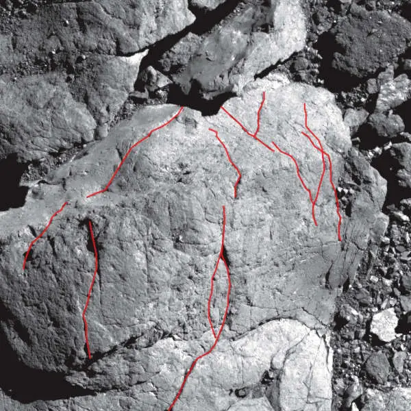
The PolyCam aboard NASA's OSIRIS-REx spacecraft provided high-resolution, microscope-like images of asteroid Bennu’s surface. This made it possible for researchers to map more than 1,500 rock fractures. Slide left on the example image to see the fractures highlighted in red. Credits: NASA/Goddard/University of Arizona. Scientists from NASA’s OSIRIS-REx mission recently learned that surface regeneration happens a lot quicker on asteroids than on Earth.
By analyzing rock fractures on asteroid Bennu from high-resolution images taken by the OSIRIS-REx spacecraft, the team discovered that the Sun’s heat fractures rocks on Bennu in just 10,000 to 100,000 years.
This information will help scientists estimate how long it takes boulders on asteroids like Bennu to break down into smaller particles, which may either eject into space or stay on the asteroid’s surface.
Tens of thousands of years might sound pretty slow, but “we thought surface regeneration on asteroids took a few millions of years,” said Marco Delbo, senior scientist at Université Côte d'Azur, CNRS, Observatoire de la Côte d'Azur, Laboratoire Lagrange, Nice, France, and lead author of a paper published June 2022 in Nature Geoscience. “We were surprised to learn that the aging and weathering process on asteroids happens so quickly, geologically speaking.”
Although landslides, volcanoes, and earthquakes can change the surface suddenly on Earth, usually changes are gradual. Water, wind, and temperature changes slowly break down rock layers, creating new surfaces over millions of years.
For example, if you were to hike into the Grand Canyon, you would see distinct rock layers; the top layers tend to be the youngest rocks, dating around 270 million years old, and the layers at the bottom of the canyon are the oldest, about 1.8 billion years old.
According to the U.S. National Park Service, the Colorado River has been carving down rocks in the Grand Canyon for 5 million to 6 million years.
Rapid temperature changes on Bennu create internal stress that fractures and breaks down rocks, similar to how a cold glass breaks under hot water. The Sun rises every 4.3 hours on Bennu. At the equator, daytime highs can reach almost 260 F (about 127 C), and nighttime lows plummet to nearly minus 10 F (about minus 23 C).
OSIRIS-REx scientists spotted cracks in the rocks in spacecraft images from the first surveys of the asteroid. The fractures seemed to point in the same direction, “a distinct signature that temperature shocks between the day and the night could be the cause,” said Delbo.
Delbo and his colleagues measured the length and angles of more than 1,500 fractures in OSIRIS-REx images by hand: some shorter than a tennis racket, others longer than a tennis court. They found the fractures predominantly align in the northwest-southeast direction, indicating they were caused by the Sun, which is shown here to be the primary force changing Bennu’s landscape.
“If landslides or impacts were moving boulders faster than the boulders were cracking, the fractures would point in random directions,” said Delbo.
The scientists used a computer model and their fracture measurements to calculate the 10,000 to 100,000-year timeframe for thermal fractures to propagate and split rocks.
“The thermal fractures on Bennu are quite similar to what we find on Earth and on Mars in terms of how they form,” said Christophe Matonti, a co-author of the paper at Université Côte d’Azur, CNRS, Observatoire de la Côte d’Azur, Géoazur, Sophia-Antipolis, Valbonne, France. “It is fascinating to see that they can exist and are similar in very ‘exotic’ physical conditions [low gravity, no atmosphere], even compared to Mars.”
“Keep in mind, the topography of Bennu is young, but the rocks on the asteroids are still billions of years old and hold valuable information about the beginning of the solar system,” said Jason Dworkin, OSIRIS-REx project scientist at NASA’s Goddard Space Flight Center in Greenbelt, Maryland.
OSIRIS-REx (Origins, Spectral Interpretation, Resource Identification, Security-Regolith Explorer) will return a sample from Bennu to Earth on Sept. 24, 2023. “We will be able to learn more details about the age of the surface when we are able to directly study the sample,” said Dworkin.
Goddard provides overall mission management, systems engineering, and the safety and mission assurance for OSIRIS-REx. Dante Lauretta of the University of Arizona, Tucson, is the principal investigator. The university leads the science team and the mission's science observation planning and data processing. Lockheed Martin Space in Littleton, Colorado, built the spacecraft and provides flight operations.
Goddard and KinetX Aerospace are responsible for navigating the OSIRIS-REx spacecraft. OSIRIS-REx is the third mission in NASA's New Frontiers Program, managed by NASA's Marshall Space Flight Center in Huntsville, Alabama, for the agency's Science Mission Directorate Washington.
Rani C. Gran works for NASA's Goddard Space Flight Center in Greenbelt, Maryland.
This direct air capture plant in Iceland was designed to capture 4,000 metric tons of carbon dioxide per year. Climeworks 2021 via AP Photos
When politicians talk about reaching “net zero” emissions, they’re often counting on trees or technology that can pull carbon dioxide out of the air. What they don’t mention is just how much these proposals or geoengineering would cost to allow the world to continue burning fossil fuels.
There are many proposals for removing carbon dioxide, but most make differences only at the edges, and carbon dioxide concentrations in the atmosphere have continued to increase relentlessly, even through the pandemic.
I’ve been working on climate change for over four decades. Let’s take a minute to come to grips with some of the rhetoric around climate change and clear the air, so to speak.
When fossil fuels are burned for energy or used in transportation, they release carbon dioxide – a greenhouse gas that is the main cause of global heating. Carbon dioxide stays in the atmosphere for centuries. As more carbon dioxide is added, its increasing concentration acts like a blanket, trapping energy near Earth’s surface that would otherwise escape into space.
When the amount of energy arriving from the Sun exceeds the amount of energy radiating back into space, the climate heats up. Some of that energy increases temperatures, and some increases evaporation and fuels storms and rains.
Because of these changes in atmospheric composition, the planet has warmed by an estimated 1.1 degrees Celsius (2 F) since about 1880 and is well on the way to 1.5 C (2.7 F), which was highlighted as a goal not to be crossed if possible by the Paris Agreement. With the global heating and gradual increases in temperature have come increases in all kinds of weather and climate extremes, from flooding to drought and heat waves, that cause huge damage, disruption and loss of life.
Currently, the main source of carbon dioxide is China. But accumulated emissions matter most, and the United States leads, closely followed by Europe, China and others.
Estimated shares of carbon dioxide emissions from fossil fuels in 2018 compared with cumulative emissions over time, based on data released by BP.Kevin Trenberth, Author provided
What works to slow climate change?
Modern society needs energy, but it does not have to be from fossil fuels.
Unfortunately, this changeover to renewables has been slow, due in large part to the the huge and expensive infrastructure related to fossil fuels, along with the vast amount of dollars that can buy influence with politicians.
Geoengineering often means “solar radiation management,” which aims to emulate a volcano and add particulates to the stratosphere to reflect incoming solar radiation back to space and produce a cooling. It might partially work, but it could have concerning side effects.
The global warming problem is not sunshine, but rather that infrared radiation emitted from Earth is being trapped by greenhouse gases. Between the incoming solar and outgoing radiation is the whole weather and climate system and the hydrological cycle. Sudden changes in these particles or poor distribution could have dramatic effects.
The last major volcanic eruption, of Mt. Pinatubo in 1991, sent enough sulfur dioxide and particulates into the stratosphere that it produced modest cooling, but it also caused a loss of precipitation over land. It cooled the land more than the ocean so that monsoon rains moved offshore, and longer term it slowed the water cycle.
Carbon capture and storage has been researched and tried for well over a decade but has sizable costs. Only about a dozen industrial plants in the U.S. currently capture their carbon emissions, and most of it is used to enhance drilling for oil.
Direct air capture – technology that can pull carbon dioxide out of the air – is being developed in several places. It uses a lot of energy, though, and while that could potentially be dealt with by using renewable energy, it’s still energy intensive.
Planting trees is often embraced as a solution for offsetting corporate greenhouse gas emissions. Trees and vegetation take up carbon dioxide though photosynthesis and produce wood and other plant material. It’s relatively cheap.
But trees aren’t permanent. Leaves, twigs and dead trees decay. Forests burn. Recent studies show that the risks to trees from stress, wildfires, drought and insects as temperatures rise will also be larger than expected.
How much does all this cost?
Scientists have been measuring carbon dioxide at Mauna Loa, Hawaii, since 1958 and elsewhere. The average annual increase in carbon dioxide concentration has accelerated, from about 1 part per million by volume per year in the 1960s to 1.5 in the 1990s, to 2.5 in recent years since 2010.
This relentless increase, through the pandemic and in spite of efforts in many countries to cut emissions, shows how enormous the problem is.
Carbon dioxide concentrations at Mauna Loa, Hawaii. The monthly mean, in red, rises and falls with the growing seasons. The black line is adjusted for the average seasonal cycle.Kevin Trenberth, based on NOAA data, CC BY-ND
Usually carbon removal is discussed in terms of mass, measured in megatons – millions of metric tons – of carbon dioxide per year, not in parts per million of volume. The mass of the atmosphere is about 5.5x10¹⁵ metric tons, but as carbon dioxide (molecular weight 42) is heavier than air (molecular weight about 29), 1 part per million by volume of carbon dioxide is about 7.8 billion metric tons.
According to the World Resources Institute, the range of costs for direct air capture vary between US$250 and $600 per metric ton of carbon dioxide removed today, depending on the technology, energy source and scale of deployment. Even if costs fell to $100 per metric ton, the cost of reducing the atmospheric concentrations of carbon dioxide by 1 part per million is around $780 billion.
Tree restoration on one-third to two-thirds of suitable acres is estimated to be able to remove about 7.4 gigatons of carbon dioxide by 2050 without displacing agricultural land, by WRI’s calculations. That would be more than any other pathway. This might sound like a lot, but 7 gigatons of carbon dioxide is 7 billion metric tons, and so this is less than 1 part per million by volume. The cost is estimated to be up to $50 per metric ton. So even with trees, the cost to remove 1 part per million by volume could be as much as $390 billion.
So for hundreds of billions of dollars, the best prospect with these strategies is a tiny dent of 1 part per million by volume in the carbon dioxide concentration.
This arithmetic highlights the tremendous need to cut emissions. There is no viable workaround.
LAKE COUNTY, Calif. — The Board of Supervisors this week gave its support to a plan for recruiting a new Community Development Department director.
The current director, Mary Darby, gave the board her resignation after a closed session evaluation on Tuesday, July 12. It’s effective Nov. 4.
Human Resources Director Pam Samac laid out the plan for the recruitment to find the seventh director for Community Development since 2016.
She said they opened the recruitment on July 14. If they don’t get a decent pool of qualified candidates, they want to put it out to 10 recruiters to find one to lead the process.
After reviewing the candidates, if it’s warranted, Samac wants to schedule interviews with the board.
Supervisor Bruno Sabatier said he wanted the county to use professional recruitment firms to find department director jobs.
Samac said it’s possible the county could get a number of good candidates as they did recently for the assistant county administrative officer without using a recruiter. She added that during the last six months ago the county has started getting better candidates for senior positions.
She advocated for the county starting the recruitment on its own and waiting three weeks before paying $25,000 to $30,000 for a recruiter.
At the same time, she said they could put out a bid request to recruiters so that it can be underway while the county is taking initial applications.
The county is now conducting another recruitment for a Public Health officer. Samac said the recruitment agencies her recruiter network uses are very busy, and have been saying they are too busy to even give quotes for services. However, that could have changed and she said they could ask for bids again.
Samac said she would have the first review of applications on Aug. 9. At that point, she said they already had one qualified applicant.
She said that they could make an assessment on Aug. 9 about what applicants they have. “I don’t believe that you have to have four or five to compare and contrast if you have one great candidate.”
At the suggestion of County Administrative Officer Susan Parker, the board agreed to have a standing item on its closed session agenda to discuss the recruitment.
Darby suggested to the board that they also advertise the job with the American Planning Association, as she said that’s where all the certified planners are and the county can get some great candidates there.
Email Elizabeth Larson at This email address is being protected from spambots. You need JavaScript enabled to view it.. Follow her on Twitter, @ERLarson, or Lake County News, @LakeCoNews.
LAKE COUNTY, Calif. — As Sutter Lakeside Hospital’s Birth Center remains closed due to lack of a dedicated physician, officials with the county, other hospitals and the nurses union have offered additional details on the situation.
Sutter Lakeside closed its birth center on Tuesday afternoon at 4 p.m. due to having no available obstetrician to deliver babies, as Lake County News has reported.
At that point, the hospital went on “diversion” and began directing expectant mothers to other hospitals around the region.
The hospital said it anticipates resolving the situation to be resolved by 7 a.m. Wednesday, July 27, and that it is “actively working with community resources to help patients access appropriate care and to facilitate transfers to other hospitals as necessary.”
The California Nurses Association — whose members are in ongoing negotiations with Sutter Health and conducted an informational picket earlier this year over issues including safety and staffing — weighed in on the situation, calling on Sutter “to immediately provide the community with a comprehensive plan to ensure safe, stable and consistent obstetric services.”
The union accused Sutter Health of putting profits over patients, noting, “Sutter management has relied on just two obstetric providers, throughout two years of pandemic instability, despite repeated warnings from Registered Nurses and providers.”
The closure of the Sutter Lakeside Birth Center left only one place to deliver in Lake County — Adventist Health Clear Lake.
“We are prepared and ready to accept birthing mothers who are being diverted,” Kim Lewis, spokesperson for Adventist Health Clear Lake, told Lake County News on Thursday.
Lewis said Sutter had reached out to Adventist regarding its action, “and we are working closely with them and have a plan in place.”
In addition to Adventist Health Clear Lake, Sutter Lakeside is reportedly directing patients to Kaiser Santa Rosa, Queen of the Valley in Napa and Santa Rosa Memorial Hospital.
On Thursday, Adventist Health Ukiah Valley contacted Lake County News to report that it also is welcoming birth center patients that are being diverted from Sutter Lakeside.
County officials reported on Thursday that they also are working with Sutter Lakeside to address the matter.
“County of Lake Health Services was made aware of this before its occurrence and has been supporting Sutter Lakeside where possible,” Dwight Coddington, spokesman for the Lake County Health Services Department, told Lake County News in a Thursday email.
Coddington said that if a patient does require an obstetrician they will be referred to Sutter in Santa Rosa, and that other providers — such as Adventist Hospital and the regional hospitals where patients are being referred — aren’t being impacted due to Sutter Lakeside’s obstetrics bypass.
The California Nurses Association told Lake County News that it is “deeply concerned for the patients and families of Lake County as well as adjacent Napa and Mendocino counties with the alarming news that Sutter Lakeside Hospital has failed to secure stable obstetric services resulting in temporary closure or ‘diversion’ of its perinatal services.”
Noting that the rural hospital provides vital health care services, including perinatal services to Lake, Napa and Mendocino County families, the union said, “This temporary closure or ‘diversion’ adds significant time and travel to a journey that can and often does cause significant risk to the well-being of the expectant mother and baby.”
Email Elizabeth Larson at This email address is being protected from spambots. You need JavaScript enabled to view it.. Follow her on Twitter, @ERLarson, or Lake County News, @LakeCoNews.
LAKE COUNTY, Calif. — Sutter Lakeside Hospital has temporarily closed its birth center due to lack of an obstetrician and is diverting patients to other hospitals around the region until next week.
In a written statement released to Lake County News on Wednesday evening, Sutter Health said it does not currently have inpatient obstetric service capabilities.
“While we anticipate the situation will be resolved within a week, we are also actively working with community resources to help patients access appropriate care and to facilitate transfers to other hospitals as necessary. Other hospital services, including emergency services, remain open and ready to care for the community,” the statement said.
Sutter Health media relations manager Monique Binkley Smith told Lake County News that the hospital has been on “diversion” since 4 p.m. Tuesday.
Binkley Smith said Sutter was in the process of notifying patients of the situation.
The closure of Sutter Lakeside’s Birth Center leaves only Adventist Health Clear Lake as an available option in Lake County for deliveries.
On Wednesday, the Mother-Wise — The Village Facebook page posted a message stating that the group had been notified by Sutter Lakeside staff that morning that the birth center had closed due to no provider availability.
The group said the hospital reported it would be diverting patients to other hospitals until 7 a.m. Wednesday, July 27.
Hospitals where patients are being diverted included Adventist Health Clare Lake, Kaiser Santa Rosa, Queen of the Valley in Napa and Santa Rosa Memorial Hospital, the group reported.
Expecting parents are urged to contact their obstetricians’ offices to get additional information.
Email Elizabeth Larson at This email address is being protected from spambots. You need JavaScript enabled to view it.. Follow her on Twitter, @ERLarson, or Lake County News, @LakeCoNews.
On Friday, Gov. Gavin Newsom pushed California to move faster to reach its climate goals, setting ambitious new targets for renewable energy, clean buildings, carbon removal and clean fuels in the transportation sector.
The governor’s accelerated climate plan reinforces California’s leadership in addressing climate change, and will move the state faster toward carbon neutrality.
In a letter to the chair of the California Air Resources Board, or CARB, Gov. Newsom called for the state to ensure that the 2022 Climate Change Scoping Plan provides a path to achieve both the 2030 climate goal and state carbon neutrality no later than 2045, requesting that the final plan incorporate new efforts to advance offshore wind, clean fuels, climate-friendly homes, carbon removal and addressing methane leaks.
Last month, Gov. Newsom signed a state budget that will make it easier to bring clean energy projects online, speeding up the environmental review process of new clean energy projects, and helping the state move away from electricity generated from fossil fuels.
The governor also announced that he will work with the Legislature to enshrine carbon neutrality into state law, increase the state’s ambition towards our 2030 climate goals and accelerate our clean energy targets, while supporting carbon sequestration from our natural and working lands and advancing safe and equitable engineered carbon removal.
He will also work to finalize the state’s historic investments under the $53.9 billion climate commitment, with a focus on equity and community resilience, while expanding opportunities for climate innovation and manufacturing here in California.
“California communities experience the devastating impacts of climate change every day. We need to supercharge our efforts to significantly reduce harmful carbon pollution. The state’s draft carbon neutrality road map doesn’t go far enough or fast enough. That’s why I’m pushing state agencies to adopt more aggressive actions, from offshore wind to climate-friendly homes, and to make sure we never build another fossil fuel power plant in California again,” said Governor Newsom.
The new targets and requested actions outlined in the letter include:
• Offshore wind: Establishing a California Energy Commission planning goal of at least 20GW of offshore wind in 2045. • Clean and healthy buildings: Creating a goal of 3 million climate-ready and climate-friendly homes by 2030 and 7 million by 2035, supplemented by 6 million heat pumps by 2030, and directing 50 percent of investments to low-income and disadvantaged communities. • Moving away from fossil fuels: Directing state agencies to plan for an energy transition to meet our long-term energy goals that avoids the need for new natural gas plants, while ensuring reliability. Establishing a 20 percent clean fuels target for the aviation sector. The Governor also requested that CARB evaluate a more stringent Low Carbon Fuel Standard and accelerate refinery transitions to clean fuels production. • Methane: Forming a Task Force to identify and address methane leaks from oil infrastructure near communities, recognizing the threats these leaks can pose to community health and safety. • Carbon removal: Setting a 20 MMT carbon removal target for 2030 and 100 MMT carbon removal target for 2045, emphasizing the role of natural and working lands and the need for safe and equitable engineered carbon removal. • Increasing climate ambition: Partnering with the Legislature to make carbon neutrality state law and accelerate progress toward California’s 2030 target; bring new ambition to the state’s clean energy goals; develop policy to support sequestration from natural and working lands while incorporating industrial carbon capture in carbon neutrality efforts; and finalize investments under the state’s $53.9 billion Climate Commitment.
The California Air Resources Board will meet in the fall to consider adopting a final draft of the 2022 Climate Change Scoping Plan.
Gov. Newsom on Friday also announced the launch of a new climate dashboard highlighting state climate action and progress toward key targets.
CalEPA will continue to expand the dashboard to help Californians understand the actions the state is taking to adapt to a changing climate, and track progress in areas such as zero-emission vehicle sales, clean energy job creation and consumer savings from energy efficiency standards.
Sunset over Condor Ridge in Northern California. Photo by Bob Wick. The effort to expand the Berryessa Snow Mountain National Monument continues to move ahead in Congress.
On Thursday, the U.S. Senate Committee on Energy & Natural Resources passed the Berryessa Snow Mountain National Monument Expansion Act (S. 4080) with unanimous and bipartisan support.
The bill, introduced by Sen. Alex Padilla (D-CA) with Sen. Dianne Feinstein as co-sponsor, is a companion to H.R. 6366, introduced by Congressman John Garamendi.
Advocates and the Yocha Dehe Wintun Nation are thrilled this legislation, which would permanently protect a unique Northern California landscape, has received bipartisan support in the Senate.
“Glad to see my bill to expand the existing Berryessa Snow National Monument and give Tribal governments a seat at the table to better manage and care for these sacred Tribal lands move forward today,” said Sen. Padilla. “The sacred lands within and around the Berryessa Snow Mountain National Monument are central to thousands of years of tribal origin stories. It is our duty to protect the abundant natural resources and the rich history on Molok Luyuk for today’s children and for future generations, and I look forward to working to ensure we see this bill to fruition.”
The legislation would add an adjacent 3,925 acres to the current Monument, support tribal co-management, and change the name of the additional wildlands from “Walker Ridge” to Molok Luyuk — Patwin for “Condor Ridge” — a name the Yocha Dehe Wintun Nation provided.
“Molok Luyuk is home to both profound natural beauty and deep cultural significance. It is a special place, so it's fitting that California’s tribes and the U.S. government create a special relationship to protect it,” said Yocha Dehe Wintun Nation Chairman Anthony Roberts. “We commend Senator Padilla and Senator Feinstein for their work on this bill.”
In 2015, President Obama designated Berryessa Snow Mountain National Monument with Congressman Mike Thompson (D-CA05) who introduced the original bill.
The monument, along with the proposed Molok Luyuk addition, is culturally significant to local Native American tribes and notable for its varied habitats and wildlife, including imperiled animals. The legislation would not impact privately owned, state, tribal, or non-federal land in any way.
“Molok Luyuk is a special landscape of fascinating geology, rich biodiversity, profound cultural significance, and beautiful views. This place is worthy of the permanent protection that Sen. Alex Padilla and Representative John Garamendi have proposed," said Sierra Club Redwood Chapter Chair Victoria Brandon.
Molok Luyuk includes public land adjacent to the existing monument that is administered by the Bureau of Land Management.
The ridge is home to great biodiversity including over 30 species of rare plants, ancient blue oak woodlands, rugged rock outcrops, wildflower meadows, and extensive stands of McNab cypress. The area also provides wildlife connectivity for many species including deer, mountain lions, and black bear.
“This markup is an important milestone following decades of advocacy,” California Native Plant Society Conservation Program Director Nick Jensen said. “The bipartisan support for this legislation is a marvelous sign that we are on a strong path toward permanently protecting a region that is biologically precious and of great significance to Native American communities. We thank Sen. Padilla for his exceptional leadership in expanding Berryessa Snow Mountain National Monument and honoring the area’s profound significance to our tribal partners.”
The Berryessa Snow Mountain National Monument Expansion Act would provide much-needed, lasting protection for the land along with the requirement for a Monument Management Plan within one year.
The legislation also calls for cooperative management with tribes or tribal partners in the development of the management plan and subsequent management decisions.The land is of tremendous present-day cultural and religious importance to the Yocha Dehe Wintun Nation, and includes sites central to their origin stories. The cooperative management provision would help safeguard this one-of-a-kind area in partnership with local Indigenous tribes.
"Molok Luyuk is a rare gem. It is filled with wildlife, rare plants, and indigenous treasures that local residents have long appreciated. We are excited to see this legislation progress through the Senate and thankful to the leadership of senators Padilla and Feinstein,” said Sandra Schubert, executive director of Tuleyome. “We are grateful they have supported the effort to protect Molok Luyuk from current and future threats while respecting Tribal stewardship over the lands.”
The bill would also increase recreational access to world-class nature and outdoor activities for locals and visitors. Popular recreation activities on these lands include hiking, sightseeing, mountain biking, camping, horseback riding, and off highway vehicle use on designated routes. Incorporating the area into the existing monument would improve land management, bring additional resources for trail construction and maintenance, help improve public access, and protect sensitive wildlife and prime habitat areas.
This will also help ensure equitable access to the outdoors in a county where 22% of residents identify as Hispanic or Latino.
“We admire Sen. Alex Padilla for being a reliable champion for public lands since taking office,” said Ryan Henson, Senior Policy Director for CalWild. “We are thrilled to see the bill to protect Molok Luyuk pass this milestone in Congress. This place is a public treasure and deserves permanent protection and improved management.”
The expanded monument also would mark an important step toward helping the state of California and the Biden Administration meet the critical goal of protecting 30 percent of U.S. lands and waters by the year 2030, added Elyane Stefanick, California Program Director for the Conservation Lands Foundation, in reference to California’s 30x30 Initiative and the federal America the Beautiful call-to-action.
LAKE COUNTY, Calif. — A Clearlake man was arrested early Wednesday after police said he hit and killed a pedestrian while driving under the influence of alcohol.
The crash, which occurred just before 1 a.m. Wednesday, claimed the life of 43-year-old Clearlake resident James Torrey Jr., according to the Clearlake Police Department.
Police identified the driver in the crash as James Nielsen, 27.
The agency said that at approximately 1 a.m. Clearlake Police officers responded to Highway 53 just north of Dam Road for a report of a traffic collision involving a vehicle and a pedestrian.
Upon arrival, officers found the collision involved a Toyota Tacoma occupied by one person, later identified as Nielsen, and Torrey, the pedestrian.
Torrey sustained major injuries and was pronounced deceased at the scene, while Nielsen sustained minor injuries, police said.
As a result of the investigation and based upon probable cause, officers arrested Nielsen on suspicion of driving under the influence of alcohol and vehicular manslaughter.
He was booked into the Lake County Jail and released later on Wednesday, according to jail records.
A portion of Highway 53 was closed until just after 6:30 a.m. Wednesday as the investigation took place.
Police ask anyone who witnessed the crash to contact Det. Trevor Franklin by email at This email address is being protected from spambots. You need JavaScript enabled to view it. or by phone at 707-994-8251.

 How to resolve AdBlock issue?


