CLEARLAKE, Calif. — Clearlake Animal Control has dogs waiting to be adopted into new homes.
The City of Clearlake Animal Association also is seeking fosters for the animals waiting to be adopted.
Call the Clearlake Animal Control shelter at 707-273-9440, or email This email address is being protected from spambots. You need JavaScript enabled to view it. to inquire about adoptions and schedule a visit to the shelter.
Visit Clearlake Animal Control on Facebook or on the city’s website.
LAKE COUNTY, Calif. — The Board of Supervisors will hold a special Friday afternoon meeting to discuss an affordable housing project for Behavioral Health Services clients to be built in Nice and to consider approving a request from the Lake County Sheriff’s Office to ratify a local emergency proclamation for the atmospheric river event.
The board will meet beginning at 1 p.m. Friday, Jan. 13, in the board chambers on the first floor of the Lake County Courthouse, 255 N. Forbes St., Lakeport.
The meeting ID is 924 1464 6983, pass code 216475. The meeting also can be accessed via one tap mobile at +16699006833,,92414646983#,,,,*216475#.
All interested members of the public that do not have internet access or a Mediacom cable subscription are encouraged to call 669-900-6833, and enter the Zoom meeting ID and pass code information above.
On Friday afternoon the board, sitting as the Lake County Housing Commission, will hear a presentation describing the financing and funding sources and relative positions of the lienholders for the Collier Avenue Affording Housing Project, also referred to in county documents as the No Place Like Home Permanent Supportive Housing Project.
The project will be located on 3.3 acres at 6853 Collier Ave. in Nice.
The Rural Communities Housing Development Corp., or RCHDC, based in Ukiah, will develop the affordable housing project, which will serve low income or very low income households meeting the definition of mental disorder, substance substance use disorder or at risk of homelessness.
It will consist of 40 units, most one- and two-bedroom apartments with one unit set aside for a manager.
RCHDC previously reported that 49% of the units are set aside for clients suffering with serious mental illness and those who are at risk of homelessness, who are clients of Behavioral Health Services.
County documents explain that the project will house adults 18 years and older with a “serious mental disorder” as defined by the California Code, Welfare and Institutions Code. Under that code, serious mental disorders include bipolar, post-traumatic stress disorder, schizophrenia, major affective disorders or other severely disabling mental disorders.
As part of the discussion, the board will consider a host of final agreements for the project. In his report to the board Behavioral Health Services Director Todd Metcalf, whose department would refer clients to the project for housing, said the documents “represent the final step in executing the Collier Avenue Housing project, prior to breaking ground.”
In other business on Friday, Sheriff Rob Howe is asking the board to ratify the proclamation of the existence of a local emergency due to the atmospheric river event that Howe signed on Thursday.
The proclamation notes that the atmospheric river event began on Jan. 4 and that, as a result, a local emergency now exists throughout Lake County.
Email Elizabeth Larson at This email address is being protected from spambots. You need JavaScript enabled to view it.. Follow her on Twitter, @ERLarson, or Lake County News, @LakeCoNews.
UPPER LAKE, Calif. — The Western Region Town Hall will hold its first meeting of the year on Wednesday, Jan. 18.
The meeting will take place from 5:30 to 7 p.m. at the Habematolel community center, 9460 Main St. in Upper Lake.
Community members also can attend via Zoom. The link is here.
The meeting ID is 982 1265 6300, pass code is 988681. Dial by location: +1 669 900 6833.
Discussion items include the Upper Lake levees, code enforcement, fire preparedness, drought and “HAWK” crosswalks.
They also will talk about a letter to the Board of Supervisors for funding for audio and video for meetings, universal trash pickup and the bylaws subcommittee.
Everyone is welcome to attend.
WRTH council members include Chair Tim Chiara, records keeper Linda Alexander, and members Thomas Aceves, Dave Eby, Kathryn Parankema, Claudine Pedroncelli and Melinda Wright.
Using data from NASA’s Transiting Exoplanet Survey Satellite, scientists have identified an Earth-size world, called TOI 700 e, orbiting within the habitable zone of its star – the range of distances where liquid water could occur on a planet’s surface. The world is 95% Earth’s size and likely rocky.
Astronomers previously discovered three planets in this system, called TOI 700 b, c, and d. Planet d also orbits in the habitable zone. But scientists needed an additional year of TESS observations to discover TOI 700 e.
“This is one of only a few systems with multiple, small, habitable-zone planets that we know of,” said Emily Gilbert, a postdoctoral fellow at NASA’s Jet Propulsion Laboratory in Southern California who led the work. “That makes the TOI 700 system an exciting prospect for additional follow up. Planet e is about 10% smaller than planet d, so the system also shows how additional TESS observations help us find smaller and smaller worlds.”
Gilbert presented the result on behalf of her team at the 241st meeting of the American Astronomical Society in Seattle. A paper about the newly discovered planet was accepted by The Astrophysical Journal Letters.
TOI 700 is a small, cool M dwarf star located around 100 light-years away in the southern constellation Dorado. In 2020, Gilbert and others announced the discovery of the Earth-size, habitable-zone planet d, which is on a 37-day orbit, along with two other worlds.
The innermost planet, TOI 700 b, is about 90% Earth’s size and orbits the star every 10 days. TOI 700 c is over 2.5 times bigger than Earth and completes an orbit every 16 days. The planets are probably tidally locked, which means they spin only once per orbit such that one side always faces the star, just as one side of the Moon is always turned toward Earth.
TESS monitors large swaths of the sky, called sectors, for approximately 27 days at a time. These long stares allow the satellite to track changes in stellar brightness caused by a planet crossing in front of its star from our perspective, an event called a transit. The mission used this strategy to observe the southern sky starting in 2018, before turning to the northern sky. In 2020, it returned to the southern sky for additional observations. The extra year of data allowed the team to refine the original planet sizes, which are about 10% smaller than initial calculations.
“If the star was a little closer or the planet a little bigger, we might have been able to spot TOI 700 e in the first year of TESS data,” said Ben Hord, a doctoral candidate at the University of Maryland, College Park and a graduate researcher at NASA’s Goddard Space Flight Center in Greenbelt, Maryland. “But the signal was so faint that we needed the additional year of transit observations to identify it.”
TOI 700 e, which may also be tidally locked, takes 28 days to orbit its star, placing planet e between planets c and d in the so-called optimistic habitable zone.
Scientists define the optimistic habitable zone as the range of distances from a star where liquid surface water could be present at some point in a planet’s history. This area extends to either side of the conservative habitable zone, the range where researchers hypothesize liquid water could exist over most of the planet’s lifetime. TOI 700 d orbits in this region.
Finding other systems with Earth-size worlds in this region helps planetary scientists learn more about the history of our own solar system.
Follow-up study of the TOI 700 system with space- and ground-based observatories is ongoing, Gilbert said, and may yield further insights into this rare system.
“TESS just completed its second year of northern sky observations,” said Allison Youngblood, a research astrophysicist and the TESS deputy project scientist at Goddard. “We’re looking forward to the other exciting discoveries hidden in the mission’s treasure trove of data.”
TESS is a NASA Astrophysics Explorer mission led and operated by Massachusetts Institute of Technology in Cambridge, Massachusetts, and managed by NASA's Goddard Space Flight Center. Additional partners include Northrop Grumman, based in Falls Church, Virginia; NASA’s Ames Research Center in California’s Silicon Valley; the Center for Astrophysics | Harvard & Smithsonian in Cambridge, Massachusetts; MIT’s Lincoln Laboratory; and the Space Telescope Science Institute in Baltimore. More than a dozen universities, research institutes, and observatories worldwide are participants in the mission.
Jeanette Kazmierczak works for NASA's Goddard Spaceflight Center, Greenbelt, Md.
Newly discovered Earth-size planet TOI 700 e orbits within the habitable zone of its star in this illustration. Its Earth-size sibling, TOI 700 d, can be seen in the distance. Credit: NASA/JPL-Caltech/Robert Hurt.
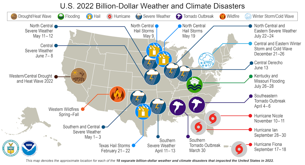
U.S. weather disasters are getting costlier as more people move into vulnerable areas and climate change raises the risks of extreme heat and rainfall, the National Oceanic and Atmospheric Administration warned as it released its annual billion-dollar disasters report on Jan. 10, 2023.
Even with an average hurricane season, 2022 had the third-highest number of billion-dollar disasters in the U.S. since 1980.
In all, 18 disasters each caused more than US$1 billion in damage. The list included three hurricanes, two tornado outbreaks, a destructive fire season, several extreme storms and a drought that disrupted sectors across the economy.
2022 had 18 disasters that exceeded $1 billion each in damage.NCEI/NOAA
It was also the third-costliest year, compared to past years adjusted for inflation, due primarily to Hurricane Ian’s widespread damage in Florida. Together, the 2022 disasters topped $165 billion, not counting the damage still being tallied from December’s winter storms.
Several scientists wrote about the year’s weather disasters and connections to climate change. Here are three essential reads from The Conversation’s archive:
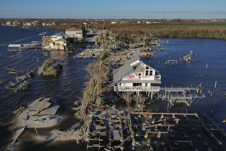
1. Hurricane Ian
The most expensive U.S. weather disaster of 2022 was Hurricane Ian, which grew into a monster of a storm over the warm waters of the Gulf of Mexico in late September.
Ian hit the barriers islands off Fort Myers, Florida, with 150-mph sustained winds, tying for the fifth-strongest wind speed at U.S. landfall on record. Its storm surge swept through coastal neighborhoods, where the population has boomed in recent years, and its rainfall deluged a large swath of the state. Twenty inches of rain fell in Daytona Beach, triggering erosion with devastating consequences.
At least 144 deaths were attributed to the storm in Florida alone, and the total damage neared $113 billion.
Hurricane Ian’s wind and storm surge tore up homes and roads on the Gulf Coast.Win McNamee/Getty Images
For example, “it is clear that climate change increases the upper limit on hurricane strength and rain rate, and that it also raises the average sea level and therefore storm surge,” Barlow and Camargo wrote.
Less clear is global warming’s influence on hurricane frequency, though research points to an uptick in the strength of storms that do form. “We expect more of them to be major storms,” Barlow and Camargo wrote. “Hurricane Ian and other recent storms, including the 2020 Atlantic season, provide a picture of what that can look like.”
2. The drought
The second-costliest disaster, at over $22 billion, was the widespread drought across much of the U.S. West and parts of the Midwest. It left reservoirs near record lows, disrupted farming in several states and temporarily shut down barge traffic on the Mississippi River.
At one point, 2,000 barges were backed up along the river, where 92% of U.S. agriculture exports travel.
The Mississippi River drought in October 2022.
Rivers the size of the Mississippi can be slow to respond to droughts, but during the flash drought of 2022, the river fell 20 feet in less than three months – even though its major tributaries were flowing at normal levels, wrote earth scientists Ray Lombardi, Angela Antipova and Dorian Burnette of the University of Memphis.
“Warmer atmospheric temperatures have the potential to evaporate more water, causing drought, and to hold more water, causing extreme rainfall,” the scientists wrote. “Over the past 100 years, year-to-year changes from very dry to very wet in the Mississippi River Valley have become more frequent. We expect this trend to continue as global temperatures continue to rise because of climate change.”
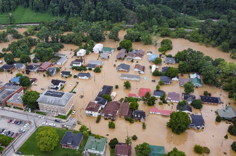
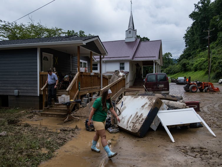
3. Extreme storms and flooding
Flash flooding swept through mountain valleys in eastern Kentucky in July 2022, killing more than three dozen people. It was one of several destructive flash floods.Seth Herald/AFP via Getty Images
Many of 2022’s billion-dollar disasters involved extreme storms, including hail, tornadoes, and a derecho that damaged power lines from Wisconsin to West Virginia.
It was also a summer of flooding, beginning with rain falling on snow that turned the Yellowstone River into a record-shattering torrent. St. Louis, Dallas, eastern Kentucky, southern Illinois and Death Valley were all hit with 1,000-year floods. Storms in the South knocked out Jackson, Mississippi’s fragile water supply for weeks.
Some of that is basic physics – warmer air increases the amount of moisture that the atmosphere can hold by about 7% per degree Celsius. Increased humidity can enhance latent heat in storms, increasing their intensity and leading to heavier rainfall, Wu explained.
Even though humans are becoming more adept at managing climate risks, research published in 2022 found that extreme flooding and droughts are still getting deadlier and more expensive, and the costs are likely to continue to rise.
“This past summer might just provide a glimpse of our near future as these extreme climate events become more frequent,” Wu wrote. “To say this is the new ‘normal,’ though, is misleading. It suggests that we have reached a new stable state, and that is far from the truth.”
This is a roundup of articles from The Conversation’s archives.
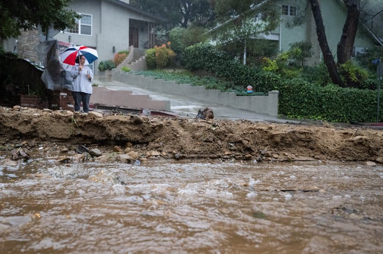
Rivers of muddy water from heavy rainfall raced through city streets as thousands of people evacuated homes downhill from California’s wildfire burn scars amid atmospheric river storms drenching the state in early January 2023.
The evacuations at one point included all of Montecito, home to around 8,000 people – and the site of the state’s deadliest mudslide on record exactly five years earlier.
Wildfire burn scars are particularly risky because wildfires strip away vegetation and make the soil hydrophobic – meaning it is less able to absorb water. A downpour on these vulnerable landscapes can quickly erode the ground, and fast-moving water can carry the debris, rocks and mud with it.
I study cascading hazards like this, in which consecutive events lead to human disasters. Studies show climate change is raising the risk of multiple compound disasters, including new research showing increasing risks to energy infrastructure.
When storms hit burn scars
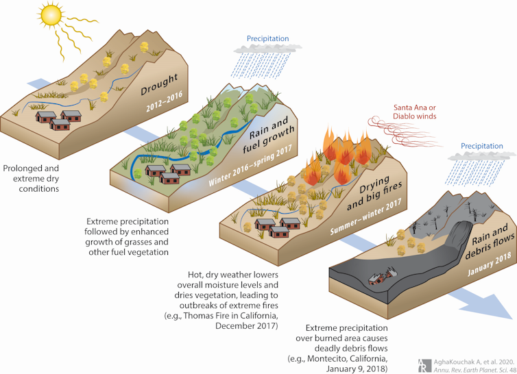
Five years ago, on Jan. 9, 2018, a deadly cascading disaster struck Montecito, a community in the coastal hills near Santa Barbara.
The cascade of events had started many months earlier with a drought, followed by a wet winter that fueled dense growth of vegetation and shrubs. An unusually warm and dry spring and summer followed, and it dried out the vegetation, turning it into fuel ready to burn. That fall, extreme Santa Ana and Diablo winds created the perfect conditions for wildfires.
The Thomas Fire began near Santa Barbara in December 2017 and burned over 280,000 acres. Then, on Jan. 9, 2018, extreme rainfall hit the region – including the burn scar left by the fire. Water raced through the burned landscape above Montecito, eroding the ground and creating the deadliest mudslide-debris flow event in California’s history. More than 400 homes were destroyed in about two hours, and 23 people died.
Video from the 2018 disaster in Montecito shows how quickly a mudslide can overtake a town.
These kinds of cascading events aren’t unique to California. Australia’s Millennium Drought (1997-2009) also ended with devastating floods that inundated urban areas and breached levees. A study linked some of the levee and dike failures to earlier drought conditions, such as cracks forming because of exposure to heat and dryness.
Individually, they might not have been disasters
When multiple hazards such as droughts, heat waves, wildfires and extreme rainfall interact, human disasters often result.
The individual hazards might not be very extreme on their own, but combined they can become lethal. These types of events are broadly referred to as compound events. For example, a drought and heat wave might hit at the same time. A cascading event involves compound events in succession, like wildfires followed by downpours and mudslides.
With compound and cascading events likely to become more common in a warming world, the ability to prepare for and manage multiple hazards will be increasingly essential.
At the same time, extreme rainfall events are expected to intensifyin a warming climate. A warmer atmosphere can hold more moisture, leading to wetter storms. This means more burned acres could be exposed to potentially extreme rainfall events in a warmer world.
Cascading hazards are not limited to rain over burned areas. For example, soot and ash deposits on snowpack can increase snowmelt, change the timing of runoff and cause snow-driven flooding.
It’s also important to recognize that human activities and local infrastructure can affect extreme events. Urbanization and deforestation, for example, can intensify flooding and worsen mud or debris flow events and their impacts. That was evident in the videos of muddy water pouring through streets in Santa Barbara County on Jan. 9, 2023.
In a recent study, colleagues and I also looked at the risks to energy infrastructure from cascading disasters involving intense rain over burn areas, focusing on natural gas pipelines and other infrastructure. Our results showed that not only will natural gas infrastructure be increasingly exposed to individual hazards, creating the potential for fires, the chances of cascading hazards are expected to increase substantially in a warming climate.
Managing multiple disasters and climate change
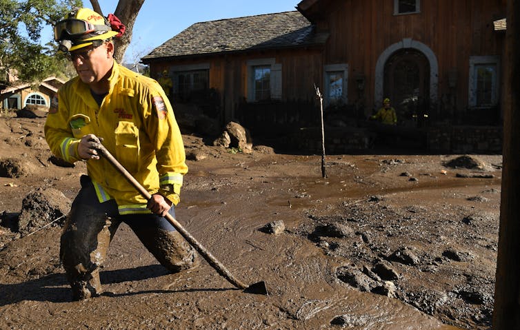
About a year after the devastating Montecito mudslide in 2018, I visited a location where damage to a natural gas pipeline hit by the mudslide led to a fire that burned multiple homes. Looking upstream, I could see many hills next to one another with similar burned scars, slopes and vegetation cover. Each one can be the ground zero for the next human disaster.
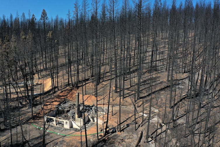
An aerial view of the location of the Dixie Fire near Greenville shows the bare soil left behind.Justin Sullivan/Getty Images
\Despite the high risk when extreme rainfall and droughts interact, most research in this area focuses on only rainfall or drought, but not both. Different government agencies oversee flood and drought monitoring, warning and management, even though both are extremes of the same hydrological cycle.
Emergency response has improved since the 2018 Montecito disaster, but it’s clear that communities and government agencies still aren’t fully prepared for the scale and potential impacts of future events.
This article was updated Jan. 10 with the Montecito evacuation lifted. The article is an update to a version published Oct. 24, 2021.
Lien Lloyd, shown in a screen capture from Lakeport Police body camera footage taken in the summer of 2022. LAKE COUNTY, Calif. — The Lakeport Police Department is asking for the community’s help in its effort to locate a woman reported missing in the fall.
The Lakeport Police Department said it is investigating the disappearance of Lien Merry Lloyd, 33. Her first name is pronounced “Lee-Ann.”
Lloyd’s mother contacted Lakeport Police on Oct. 6 to file a missing person report on her, telling police that she was last aware of her daughter being in Lakeport in July.
In August and September, the Lakeport Police Department had enforcement contacts with Lloyd.
At the time of the original report Lloyd was entered into the National Missing and Unidentified Persons System, which will trigger a notification to Lakeport Police should any other law enforcement agency run her in the National Crime Information System, which is a standard practice.
Lloyd is a white female, 5 feet 2 inches tall and 130 pounds, with brown hair and brown eyes.
She is reported to have a tattoo of a bird on either her right arm or right ankle.
“We are currently following some leads but have not located Lloyd,” the police department said.
Anyone who may have information on Lloyd’s whereabouts or who she may have been associated with dating back to July of 2022 is asked to contact Officer Katie Morfin by email at This email address is being protected from spambots. You need JavaScript enabled to view it. or by telephone at 707-263-5491.
You can also submit information anonymously by texting the words TIP LAKEPORT followed by your message to 888777.
Lien Lloyd, shown in a screen capture from Lakeport Police body camera footage taken in the summer of 2022.
LAKE COUNTY, Calif. — While California continues to deal with flood conditions in the middle of an extreme drought, state officials on Wednesday said more rain and snow are on the way as the state is reported to be at a full seasonal snowpack a full three months ahead of schedule.
State Climatologist Dr. Michael Anderson said the seventh atmospheric river since Christmas made its way over California on Wednesday, dropping more heavy rain of about 1.5 inches.
The forecast showed that the storm is expected to continue to bring rain until Saturday.
The rain of the past several weeks is continuing to help Clear Lake recover from its lowest levels since the 1970s.
The United States Geological Survey’s gauge on Clear Lake showed its level was at 1.7 feet Rumsey, the special measure for the lake, late Wednesday night. The lake was at -2.4 just before Christmas.
Anderson said river systems are continuing to fluctuate after every storm, with water levels rising but not coming down as much after the storms pass.
“The hydrologic conditions will continue to evolve, particularly in our larger rivers, even as the storms abate,” Andersonsaid.
He said atmospheric river No. 7 is fitting climatologically with the level of rain the state’s water system can manage.
Heading into the weekend, Anderson said storm No. 8 will have a broader statewide area for precipitation, with rainfall forecast from the Oregon border to San Diego.
There will be a heavier accumulation of 1 to 3 inches in mountainous areas along the coast as well as the Sierra Nevada, Anderson said.
Anderson said storm No. 9, expected from Jan. 18 to 19, looks to be more focused in the Northern Sierra and north of the Golden Gate region.
The freezing elevation is expected to be in the 4,000 to 6,000 foot range, which Anderson said is good news — it means that the storm is likely to build more snow.
After Jan. 20, the state should get a break from the rain, although Anderson said the forecast models are showing the potential for another storm system to come in around Jan. 27.
Anderson said California is looking to be in a better situation than last year, when rain shut off for three months.
“The Sierra Nevada has had a lot of precipitation” and is accumulating a lot of snow, Anderson said.
As of Wednesday, Anderson said the state’s automated sensors registered what is considered a full seasonal snowpack, which usually takes place around April 1.
The last really big snowpack was in 2019, which Anderson said was the fifth largest going back to the beginning of snowpack monitoring in 1950. Other large snowpacks in recent years were in 2005, 2006, 2011 and 2017.
He said officials will revisit some flood management concerns as the snow melts, especially if it’s too quickly.
For water storage statewide, “We’ve seen some really impressive gains in our reservoir storage,” Anderson said.
Smaller facilities have recovered depleted storage and hit the top of their conservation marks for winter and are now pivoting into flood management operations, where they hold excessive flows while the water moves through before letting it out. Anderson said those actions are coordinated with the U.S. Army Corps of Engineers.
Lake Shasta and Lake Oroville, the keystone projects for the Central Valley Project and State Water Project, respectively, have caught a lot of water, Anderson said.
While Shasta and Oroville still have a lot of room to go until they get back to average or top of conservation marks, Anderson said they are off of historic lows thanks to the storms.
Anderson said there are still areas where water storage is depleted, and challenges for the Colorado River system remain.
“There will be underlying components of drought that will linger even when this is all done,” he said.
Molly White, State Water Project water operations manager for the Department of Water Resources, said the overall storage level of California’s 154 reservoirs was at 84% of the historic average on Wednesday, up 3% from Tuesday.
Lake Shasta, which White said has had a “steep increase” in its storage over the past month, was at 1.9 million acre feet at that point, surpassing its level last year.
Lake Oroville was at 1.7 million acre feet on Wednesday, or 88% of its historical average, White said. The lake’s average this time of year is around 2 million acre feet.
Jeremy Arrich, manager of Water Resources’ Division of Flood Management, said that with more storms on the way, it’s necessary to keep paying attention to safety advice and emergency orders.
The California Nevada River Forecast Center showed that 22 river and water systems were above monitor stage and four were above flood stage as of Wednesday night.
Areas in flood stage continued to include the Russian River in Mendocino and Sonoma counties.
Arrich said Bear Creek in Merced County has experienced a flood of record this year.
Email Elizabeth Larson at This email address is being protected from spambots. You need JavaScript enabled to view it.. Follow her on Twitter, @ERLarson, or Lake County News, @LakeCoNews.
LAKE COUNTY, Calif. — Forecasters said more rain is expected in Lake County on Wednesday, with another storm that’s expected to hit the North Coast inbound later this week.
The National Weather Service's Eureka Office reported that Lake County had 6 to 8 inches of rainfall with some higher totals in the surrounding mountains of around 10 to 15 inches since Jan. 3, according to a report from the county of Lake on Tuesday.
And more is on the way.
State Climatologist Dr. Michael Anderson said the sixth atmospheric river to hit the state since Christmas moved over California on Tuesday, with the forecast showing it will continue into Wednesday, when more heavy rain is expected.
Across Lake County on Tuesday, the National Weather Service’s observation stations recorded levels ranging from an inch of rain in Upper Lake to 2 inches near Hidden Valley Lake and 2.25 inches south of Lake Pillsbury.
The rainfall and continued runoff from the previous storms pushed Clear Lake’s level up to just over 1.0 feet Rumsey as of Tuesday night.
Anderson said the next atmospheric river storm, expected to hit on Thursday, will be more focused on the North Coast. That will be the seventh atmospheric river.
The eighth is forecast to arrive on Saturday, with the ninth, and last, anticipated on Wednesday, Jan. 18.
Anderson said California may see a week of dry weather after that last storm in the series.
Those sites in the flood stage level include the Russian River in Hopland and Guerneville.
Jeremy Arrich, manager of the California Department of Water Resources’ Division of Flood Management, said the levels in Hopland are forecast to hover around flood stage for the next few days, but there has been no request for state assistance.
As of Tuesday, Arrich said the state’s Flood Operations Center has delivered flood fight equipment to 16 counties, including more than 389,000 sandbags, cix flood fight material containers, 3,000 fee of reinforcing muscle wall, more than 500,000 square feet of plastic sheeting for levee protection and deployed one flood fight specialist since the center was activated on Jan. 3.
Molly White, State Water Project water operations manager, said that as of Tuesday the average storage level of California’s 154 reservoirs was at 81% of the historic average.
The state also reported that the rain and high water has taxed aging water and sewer infrastructure, resulting in millions of gallons of sewage spills across the Bay Area.
In Lake County, Special Districts Administrator Scott Harter said they are doing “all right” in spite of all of the rain.
He told Lake County News that there were two small sewer spills due to the collection system surcharge on Monday morning in Clearlake but the agency was able to get pumper trucks dispatched quickly to relieve the system and stop the spills.
“They were both in the same reach of the collection system from two adjacent manholes in the Meadowbrook area,” Harter said.
The estimated volume was about 1,400 gallons from one, and 350 gallons from the other one. Harter said it was reported to the required agencies and appropriate actions were taken.
“The storm intensity has decreased significantly from last weekend and we are able to handle current flows without issue,” Harter said. “The longer range weather outlook looks promising as well with nothing quite as intense as we’ve experienced.”
Harter said the rest of the sewer systems are maintaining without issue and they got through the power outages without incident.
“Our water systems are looking good as well. We are experiencing intermittent treatment issues at our North Lakeport water treatment plant due to the turbidity of the water,” Harter said.
“On Sunday when turbidities were up we supplemented production with the intertie we have with the city of Lakeport water system,” Harter said. “Thankfully winter demands on the system are relatively low and we can meet them without concern.”
Email Elizabeth Larson at This email address is being protected from spambots. You need JavaScript enabled to view it.. Follow her on Twitter, @ERLarson, or Lake County News, @LakeCoNews.
From left, Rob Roumiguiere, Lake County Wine Alliance treasurer, presents a check for $10,000 to Clearlake Recreation and Events Coordinator Tina Viramontes as Marie Beery and Kaj Ahlmann of the Wine Alliance board look on at the Saw Shop in Kelseyville, California, on Thursday, Jan. 12, 2023. Courtesy photo. LAKE COUNTY, Calif. — An important new project in the city of Clearlake has received support courtesy of the annual Wine Auction.
On Thursday, the city of Clearlake received a $10,000 donation from the Lake County Wine Alliance to support the Clearlake Youth Center remodel project.
Since taking over the Clearlake Youth Center in October, city staff have been working on an extensive remodel, including replacing kitchen equipment, and replacing flooring, painting, and all-new activity equipment.
Once the Clearlake Youth Center remodel is completed, the creation of such programs like summer and day camps, youth classes, will be held at this facility.
The Clearlake Youth Center will also be available for youth event rentals.
All proceeds from events such as Breakfast with Santa, Bunny Brunch, comedy show fundraiser, and Movies in the Park goes directly to creating and maintaining the youth programs.
A portion of the building also will be used for a daycare for the children of Konocti Unified School District staff and city employees.
“The city is honored to receive these funds from the Lake County Wine Alliance, and we are extremely grateful for the assistance in getting this building and our youth programs up and running again. Our kids need it. A special thanks to Marie Beery for thinking of us and all her support for community programs,” said City Manager Alan Flora.
The check was delivered to city’s Recreation and Events Coordinator Tina Viramontes at the Saw Shop on Thursday.
Weston Seifert, owner of the Saw Shop, is the Lake County restaurant chairperson, and the Saw Shop catered the dinner for the 2022 Wine Auction.
LAKEPORT, Calif. — The city of Lakeport is introducing a telecommuting policy for its staff, a measure that’s meant to make the city more competitive in recruitment and retention.
The Lakeport City Council unanimously approved the new policy at its first meeting of the year on Tuesday, Jan. 3.
City Clerk/Administrative Services Director Kelly Buendia explained that, in the wake of the pandemic, the business landscape has changed with the onset of working from home, an opportunity adopted by a large number of both businesses and government agencies.
She and City Manager Kevin Ingram have been monitoring the practice, taking classes, looking at policies and talking to other cities to understand how it will impact Lakeport.
“We all came back to city hall and opened our offices much sooner” than some larger neighboring cities, she said.
Buendia said employees want the telecommuting policy, which offers a number of benefits — including increased productivity, overall happiness of certain employees, flexibility and the potential for reduced absenteeism.
Buendia said the city was directly impacted by the loss of two employees who were offered telecommuting opportunities with other agencies.
She emphasized that not every employee and every job is ideal for telecommuting, it isn’t an entitlement, and it has to be addressed by the department director and approved by the city manager.
Employees who want to participate would need to sign an agreement, Buendia said.
Councilwoman Kim Costa said she thought the issues with recruitment are very relevant, with many businesses and agencies going in the telecommuting direction. “It’s sort of a non option to say a hard no.”
Rather, Costa said it’s more of a question of how to do it. Costa said the policy is thoughtful and it’s important that the assessment of who can do it be consistent even though job assignments are different.
Councilman Kenny Parlet said he’s concerned about employees getting hurt at home if their workspaces are a “hodgepodge” with trip hazards and other dangers.
“Other than that, I think it’s a brilliant way to go. I think that it’s necessary,” he said.
Buendia said city staff will keep an eye on the policy, and can beef it up if necessary. She said they are going in with the mindset that it might need to be brought back and strengthened.
Councilman Michael Froio raised the issue about there being no break between work and home life for those taking advantage of telecommuting. He said it’s nice to come to a place where you work, then leave to go home.
Froio said his mind went to the same concern as Parlet’s regarding home office safety, adding that one questionable workers’ compensation claim could wipe out the whole program.
He said they are fortunate to have a city full of very dedicated workers, he’s appreciative of employees and wants to give them every chance possible. If this helps them be more productive and happier, “I’m for this.”
Ingram said the policy will require a work agreement with a workplace environment checklist, which employees must sign saying they will maintain their home work space.
He said staff would like to bring the policy back for occasional updates, adding that the city is already starting to feel the squeeze on the retention side because others are offering telecommuting.
Asked by Lake County News about how many staff have expressed interest in telecommuting, Buendia said they had one person in beta testing and that she didn’t foresee there being a lot more.
Ingram said the city probably has two to three staff who have expressed interest.
Costa, who works for the county of Lake, said some people want structure at the office and others thrive in working from home.
“It feels a little uncomfortable at first because it’s a little different,” she said of the practice.
Costa said she feels like she has more eyes on telecommuting staff even when they’re not in the office. “It’s an adventure that has a little bit of discomfort built into it.”
Parlet moved to approve the policy, which Costa seconded and the council approved 4-0, with Councilman Brandon Disney absent.
Email Elizabeth Larson at This email address is being protected from spambots. You need JavaScript enabled to view it.. Follow her on Twitter, @ERLarson, or Lake County News, @LakeCoNews.
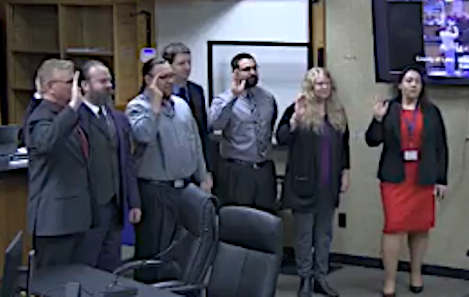
Officials elected last year took their oath of office at the Board of Supervisors meeting on Tuesday, Jan. 10, 2023. Zoom screen capture. LAKE COUNTY, Calif. — The Board of Supervisors held its first meeting of the year on Tuesday, during which newly elected officials were sworn in and the board chose its 2023 leadership.
At the start of Tuesday’s meeting, the board held its annual reorganization.
Supervisor Bruno Sabatier nominated Supervisor Jessica Pyska to be the chair for 2023, with Supervisor Moke Simon to be vice chair. Supervisor Michael Green seconded the motion, which was approved 5-0.
That was followed by a swearing-in ceremony for several reelected and newly elected county officials.
While their oaths needed to have been taken by Jan. 2, the group took their oaths together in a ceremonial swearing-in that’s customary at the board’s first meeting of the year following election years.
Registrar of Voters Maria Valadez administered the oath of office to supervisors EJ Crandell and Bruno Sabatier, and District Attorney Susan Krones, who were each reelected to second terms in 2022, and Superintendent of Schools Brock Falkenberg and Assessor-Recorder Richard Ford who won third terms last year.
Also taking their oaths were county employees stepping into new leadership roles — new Treasurer-Tax Collector Patrick Sullivan and County Clerk/Auditor-Controller Jenavive Herrington.
Sullivan succeeds Barbara Ringen and Herrington succeeds Cathy Saderlund.
Both Ringen and Saderlund retired in December, with more than 70 years of county service between them.
Not in attendance for the ceremony was Lake County’s new sheriff, Rob Howe.
Howe, who for the past 11 years has served as chief probation officer following 19 years with the Lake County Sheriff’s Office, was appointed sheriff by the board on Dec. 20. He succeeds Sheriff Brian Martin, who retired effective Dec. 30.
He took his oath on Jan. 2 at the Registrar of Voters Office.
Howe sent a message for Tuesday’s meeting, which Pyska read, apologizing for his absence and explaining that he was away for a week at the California State Sheriffs' Association’s sheriffs school, which is offered once every four years.
“I would like to sincerely thank the board for the faith and trust they have shown in me with this appointment to the position of Lake County sheriff. It means a great deal to me. I take the responsibility very seriously and I have every intention of rewarding their confidence,” Howe’s message said.
As a lifelong resident who has spent his entire professional career in local law enforcement, Howe said, “I am happy and excited to be given the opportunity to continue to serve the citizens of our county.”
Email Elizabeth Larson at This email address is being protected from spambots. You need JavaScript enabled to view it.. Follow her on Twitter, @ERLarson, or Lake County News, @LakeCoNews.

 How to resolve AdBlock issue?