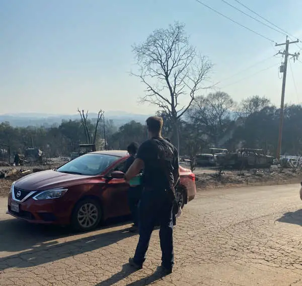
A property that was destroyed in the Cache fire on Wednesday, August 18, 2021, in Clearlake, California. The property was photographed on Sunday, August 22, 2021, during a brief repopulation operation. Photo courtesy of Jacqueline Snyder. LAKE COUNTY, Calif. — While firefighters have fully contained the Cache fire, fire district and city officials said Sunday that work in the fire’s footprint is still underway to make conditions safer for residents ahead of the lifting of the final evacuation order.
The fire, which began Wednesday afternoon in the area of Sixth Street and Cache Avenue in Clearlake, has burned 83 acres.
Lake County Fire Protection District Board President Jacqueline Snyder said Sunday afternoon that the fire was fully contained.
Snyder said firefighters will still be patrolling and monitoring the fire area over the next several days.
The fire did significant damage to power infrastructure. Snyder said Pacific Gas and Electric has mitigated most of the hazards related to damaged power equipment and has crews conducting work related to trees.
Those tree crews are expected to be on the scene for the next four days, Snyder said.
AT&T was in the fire area on Sunday, removing damaged phone lines. Snyder said the company won’t start phone service restoration until Monday.
City and fire officials issued an update on the situation on Sunday, reporting that a limited repopulation of the fire area was allowed from 5 to 7 p.m. Fire district personnel were there to hand out N95 masks to those going into the evacuation area.
City Manager Alan Flora said the final evacuation order, for zone CLE-E157-A, will be lifted at 8 a.m. Monday.
That zone covers everything in the city of Clearlake to the south of 18th Avenue and east of Highway 53 except for Adventist Health Clear Lake Hospital.
The Red Cross and the city of Clearlake opened a temporary evacuation shelter on Saturday evening at the Clearlake Senior Community Center, located at 3245 Bowers Ave.
Showering, restroom facilities, a place to stay for humans and pets, and a limited supply of drinking water are available at the shelter.
Email Elizabeth Larson at This email address is being protected from spambots. You need JavaScript enabled to view it.. Follow her on Twitter, @ERLarson, or Lake County News, @LakeCoNews.
Lake County Fire Protection District personnel handed out N95 masks to residents who entered the Cache fire area for a limited repopulation on the evening of Sunday, August 22, 2021. Photo courtesy of Jacqueline Snyder.
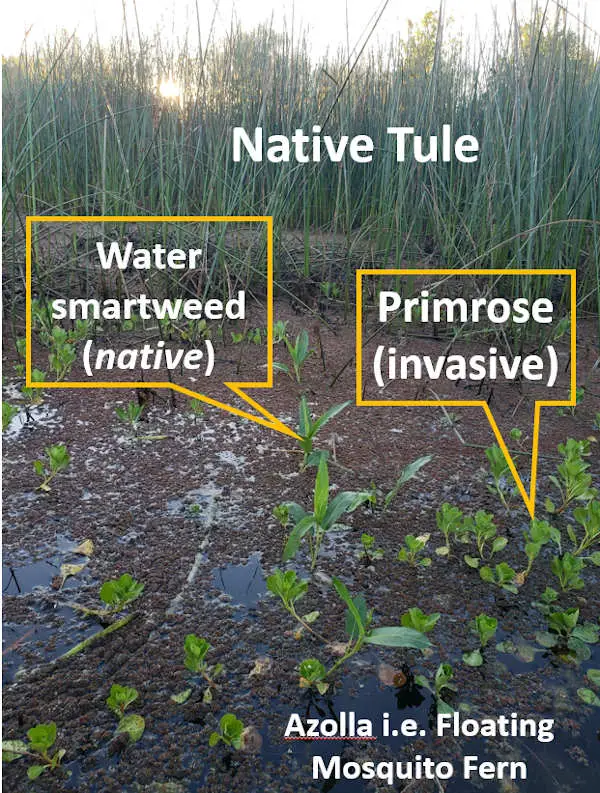
Primrose growing in a channel in Lake County, California. Courtesy photo.
Dear Lady of the Lake,
I have a timeshare on a channel on Clear Lake. This year with the low water, there is a bright green vine-like plant that is growing across the channel and taking over everything. I have enclosed a photo. Can you tell me what this is and will it go away when the water comes back?
— Paulo
Dear Paulo,
Seems like you are pretty peeved about Primrose and I don’t blame you! Based on the description and photo you provided, this nuisance invasive plant you are asking about is commonly called creeping water primrose, yellow water primrose, or marsh purslane. it’s scientific name is Ludwigia peploides. There is another variety of primrose that is almost identical called Ludwigia hexapetala, also commonly just referred to as marsh purslane, creeping primrose, Uruguay water primrose, or six-petaled primrose (although not all specimens have six-petals). Both of these have been found in abundance in Lake County and around Clear Lake.
Both creeping water primrose species are labeled by Cal-Flora and California Invasive Plant Council (Cal-IPC) high risk rating for invasiveness.
This plant is definitely a nuisance, but it’s origin and status is unclear depending on the source you are using. Some sources, such as the Jepson Manual, consider these plants “naturalized” as they are found all over the Americas, both north and South. This source also considers this plant an invasive weed. The US Department of Agriculture's Invasive Species Compendium (ISC) labels this plant a noxious weed. In many lakes and wetlands Primrose is just another member of the aquatic plant and wetland plant community. However, in other places, like Clear Lake, primrose is a very competitive, aggressive and destructive invasive that displaces native, beneficial wetland plants like tules, smartweed, spike-rush, and native sedges.
Primrose, when it grows densely in a water-way can clog water intakes, restrict boat access and navigation, prevent recreational access, trap fishing lures and lines, and in some cases dense primrose creates the stagnant water conditions that promote West Nile Mosquito habitat.
Primrose. Photo by Angela De Palma-Dow. Description
Invasive primrose is a herbaceous perennial (comes back every year from the same roots). Commonly found in wetland or riparian areas such as shorelines, mud flats, creeks, river edges, wetlands, and marshy areas. This plant will creep along the water surface, hence the “creeping” reference in its common name, but the plant has to root from the shoreline and creeps over the surface of the water. It doesn’t rise up from the water like tules or water lilies do.
The leaves are bright green around 3- 5 inches and can be slender and pointed like a lance with early or younger leaves round or egg-like. The leaves are hairless, and found on a stalk 1-2 inches long. The stem of primrose can grow indefinitely through the summer; I have pulled stems from the water up to 3 meters long.
These plants creep along and grow like strawberries; they send down shoots from the creeping stems that go into the ground so when the plant dies at the end of the season, those roots are ready to grow new growth the next season. It’s perfectly engineered to grow very successfully. This makes it the perfect invasive.
According to Cal-Flora, primrose has a heat tolerance of 95 degrees, but it’s very evident that it can tolerate the months of 100+ degree weather we have been having here. In fact, even without aquatic shorelines this year around Clear Lake due to the drought and record-low water levels, the creeping water primrose seems to be very resilient!
During the summer with low water levels and extreme heat, the tules, as well as other shoreline species, are showing signs of heat and drought stress. However, the creeping primrose seems to be doing just fine! In fact, as you observed Paulo, the primrose is using the drought and low water to its advantage and growing in the empty space provided by the low water levels. Researchers have found that overall warmer climates favor the seedling viability, the germination success, and the biomass of seeds produced in introduced primrose in California and France (Gillard et al. 2018). Again, this is a life history characteristic that makes this plant and excellent and effective invasive species.
So while the drought seems to be benefiting this species, it also grows very well in wet and high-water conditions. I think the primrose growing in the middle of a channel, for example, will not necessarily grow when the channel is under 5-10 feet of water next year, but the shoreline primrose and it’s roots are very much still viable along the shoreline and very capable of creeping into and across the channel throughout the next summer season.
Management and mitigation options
As a lake manager, primrose is one of the most frustrating species that I am trying to manage on Clear Lake. Complete eradication is probably not a feasible goal, so control and maintenance is the more likely strategy for management. This strategy is very expensive and requires consistent and regular effort. Every year more primrose can grow, and every year it has to be actively managed.
Invasive plant management science is a broad and burgeoning field, as new species and newly observed characteristics are constantly adding to the knowledge and field of research. Basically, there are more species and more issues than there are available research funds and researchers. Every system and ecosystem responds differently to the introduced invasive species and potential treatments. Sometimes, a treatment shown to be highly effective in the lab setting is less than successful in the field in real-life applications. That makes management difficult, especially when the options are all very expensive, such as herbicide chemicals or labor intensive manual removal.
For private properties and homeowners that live along Clear Lake shoreline and connected channels and canals, there are management options through the Clear Lake Integrated Aquatic Plant Management Program. With the right permits and instructions, you can manually remove the primrose from your shoreline zone, or you can hire a professional licensed herbicide applicator to chemically treat the primrose on your shoreline.
There is also a local diver company that can manually pull the primrose from your shoreline by hand, but this is most effective when the water level is high enough that the plant is actively growing in the water. This last option is very effective, but most effective for smaller shoreline properties.
There are pros and cons to every treatment option, but for an effective removal that can last, both chemical or manual treatments need to be implemented for several years consecutively in a row to remove the seedbank and any remaining fragments or roots.
If you have property on Clear Lake or just want to learn more about primrose ecology and management, the County of Lake Water Resources Department is hosting a free, virtual webinar on primrose at noon on Friday, Aug. 27. The event flyer is provided below.
Sincerely, Lady of the Lake
Angela De Palma-Dow is a limnologist (limnology = study of fresh inland waters) who lives and works in Lake County. Born in Northern California, she has a Master of Science from Michigan State University. She is a Certified Lake Manager from the North American Lake Management Society, or NALMS, and she is the current president/chair of the California chapter of the Society for Freshwater Science. She can be reached at This email address is being protected from spambots. You need JavaScript enabled to view it. .
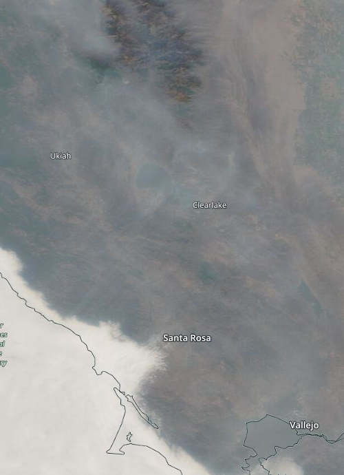
Heavy smoke is shown in the air of Northern California on Friday, August 20, 2021. Image by NASA Worldview. LAKE COUNTY, Calif. — Lake County has continued to experience smoky skies this week due to regional wildland fires and the Cache fire in Clearlake, but conditions are expected to begin to improve over the weekend.
The Lake County Air Quality Management District said the air basin continues to be impacted.
Calmer winds along with relatively stable air have settled over the region. The district said the lack of mixing and westerly winds resulted in all areas of Lake County experiencing intermittent air quality impacts from “unhealthy for sensitive groups” to “hazardous” on Friday.
For Saturday, the air quality forecast will range from “unhealthy for sensitive groups” (Air Quality Index of 101 to 150) to “unhealthy” (AQI of 151-200) with areas at higher elevations experiencing the most smoke impact.
The district said current weather models indicate that there will be some smoke clearing on Saturday and significant clearing on Sunday. Most areas should reach the “moderate” or “good” thresholds.
The National Weather Service forecast calls for widespread haze during the day on Saturday, with clearer conditions at night and on Sunday as light winds move over the area.
Visit the Lake County Air Quality Management District’s website and follow the Quick Links for Air Monitoring for current smoke and air quality conditions.
LAKE COUNTY, Calif. — The city of Clearlake on Sunday gave an update on plans for repopulating the Cache fire area.
City Manager Alan Flora said limited access to the evacuated area, zone CLE-E157-A will be provided to residents Sunday from 5 to 7 p.m.
Flora said this will facilitate some repopulation of homes not damaged or destroyed by the fire, including those residents living east of Cache Creek Mobile Home Park on Dam Road.
Absent further developments, the evacuation order for zone CLE-E157-A will be lifted on Monday at 8 a.m., Flora said.
Following the lifting of the evacuation order, Flora said a new emergency directive will go into effect restricting access within certain areas of the footprint of the fire that sustained significant damage. This order will restrict non-resident access to certain parcels and closes certain streets to traffic.
There are many hazardous substances present amongst the burned debris that may constitute a serious risk to health and safety, the city said.
All persons entering the area are encouraged to use extreme caution and those with medical conditions that could be exacerbated by the hazards should avoid the area. Residents surveying damage, particularly within the areas with total structure loss, should wear a particulate mask and gloves and avoid ground disturbances that could make the ash go airborne.
The city is actively working with county and state partners regarding initial hazardous waste cleanup. Those requested resources are anticipated to become available this week.
Additional information will be provided in the coming days, officials said.
For those residents who will be returning to the Cache Creek Mobile Home Estates, the water system was severely impacted and there is no water service.
A temporary water connection is being established but is not expected to be completed until Tuesday. If you chose to re-populate with the lifting of the evacuation order, plan accordingly for the lack of water in the coming days, officials said.
Showering, restroom facilities, and a limited supply of drinking water are available at the temporary evacuation shelter at the Clearlake Senior Community Center, located at 3245 Bowers Ave. in Clearlake.
While a significant amount of work has been completed with respect to removing burned/dangerous trees, repairing electrical and other utility infrastructure, there is more work that will be completed in the coming days. Please drive with caution and be mindful of the utility workers.
Additionally, there will be a presence of firefighters in the area monitoring for hotspots.
The city of Clearlake and the Lake County Fire Protection District said they appreciate the cooperation and support of the Clearlake community in this trying time. Officials said they will continue to update community members on the recovery status.
Maureen C Kennedy, University of Washington; Don McKenzie, University of Washington, and Jeremy Littell, US Geological Survey
The Creek Fire burns near Shaver Lake, Calif., in the Sierra Nevada in September 2020. AP Photo/Noah Berger
There is abundant evidence that changes in the climate, both increased temperature and reduced precipitation, are making wildfires worse in the western U.S. The relationship between climate and wildfire seems obvious and universal: hotter + drier = more and worse wildfire.
Yet the diversity of wildland areas in the western U.S. means that not all ecosystems respond in the same way to a hotter and drier climate. Understanding how and why climate change has different effects on wildfire is essential for effective management of our natural areas.
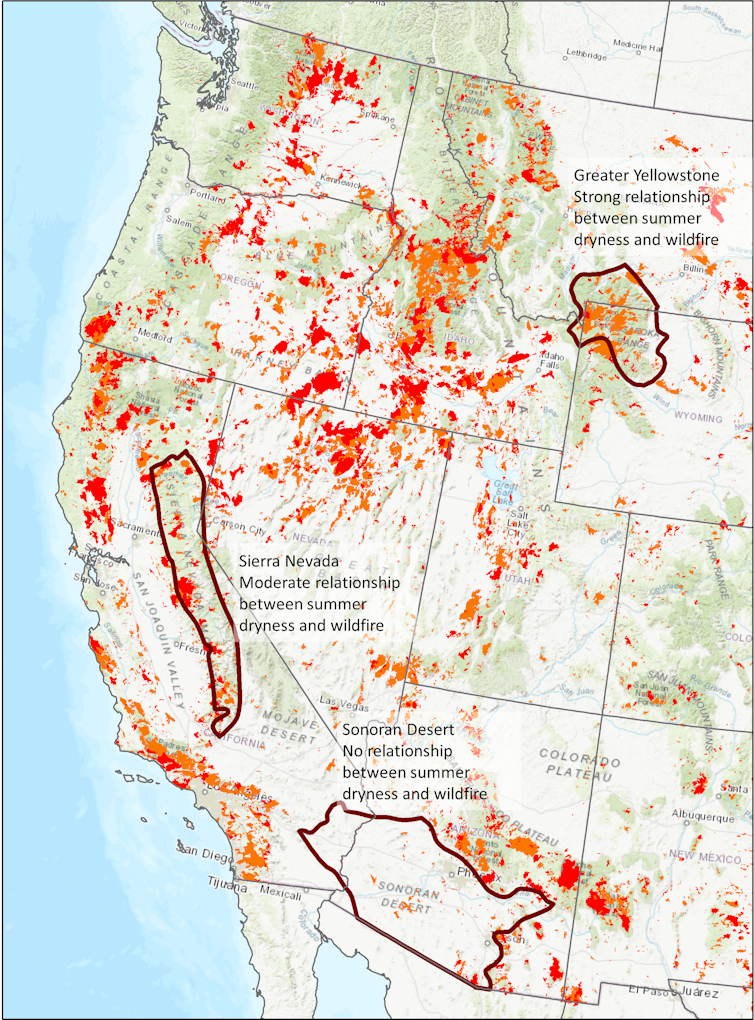
All wildfires over about 12 acres in size from 1984-2019. Red indicates fires from 2010-2019.Jeremy Littell
Why do areas respond differently?
Similar to campfires, wildfires require fuel to burn: parts of trees and shrubs, the leaves, twigs and branches. Dried grasses, too, will work. The growth of this vegetation depends on water, and water availability depends on the climate.
How hot and dry the climate is in an area influences the amount of fuel that is available to burn and the strength of the relationship between wildfire and climate. Ecologistssuch asus calculate how closely related wildfire area burned is to how hot and dry it is during the summer, and we have found that the relationship does indeed vary.
Areas that are historically cool and wet have a lot of fuel, but the fuel has to be dry enough to burn, so the relationship in these areas between wildfire and climate is very strong. Areas that are historically warm and dry have less fuel, often not enough fuel for a large wildfire even if it is very dry.
Let’s consider one extreme. The Sonoran Desert in Arizona is persistently hot and dry, and vegetation is sparse. The dryness of the summer, what we call the “summer water deficit,” does not control the extent and severity of wildfires. Summer is almost always hot and dry enough to burn, and how much it burns depends on the amount of fuel. No matter how much hotter and drier the climate becomes, wildfire is not going to increase unless more fuel appears on the landscape. Unfortunately, exotic grasses that are adapted to wildfire are invading much of the American Southwest, including the Sonoran Desert, providing that extra fuel.
At the other extreme are mountain forests, such as Yellowstone National Park and the surrounding area, that have abundant vegetation and fuel and are cooler and wetter. There, the amount of land that burns is strongly related to the summer water deficit. Hotter and drier summers are likely to increase wildfire activity.
What about areas in between these two extremes?
Where hotter and drier can eventually mean less fire
In California, wildfires in the dry forests of the Sierra Nevada are partly controlled by summer water deficit. For a while, hotter and drier summers are likely to increase the amount of land burned each year.
We ran computer simulations of the interactions among climate, plant growth and wildfire for one area within the Sierra Nevada. In the first decade of the simulations, an initial burst of large areas burned each year. This first pulse of wildfire burned more area in a scenario with increased drought and temperature than in the historical climate, just as we are seeing in the recent extreme fire seasons in the Sierra Nevada.
Over time, however, climate change will modify how plants grow. Persistently hotter and drier climate over decades will increase the number of dead and dying trees and decrease new growth. Eventually less fuel is available to burn as the dead trees decompose and fewer live ones replace them.
The same computer simulations show that the initial pulse of wildfires removes a lot of dense vegetation, and subsequent fires become smaller compared with fires in historical climate conditions and with increased drought and temperature. Furthermore, because hotter and drier conditions can eventually lead to less fuel development, the wildfire area burned over 60 years may be smaller with increased drought and temperature than in the historical climate.
Less wildfire due to climate change may sound like good news, but how it occurs is not necessarily a desirable outcome for these forests. In the simulations, reduced wildfire is a consequence of extreme water limitation that results in reduced forest biomass. This means less tree growth and more dying trees that eventually result in a thinner and less productive forest. If the climate changes enough, the trees may even be replaced by shrubs, which have their own unique relationship between climate and wildfire.
Some fires are started by lightning, but Indigenous peoples burned the landscape frequently, reducing fuels, so the spread and intensity of subsequent wildfires was more limited. After European colonization, the U.S. government spent more than a century actively suppressing wildfires. As a result, many forests became choked with excess fuels. Even without climate change, excess fuels increase the wildfire hazard.
The effect of that fire suppression on current wildfire hazards can also vary from region to region.
In cooler and wetter areas, climate change can have a stronger effect on wildfires than fire suppression. These are the areas with naturally abundant fuel and strong relationships between climate and wildfire. In drier systems, where fuels were historically low and had limited wildfire spread, suppression over the past century can have a stronger effect on current wildfire hazard than in wetter areas. It is important to consider climate change, regional characteristics and land management, all of which affect the fuels that are available to burn in a wildfire.
What to do about wildfire
There is no single solution to the increasing wildfire activity and declining health of forests.
The global solution would be to slow and eventually reverse climate change. More locally, combining prescribed fires, which are intentionally set in relatively mild weather conditions, with mechanical removal of small trees and ground fuels is the best way to prevent more severe wildfires.
Increasing the use of prescribed fire or allowing wildfires to burn under safe conditions can restore some forests to be more resilient – those that have excess fuel from fire suppression – and reduce the hazards that the western U.S. is seeing now. Past wildfires can limit the spread of new wildfires by reducing the amount of vegetation and fuel available to burn.
Wildfire burn perimeters near Yosemite National Park, Calif., 2000-2019. The largest is the 2013 Rim Fire. MTBS
Over the past five years, wildfires in the U.S. burned an average of 7.8 million acres annually, which cost an average of US$2.4 billion per year to fight.
Managing forests in the face of the threat of larger, more severe wildfires in a warming climate presents a huge challenge to fire managers, given the costs of treatments and the millions of acres that could benefit from them. Plenty of wildland is still primed to burn, and understanding the intricate relationship among climate, fuels and wildfire can help managers prioritize areas where more fire will be beneficial and areas where different approaches may be preferred.
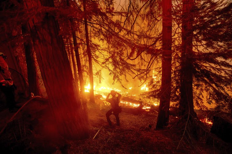
The Dixie fire in Northern California. Photo courtesy of the California Department of Fish and Wildlife. The USDA Forest Service has announced the temporary closure of nine national forests in northern California effective Sunday, Aug. 22, at 11:59 p.m. through Monday, Sept. 6 at 11:59 p.m. due to extreme fire conditions.
A 10th forest, the El Dorado National Forest, was closed earlier this week due to wildfire.
In response, the California Department of Fish and Wildlife, or CDFW, will close seven of its properties that lie within or immediately adjacent to USDA Forest Service boundaries during this same period to support emergency response routes, firefighting efforts and protect public safety.
“We understand these closures — even temporary — will significantly impact our hunters, especially with archery deer seasons opening this weekend in many parts of northern California,” said CDFW Director Charlton H. Bonham. “We have a public safety emergency and an environmental crisis on our hands with these wildfires. We thank hunters, anglers and others who cherish these public lands for respecting these closures and allowing firefighters and public safety personnel to secure these areas and help protect our wild places and our rural communities.”
Hunters are urged to check directly with the appropriate land agency about any wildfire-related closures before heading out on hunting trips.
Unfortunately, resident deer tag fees are nonrefundable regardless of land closures due to fire, weather or other natural disasters per the California Code of Regulations, Title 14, Section 708.2(b).
Refunds may be issued to nonresident tag holders (subject to specific requirements) and for select elk, pronghorn antelope and bighorn sheep tags.
Bonham said CDFW is evaluating options to petition the California Fish and Game Commission to refund deer tag fees — and other big game tag fees — for those areas closed due to wildfire conditions.
Land closures announced this week are temporary. California’s deer seasons are just beginning to open. Many of California’s general seasons are still a month or more away from opening.
“Our hope, certainly, is that deer hunters will have the opportunity to hunt at some point and participate in part or all of their favorite seasons,” Bonham said. “But we also are prepared to support our deer, elk, pronghorn and sheep hunters who have done so much for conservation over the years.”
Premium deer tags awarded using a first choice in California’s Big Game Drawing, elk tags, pronghorn antelope tags, and bighorn sheep tags may be returned to CDFW with a request to have preference points reinstated and one preference point awarded for the species for the current hunt year.
To be considered for preference point reinstatement, the tag must be returned (postmarked) prior to the first date the tag is valid for hunting.
Premium deer tags cannot be exchanged, but any hunter that has only been issued one deer tag during the hunting license year may purchase one additional deer tag from the list of available deer tags (PDF).
A complete list of tag return deadlines along with additional information on tag returns, exchanges and preference point eligibility requirements can be found on CDFW’s Hunting Licenses and Tags webpage.
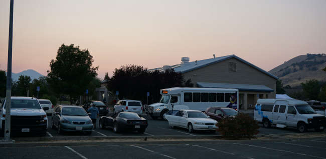
A Lake Transit bus and evacuee vehicles parked at the senior and community center in Clearlake, California, on Saturday, August 21, 2021. Photo by Elizabeth Larson/Lake County News. CLEARLAKE, Calif. — On Saturday night, a small group of people hard hit by the Cache fire were taking refuge at a newly opened evacuation shelter in Clearlake and voicing their gratitude at being alive in the midst of having lost their homes.
Clearlake city officials worked with the Red Cross to set up the shelter at the city’s senior and community center at 3245 Bowers Ave.
The center — equipped with solar power, a large commercial kitchen and a shower trailer with four bathroom stalls — also had an area set up outside for pets. There were several small dogs on leashes and in kennels.
The evacuation shelter had previously been located at Kelseyville High School and Twin Pine Casino in Middletown.
Evacuee Christina Thomas said they were told Saturday afternoon they were leaving the casino.
By Saturday evening, a Lake Transit bus that had apparently helped transport some evacuees was in the parking lot behind the building and more evacuees were arriving by their own vehicles, packed with what belongings they had left.
As the shelter setup was complete, a bright, smoky-orange sun set behind Mount Konocti, which was soon followed by a bright orange full moon that rose over the hills.
As shelter guests got their bearings, some took the opportunity for the first time in days to get a hot shower before settling in for the night.
Shelter officials said they were set up for 20 evacuees, with about 16 registered.
After several days of exhaustion and confusion, even with the lights on and shelter workers moving around the building to finish setup, some evacuees were on their cots, fast asleep amid the bustle.
Tucked off in the corner, sitting on his cot next to a window in the main room was Gust Jordan, who gave a friendly wave.
He was wearing a large wooden rosary around his neck, a Red Cross blanket next to him, and bags of snacks and Red Cross supply bags on the floor next to his bed. The beds arranged nearby were for several of his family members.
Jordan, who formerly worked in agriculture in Tulare County, moved to Clearlake a year ago. He was living with wife, Christina, one of their daughters and her husband and three grandchildren in a trailer in Creekside Mobile Home Park. Also living nearby were several members of their extended family.
Christina Jordan said that, altogether, her family lost five homes — including the one she and Gust shared, one belonging to her parents, and three others belong to aunts and uncles.
Her aunt, Christina Thomas, who lived in Creekside for 10 years, was the only one whose home survived.
At first, they weren’t sure if they should leave because of the fire. “We did this so many times,” Gust Jordan said of previous fires, noting this felt like another situation of crying wolf.
However, shortly after the fire started, it became apparent that they needed to leave.
Christina Jordan said the fire moved very fast. “It was so windy,” she said, noting her uncle told her they needed to leave.
Gust Jordan said his wife grabbed a box of important papers as they prepared to leave. In their quick departure, they didn’t take his medications or other important items.
The residents were all in a hurry to get out of the park. “Everybody was jumping in their cars,” said Thomas.
Police escorted them out. “They were not asking,” but telling them to leave, Gust Jordan said.
By the time they were leaving, the fire had jumped the road, he said.
They and other family members did what many other evacuees did — they went to the nearby Walmart to wait and see what was happening.
Asked how long they’ll have to stay at the shelter, he said, “I have no idea.”
The Jordans said their daughter and her family were staying in a hotel, rather than the shelter.
Christina Jordan’s parents, Richard and Yolanda Maldonado, also were staying at the shelter on Saturday.
Richard Maldonado said their home was destroyed, and he’s now seeking help with finding housing from the Department of Veterans Affairs. He served in the US Marine Corps from 1956 to 1959.
The Maldonados had lived at Creekside Mobile Home Park for the last two years, and had also lived there previously. Richard Maldonado said they had been evacuated in 2015 due to that year’s fires.
He said they had to evacuate within 20 minutes of the Cache fire starting.
That wasn’t an easy task, as Richard Maldonado currently has to use a wheelchair.
The Maldonados also went to Walmart to wait to see what was going to happen. They were there about an hour to an hour and a half before they were directed to Kelseyville High School, where an evacuation shelter was set up shortly after the fire began.
They and their other family members stayed there until they were told to move to Twin Pine Casino in Middletown on Thursday. Gust Jordan said he lost $40 at the casino. However, he happily recalled a visit from Pastor Aaron York of Jesus Christ Fellowship.
By Saturday afternoon, they were told they were to move again, family members said.
On Saturday night, none of the family members had an idea of how long they would have to stay at the shelter.
In addition to the uncertainty, there is also the emotional toll.
“I don’t think I got any feelings yet,” Richard Maldonado said of the situation, adding he was glad everyone got out alive.
Thomas said that since her home still stands, she intends to share it with her family. “That’ll work.”
“We’re alive,” Christina Jordan said. “That’s all that matters.”
Email Elizabeth Larson at This email address is being protected from spambots. You need JavaScript enabled to view it.. Follow her on Twitter, @ERLarson, or Lake County News, @LakeCoNews.
A new video rings in the rover’s ninth year on Mars, letting viewers tour Curiosity’s location on a Martian mountain.
Images of knobbly rocks and rounded hills are delighting scientists as NASA’s Curiosity rover climbs Mount Sharp, a 5-mile-tall mountain within the 96-mile-wide basin of Mars’ Gale Crater.
The rover’s Mast Camera, or Mastcam, highlights those features in a panorama captured on July 3, 2021 (the 3,167th Martian day, or sol, of the mission).
This location is particularly exciting: Spacecraft orbiting Mars show that Curiosity is now somewhere between a region enriched with clay minerals and one dominated by salty minerals called sulfates.
The mountain’s layers in this area may reveal how the ancient environment within Gale Crater dried up over time. Similar changes are seen across the planet, and studying this region up close has been a major long-term goal for the mission.
“The rocks here will begin to tell us how this once-wet planet changed into the dry Mars of today, and how long habitable environments persisted even after that happened,” said Abigail Fraeman, Curiosity’s deputy project scientist, at NASA’s Jet Propulsion Laboratory in Southern California.
Nine years on Mars
Curiosity landed nine years ago, on Aug. 5, 2012 PDT (Aug. 6, 2012 EDT), to study whether different Martian environments could have supported microbial life in the planet’s ancient past, when lakes and groundwater existed within Gale Crater.
The rover pulverizes rock samples with a drill on its robotic arm, then sprinkles the powder into the rover’s chassis, where a pair of instruments determines which chemicals and minerals are present.
Curiosity recently drilled its 32nd rock sample from a target nicknamed “Pontours” that will help detail the transition from the region of clay minerals to the one dominated by sulfates.
Because it’s winter at Curiosity’s location, the skies in the new panorama are relatively dust-free, providing a clear view all the way down to Gale Crater’s floor. It’s provided an opportunity for the mission team to reflect on the 16 miles Curiosity has driven during the mission.
“Landing day is still one of the happiest days of my professional career,” said the mission’s new project manager, Megan Richardson Lin of NASA’s Jet Propulsion Laboratory in Southern California. Lin started working on Curiosity just before it launched, joining the surface operations team shortly afterward. She’s held several roles on the mission since then. “We’re driving a robot as it explores another planet. Seeing how new discoveries and scientific results guide each day’s activities is extremely rewarding.”
There’s more to discover on the road ahead. Curiosity has already started up a path winding between “Rafael Navarro Mountain,” recently nicknamed to honor a deceased mission scientist, and a towering butte that’s taller than a four-story building.
In the coming year, the rover will drive past these two features into a narrow canyon before revisiting the “Greenheugh Pediment,” a slope with a sandstone cap that the rover briefly summited last year.
NORTHERN CALIFORNIA — The Bureau of Land Management Central Coast and Ukiah field offices are increasing fire restrictions due to high wildland fire danger.
The restrictions apply to all BLM-managed public lands within the boundary of the Central Coast and Ukiah field offices, which are primarily located in Colusa, western Fresno, Glenn, Lake, Marin, Mendocino, Monterey Napa, San Benito, Santa Cruz, Solano, Sonoma and Yolo counties.
The fire orders go into effect now until further notice.
The increased restrictions prohibit campfires, barbecues, or open fires on all public lands, including in developed campgrounds.
Portable stoves with gas, jelled petroleum, or pressurized liquid fuel are still allowed with a valid California campfire permit, available free online at www.readyforwildfire.org/prevent-wildfire/campfire-safety/ and at all BLM, U.S. Forest Service and Cal Fire offices.
California is in a drought with 85 percent of the state in extreme drought. Dry grass, brush and trees ignite and burn extremely quickly.
Taking individual responsibility to reduce wildland fire risk, while recreating on public lands, around homes and communities, before a fire occurs can help keep property, the public and firefighters safe.
Nearly 90% of wildfires in the United States are caused by humans. The public is advised to be extremely careful when recreating outdoors and do the following: always carry a shovel and water and check weather forecasts and fire danger ratings before leaving home.
The following restrictions/limitations are already in place and will continue to be enforced until fire dangers subside:
· No target shooting; use of firearms for hunting is still allowed.
· No smoking, except within an enclosed vehicle or building, or at a designated developed recreation site.
· No tools powered by internal combustion engines (chain saws, lawn mowers, generators, etc.) off established roads or trails.
· No motorized vehicles off established roads or trails.
· No fireworks, including “safe and sane” fireworks.
· No welding or operating acetylene or other torch with open flame, except by special permit.
LAKE COUNTY, Calif. — The Clearlake residents who have been staying at the evacuation shelter created for those who fled the path of the Cache fire on Wednesday faced another move on Saturday as the county shut down the shelter in Middletown, a move that has caused tensions between city and county officials.
The 83-acre fire, which an initial estimate said destroyed 56 homes and 81 outbuildings, started Wednesday afternoon. The worst damage was in the Creekside Mobile Home Park, where most of the homes were reported destroyed, with other nearby homes — including some in the Cache Creek Mobile Home Park — also burned to the ground.
With work still underway to put the fire out completely, residents of the Clearlake area south of 18th Avenue and east of Highway 53 except for Adventist Health Clear Lake Hospital remained unable to return home on Saturday due to a continuing mandatory evacuation order
While city officials said they hope residents will be able to repopulate that area by Sunday, it’s not yet clear if that will happen due to the amount of tree removal and utility infrastructure that needs to be completed to make it safe.
In the meantime, in the days since the fire several dozen evacuees had been reported to be staying at the evacuation shelter.
That sheltering has been critical for many. The reason, as pointed out by City Manager Alan Flora, is that the fire area was home to some of the community’s poorest members.
The shelter initially was set up on Wednesday afternoon at Kelseyville High School. On Thursday, it was moved to Twin Pine Casino in Middletown.
During Thursday night’s Clearlake City Council meeting, Councilman Russ Cremer had asked why the shelter hadn’t been located at the city’s senior and community center, which has been an evacuation shelter before — including for the Valley fire — and has undergone significant upgrades to make it ready to fulfill that purpose.
Then, on Saturday, Clearlake officials, including Mayor Dirk Slooten, said they were told that County Administrative Officer Carol Huchingson had ordered Lake County Social Services staff to leave the shelter, because it was a city emergency, not a county emergency.
“We know that county staff were pulled from the shelter at Carol’s direction this morning,” Flora said.
Flora said the county’s Social Services Department has a sheltering team that’s supposed to respond to such situations, and has done so over the past several years.
Huchingson, Social Services Director Crystal Markytan, Supervisor Moke Simon — who also is chair of the Middletown Rancheria of Pomo Indians, which owns and operates Twin Pine Casino — and Deputy County Administrative Officer Matthew Rothstein did not respond to an email from Lake County News seeking comment on Saturday.
Board Chair Bruno Sabatier, whose district includes Clearlake, said he was working with the city to coordinate with the Red Cross, which is operating the shelter at the city’s senior and community center at 3245 Bowers Ave.
He said he’d spoken to both Huchingson and Simon and was working “to ensure the people displaced by the Cache Fire are taken care of until they can return home or we find more permanent solutions for those who lost a home.”
One county official who did offer to explain the decision was Sheriff Brian Martin.
He told Lake County News that 1,600 people evacuated and that, based on previous events, they expected only about 10% to seek shelter.
At last count Martin said there were only 16 people at the shelter, and since all of the homes that were destroyed were within the city of Clearlake, it wasn’t the county’s or the tribe’s responsibility to help. The Red Cross was willing to operate a shelter at the senior center, so the shelter at Twin Pine was closed.
Martin said he didn’t know when the closure took place but said that Simon said he was giving people adequate time to transition.
“It’s not a county emergency, it’s a city emergency,” Martin said, adding the city has the obligation to handle the situation.
Martin also said there have not been any mutual aid requests from the city to the County Administrative Office that he was aware of at that time.
When asked why the county supported the city of Lakeport’s flood victims in early 2017, Martin said that was because it was considered a countywide emergency.
Another move
Gemini Garcia, a Lake County News contributor, went to Twin Pine to size up the situation midafternoon Saturday and didn’t get a kind greeting at the facility.
She said by that point there was a pop up tent and cots with a few Red Cross blankets set up in the smoky outdoor conditions in a back parking lot.
Three men were left at the casino shelter by then, with several caged small dogs plus one deceased dog waiting for Animal Care and Control to collect it, Garcia said.
She said she spoke with two of the men, who wouldn’t give their names or consent to be photographed. She said they told her that they don’t have family or friends, and no assets.
Garcia said no one could confirm to her that the shelter was moving anywhere.
Later in the afternoon, Slooten said the city was opening up the senior center and getting evacuees moved in that night.
Slooten took direct aim at Huchingson for the treatment of the city’s evacuees, saying it bordered on negligence.
He suggested Huchingson’s actions were in retaliation for an ongoing lawsuit the city has against the county for failing to put up for auction tax defaulted properties, some of them in arrears for decades, within the city.
He said many such properties are in the fire area, and a county map of tax defaulted properties in that location showed several dozen properties in that area that are behind in taxes, some for more than 30 years.
“I am very angry about it,” Slooten said of the situation.
One of the sticking points appeared to be that the city wanted to transport its shower trailer to the casino for evacuees. Flora said for some of them it had been the first time in days they had a chance to bathe. However, he said they were told the casino didn’t want to deal with the shower trailer.
Transitioning to a new location
At the shelter on Saturday night, Cremer, Flora, Councilman Russ Perdock, Sabatier and Police Chief Andrew White were continuing to work with the Red Cross to make sure the shelter was fully operational. Slooten had been there earlier in the evening for the set up.
Evacuees were able to make use of the four-stall shower trailer installed at the center, as well as another shower trailer provided by Adventist Health that Perdock was supervising.
By that point, Flora said he had spoken to Simon, who he said faulted the city for having no plan for moving forward. Flora, in turn, had to remind Simon of the city having been in the midst of the emergency response for several days.
Flora said there had been a lack of communication between the city and county — for which he said Simon apologized — although he said he was not entirely sure what to believe.
In his comments to Lake County News, Martin said there had not been mutual aid requests for help in the emergency, beyond the initial response.
“There’s been numerous requests, since the beginning,” White said when asked about Martin’s statement. “It’s an evolving situation.”
Flora said the city is looking at opening a local assistance center for fire survivors this week and considering ways to move people into other places to stay. He said they are working with state officials to get assistance for short-term housing options
White said they have made contact with virtually everyone with a home in the fire area, and continue to have no missing persons reports.
Due to the fire’s speed and the concentration of homes in the area, Flora said fatalities had been a big concern.
Next steps
The California Department of Housing and Community Development is the agency with jurisdiction over mobile home parks.
Flora said Housing and Community Development inspectors were at the scene on Thursday.
The State Department of Toxic Substances Control has agreed to send a hazmat team to work on mitigations for ash laden with heavy metals, especially around Cache Creek. However, Flora said the state requires the county to declare a health emergency first.
The Board of Supervisors’ Tuesday agenda so far does not have that item included. Flora said it’s his understanding that the acting Public Health officer will make the declaration on Monday and the board will ratify it on Tuesday.
Beyond that help from the state, the city is still facing the potential to have to shoulder the recovery largely on its own due to not meeting state and federal damage thresholds, which would qualify it for emergency assistance.
The city does, however, have notable allies as it seeks help, including Assemblywoman Cecilia Aguiar-Curry and state Sen. Mike McGuire, both of whom have supported Lake County and its communities in previous disasters.
There was another hopeful note at the shelter on Saturday night as well.
Kevin Cox of Hope City, who has been involved in rebuilding homes in the south county that were destroyed in the Valley fire, was at the site to offer support to city officials.
His organization completed its Middletown work earlier this year and is now working in Paradise on Camp fire recovery.
Cox and his 12-person staff have assisted 26,000 families across the country in getting back into homes after fires.
Cremer said Cox was one of the first people who he spoke to this week as the city begins to grapple with its own rebuilding process.
Email Elizabeth Larson at This email address is being protected from spambots. You need JavaScript enabled to view it.. Follow her on Twitter, @ERLarson, or Lake County News, @LakeCoNews.
LAKE COUNTY, Calif. — Clearlake officials are working to put together solutions to carry out the recovery needed due to the Cache fire, which firefighters are continuing to work to fully contain.
The fire, burning since Wednesday afternoon, remained at 83 acres on Friday, with containment up to 45%, said Lake County Fire Chief Willie Sapeta.
Early Saturday, one zone in Lake County’s Zonehaven system remained under mandatory evacuation, Zone CLE-E157, which contains everything in the city of Clearlake to the south of 18th Avenue and east of Highway 53 except for Adventist Health Clear Lake Hospital.
City Manager Alan Flora said he visited the fire scene on Friday morning and there were a few hotspots to deal with but little fire activity.
He said the hope is that evacuees can return home on Sunday, but added that a lot of work by Pacific Gas and Electric to replace damaged power infrastructure remains to be done.
Overall, Sapeta — who was one of the first on scene at the incident, which is estimated to have destroyed 137 structures, including 56 homes — said the progress on the fire was “looking good.”
What’s not looking good is the prospects for the city of Clearlake to get help in the complex task of recovery.
City officials have acknowledged that because the fire doesn’t meet the thresholds for state and federal disaster assistance — as has been the case with most of Lake County’s destructive fires — much of the multimillion dollar recovery process and its cost could end up falling on the city.
Flora said the state is going to provide very limited resources to the city for the incident.
He said the city will get a hazmat team from the Department of Toxic Substances Control, which is waiting on the county of Lake to declare a public health emergency so the phase one cleanup can begin.
“Hopefully that will be soon,” said Flora.
As of Friday, that public health emergency had not been agendized by the Board of Supervisors for its next meeting on Tuesday.
Flora said the state hazmat team won’t address any debris clean up from homes or vehicles.
He said the city is working with Assemblywoman Cecilia Aguiar-Curry and Sen. Mike McGuire to try to piece together a solution or the cleanup, but he said so far they have no solid plan.
“We are still working to see if we can get any short term housing assistance for those that lost their homes, but nothing happening yet from the state on that front,” Flora said.
He also didn’t have a dollar estimate for damage.
Flora said that estimate has to be submitted by the California Office of Emergency Services by Wednesday, “so it will start coming together soon.”
Email Elizabeth Larson at This email address is being protected from spambots. You need JavaScript enabled to view it.. Follow her on Twitter, @ERLarson, or Lake County News, @LakeCoNews.
Kevin Trenberth, National Center for Atmospheric Research
July 2021 was Earth’s hottest month on record and was marked by disasters, including extreme storms, floods and wildfires. Thomas Lohnes via Getty Images
Climate change has been accumulating slowly but relentlessly for decades. The changes might sound small when you hear about them – another tenth of a degree warmer, another centimeter of sea level rise – but seemingly small changes can have big effects on the world around us, especially regionally.
The problem is that while effects are small at any time, they accumulate. Those effects have now accumulated to the point where their influence is contributing to damaging heat waves, drought and rainfall extremes that can’t be ignored.
The most recent report from the United Nations’ Intergovernmental Panel on Climate Change is more emphatic than ever: Climate change, caused by human activities like burning fossil fuels, is having damaging effects on the climate as we know it, and those effects are rapidly getting worse.
Earth’s energy imbalance
An excellent example of how climate change accumulates is Earth’s energy imbalance. I am a climate scientist and have a new book on this about to be published by Cambridge University Press.
The Sun bombards Earth with a constant stream of about 173,600 terawatts (that is 12 zeros) of energy in the form of solar radiation. About 30% of that energy is reflected back into space by clouds and reflective surfaces, like ice and snow, leaving 122,100 terawatts to drive all the weather and climate systems around us, including the water cycle. Almost all of that energy cycles back to space – except for about 460 TW.
That remaining 460 TW is the problem we’re facing. That excess energy, trapped by greenhouse gases in the atmosphere, is heating up the planet. That is the Earth’s energy imbalance, or in other words, global warming.
Outgoing radiation is decreasing, owing to increasing greenhouse gases in the atmosphere, and leading to Earth’s energy imbalance of 460 terawatts. The percentage going into each domain is indicated.Kevin Trenberth, CC BY-ND
In comparison with the natural flow of energy through the climate system, 460 TW seems small – it’s only a fraction of 1 percent. Consequently, we cannot go outside and feel the extra energy. But the heat accumulates, and it is now having consequences.
To put that in perspective, the total amount of electricity generated worldwide in 2018 was about 2.6 TW. If you look at all energy used around the world, including for heat, industry and vehicles, it’s about 19.5 TW. Earth’s energy imbalance is huge in comparison.
Interfering with the natural flow of energy through the climate system is where humans make their mark. By burning fossil fuels, cutting down forests and releasing greenhouse gases in other ways, humans are sending gases like carbon dioxide and methane into the atmosphere that trap more of that incoming energy rather than letting it radiate back out.
Before the first industries began burning large amounts of fossil fuels in the 1800s, the amount of carbon dioxide in the atmosphere was estimated at around 280 parts per million of volume. In 1958, when Dave Keeling began measuring atmospheric concentrations at Mauna Loa in Hawaii, that level was 310 parts per million. Today, those values have climbed to about 415 parts per million, a 48% increase.
Carbon dioxide is a greenhouse gas, and increased amounts cause heating. In this case, the human increment is not small.
Where does the extra energy go?
Measurements over time show that over 90% of this extra energy is going into the oceans, where it causes the water to expand and sea level to rise.
The upper layer of the oceans started warming around the 1970s. By the early 1990s, heat was reaching 500 to 1,000 meters (1,640 to 3,280 feet) deep. By 2005, it was heating the ocean below 1,500 meters (nearly 5,000 feet).
The average global temperature change at different ocean depths, in zetajoules, from 1958 to 2020. The top chart shows the upper 2,000 meters (6,561 feet) compared with the 1981-2010 average. The bottom shows the increase at different depths. Reds are warmer than average, blues are cooler.Cheng et al, 2021, CC BY-ND
Global sea level, measured by flights and satellites, was rising at a rate of about 3 millimeters per year from 1992 to 2012. Since then, it been increasing at about 4 millimeters a year. In 29 years, it has risen over 90 millimeters (3.5 inches).
If 3.5 inches doesn’t sound like much, talk to the coastal communities that exist a few feet above sea level. In some regions, these effects have led to chronic sunny day flooding during high tides, like Miami, San Francisco and Venice, Italy. Coastal storm surges are higher and much more destructive, especially from hurricanes. It’s an existential threat to some low-lying island nations and a growing expense for U.S. coastal cities.
Some of that extra energy, about 13 terawatts, goes into melting ice. Arctic sea ice in summer has decreased by over 40% since 1979. Some excess energy melts land ice, such as glaciers and permafrost on Greenland, Antarctica, which puts more water into the ocean and contributes to sea level rise.
Some energy penetrates into land, about 14 TW. But as long as land is wet, a lot of energy cycles into evapotranspiration – evaporation and transpiration in plants – which moistens the atmosphere and fuels weather systems. It is when there is a drought or during the dry season that effects accumulate on land, through drying and wilting of plants, raising temperatures and greatly increasing risk of heat waves and wildfire.
Consequences of more heat
Over oceans, the extra heat provides a tremendous resource of moisture for the atmosphere. That becomes latent heat in storms that supersizes hurricanes and rainstorms, leading to flooding, as people in many parts of the world have experienced in recent months.
Air can contain about 4% more moisture for every 1 degree Fahrenheit (0.55 Celsius) increase in temperature, and air above the oceans is some 5% to 15% moister than it was prior to 1970. Hence, about a 10% increase in heavy rain results as storms gather the excess moisture.
Again, this may not sound like much, but that increase enlivens the updrafts and the storms, and then the storm lasts longer, so suddenly there is a 30% increase in the rainfall, as has been documented in several cases of major flooding.
Cyclone Yasa heads for Fiji in December 2020. It was the fourth most-intense tropical cyclone on record in the South Pacific.NASA Earth Observatory
In Mediterranean climates, characterized by long, dry summers, such as in California, eastern Australia and around the Mediterranean, the wildfire risk grows, and fires can be readily triggered by natural sources, like dry lightning, or human causes.
Extreme events in weather have always occurred, but human influences are now pushing them outside their previous limits.
The straw that breaks the camel’s back syndrome
So, while all weather events are driven by natural influences, the impacts are greatly magnified by human-induced climate change. Hurricanes cross thresholds, levees break and floods run amok. Elsewhere, fires burn out of control, things break and people die.
I call it “The straw that breaks the camel’s back syndrome.” This is extreme nonlinearity, meaning the risks aren’t rising in a straight line – they’re rising much faster, and it confounds economists who have greatly underestimated the costs of human-induced climate change.
The result has been far too little action both in slowing and stopping the problems, and in planning for impacts and building resilience – despite years of warnings from scientists. The lack of adequate planning means we all suffer the consequences.
[The Conversation’s science, health and technology editors pick their favorite stories.Weekly on Wednesdays.]

 How to resolve AdBlock issue?