LAKE COUNTY, Calif. – This week, Congressman John Garamendi (D-Davis, Fairfield, Yuba City) sent a letter with 12 of his California Democratic colleagues to the Federal Trade Commission calling for an investigation into Verizon for slowing the download speeds of the Santa Clara County Fire Department’s “unlimited” data plan after it hit a “data cap” while it was battling the Mendocino Complex fire, the largest wildfire in California history.
Specifically, Garamendi and his colleagues are asking the FTC to determine whether Verizon’s practices were ‘unfair’ or ‘deceptive’ pursuant to Section 5 of the Federal Trade Commission Act.
“Diminishing the download speeds of data that our firefighters rely upon to coordinate and deploy resources to fight active wildfires is unconscionable. The Mendocino Complex fire is threatening numerous communities throughout my district, including Lake County, which has experienced eight wildfires over the past three years. Any delay in firefighting efforts could be a disaster for my constituents, and we must ensure our first responders have unabated access to the services they rely upon to keep our communities safe,” Garamendi said.
“I’m calling upon the FTC to investigate this matter and determine whether Verizon is misleading customers in the services they offer, and to identify remedies that can prevent events like this from occurring in the future. I would like to thank Congresswoman Eshoo for coordinating this letter, and many of my California Democratic colleagues who joined us in this effort,” Garamendi concluded.
The letter was also signed by Representatives Nancy Pelosi (CA-11), Anna Eshoo (CA-18), Mark DeSaulnier (CA-11), Jared Huffman (CA-2), Ro Khanna (CA-17), Barbara Lee (CA-13), Zoe Lofgren (CA-19), Doris Matsui (CA-6), Jerry McNerney (CA-9), Jimmy Panetta (CA-20), Jackie Speier (CA-14), and Mike Thompson (CA-5).
Sharon Foley, 67, of Kelseyville, Calif. Courtesy photo. LAKE COUNTY, Calif. – Authorities said that they have located and recovered what evidence so far suggests is the body of a woman who was reported missing from Lake County nearly two months ago.
The Ford Crown Victoria belonging to Kelseyville resident Sharon Foley, along with human remains, was discovered earlier this week on private property in a remote, forested area of Sierra County, according to Sgt. Mike Fisher of the Sierra County Sheriff’s Office.
A family member reported Foley, 67, missing to the Lake County Sheriff’s Office on July 9, six days after she was last seen.
She also had gone missing for a few days in early May but was quickly located, as Lake County News has reported.
When she was reported missing in July, the Lake County Sheriff’s Office said she suffered from depression and bipolar disorder and hadn’t been taking her medications, and that she couldn’t walk on her own, but could drive a vehicle.
Lt. Corey Paulich of the Lake County Sheriff’s Office told Lake County News that on Monday the agency was notified by the Sierra County Sheriff’s Office that a deceased female believed to be Foley was located in a rural area of that county.
Fisher, the supervising sergeant on the investigation as well as Sierra County’s sheriff-elect, said that on Monday afternoon the Sierra County Sheriff’s Office was contacted by a forester who had been doing some work on a remote piece of property in that county’s western portion.
The forester came across a white Ford Crown Victoria and thought it was suspicious. When he approached the vehicle, he found what he believed to be human remains, Fisher said.
With there being no cell service, the forester went to get the property owner and together the two of them went to find an area of cell coverage to call authorities, according to Fisher.
Fisher said he and two deputies responded out to the location, which he said is about a 40-minute drive on dirt roads to the east of Camptonville, the closest town, located in neighboring Yuba County.
Once on scene, Fisher said they were able to confirm that the vehicle was Foley’s 2009 Ford Crown Victoria – the same vehicle in which the Lake County Sheriff’s Office said she had left her home on July 3 – and matched the license plate, 6FYP475.
During their subsequent investigation of the scene, Fisher said they located human remains.
“We believe it to be that of Sharon Foley but we have not made positive identification,” he said.
Fisher said they don’t believe there was foul play. Rather, it appears that Foley’s car became stuck and she succumbed to the elements. She had been dead for some time, he added.
He said it appeared that Foley had traveled a series of Forest Service roads before turning off onto the private property.
“We run into this a little more in the winter time,” he said, noting that one of the area’s main highways on its far east side is Interstate 80 between Truckee and Reno. In those cases, if there is a highway closure, people can get off course when their GPS directs them to alternate routes through remote territory.
But that didn’t appear to be the case here, with there being no sign of a GPS, he said.
The vehicle was found on an unmaintained road that the property owner doesn’t often travel, Fisher said.
In examining the car, Fisher said Foley did not have her wheelchair with her, which she needed because she couldn’t walk. She also didn’t have a cell phone. Without the ability to walk out or to signal for help, Foley was trapped.
Fisher said the car was open, and the remains appeared to have been disturbed by animals.
The remains were sent to the Placer County Medical Examiner’s office for an autopsy. Fisher said they will essentially catalog what was recovered and collect DNA samples to confirm the identity.
The car also was removed from the scene, he said.
Fisher said Foley’s family has been notified of the discovery.
While they haven’t so far positively identified the individual, “Based on the evidence at scene, we were confident enough to give the family some closure,” Fisher said.
He said it may take another month to get DNA results back from the California Department of Justice.
If there is a delay, they will consult a forensic odontologist in the Bay Area, who will use dental records for the identification, he said.
Email Elizabeth Larson at This email address is being protected from spambots. You need JavaScript enabled to view it.. Follow her on Twitter, @ERLarson, or Lake County News, @LakeCoNews.
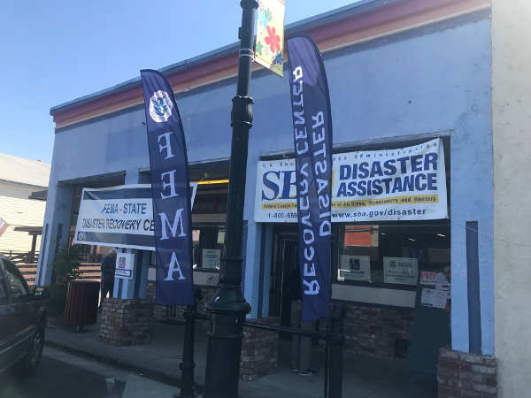
The FEMA Disaster Recovery Center in Upper Lake, Calif. Courtesy photo. UPPER LAKE, Calif. – Lake County residents affected by the Mendocino Complex fires can now access recovery and relief services and resources at the newly established Federal Emergency Management Agency Disaster Recovery Center, located at the Habematolel Pomo of Upper Lake Community Center in Upper Lake.
The Disaster Recovery Center at Habematolel of Upper Lake Community Center is the only recovery center servicing the county residents and employees and helps between approximately 80 households affected by the fires each day.
FEMA partnered with the Habematolel Pomo of Upper Lake tribal government to establish a Disaster Recovery Center in order to serve individuals devastated by the Mendocino Complex Fires.
“These services are vital for the people of Lake County who lost everything or were evacuated as a result of the Mendocino Complex fires,” said Sherry Treppa, chairwoman of the Habematolel Pomo of Upper Lake Indian tribe. “These services are only the beginning to the recovery and rebuilding efforts, and we are proud to partner with the state and federal government to help ensure resources are readily available to our local community.”
The Disaster Recovery Center is a one-stop shop for those impacted by the fires, providing an array of services including food assistance programs, clean-up assistance, grants and loans for rental assistance, home repairs and rebuilding, personal disaster-related expenses, and temporary emergency housing, as well as important document recovery.
The agencies offering services include the California Department of Human Resources, the Department of Insurance, the Contractors State License Board, the Department of Public Health, the Department of Tax and Fee Administration, the Department of Motor Vehicles, Employment Development Department, Franchise Tax Board, Department of Social Services, Lake County Behavioral Health, the American Red Cross, FEMA, the Small Business Administration and the US Department of Agriculture.
Mendocino Complex survivors who visit the center are encouraged to bring a social security number (one per household), address of the damaged home or apartment, description of the damage, information about insurance coverage, telephone number, mailing address, bank account and routing numbers for direct deposit of funds.
The Disaster Recovery Center is open from 9 a.m. to 6 p.m. Monday through Saturday, with the exception of Labor Day when the center will be closed.
Staffers helping community members at the FEMA Disaster Recovery Center in Upper Lake, Calif. Courtesy photo.
LAKE COUNTY, Calif. – As Labor Day officially signals the end of summer, Cal Fire officials are encouraging Californians to be cautious with outdoor plans this weekend as wildfire risk remains high.
With millions of people taking advantage of the holiday weekend to visit beaches, parks, and campgrounds, we need everyone to be extra vigilant in preventing wildfires.
“This year we have seen not only the largest wildfire in California history, but the largest wildfire for 2018 across the United States,” said Chief Ken Pimlott, director of Cal Fire. “The past few months, our firefighters have been extremely busy with devastating, record-breaking wildfires. This year, Cal Fire has responded to 4,434 fires that burned 876,428 acres, compared to last year when we responded to 4,170 fires for 228,803 acres. Even though we will have near-normal temperatures this weekend, vegetation across the state is extremely dry and fall is when we typically see some of the most devastating fires.”
“We need everyone to be prepared ahead of time with our Ready, Set, Go! program that helps equip residents for a wildfire,” said Lynne Tolmachoff, Cal Fire chief of public education. “As 95 percent of our wildfires are human caused, the One Less Spark, One Less Wildfire Program stresses how to prevent wildfires through proper care and maintenance of campfires, vehicles, outdoor equipment and much more.”
So, what can you do to help prevent wildfires?
Vehicles:
– Never pull over and park in dry grass. – Make sure your vehicle is properly maintained. – When towing, ensure chains are not dragging on the ground. – Check your tire pressure to avoid driving on an exposed metal rim.
Camping:
– Obtain a campfire permit and ALWAYS check for local fire restrictions. – Keep a safe distance from dead trees to avoid falling branches and limbs. – Avoid parking and setting up camp under or near dead trees. – Be careful! Human activity causes 95 percent of wildfires. – Clear away grass, leaves and other debris within a 10-foot perimeter of any campfire “Drown, stir and feel” to make sure a campfire is completely out. – When barbequing, never leave the grill unattended.
Yardwork:
– Do all yardwork before 10 a.m. – avoid yardwork on hot, dry and windy days. – Make sure you use the right tool for the job – lawnmowers are for cutting grass only.
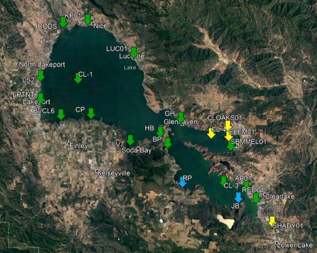
The map shows areas on Clear Lake in Lake County, Calif., where samples taken on August 15 and August 21, 2018, revealed “caution” levels for blue-green algae cyanotoxin. Image courtesy of the county of Lake and Big Valley Rancheria.
LAKE COUNTY, Calif. – Lake County Public Health reported that the latest round of testing for blue-green algae cyanotoxins on Clear Lake has resulted in “caution” levels for several areas.
Officials said current cyanotoxin results for lakewide sampling conducted Aug. 15 and Aug. 21 – which results received on Aug. 29 – detected microcystin at 12 of 21 sampled sites.
Four of those sites resulted in caution trigger levels: the center of the Oaks Arm, Clearlake Oaks shoreline, Elem shoreline and Cache Creek at Highway 53.
The remaining sites do not reach any trigger levels, were nondetect for toxins, or were not sampled due to being inaccessible, official said.
The next monitoring event will be Sept. 10.
This week's reading are lower than previously, but two consecutive improved readings are needed before the county can change the level of alert for cyanobacteria that went out on Aug. 10.
Be aware that you will see signs for a higher level – for example, danger instead of caution – until there are two readings at the lower level. Public Health also needs two consecutive nondetect readings before they remove signs.
Blue-green algae can pose health risks, particularly to children and pets. Local health officials urge people to choose safe activities when visiting the Oaks Arm and parts of the Lower Arm of Clear Lake and wherever blooms are visible.
It is strongly recommended that people and their pets avoid contact with water and avoid swallowing lake water in an algae bloom area.
Public Health recommends following the below from the statewide guidance on cyanobacteria and harmful algal blooms:
• Take care that pets and livestock do not drink the water, swim through algae, scums or mats, or lick their fur after going in the water. Rinse pets in clean water to remove algae from fur.
• Avoid wading, swimming, jet or water skiing in water containing algae blooms, scums or mats.
• Do not drink, cook or wash dishes with untreated surface water from these areas under any circumstances; common water purification techniques such as camping filters, tablets and boiling do not remove toxins.
• People should not eat mussels or other bivalves collected from these areas. Limit or avoid eating fish from these areas; if fish are consumed, remove the guts and liver, and rinse filets in clean drinking water.
• Get medical treatment immediately if you think that you, your pet, or livestock might have been poisoned by blue-green algae toxins. Be sure to alert the medical professional to the possible contact with blue-green algae. Also, make sure to contact the local county public health department at 707-263-1090.
LAKE COUNTY, Calif. – On Wednesday, Rep. Mike Thompson (CA-05) announced that his nominee, Lake County Supervisor Tina Scott, has been selected as the 2018 “Angel in Adoption” for California’s Fifth Congressional District.
This award is granted to people across the country who make lasting differences in promoting adoption, permanency, and child welfare.
“Supervisor Scott makes a difference in the lives of children in our community each and every day and I am so pleased to honor her with this exciting award. She has served children in our community as supervisor, as school district board member, and as an incredible foster and adopted parent,” said Thompson. “Her work is constantly focused on making our community an even better place for children and we are so proud of her hard work. I look forward to honoring her at an upcoming ceremony in Washington, D.C. for dedicated advocates like her from across the nation.”
“Serving children, as both an elected official and as a parent, is one of my greatest passions in life. Each day, I am proud to care for children through my work in our community and as a parent,” said Supervisor Scott. “Receiving the Angel in Adoption award is a deep honor for me and I look forward to continuing to serve children across our community.”
Scott currently serves as a Lake County supervisor and previously served as a Lakeport Unified School District Board member.
Supervisor Scott moved to Lakeport from Santa Rosa. In her 16 years in Lake County, she and her husband have fostered more than 60 youth and adopted five of those children.
Among her many passions, Supervisor Scott has always been passionate about making her community a better place for children.
She served as a Juvenile Justice Commissioner; a Court Appointment Child Advocate with CASA, and tutors weekly at Lakeport Elementary School with Schools of Hope.
During her time on the school board, Supervisor Scott was instrumental in passing Measure T, gaining the school district $17 million to rebuild the community pool and equip classrooms with 21st century learning capabilities.
The Angels in Adoption Program is run by the Congressional Coalition on Adoption Institute and honors people and organizations that promote strong adoption, permanency, and child welfare programs across the county. Each year they recognize individuals who are dedicated to these issues and make a deep national impact.
Earth recently experienced its largest annual increases in atmospheric carbon dioxide levels in at least 2,000 years.
Data from NASA’s Orbiting Carbon Observatory-2 (OCO-2), which launched in 2014, are helping scientists understand why.
Many factors go into improving long-term climate forecasting, including the study of how, how much, and where carbon dioxide (CO2) is absorbed and emitted by natural processes and human activities at different locations on Earth’s surface.
These exchanges vary from year to year, and scientists are using OCO-2 data to uncover the reasons.
Dr. Annmarie Eldering, Deputy Project Scientist for OCO-2 at NASA’s Jet Propulsion Laboratory explained: “We already knew that the global amount of carbon dioxide taken up and released by the land and ocean differs each year, and that often in El Niño years, more CO2 remains in the atmosphere. But this mission’s high-precision data on atmospheric CO2 across the globe have shown us, for the first time, how different regions contributed to this phenomenon and exactly what was driving the change.”
OCO-2 data for an El Niño event during 2015-2016 revealed that extra CO2 in the atmosphere at that time was caused by releases from South America, Africa and Indonesia.
Eldering said, “We saw that each of these regions released more carbon for slightly different reasons – different combinations of increased temperatures, less rain, or more fires.”
Not all of the carbon dioxide emitted into Earth’s atmosphere stays there. Some of the CO2 is absorbed by Earth’s oceans. Natural land sinks also absorb CO2, but the amounts of CO2 taken up at different locations on Earth’s surface are not well understood.
Eldering asked: “As carbon dioxide continues to build up, will the land and ocean continue absorbing it? Will natural processes reach a saturation point or will they keep taking up more and more?”
The many and varied uses of OCO-2 data will continue to be essential to understanding the dynamics of carbon dioxide across our planet, and will help contribute to improved long-term climate forecasting.
For more intriguing discoveries about our changing planet, stay tuned to http://science.nasa.gov.
As destructive wildfires continue to burn throughout California, the California Board of Forestry and Fire Protection took action last week in adoption of the 2018 Strategic Fire Plan.
The Strategic Fire Plan for California is the state’s road map for reducing the risk and impacts from wildland fires.
“We continue to experience large and damaging wildfires across our state and must work to break the cycle,” said J. Keith Gilless, chair of the California Board of Forestry and Fire Protection. “This plan addresses the need for continued efforts to prevent wildfire, while considering recent climate considerations like drought and tree mortality.”
The plan update was developed over the past 21-months in a collaborative effort between the Board, Cal Fire, stakeholders and public input.
“Significant effort went into the development of this plan, and now we have updated policy to guide us through current and future fire seasons,” said Chief Ken Pimlott, Cal Fire director.
The Strategic Fire Plan places an emphasis on what needs to be done long before a fire starts, while also looking to reduce firefighting costs, property losses, increasing firefighter safety, and contributing to forest health.
The 2018 Strategic Fire Plan has seven goals that include: analyzing the fire risk, supporting land use planning, community preparedness planning, public education, integrating landowner fuels management, identifying fire suppression resources, increasing fire prevention efforts and post wildfire recovery.
Since the last iteration of the Strategic Fire Plan in 2010, it appears that the impacts of climate change has resulted in increased severity of wildfires, longer fire seasons, increased extreme weather conditions, historic drought, and led to our state’s worst tree mortality epidemic in history.
The 2018 Strategic Fire Plan addresses these issues and highlights the need for heightened levels of fire prevention and protection of natural resources.
“The 2010 Fire Plan served us well in navigating one of California’s worst droughts,” said Chief Daniel Berlant, Cal Fire assistant deputy director and co-chair of the Fire Plan Steering Committee. “This new plan will continue to provide us a framework to reduce California’s growing wildfire risk.”
The State’s Strategic Fire Plan is updated every eight to 10 years.
Annually, Cal Fire provides an update to the board to report on the progress in plan implementation and on successes, as well as challenges.
Each Cal Fire Unit and Contract County develop local fire plans based on the guidance provided in the 2018 Strategic Fire Plan.
LAKE COUNTY, Calif. – The Lake County Registrar of Voters Office has released the list of candidates for all local offices up for election this November.
The following list covers races including special districts, school boards, councils and the Superior Court.
As noted below, some of the races won’t appear on the ballot because there are not more candidates than the number of seats.
The full list follows.
CLEARLAKE CITY COUNCIL
Two vacancies: Terms expiring December 2022
Russell Cremer, appointed incumbent, Clearlake
Russell Perdock, insurance agent, Clearlake Park
Dirk C. Slooten, retired business owner, Clearlake
KONOCTI UNIFIED SCHOOL DISTRICT
Three vacancies: Four-year terms expiring December 2022
Pamela Bening-Hale, retired teacher, Lower Lake
Bill Diener, incumbent, Lower Lake
Herb Gura, incumbent, Clearlake
Joan S. Mingori, college career advisor, Clearlake
LAKE COUNTY BOARD OF EDUCATION
Trustee Area No. 3: One vacancy, four-year term expiring December 2022
Joanne Breton, business owner, Upper Lake
Denise Lee Loustalot, small business owner, Clearlake
Trustee Area No. 5: One vacancy, four-year term expiring December 2022
Madelene M. Lyon, incumbent, Kelseyville
Anna Rose Ravenwoode, public school educator, Kelseyville
LAKE COUNTY SUPERIOR COURT, DEPARTMENT 4
Runoff from June 5 Statewide Direct Primary Election; term expires January 2025
Don Anderson, district attorney for the county of Lake, Lakeport
Shanda Harry, deputy county counsel for the county of Lake, Lakeport
LAKEPORT UNIFIED SCHOOL DISTRICT
Two vacancies, four-year terms expiring December 2022
Carly Alvord, parent, Lakeport
Jennifer Hanson, professor of economics, Lakeport
Thomas W. Powers, incumbent, Lakeport
One vacancy, two-year term expiring December 2020
Dan Buffalo, finance director for city of Ukiah, Lakeport
Dennis Darling, business owner, Lakeport
MENDOCINO-LAKE COMMUNITY COLLEGE DISTRICT
Trustee Area No. 5: One vacancy, four-year term expiring December 2022, voted on in both Lake and Mendocino counties
Philip “Ed” Nickerman, retired administrator/farmer, Potter Valley
Camille Schraeder, CEO of local nonprofit, Potter Valley
Trustee Area No. 6: One vacancy, four-year term expiring December 2022, voted on in Lake County
Andy Anderson, retired business owner, Upper Lake
John H. Tomkins, incumbent, Lucerne
MIDDLETOWN UNIFIED SCHOOL DISTRICT
Three vacancies: Four-year terms expiring December 2022
Larry Allen, retired teacher, Cobb
Christina Braden, business owner, Hidden Valley Lake
Thad R. Owens, principal/parent, Hidden Valley Lake
The Lakeport City Council voted to appoint Mattina and Turner to new four-year terms at its meeting on Tuesday, Aug. 21, pursuant to Elections Code section 1022, as Lake County News has reported.
LUCERNE ELEMENTARY SCHOOL DISTRICT
Two vacancies: Four-year terms expiring December 2022
Bruce Higgins, incumbent, Lucerne
Dawn Renee McAuley, incumbent, Lucerne
NORTHSHORE FIRE PROTECTION DISTRICT
At-Large: One vacancy, four-year term expiring December 2022
James O. Burton, incumbent, Clearlake Oaks
Lucerne Zone: One vacancy, four-year term expiring December 2022
Gerald Shepherd, incumbent, Lucerne
Nice Zone: One vacancy, four-year term expiring December 2022
John T. Barnette, incumbent, Nice
REDBUD HEALTH CARE DISTRICT
Zone 3: One vacancy, two-year unexpired term expiring December 2020
James E. Scholz, appointed incumbent, Clearlake
Zone 4: One vacancy, four-year term expiring December 2022
The Mendocino Complex as mapped on Friday, Aug. 31, 2018. Map courtesy of Cal Fire. LAKE COUNTY, Calif. – Firefighters continue to strengthen lines around the Mendocino Complex in an effort to have the incident fully contained this weekend.
The Mendocino Complex remained at 459,102 acres and 93 percent containment as of Friday morning, according to the U.S. Forest Service.
The Ranch fire is still at 410,182 acres and 93 percent containment, officials said. The River five was fully contained earlier this month at 48,920 acres.
It’s expected the complex will be fully contained on Saturday, fire officials said.
The United States Department of Agriculture Forest Service and California Interagency Incident Management Team 3 under Incident Commander Mark von Tillow, which is managing the complex, said 1,494 personnel, 56 engines, 39 hand crews, three helicopters and 25 dozers remain assigned to the incident.
The team’s Friday reports said two areas of the Ranch Fire remain the highest priority for suppression operations.
On Friday, officials said firefighters monitored burning vegetation inside the perimeter of the fire and extinguished hot spots along firelines near Little Round Mountain in the north and around Fouts Springs west of Stonyford.
The critical work of suppression repair to firelines constructed over the past month continues in all parts of the Ranch fire, the report said
Friday’s map of the fire showed that there are two areas of uncontrolled fire edge, noted on the map in red – one is north of Fouts Springs, from northern Colusa into southern Glenn County, and the other is to the northeast of Lake Pillsbury.
Hazy skies with moderate to light smoke impacts are expected Saturday. Officials said lingering smoke will move lower to the ground in the late morning as the inversion breaks. This will bring moderate smoke levels to communities closest to the fire such as Potter Valley, Stonyford/Elk Creek, the Clear Lake area and possibly Ukiah.
Light west and north winds will drift haze over regional zones east and south over the southern Sacramento Valley where light to moderate smoke impacts are expected, according to the Forest Service.
Forest officials said Forest Order No. 08-18-14, covering the southern part of the Mendocino National Forest, remains in effect. All roads and areas described within the order remain closed to the general public. Homeowners with proof of residency are permitted to access their property within the closure area.
The northern half of the Mendocino National Forest remains open and can be accessed via Forest Highway 7.
The forest areas around Plaskett Meadows and Hammerhorn Lake are open for recreation activities. The Yolla Bolly-Middle Eel Wilderness is also open for recreation, forest officials reported.
California agencies combating the spread of invasive quagga and zebra mussels remind boaters to remain cautious over Labor Day weekend.
Quagga and zebra mussels are invasive freshwater mussels native to Europe and Asia. They multiply quickly, encrust watercraft and infrastructure, alter water quality and the aquatic food web and ultimately impact native and sport fish communities.
These mussels spread from one waterbody to another by attaching to watercraft, equipment and nearly anything that has been in an infested waterbody.
Invisible to the naked eye, microscopic juveniles are spread from infested water bodies by water that is entrapped in boat engines, bilges, live-wells and buckets.
Quagga mussels have infested 33 waterways in Southern California and zebra mussels have infested two waterways in San Benito County.
To prevent the spread of these mussels and other aquatic invasive species, people launching vessels at any waterbody are subject to watercraft inspections and are strongly encouraged to clean, drain and dry their motorized and non-motorized boats, including personal watercraft, and any equipment that contacts the water before and after use.
“As the summer boating season comes to an end, boaters are reminded to clean, drain, and dry their watercraft and equipment after every use to limit the spread of invasive species and help conserve California’s irreplaceable plant, fish and wildlife resources,” California Department of Fish and Wildlife Habitat Conservation Planning Branch Chief Rick Macedo said.
Take the following steps both before traveling to and before leaving a waterbody to prevent spreading invasive mussels, improve the efficiency of your inspection experience and safeguard California waterways:
CLEAN — inspect exposed surfaces and remove all plants and organisms;
DRAIN — all water, including water contained in lower outboard units, livewells and bait buckets; and
DRY — allow the watercraft to thoroughly dry between launches. Watercraft should be kept dry for at least five days in warm weather and up to 30 days in cool weather.
CDFW has developed a brief video (which can be seen above) demonstrating the ease of implementing the clean, drain and dry prevention method. In addition, a detailed guide to cleaning vessels of invasive mussels is available on the CDFW’s Web page. Additional information is available on the Division of Boating and Waterways Web site.
Travelers are also advised to be prepared for inspections at California Department of Food and Agriculture Border Protection Stations.
Over the past 10 years, more than 1.45 million watercraft entering California have been inspected at the Border Protection Stations.
Inspections, which can also be conducted by CDFW and California State Parks, include a check of boats and personal watercraft, as well as trailers and all onboard items. Contaminated vessels and equipment are subject to decontamination, rejection, quarantine or impoundment.
Quagga and zebra mussels can attach to and damage virtually any submerged surface. They can:
– Ruin a boat engine by blocking the cooling system and causing it to overheat. – Jam a boat’s steering equipment, putting occupants and others at risk. – Require frequent scraping and repainting of boat hulls. – Colonize all underwater substrates such as boat ramps, docks, lines and other underwater surfaces, causing them to require constant cleaning. – Impose large expenses to owners.
A multi-agency effort that includes CDFW, DBW, CDFA and the California Department of Water Resources has been leading an outreach campaign to alert the public to the quagga and zebra mussel threats.
A toll-free hotline, 866-440-9530, is available for those seeking information on quagga or zebra mussels.
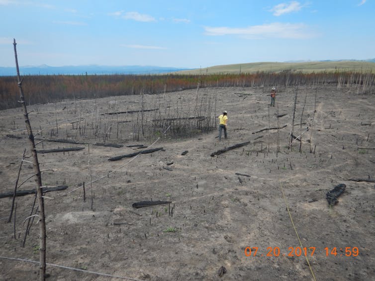
The 2016 Maple fire (photographed in July 2017) reburned young forests that had regenerated after the 1988 Yellowstone fires. More frequent high-severity fires are expected in the future as climate warms, which may change patterns of forest recovery. Monica Turner, CC BY-ND
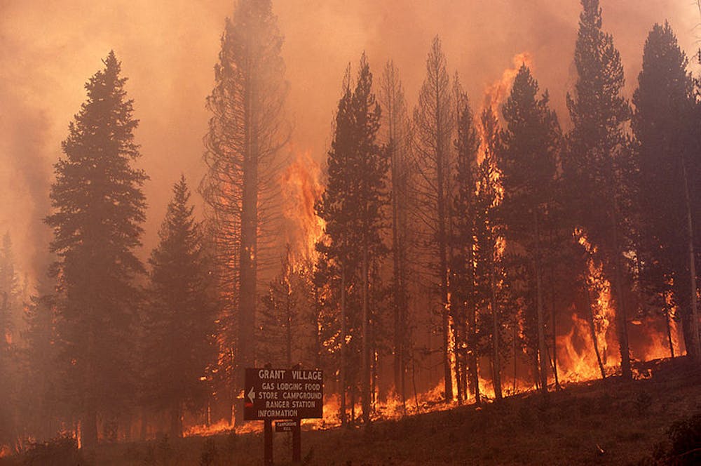
This summer marks the 30th anniversary of the 1988 Yellowstone fires – massive blazes that affected about 1.2 million acres in and around Yellowstone National Park. Their size and severity surprised scientists, managers and the public and received heavy media coverage. Many news reports proclaimed that Yellowstone was destroyed, but nothing was further from the truth.
I was there during the fires and returned that fall to view the aftermath. Burned forests extended for miles, with blackened tree trunks creating a stark and seemingly desolate landscape. But peering down from a helicopter, we were surprised to see that the fires had actually produced a mosaic of burned and unburned patches of forest.
Landscape pattern of burned and unburned trees after the Yellowstone fires, October 1988.Monica Turner, CC BY-ND
I have studied the recovery of Yellowstone’s forests since 1989, watching landscapes of charred trees transition into lush young forests. Fires play an important ecological role in many ecosystems, and Yellowstone’s native plants and animals are well-adapted to historical cycles of disturbance and recovery. Today the burned landscape is dominated by thriving young lodgepole pine trees.
We learned much about how ecosystems respond to such fires because they burned mostly in national parks and wilderness areas. Post-fire management was minimal, and nature took its course through most of the burned area.
Because Yellowstone’s forests were remarkably resilient, the 1988 fires were not an ecological catastrophe. Today, however, climate and fire trends may be pushing forests beyond their limits. The rules of the game are changing fast.
Post-1988 young lodgepole pine forests, photographed in 2014.Monica Turner, CC BY-ND
Heat, drought and wind
Extreme weather conditions drove the 1988 fires, as they have fostered many recent fires across the West. Summers in Yellowstone are usually too cool and moist for such large fires, but the summer of 1988 was and remains the driest on record there.
Amounts of fuel (dead logs and pine needles on the ground and live trees) were not unusual, and there is no evidence that suppression of prior fires had much, if any, influence on the 1988 fires. Hot temperatures, severe drought and high winds set the stage.
Gusts over 60 miles per hour prevented me from flying over the fires in early July, well before the blazes made their biggest runs. Roads, rivers and even wide canyons spanning the Yellowstone and Lewis rivers did not stop flames from spreading on windy days. Strong winds carried burning branches ahead of the main fire front, advancing fire spread. The fires also continued to burn at night.
Lodgepole pines have thin bark and are readily killed, but often bear fire-adapted cones that allow them to regenerate right after fires. When heated, the cones release vast quantities of seeds that produce a new generation of trees. Fires also create ideal growing conditions, with plenty of mineral soil and sunlight.
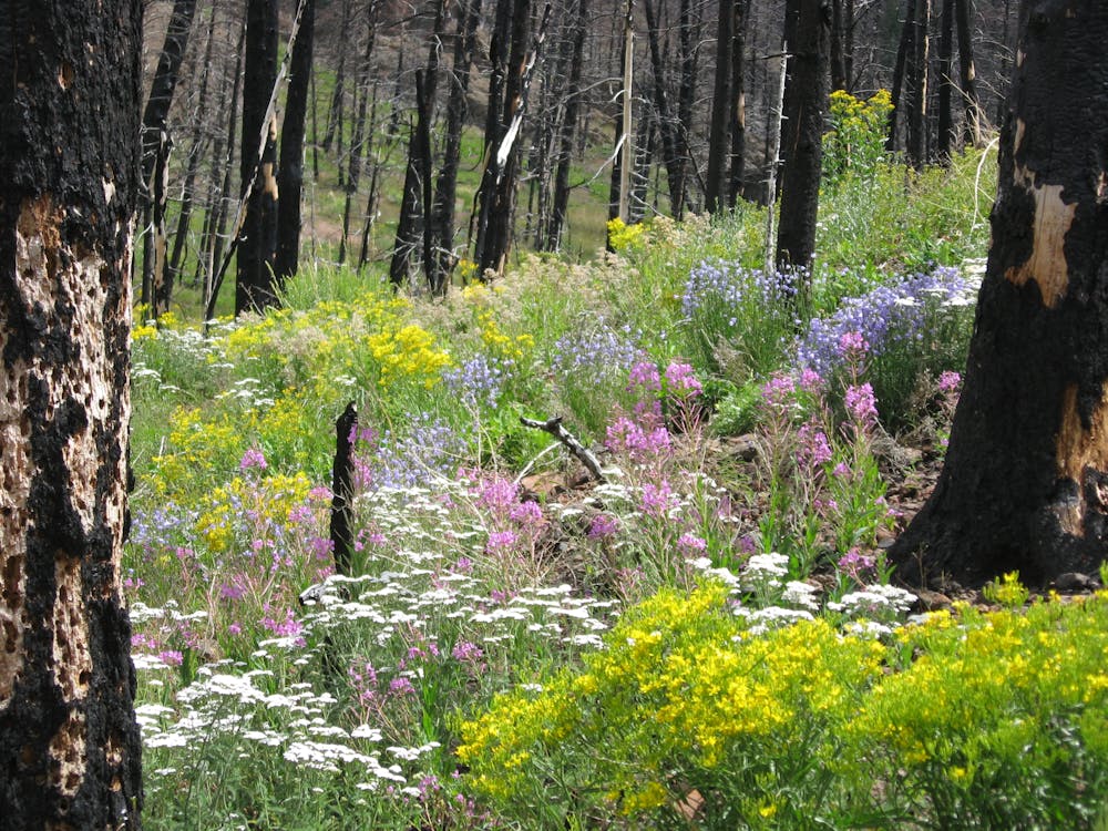
Wildflowers flourish three years after the 2008 Gunbarrel fire east of Yellowstone.Monica Turner, CC BY-ND
In Yellowstone, wildflowers and grasses sprouted from surviving roots because soils did not burn deeply and retained key nutrients needed for plant growth. Native species steadily filled in the bare spots. Aspens – long a species of concern in the northern Rockies – established from seed throughout the burned pine forests, many miles from the nearest mature aspen trees. Many are doing well at higher elevations than their pre-fire distribution.
Yellowstone’s ecosystems recovered rapidly on their own. I suspect that many visitors no longer “see” evidence of the 1988 fires as they admire scenery and wildlife amidst a sea of green. Similar patterns of natural recovery following 20th-century fires have also been observed in Rocky Mountain, Glacier and Grand Teton National Parks, which also have evolved with fire for millennia. Historically, high-severity fires kill trees but do not destroy the forest.
Huckleberry Mountain in Glacier National Park after a fire on July 30, 1935 (top) and July 9, 2009 (bottom).National Park Service
Warming climate, more fire
The 1988 fires ushered in a new era of major wildfires that are burning more western forests each year. Summers and winters are getting warmer, and the hot, dry weather associated with large fires is no longer so rare. Snow melts earlier each year, fuels dry out sooner, temperature records are broken and fire season gets longer. Recent fires have burned in many national parks and monuments, including Bandelier, Rocky Mountain, Glacier and Yosemite.
And while lightning ignites most fires in the northern Rockies, human ignitions are lengthening fire seasons in populated areas. Even in the moist mixed forests of the southern Appalachians, severe drought allowed a human-caused fire that started in Great Smoky Mountains National Park to rage into Gatlinburg, Tennessee.
What lies ahead?
Even forests that are well-adapted to large, severe fires are at risk in a warming world. By the late 21st century, hot, dry weather like the summer of 1988 could be the rule rather than the exception in Yellowstone.
Large fires are expected to occur more often, and are already starting to reburn forests long before they have had enough time to recover. In Yellowstone and Grand Teton National Parks, fires in 2016 burned young forests that regenerated from fires in 1988 and 2000. Our studies of these recent fires have documented greater burn severity and fewer post-fire tree seedlings. Survival of these young trees is not guaranteed, as they are starting out in a much warmer world.
Big and severe fires are now burning more frequently and could threaten the resilience of Western forests.
National parks anchor many of the country’s last intact landscapes, and are among our best living laboratories for understanding environmental change. Research on the 1988 fires now provides a reference for assessing effects of more recent fires. Yellowstone will still maintain its beauty, native species and power to inspire us. However, only time will tell whether Yellowstone’s forests can maintain their ability to recover from fire in the decades ahead.

 How to resolve AdBlock issue?


 The 2016 Maple fire (photographed in July 2017) reburned young forests that had regenerated after the 1988 Yellowstone fires. More frequent high-severity fires are expected in the future as climate warms, which may change patterns of forest recovery.


