How to resolve AdBlock issue?
 The National Weather Service's Eureka Office is predicting up to 12 inches of additional rain from Saturday through Tuesday for portions of Lake County.
The forecast also predicts strong southerly winds, heavy high elevation snow, and a new widespread flooding threat from heavy rainfall atop of already saturated ground.
The National Weather Service placed all of Lake County under a flood watch from 4 a.m. Saturday, Jan. 7, to 4 p.m. Tuesday, Jan. 10. Forecasters also issued a hazardous weather outlook for Lake County.
Areas including Lakeport and the Northshore are expected to have up to 7 inches of rain in that time.
Cobb, Kelseyville and southern Lake County are forecast to get more rain, with predictions putting Cobb at more than 11 inches in that time frame.
The winds in the forecast for Lake County could be as high as 25 miles per hour, with gusts in the 40s. Across the region, ridges could see gusts of up to 60 miles per hour.
Temperatures into next week will mostly hover in the high 40s, moving into the low 50s on Sunday, Monday and then on Thursday, with nighttime lows in the low 40s.
Pacific Gas and Electric on Friday continued to restore power around Lake County and the rest of its service areas.
By Friday night, the company reported that about 50 Lake County customer accounts were still waiting for restoration, which the company reported was expected to be complete by Saturday.
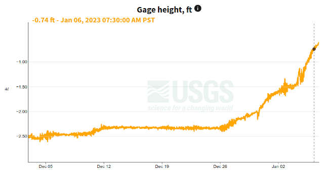
Even after a minor break in the rain on Friday, Clear Lake’s level continued to move up, according to the United States Geological Survey gauge.
By late Friday, Clear Lake was at -0.63 feet Rumsey, the special measure for the lake.
The lake level had been hovering around -2.34 feet Rumsey just before Christmas.
Email Elizabeth Larson at This email address is being protected from spambots. You need JavaScript enabled to view it.. Follow her on Twitter, @ERLarson, or Lake County News, @LakeCoNews.