
 How to resolve AdBlock issue?
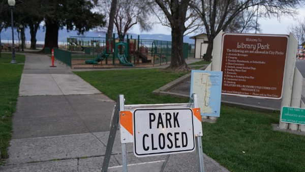
LAKE COUNTY, Calif. — As forecasters had warned, a powerful winter storm brought heavy rain to Lake County and much of California on Wednesday, prompting a statewide emergency and local measures to address flooding and other impacts of the storm.
For Lake County, the National Weather Service has issued a flood watch that’s in effect until 5 p.m. Thursday and a wind advisory until 10 a.m. Thursday, as well as a hazardous weather outlook.
Gov. Gavin Newsom on Wednesday also proclaimed a state of emergency in order to mobilize state agencies to respond to the storm situation developing across the state.
The storm — which forecasters called a “bomb cyclone” and an atmospheric river — dropped heavy rain across Lake County on Wednesday.
The highest rainfall totals were near Lake Pillsbury, at more than 2.6 inches, and the Cobb area, where more than 4 inches were recorded.
With the rain came high winds, which led to downed trees and road hazards across the county.
Road hazards across California led Caltrans on Wednesday morning to activate 1,200 electronic highway signs statewide to display urgent safety messaging.
On Wednesday afternoon, the city of Lakeport closed Library Park until further notice due to fallen tree branches that resulted from the storm.
The city asked people to stay out of the area until a notification is issued for the park’s reopening.
To report falling tree branches in the Library Park or throughout the city of Lakeport, officials asked community members to call Cit Hall at 707-263-5615 or the Lakeport Police Department’s nonemergency line, 707-263-5491.
The storm also led to numerous power outages, particularly across Kelseyville and southern Lake County, where thousands of residents were reported to be without power on Wednesday night.
In Clearlake, the city reported Wednesday evening that a downed tree and power lines had blocked the area of Arrowhead Drive from Covelo Street to Ciwa Street.
Shortly before 10 p.m., the Clearlake Police Department said another downed tree was blocking Austin Drive and Schultz Avenue.
Heavy rain is expected to continue during the day on Thursday, but the National Weather Service said rain and winds are anticipated to ease Thursday night and into Friday.
However, for the North Coast region including Lake County, the forecast shows little respite, with rain and southerly winds expected to begin increasing Friday night through Saturday night from a weaker cyclone forming downstream of highly invigorated jet stream winds over the Pacific.
The National Weather Service said that the impending cyclone and another atmospheric river will fan out over the West Coast this weekend.
Although the weekend storm won’t be as windy as this midweek storm — gusts will be around 30 to 40 miles per hour, not 60 miles per hour — it will bring still more heavy rain.
The forecast says that from Thursday through Saturday night, parts of Lake County could see close to 6.5 inches of rain, and still more rain next week.
The heavy rain has helped Clear Lake start to make up its deficit.
The United States Geological Survey gauge on Clear Lake showed it was -2.18 feet Rumsey, the special measure for the lake, on Dec. 29.
Since then it has begun trending rapidly upward, reaching -1.28 feet Rumsey early Thursday morning.
For information on weather conditions, the National Weather Service forecast can be found here.
Emergency information is posted at https://www.facebook.com/lakesheriff and https://www.facebook.com/LakeCountyOES.
Email Elizabeth Larson at This email address is being protected from spambots. You need JavaScript enabled to view it.. Follow her on Twitter, @ERLarson, or Lake County News, @LakeCoNews.


