When you read the following paragraph, consider the following: Tornado season hasn't even started yet.
On Jan. 22 and 23, 2012, more than 37 tornadoes struck the southern USA. Ten of them tore across the Lower Mississippi Valley into Alabama.
Worst hit were St. Clair and Jefferson County, Ala., where 2 people were killed, about 100 others injured, and at least $30 million in damage was done. It was a chilling reminder of the April 2011 onslaught of deadly tornadoes that took a staggering toll across southern and Midwestern states.1
In southern parts of the USA, tornado season tends to peak in springtime. Yet January 2012 produced 73 winter tornadoes – third most of any January in recorded history.
Most of them struck southern states. And since over a quarter of the incredible 1,688 twisters confirmed across the US in 2011 occurred in the four-state region of Alabama, Georgia, Mississippi and Tennessee, residents there are becoming ever more wary of darkening skies.
“Even with our advances in science and communications, we can still be surprised by the deadliest storms,” said NOAA scientist Steve Goodman. “But NOAA is working with NASA and university researchers to give more lead time in tornado warnings.”
Southern tornadoes are especially insidious and challenging to track. The hilly, forested terrain in southern states makes an approaching twister harder to spot than in the flat Midwest. In the south you might not see the first evidence of an approaching tornado until it's almost in your back yard.
An Alabama resident describes the scene just before one of the April 2011 twisters struck near his home: “Suddenly, all the trees in my back yard corkscrewed violently, in unison, toward the northwest.” Moments later, the storm was there.
Rain wrapped tornadoes are especially hard to see, as are night-time tornadoes. And records indicate that southern tornadoes often strike at night.
To reduce the surprise, NOAA and NASA2 are developing the Geostationary Operational Environmental Satellite-R, or “GOES-R series,” with the first expected to launch in late 2015.
These next-generation weather satellites bristle with state-of-the-art instruments for improved scouting of these killer storms, even at night.
Tornadoes are, by their very nature, difficult to pin down. The Advanced Baseline Imager (ABI) on GOES-R will improve meteorologists' ability to assess conditions that spawn twisters.
Compared to current GOES imagers, the ABI provides twice the spatial resolution, three times as many channels of information, and more than five times the update rate.
“ABI will give us a much clearer picture of the clouds – where and how tall they are, how much and what kind of moisture they hold, and how they are moving and intensifying,” said NOAA research meteorologist Tim Schmit.
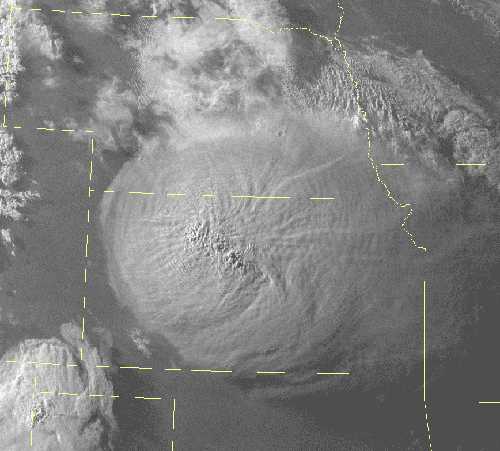
Most importantly, ABI can better detect the super-cold “overshooting tops” that mean severe weather is imminent. “Overshooting tops portend huge energy inside the cloud – it takes tremendous energy and upward velocity to poke through the lid of the tropopause,” explained Schmit.
“During episodes of severe weather, ABI can show conditions every 30 to 60 seconds. The system in use now only shows them every 7.5 minutes. And in normal mode, ABI will send readings over the continental U.S. every 5 minutes as opposed to every 15-30 minutes,” Schmit said.
Lightning is another key to tornadoes.
“Studies show that sudden changes in the total lightning correlate with [the onset of] tornadoes,” said Goodman.
Detecting lightning is a new specialty of GOES-R.
“GOES-R's Geostationary Lightning Mapper, or GLM, will see all the lightning: cloud-to-ground, cloud-to-cloud, and inside each cloud. And since this is the first time we'll have lightning detection from geostationary orbit, it means GOES-R will constantly monitor and map the lightning across the western hemisphere,” Goodman said.
The GLM is expected to give seven more minutes of lead time in tornado warnings. Average lead time now is 13 minutes.
“With GOES-R you'll have upwards of 20 minutes to get to a safe haven,” said Goodman.
That sure beats standing in your back yard, in the dark, waiting for the trees to twist.
Dauna Coulter writes for the National Aeronautics and Space Administration.
Follow Lake County News on Twitter at http://twitter.com/LakeCoNews, on Tumblr at www.lakeconews.tumblr.com , on Google+, on Facebook at www.facebook.com/pages/Lake-County-News/143156775604?ref=mf and on YouTube at www.youtube.com/user/LakeCoNews .

 How to resolve AdBlock issue?


