Clay Shannon with the Climate Crisis Champion Award. Photo courtesy of the office of Congressman Mike Thompson. LAKE COUNTY, Calif. — In a Sunday ceremony in Napa County, Rep. Mike Thompson (CA-04) recognized Clay Shannon as Lake County’s 2024 Climate Crisis Champion.
“Through his advocacy, Mr. Shannon has demonstrated how responsible farming can help address the impacts of climate change,” said Thompson. “As the owner of Shannon Family of Wines, Mr. Shannon has dedicated himself to advancing responsible farming that reduces the carbon footprint of farms.
"In 2018, Mr. Shannon began farming his 2,500 acres of land organically, and since then he’s integrated his sheep farming operation with his vineyard, dramatically reducing the need for mowing, fungicides, and conventional fertilizers in his vineyard. Mr. Shannon’s work to advance environmental stewardship in the 4th District’s farming community is inspiring, and I am honored to name him a Climate Crisis Champion,” Thompson said.
Shannon is a well known winegrape growers and wine producer.
He’s also owner of The Mercantile in Kelseyville.
Thompson awarded this year’s Climate Crisis Champions across each of the five counties in the Fourth District: Lake, Napa, Solano, Sonoma, and Yolo.
Champions are selected for their significant efforts to combat the ongoing climate crisis and protect the environment at home in their community.
Through their advocacy, champions are helping to build a more sustainable future for all, Thompson’s office said.
In addition to Shannon, the rest of the district’s winners were:
• Napa Schools for Climate Action (Napa); • Ian Anderson (Solano); • Dr. Lisa Micheli (Sonoma); and • Maria Contreras Tebbutt (Yolo).
CLEARLAKE, Calif. — The Lake County Campus of Woodland Community College will host an Earth Day celebration on Thursday, April 18, from 11 a.m. to 3 p.m.
During the event, community members will have the opportunity to learn about the more than 50 degree and certificate programs available at the college and the supportive services offered to students and the community.
College President Dr. Lizette Navarette and Yuba College District Chancellor Dr. Shouan Pan will be available from 1 to 2:30 p.m. to visit with community members during the event.
In conjunction with the Earth Day celebration, Aromas will be open for food purchases. Underdog Grill will also be available for food purchases.
Kehaulani Hula Studio will perform during the event. Family-friendly activities will be provided as well as information from local agencies.
Join the college to learn more about the local community college and for an afternoon of fun.
For more information contact Mary Wilson at 707-995-7913 or This email address is being protected from spambots. You need JavaScript enabled to view it..
LAKE COUNTY, Calif. — National Public Safety Telecommunicators Week, April 14 to 20, is an opportunity to shine the light on the unseen heroes who keep us safe in our times of greatest need.
Public safety dispatchers play a critical role in orchestrating emergency response efforts, providing vital information to both the callers and emergency responders.
“These women and men are the first point of contact during an emergency, navigating a crisis with composure and expertise to provide vital instructions, while seamlessly coordinating efforts behind the scenes,” said California Highway Patrol Commissioner Sean Duryee. “Their dedication and unwavering commitment to public service deserve praise and recognition.”
The CHP has more than 700 dedicated professionals who serve in that role, working on the front lines of public safety and service, fielding a vast majority of cellular 9-1-1 calls in the state.
Last year, the CHP handled approximately 6.6 million calls for service statewide. Of those calls, 4.6 million were to 9-1-1.
In addition to their primary responsibilities, dispatchers often act as lifelines for individuals in distress offering reassurance, guidance, and support until help arrives.
Their ability to remain calm under pressure, think quickly on their feet, and maintain professionalism in the face of chaos is truly commendable.
The CHP has several openings for public safety dispatchers and public safety operators and is actively recruiting Californians to answer the call of this rewarding career.
For more information, register to attend an online hiring seminar at 6:30 p.m. on Wednesday, April 24. Or take the next step and apply today.
The mission of the CHP is to provide the highest level of safety, service and security.
LAKEPORT, Calif. — The Lakeport Police Department is participating in the United States Drug Enforcement Administration National Prescription Drug Take Back Day on Saturday, April 27, from 10 a.m. to 2 p.m.
The event will be held at the front lobby entrance of the police station at 2025 S. Main St.
Items that will be accepted include all over-the-counter or prescription medication in pill, tablet, liquid, cream or capsule form including schedule II-V controlled and non-controlled substances.
Pills need to be emptied out of their containers and placed in a plastic bag (not paper, so the contents can be seen to verify they are eligible to be accepted).
Vape pens or other e-cigarette devices from individual consumers will be accepted only after the batteries are removed from the devices.
Not accepted: Illegal drugs, needles, inhalers or aerosol cans.
The Lakeport Police Department has collected over 1,257 pounds of prescription drugs since it began participating in this program in January 2019. Many of these drugs were dangerous narcotics, including opioids.
“Removal of prescription drugs in this safe manner protects our community by keeping them from being diverted to illegal use and out of the environment and water sources,” the department said in its announcement.
For more information contact Chief of Police Brad Rasmussen at 707-263-5491.
LAKE COUNTY, Calif. — The Board of Supervisors this week will discuss a plan to expand the county’s Road Map Task Force — with its mix of code enforcement and increased policing — to the Lucerne and Nice areas.
The board will meet beginning at 9 a.m. Tuesday, April 16, in the board chambers on the first floor of the Lake County Courthouse, 255 N. Forbes St., Lakeport.
The meeting ID is 865 3354 4962, pass code 726865. The meeting also can be accessed via one tap mobile at +16694449171,,86533544962#,,,,*726865#. The meeting can also be accessed via phone at 669 900 6833.
In an item timed for 10:30 a.m., the board will consider a presentation from sheriff’s office and Community Development Department staff regarding the Road Map Task Force accomplishments and lessons learned in Clearlake Oaks, and proposed community oriented policing and targeted restoration for Nice, Lucerne and other shoreline area communities for fiscal years 2024/25 through 2026/27.
The proposal for the three-year project has a budget totaling $1,312,348, and will be based in the Lucerne sheriff’s substation.
The full agenda follows.
CONSENT AGENDA
5.1: Adopt proclamation designating April 2024 as Child Abuse Prevention Month.
5.2: Adopt proclamation commending Laura Calderon for her 23 years of service to the county of Lake.
5.3: Adopt proclamation designating the week of April 21 to 27, 2024, as National Crime Victims’ Rights Week.
5.4: Approve Board of Supervisors minutes for March 26, April 2 and April 9, 2024.
5.5: Adopt proclamation designating the week of April 14 to 20, 2024, as National Public Safety Dispatchers Week.
5.6: a) Waive the formal bidding process pursuant to County Ordinance 3109 Section 2-38 due to 38.2(3), not in the public interest as competitive bidding would produce no economic benefit to the county; and b) approve eighth amendment to the lease agreement between county of Lake and NL Family Trust/KLA Family Trust for the property located at 1216, 1222 and 1228 South Main Street in Lakeport, for $22,800 from July 1, 2024, to June 30, 2025, $23,820 from July 1, 2025 to June 30, 2026, and $24,840 from July 1, 2026 to June 30, 2027, and authorize the chair to sign.
5.7: a) Waive the formal bidding process pursuant to County Ordinance 3109 Section 2-38 due to 38.2(3), not in the public interest as competitive bidding would produce no economic benefit to the county; and, b) approve contract to lease agreement between county of Lake and OMarshall Inc. for the property Located at 16170 Main St. in Lower Lake, in the amount of $62,436 per fiscal year from July 1, 2024 to June 30, 2027, and authorize the chair to sign.
TIMED ITEMS
6.2, 9:03 a.m.: Pet of the Week.
6.3, 9:04 a.m.: Presentation of proclamation designating the week of April 21 to 27, 2024, as National Crime Victims’ Rights Week.
6.4, 9:05 a.m.: Presentation of proclamation designating April 2024 as Child Abuse Prevention Month.
6.5, 9:06 a.m.: Presentation of proclamation commending Laura Calderon for her 23 years of service to the county of Lake Behavioral Health Services Department.
6.6, 9:07 a.m.: Presentation of proclamation designating the week of April 14 to 20, 2024, as National Public Safety Dispatchers Week.
6.7, 9:10 a.m.: Sitting as the Lake County Watershed Protection District, (a) consideration of the cooperative agreement with Caltrans to provide Blue Lakes Safety Project Mitigation funds to support the Clover Creek Hitch Habitat Restoration Project in an amount not to exceed $246,492 and authorize the Water Resources director to sign the agreement; and (b) consideration of a presentation of the proposed project.
6.8, 10 a.m.: WITHDRAWN — PUBLIC HEARING (a) consideration and presentation of the fire mitigation fee nexus studies; and (b) consideration of ordinance amendments to increase fire mitigation fees.
6.9, 10:30 a.m.: Consideration of presentation on Road Map Task Force accomplishments, lessons learned, and proposed community oriented policing and targeted restoration for Nice, Lucerne and other shoreline area communities for fiscal years 2024/25 through 2026/27.
6.10, 11 a.m.: Consideration of an agreement between the county of Lake and PlaceWorks in the not-to-exceed amount of $253,520, for Lake County Housing Action and Implementation Plan consulting services.
UNTIMED ITEMS
7.2: Consideration of the Classification, Compensation, Recruitment, and Retention Committee (CCRR) 2023-2024 Reclassification Cycle findings and recommendations.
7.3: Consideration of the following Advisory Board appointments: Heritage Commission; Glenbrook Cemetery District.
CLOSED SESSION
8.1: Public employee appointment pursuant to Gov. Code Section 54957(b) (1): Interviews for Social Services director; appointment of Social Services director.
8.2: Public employee appointment pursuant to Gov. Code Section 54957(b) (1): Interviews for Public Works director; appointment of Public Works director.
8.3: Public employee appointment pursuant to Gov. Code Section 54957(b) (1): Interviews for Water Resources director; appointment of Water Resources director.
Email Elizabeth Larson at This email address is being protected from spambots. You need JavaScript enabled to view it.. Follow her on Twitter, @ERLarson, or Lake County News, @LakeCoNews.
The more scientists learn about the health risks of PFAS, found in everything from nonstick cookware to carpets to ski wax, the more concerning these “forever chemicals” become.
The U.S. Environmental Protection Agency now believes there is no safe level for two common PFAS – PFOA and PFOS – in drinking water, and it acknowledges that very low concentrations of other PFAS present human health risks. The agency issued the first legally enforceable national drinking water standards for five common types of PFAS chemicals, as well as PFAS mixtures, on April 10, 2024.
I study PFAS as an environmental health scientist. Here’s a quick look at the risks these chemicals pose and efforts to regulate them.
What exactly are PFAS?
PFAS stands for per- and polyfluoroalkyl substances. This is a large group of human-made chemicals – currently estimated to be nearly 15,000 individual chemical compounds – that are used widely in consumer products and industry. They can make products resistant to water, grease and stains and protect against fire.
Waterproof outdoor apparel and cosmetics, stain-resistant upholstery and carpets, food packaging that is designed to prevent liquid or grease from leaking through, and certain firefighting equipment often contain PFAS.
In fact, studies have found that most products labeled stain- or water-resistant contain PFAS, and another study found that this is even true among products labeled as “nontoxic” or “green.” PFAS are also found in unexpected places such as high-performance ski and snowboard waxes, floor waxes and medical devices.
Firefighters are concerned that PFAS in firefighting foams and protective gear could be a reason cancer rates are rising.AP Photo/Steven Senne
At first glance, PFAS sound pretty useful, so you might be wondering what’s the big deal?
The short answer is that PFAS are harmful to human health and the environment.
Some of the very same chemical properties that make PFAS attractive in products also mean these chemicals will persist in the environment for generations. Because of the widespread use of PFAS, these chemicals are now present in water, soil and living organisms and can be found across almost every part of the planet, including Arctic glaciers, marine mammals, remote communities living on subsistence diets and in 98% of the American public.
Once people are exposed to PFAS, the chemicals remain in their bodies for a long time – months to years, depending on the specific compound – and they can accumulate over time.
Research consistently demonstrates that PFAS are associated with a variety of adverse health effects. A review by a panel of experts looking at research on PFAS toxicity concluded with a high degree of certainty that PFAS contribute to thyroid disease, elevated cholesterol, liver damage, and kidney and testicular cancer.
Further, they concluded with a high degree of certainty that PFAS also affect babies exposed in utero by increasing their likelihood of being born at a lower birth weight and responding less effectively to vaccines, while impairing women’s mammary gland development, which may adversely affect a mom’s ability to breastfeed.
The review also found evidence that PFAS may contribute to a number of other disorders, though further research is needed to confirm existing findings: inflammatory bowel disease, reduced fertility, breast cancer, and an increased likelihood of miscarriage and developing high blood pressure and preeclampsia during pregnancy. Additionally, current research suggests that babies exposed prenatally are at higher risk of experiencing obesity, early-onset puberty and reduced fertility later in life.
Collectively, this is a formidable list of diseases and disorders.
Who’s regulating PFAS?
PFAS chemicals have been around since the late 1930s, when a DuPont scientist created one by accident during a lab experiment. DuPont called it Teflon, which eventually became a household name for its use on nonstick pans.
Decades later, in 1998, Scotchgard maker 3M notified the Environmental Protection Agency that a PFAS chemical was showing up in human blood samples. At the time, 3M said low levels of the manufactured chemical had been detected in people’s blood as early as the 1970s.
The Agency for Toxic Substances and Disease Registry has a toxicological profile for PFAS. And the EPA had issued advisories and health-based guidelines. But despite the lengthy list of serious health risks linked to PFAS and a tremendous amount of federal investment in PFAS-related research in recent years, PFAS hadn’t been regulated at the federal level in the United States until now.
The new drinking water standards set limits for five individual PFAS – PFOA, PFOS, PFNA, PFHxS and HFPO-DA – as well as mixtures of these chemicals. The standards are part of the EPA’s road map for PFAS regulations.
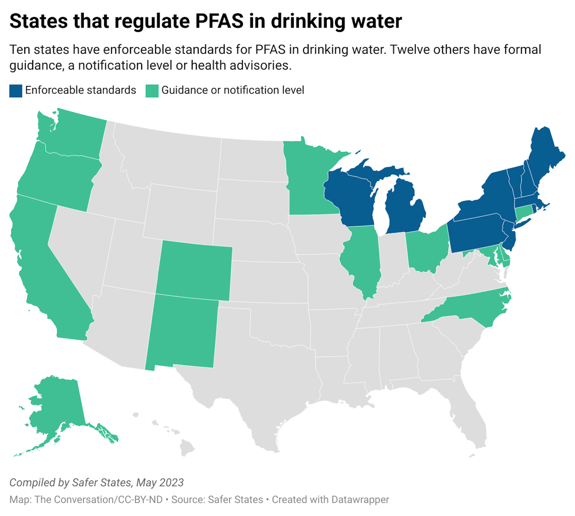
While waiting for federal action, states have taken their own steps to protect residents against the risk of PFAS exposure.
At least 28 states have laws targeting PFAS in various uses, such as in food packaging and carpets. About a dozen have drinking water standards for PFAS. But relying on state laws creates a patchwork of regulations, which places burdens on businesses and consumers to navigate regulatory nuances across state lines.
How can you reduce your PFAS exposure?
Based on current scientific understanding, most people are exposed to PFAS primarily through their diet, though drinking water and airborne exposures may be significant among some people, especially if they live near known PFAS-related industries or contamination.
The best ways to protect yourself and your family from risks associated with PFAS are to educate yourself about potential sources of exposure.
Products labeled as water- or stain-resistant have a good chance of containing PFAS. When possible, check the ingredients on products you buy and watch for chemical names containing “fluor-.” Specific trade names, such as Teflon and Gore-Tex, are also likely to contain PFAS.
Check whether there are sources of contamination near you, such as in drinking water or PFAS-related industries in the area. Strategies for monitoring and reporting PFAS contamination vary by location and PFAS source, so the absence of readily available information does not necessarily mean the region is free of PFAS problems.
If you believe you have been exposed to PFAS and are concerned about your health, contact your health care provider. The National Academies of Sciences, Engineering, and Medicine have published guidance on PFAS exposure, testing and clinical follow-up, which includes information to help health care professionals understand monitoring and clinical implications of PFAS exposure.
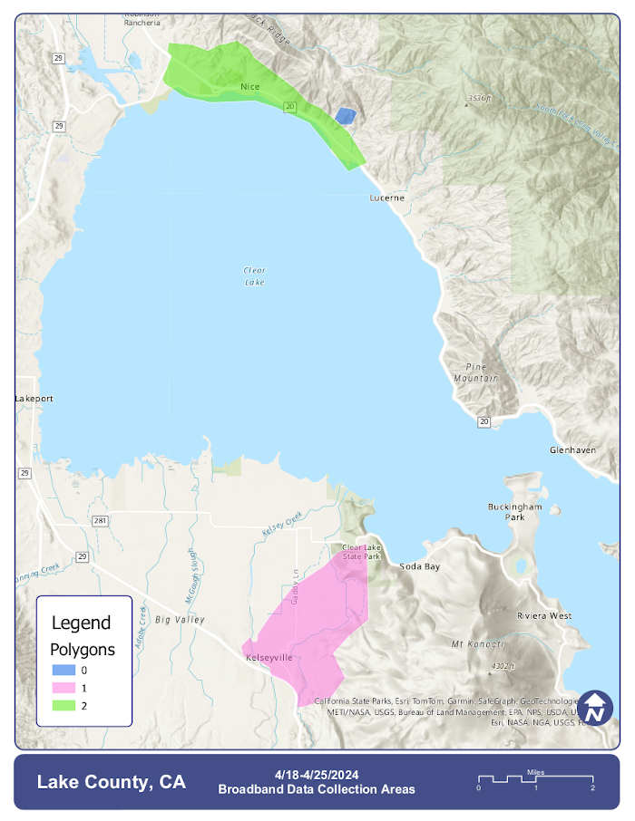
LAKE COUNTY, Calif. — The county of Lake has issued an advisory to community members regarding drone data collection set to begin this week.
From April 18 to 25, AirWorks crews will be collecting data to support preparedness for future broadband installation work in portions of Lake County, officials reported.
This data collection will support implementation of Lake County’s updated Broadband Master Plan, which is currently under development in partnership with CBG Communications Inc.
These operations include use of drones flying at 200 to 3,000 feet (weather permitting), and some ground crews taking measurements and conducting safety checks.
Work will be done between 7 a.m. and 5 p.m. each day.
The map above depicts the areas expected to be surveyed — roughly 40 miles, in total, in the Nice and Kelseyville areas.
Data regarding utility structures (poles and wires), roads, sidewalks and curbs will be collected, and used for mapping purposes, only.
A digital map is accessible here; please note, the polygons demonstrating data collection areas may take some time to display.
LAKEPORT, Calif. – The Lakeport City Council this week will present two proclamations, meet a new employee, set a public hearing and consider awarding a project for a city project.
The council will meet Tuesday, April 16, at 6 p.m. in the council chambers at Lakeport City Hall, 225 Park St.
The council chambers will be open to the public for the meeting. Masks are highly encouraged where 6-foot distancing cannot be maintained.
If you cannot attend in person, and would like to speak on an agenda item, you can access the Zoom meeting remotely at this link or join by phone by calling toll-free 669-900-9128 or 346-248-7799.
The webinar ID is 973 6820 1787, access code is 477973; the audio pin will be shown after joining the webinar. Those phoning in without using the web link will be in “listen mode” only and will not be able to participate or comment.
Comments can be submitted by email to This email address is being protected from spambots. You need JavaScript enabled to view it.. To give the city clerk adequate time to print out comments for consideration at the meeting, please submit written comments before 3:30 p.m. on Tuesday, April 16.
On Tuesday, the council will meet new city employee Melissa Carpenter, and present proclamations designating April 2024 as Child Abuse Prevention Month and Sexual Assault Awareness Month.
The agenda includes a public hearing on a proposed ordinance revising Lakeport Municipal Code Chapter 3.34 regarding fire mitigation fees and direction to city staff to schedule a public hearing for the second reading of the ordinance for May 7.
Under council business, Community Development Director Joey Hejnowicz will ask the council to adopt a resolution for “Affirmatively Furthering Fair Housing” in Lakeport.
That will be followed by a request from Public Works Director Ron Ladd to approve the plans, specifications and working details and award a construction contract to T&T Paving, Inc. dba Valley Paving for the South Main Street Sidewalk Project and authorize City Manager Kevin Ingram to execute the construction contract for the bid amount of $334,279.15.
On the consent agenda — items considered noncontroversial and usually accepted as a slate on one vote — are ordinances; minutes of the City Council’s special meeting on March 28 and regular meeting on April 2; approval of application 2024-016, with staff recommendations, for the Missing and Murdered Indigenous People Day walk; adoption of the proposed resolution adopting a records retention schedule, and authorizing destruction of certain city records and rescinding Resolution No. 2908 (2023); and adoption of the resolution accepting construction of the Lakefront Park Project by Builder Solutions Inc. and authorization of the filing of the notice of completion.
Email Elizabeth Larson at This email address is being protected from spambots. You need JavaScript enabled to view it.. Follow her on Twitter, @ERLarson, or Lake County News, @LakeCoNews.
LAKE COUNTY, Calif. — Lake County Animal Care and Control has many dogs of various breeds waiting for their new homes.
Dogs available for adoption this week include mixes of Alaskan husky, American blue heeler, Anatolian shepherd, border collie, German shepherd, hound, Labrador Retriever, pit bull terrier, Rottweiler and Weimaraner.
Dogs that are adopted from Lake County Animal Care and Control are either neutered or spayed, microchipped and, if old enough, given a rabies shot and county license before being released to their new owner. License fees do not apply to residents of the cities of Lakeport or Clearlake.
Those dogs and the others shown on this page at the Lake County Animal Care and Control shelter have been cleared for adoption.
Call Lake County Animal Care and Control at 707-263-0278 or visit the shelter online for information on visiting or adopting.
The shelter is located at 4949 Helbush in Lakeport.
Email Elizabeth Larson at This email address is being protected from spambots. You need JavaScript enabled to view it.. Follow her on Twitter, @ERLarson, or Lake County News, @LakeCoNews.
Gov. Gavin Newsom on Monday signed legislation that reflects the early action budget agreement announced by the governor and legislative leaders earlier this month to reduce the shortfall by approximately $17.3 billion.
“This action strongly positions the state to pass a balanced budget in June that protects key programs Californians rely on,” said Newsom. “I thank our leaders in the Legislature for their commitment to finding common ground as we continue working towards responsibly meeting this challenge in the months ahead.”
Under AB 106, the Department of Finance will report to the Joint Legislative Budget Committee the list of items pursuant to the early action agreement that will no longer be included in the baseline budget forecast.
AB 106 is part of the early action agreement that contains a mix of $3.6 billion in reductions (primarily to one-time funding), $5.2 billion in revenue and borrowing, $5.2 billion in delays and deferrals, and $3.4 billion in shifts of costs from the general fund to other state funds.
Nearly 327,000 people in the United States experiencing homelessness lived in shelters, a small proportion (0.1%) of the U.S. population from 2018 to 2022 but higher than from 2013 to 2017, according to American Community Survey (ACS) 5-year estimates released in a working paper.
The 2013-2017 ACS, the previous 5-year ACS with no overlapping years, showed there were approximately 267,000 people (0.08% of the U.S. population) in shelters during that period.
A change in the number of people experiencing homelessness and living in shelters could be due to a change in economic circumstances or resources devoted to shelters or a combination of both.
Group quarters are places — owned or managed by an entity or organization providing housing and/or services for the residents — where people live or stay in a group arrangement.
They consist of institutional (residents primarily not eligible, able or likely to participate in the labor force) and noninstitutional (residents primarily eligible, able or likely to participate in labor force) facilities. Noninstitutional group quarters include places like college dorms and military housing and other noninstitutional facilities.
In the ACS, the sheltered population experiencing homelessness is sampled from facilities where people stay overnight as part of the noninstitutional facilities:
• That operate on a first-come, first-served basis where people must leave the next morning and have no guaranteed bed for another night. • Where people are assigned a bed for a specified period (even if they leave the building daily). • That provide temporary shelter during extremely cold weather (like churches). This category does not include shelters that operate only in the event of a natural disaster.
The sheltered population is an estimate of the population experiencing homelessness that stay in emergency and transitional shelters. It is not a complete count of the total U.S. population experiencing homelessness, which the Department of Housing and Urban Development (HUD) estimated was 582,500 in 2022. HUD conducts a Point-in-Time count of sheltered people experiencing homelessness on a single night in January every year and a count of unsheltered people every other year.
It’s important to note that some detailed group quarters types are included in the decennial census as “other noninstitutional facilities” but not in the ACS, which may lead to higher or overestimates of this population in the ACS. More information about this is available in Estimates of the Population Experiencing Homelessness and Living in Shelters.
Who are the people who stay in shelters?
Figure 1 shows the share of the sheltered population experiencing homelessness and the population in households and other living quarters (people who lived in households and in group quarters other than emergency shelters) by different demographic groups.
Among the sheltered population experiencing homelessness: 40% were female; 8% were under the age of 18; 8% were age 65 or over; 32% were non-Hispanic White; 37% were non-Hispanic Black; and 35% had a disability.
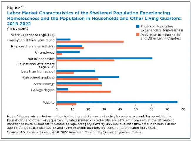
Figure 2 shows the labor market characteristics of both the sheltered population experiencing homelessness and the population in households and other living quarters.
Among the sheltered population age 16 and over experiencing homelessness, nearly 15% were unemployed and an additional 61% were not in the labor force. That means only about 25% of this population was employed compared to nearly 60% of the population in households and other living quarters.
Among the sheltered population age 25 and over experiencing homelessness, nearly 25% did not have a high school degree and just over 7% had a bachelor’s degree or higher. Low educational attainment and high unemployment likely contributed to a poverty rate over six times higher (76.5%) than for the population in households and other living quarters (12.5%).
Also important to note: nearly one quarter of people experiencing homelessness and living in shelters were not in poverty.
The national poverty rate in 2018-2022 was 12.53%. When excluding the sheltered population experiencing homelessness, the poverty rate was 12.47%, which is not significantly different statistically.
Sheltered population by state
There was a lot of variation in both the number and rate of the population experiencing homelessness in shelters in each state in 2018-2022.
The sheltered population ranged from a low of 173 people in Wyoming to a high of 83,550 people in New York. In fact, four states accounted for over 50% of the total U.S. sheltered population experiencing homelessness: New York (83,550); California (57,700); Texas (15,340); and Florida (13,260).
While 10 out of every 10,000 people lived in a shelter nationally, this rate ranged from a low of 1.5 in Mississippi to a high of 61.5 in the District of Columbia (Figure 3).
Figure 4 shows the ratio of the state share of the U.S. sheltered population to the state share of the total U.S. population. This tells us whether the share of the sheltered population experiencing homelessness in each state was higher or lower than the share of the total U.S. population in each state.
For example, New York had a ratio of 4.23 with about 6% of the U.S. population, but over 25% of the total sheltered population experiencing homelessness. Conversely, Texas had a ratio of 0.53 with nearly 9% of the U.S. population, but only about 5% of the total sheltered population experiencing homelessness.
The share of the sheltered population experiencing homelessness was higher than the state’s share of the U.S. population in 10 states and the District of Columbia and lower in 35 states. The ratio of the two population shares was not significantly different in 5 states.
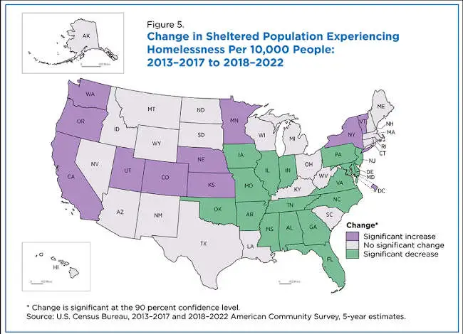
Figure 5 shows which states had a significant change in sheltered populations experiencing homelessness per 10,000 people in 2018-2022 compared to the 2013-2017 period.
While the number increased nationally, it only rose in 10 states and the District of Columbia. The sheltered population experiencing homelessness per 10,000 people decreased in 17 states and did not change significantly in the other 23 states.
Brian Glassman is an economist and chief of the Census Bureau’s Poverty Statistics Branch.
Stars like the Sun are remarkably constant. They vary in brightness by only 0.1% over years and decades, thanks to the fusion of hydrogen into helium that powers them. This process will keep the Sun shining steadily for about 5 billion more years, but when stars exhaust their nuclear fuel, their deaths can lead to pyrotechnics.
Supernovae happen across the Milky Way only a few times a century, and these violent explosions are usually remote enough that people here on Earth don’t notice. For a dying star to have any effect on life on our planet, it would have to go supernova within 100 light years from Earth.
In my writing about cosmic endings, I’ve described the threat posed by stellar cataclysms such as supernovae and related phenomena such as gamma-ray bursts. Most of these cataclysms are remote, but when they occur closer to home they can pose a threat to life on Earth.
The dying star emits high energy radiation as gamma rays. Gamma rays are a form of electromagnetic radiation with wavelengths much shorter than light waves, meaning they’re invisible to the human eye. The dying star also releases a torrent of high-energy particles in the form of cosmic rays: subatomic particles moving at close to the speed of light.
Supernovae in the Milky Way are rare, but a few have been close enough to Earth that historical records discuss them. In 185 A.D., a star appeared in a place where no star had previously been seen. It was probably a supernova.
Observers around the world saw a bright star suddenly appear in 1006 A.D. Astronomers later matched it to a supernova 7,200 light years away. Then, in 1054 A.D., Chinese astronomers recorded a star visible in the daytime sky that astronomers subsequently identified as a supernova 6,500 light years away.
At 600 light years away, the red supergiant Betelgeuse in the constellation of Orion is the nearest massive star getting close to the end of its life. When it goes supernova, it will shine as bright as the full Moon for those watching from Earth, without causing any damage to life on our planet.
Radiation damage
If a star goes supernova close enough to Earth, the gamma-ray radiation could damage some of the planetary protection that allows life to thrive on Earth. There’s a time delay due to the finite speed of light. If a supernova goes off 100 light years away, it takes 100 years for us to see it.
Astronomers have found evidence of a supernova 300 light years away that exploded 2.5 million years ago. Radioactive atoms trapped in seafloor sediments are the telltale signs of this event. Radiation from gamma rays eroded the ozone layer, which protects life on Earth from the Sun’s harmful radiation. This event would have cooled the climate, leading to the extinction of some ancient species.
Safety from a supernova comes with greater distance. Gamma rays and cosmic rays spread out in all directions once emitted from a supernova, so the fraction that reach the Earth decreases with greater distance. For example, imagine two identical supernovae, with one 10 times closer to Earth than the other. Earth would receive radiation that’s about a hundred times stronger from the closer event.
A supernova within 30 light years would be catastrophic, severely depleting the ozone layer, disrupting the marine food chain and likely causing mass extinction. Some astronomers guess that nearby supernovae triggered a series of mass extinctions 360 to 375 million years ago. Luckily, these events happen within 30 light years only every few hundred million years.
Left behind after a supernova explosion, neutron stars are city-size balls of matter with the density of an atomic nucleus, so 300 trillion times denser than the Sun. These collisions created many of the gold and precious metals on Earth. The intense pressure caused by two ultradense objects colliding forces neutrons into atomic nuclei, which creates heavier elements such as gold and platinum.
Neutron stars merge when gravity pulls them together, which releases intense radiation.
A neutron star collision generates an intense burst of gamma rays. These gamma rays are concentrated into a narrow jet of radiation that packs a big punch.
If the Earth were in the line of fire of a gamma-ray burst within 10,000 light years, or 10% of the diameter of the galaxy, the burst would severely damage the ozone layer. It would also damage the DNA inside organisms’ cells, at a level that would kill many simple life forms like bacteria.
Gamma-ray bursts may not hold an imminent threat to life on Earth, but over very long time scales, bursts will inevitably hit the Earth. The odds of a gamma-ray burst triggering a mass extinction are 50% in the past 500 million years and 90% in the 4 billion years since there has been life on Earth.
The most extreme astrophysical events have a long reach. Astronomers were reminded of this in October 2022, when a pulse of radiation swept through the solar system and overloaded all of the gamma-ray telescopes in space.
It was the brightest gamma-ray burst to occur since human civilization began. The radiation caused a sudden disturbance to the Earth’s ionosphere, even though the source was an explosion nearly 2 billion light years away. Life on Earth was unaffected, but the fact that it altered the ionosphere is sobering – a similar burst in the Milky Way would be a million times brighter.

 How to resolve AdBlock issue?


