How to resolve AdBlock issue?
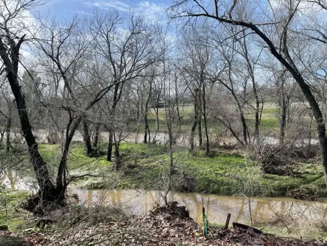
LAKE COUNTY, Calif. — The California Department of Water Resources reported that several more atmospheric river storms are in store for the state as some areas hit flood stage and reservoirs get a massive influx of runoff and rain.
With California facing still more storms through the middle of January, Department of Water Resources Director Karla Nemeth said Monday in a briefing with reporters that it was “yet another climate signal,” with California having both a drought and flood emergency.
Nemeth said California has been in the midst of a record-breaking drought up until a few weeks ago. However, she said that the state continues to be in a drought emergency.
As for the recent storms dumping large amounts of rain on California, “We will be reassessing in the later part of January what this means relative to overall drought,” Nemeth said, noting the large amount of variability across the state in terms of hydrological conditions and water availability.
There is still a long time left to go in a typical wet season, and Nemeth said there is a lot of other data to fill in to help understand California's longer term water supply picture.
The rain that fell on Monday came from the fifth atmospheric river storm in a series that started just after Christmas, said State Climatologist Dr. Michael Anderson.
A storm that will hit later this week is expected to have a longer duration and extend along the North Coast to the North Bay counties, he said.
“We will get some more rain out of that for a couple of days heading into the weekend,” Anderson said.
That’s one of four more atmospheric river storms forecast to hit California by Jan. 19 — bringing the total to nine — after which some dry conditions are expected to return.
Anderson said the forecast models show that after Jan. 19 the storms will die down and high pressure will build, blocking storms and pushing them to the north.
He explained that the storms are part of a sudden pattern shift that began in December, around Christmas, when a very strong jet stream brought storm after storm after storm.
There is more energy for the atmosphere to work with, leading to the interplay between the wet and dry cycles, Anderson said.
Jeremy Arrich, manager of the Department of Water Resources’ Division of Flood Management who is involved with the Flooding Operation Center — activated since Jan. 3 — said many monitored water locations across California were expected to reach flood stage late on Monday.
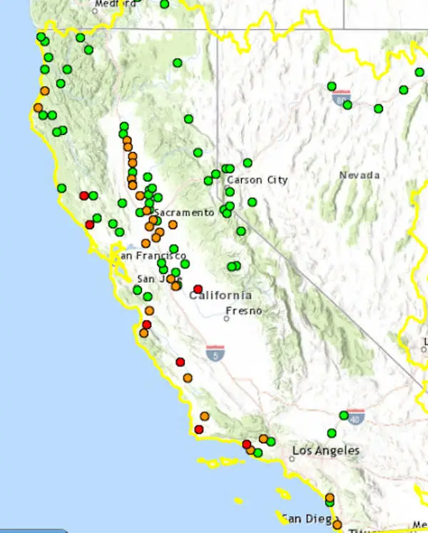
As of early Tuesday morning, the California Nevada River Forecast Center reported that there were 27 locations above monitor stage and seven above flood stage.
Clear Lake, which just passed onto the plus side of lake height over the weekend after being at its lowest level since the 1970s drought, was at 0.6 feet Rumsey late Monday and therefore was reported as being within “normal” conditions by the forecast center.
In neighboring Mendocino County, the Russian River at Hopland was fast approaching flood stage, with its level reported to be at 13.4 feet late Monday night, just short of the 15 foot flood stage.
The Russian River at Guerneville in Sonoma County was at 31.4 feet on Monday night, with its flood stage at 32 feet, the forecast center reported.
Arrich said the Russian River was among a handful of areas where the state was focusing its efforts to address flooding. The other areas are the Cosumnes River in Sacramento County, Bear Creek in Merced County, the Carmel River in Monterey County and the Pajaro River in Santa Cruz and Monterey counties.
He said on Monday afternoon that there had been no requests for assistance due to the Russian River’s high water, but that it’s an area the state monitors on a regular basis and that it had made the high water notification calls.
“We’re ready to assist when and if needed,” he said.
By Monday afternoon, Arrich said the Flood Operations Center had delivered flood fight materials and equipment to 13 counties, including more than 180,000 sandbags, six flood fight containers, 3,000 linear feet of reinforcing muscle wall, with flood fight specialists also deployed.
Arrich said the state also is communicating and making proactive outreach to local levee managers, counties and cities to keep them informed of high water conditions, and is continuing close coordination with the California Governor’s Office of Emergency Services, counties and emergency managers in areas that are anticipated to be impacted.
He said most levee operators are doing their own patrols.
The Department of Water Resources told Lake County News on Monday that at that point the Flood Operations Center had not received a specific request for assistance from Lake County at this time.
However, the agency said the center is in close contact with local agencies across the state and flood-fight materials and equipment have been positioned at 49 locations statewide to support state and local response efforts when requested.
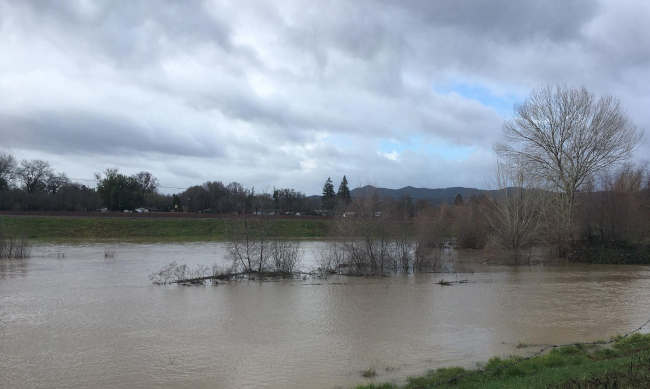
Around Lake County, creeks and streams are running high, and in Upper Lake, the water level is high in the Middle Creek and Clover Creek diversion levees.
John Yarborough, assistant deputy director of the State Water Project, said that although there has been significant inflow into the state’s reservoirs, there is still a lot of room to take in more water from the storms over the coming days. Statewide reservoir storage as of Jan. 8 was 78%.
He said Lake Shasta is 37% full and that Lake Oroville’s level has risen more than 77 feet since Dec. 1 thanks to taking in more than half a million acre feet of water.
Another half a million acre feet are expected to flow into Lake Oroville, bringing it up to two million acre feet. Yarborough said Lake Oroville has a capacity of 3.5 million acre feet.
While the storms are great, state officials said water supply conditions are still below average. Anderson said the reservoirs have been depleted and rebuilding the system’s storage will take time — he estimated a couple of years — and require not just more storms but also snowmelt.
Anderson said forecasters are waiting until after the larger storm event to do an analysis of it.
While each of the storms on its own hasn’t been that awe inspiring, Anderson said it’s a matter of having so many storms, one after another, with no break.
In the fall, forecasters expected a La Nina system to bring more dry conditions, and late in 2022, that pattern was holding, he said.
However, Anderson said it’s still a work in progress to understand large transitions such as these recent storms that happen suddenly.
He said forecasters are working with the research community to get better forecasts and lead time on weather events.
Email Elizabeth Larson at This email address is being protected from spambots. You need JavaScript enabled to view it.. Follow her on Twitter, @ERLarson, or Lake County News, @LakeCoNews.