
 How to resolve AdBlock issue?
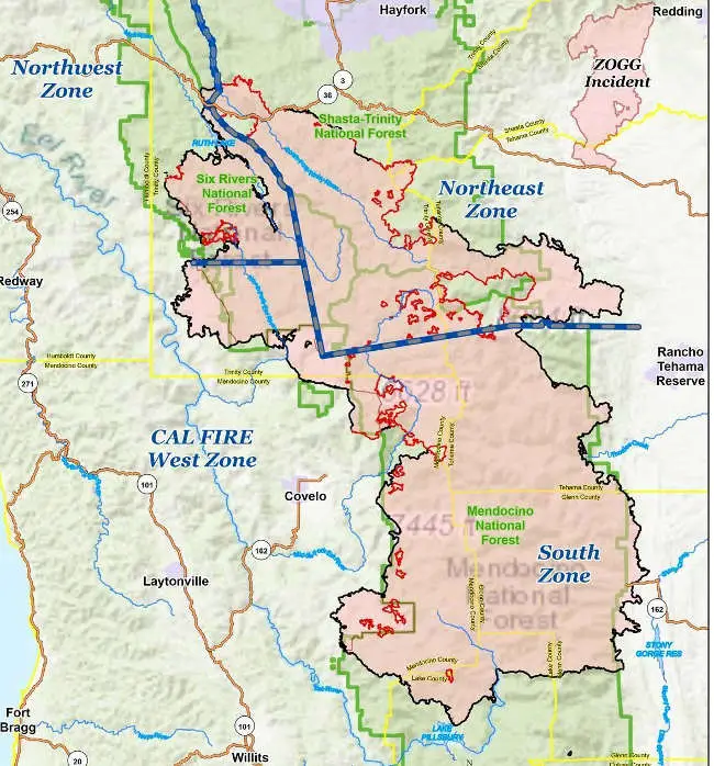
NORTHERN CALIFORNIA – For the second day in a row, growth on the August Complex has been held to under 500 acres as a new team prepares to begin assessing the damage to lands in the northern portion of the incident.
The August Complex was up to 1,029,605 acres and 77 percent containment across all four of its management zones on Wednesday night, according to the US Forest Service.
Officials said 4,254 personnel remain assigned across all zones of the complex, burning since Aug. 17.
The Southwest Area Incident Management Team 1 and Cal Fire Team 5 are working to protect Covelo area, officials said.
The Forest Service said firefighters completed the dozer line in the Middle Fork of the Eel River area. Control efforts in this area remain a priority. Aerial resources will be used to support firefighters on the ground as needed, the Forest Service reported.
As fuels dry out, officials said smoke may be visible in some areas within the fire’s perimeter. Fire will also likely be visible at night as it’s expected to remain active with the dry conditions. Remote sensing data helps inform firefighters where heat exists, to help them focus their efforts.
Firefighters continue to mop-up and cold trail the fireline near Bloody Rock where heat was detected in dozer berms. The Forest Service said cold trailing is a method of controlling a partly dead fire edge by carefully inspecting and feeling with the hand for heat to detect heat, digging out that heat and mopping it up.
Fire personnel and equipment are clearing road hazards, including downed and standing hazard trees, on the southwest side of the fire. The Forest Service said this will allow access for heavy equipment in preparation for suppression repair activities.
The incident’s managers also are watching weather conditions, as the region is under a red flag warning that signals the potential for critical fire weather.
Also on Wednesday, the Forest Service said a Burned Area Emergency Response, or BAER, team has been assigned the task of assessing the northern portion of the burned areas for the
August Complex.
The team will be coordinating with the Shasta-Trinity, Six Rivers and Mendocino national forests as well as the USDA Natural Resources Conservation Service, National Weather Service, US Geological Survey, Trinity County, Tehama County, Mendocino County and other federal,
tribal, state and local agencies as they assess potential post-fire impacts to the burned watersheds.
BAER surveys are rapid assessments that evaluate the burned area to identify watersheds having increased potential for post-fire flooding, sediment flows, falling trees, and rockslides. The BAER survey assists land managers in preparing the burned area for rainstorms and wind events.
The teams focus on potential emergency impacts to life and safety on National Forest System lands and share the team’s findings with the responsible downstream agencies.
The BAER team reported earlier this week that it had completed an assessment of the complex’s south area, as Lake County News has reported.


